Allt Beili-glas

Wood, Forest in Carmarthenshire

Wales

Allt Beili-glas

Sheep at Divlyn Sheep in a small field beside the farm of Divlyn in the Tywi/Towey valley.
Sheep at Divlyn Credit: Philip Halling

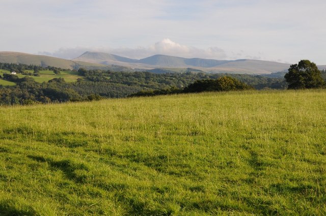
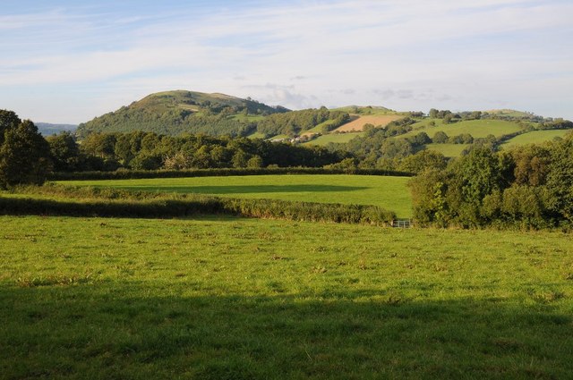
Allt Beili-glas is a picturesque wood located in Carmarthenshire, Wales. Nestled within the rolling hills and lush green landscape, it is a haven for nature enthusiasts and outdoor lovers. The wood covers an expansive area and is home to a diverse range of flora and fauna, making it an important habitat for wildlife.

The wood is predominantly made up of various types of trees, including oak, beech, ash, and birch. Their towering canopies provide shade and shelter, creating a cool and tranquil atmosphere. Walking through the wood, visitors will be greeted by a rich undergrowth of ferns, mosses, and wildflowers, adding a splash of vibrant colors to the scenery.

Allt Beili-glas offers several walking trails, allowing visitors to explore its beauty. The trails wind through the wood, meandering along babbling brooks and crossing small wooden bridges. Along the way, nature lovers may spot a variety of woodland creatures, such as squirrels, rabbits, and an array of bird species.

The wood is not only a natural sanctuary but also holds historical significance. It is believed to have ancient roots, with traces of human activity dating back centuries. Ruins of old stone structures can be found scattered throughout the wood, adding an element of mystery and intrigue.

Allt Beili-glas is a true gem in Carmarthenshire, offering a peaceful and enchanting escape into nature. Whether it's a leisurely stroll, a picnic by the stream, or a birdwatching expedition, this wood has something to offer for everyone seeking solace in the beauty of the natural world.

If you have any feedback on the listing, please let us know in the comments section below.

Allt Beili-glas Images

Images are sourced within 2km of 52.016434/-3.8033284 or Grid Reference SN7636. Thanks to Geograph Open Source API. All images are credited.

Sheep at Divlyn Sheep in a small field beside the farm of Divlyn in the Tywi/Towey valley.
Sheep at Divlyn
Sheep in a small field beside the farm of Divlyn in the Tywi/Towey valley.
Afon Twyi/Towey Afon Twyi/Towey viewed from Pont Newydd
Afon Twyi/Towey
Afon Twyi/Towey viewed from Pont Newydd
Barn in the Twyi valley Since this barn was photographed in 2009 <a href="https://www.geograph.org.uk/photo/1132573">SN7538 : Farmland in the Towy Valley</a> it has been restored and reroofed, it is in a field beside Afon Tywi/Towey
Barn in the Twyi valley
Since this barn was photographed in 2009 SN7538 : Farmland in the Towy Valley it has been restored and reroofed, it is in a field beside Afon Tywi/Towey
Restored barn Since this barn was photographed in 2009 <a href="https://www.geograph.org.uk/photo/1132573">SN7538 : Farmland in the Towy Valley</a> it has been restored and reroofed, it is in a field beside Afon Tywi/Towey
Restored barn
Since this barn was photographed in 2009 SN7538 : Farmland in the Towy Valley it has been restored and reroofed, it is in a field beside Afon Tywi/Towey
House in the Twyi valley A roadside house between a country road and Afon Tywi/Towey.
House in the Twyi valley
A roadside house between a country road and Afon Tywi/Towey.
Field below Allt Tirisaf Sheep in a field below Allt Tirisaf in the Tywi/Towey valley.
Field below Allt Tirisaf
Sheep in a field below Allt Tirisaf in the Tywi/Towey valley.
View to the Black Mountain View to the Black Mountain from above Llandovery. Viewed from near Croesfford
View to the Black Mountain
View to the Black Mountain from above Llandovery. Viewed from near Croesfford
View across the Tywi/Towey valley
Ordnance Survey 1GL Bolt This OS Bolt can be found on the south facing arch of Pont Dolauhirion. It marks a point 71.0777m above mean sea level.
Ordnance Survey 1GL Bolt
This OS Bolt can be found on the south facing arch of Pont Dolauhirion. It marks a point 71.0777m above mean sea level.
Pont Maesllydan / Maesllydan Bridge Pont yn rhychwantu Afon Bran ger Neuadd Maesllydan.

A bridge spanning Afon Bran near Maesllydan Hall (trans. wide field).
Pont Maesllydan / Maesllydan Bridge
Pont yn rhychwantu Afon Bran ger Neuadd Maesllydan. A bridge spanning Afon Bran near Maesllydan Hall (trans. wide field).
Tuag at yr A483 / Towards the A483 Llwybr cyhoeddus yn mynd i gyfeiriad yr A483.

A public footpath heading in the direction of the A483.
Tuag at yr A483 / Towards the A483
Llwybr cyhoeddus yn mynd i gyfeiriad yr A483. A public footpath heading in the direction of the A483.
Llwybr Allt y Gilfach / Allt y Gilfach Path Pompren yn rhychwantu nant yn Allt y Gilfach.

A footbridge spanning a stream at Allt y Gilfach (trans. small nook wood).
Llwybr Allt y Gilfach / Allt y Gilfach Path
Pompren yn rhychwantu nant yn Allt y Gilfach. A footbridge spanning a stream at Allt y Gilfach (trans. small nook wood).
Llwybr Dolauhirion / Dolauhirion Path Llwybr cyhoeddus ger Ffarm Dolauhirion.

A public footpath near Dolauhirion Farm (trans. long meadows).
Llwybr Dolauhirion / Dolauhirion Path
Llwybr cyhoeddus ger Ffarm Dolauhirion. A public footpath near Dolauhirion Farm (trans. long meadows).
Pont Dolauhirion Pont Dolahirion yn rhychwantu Afon Tywi. Fe'i hadeiladwyd oddeutu 1773 gan yr adeiladydd pontydd enwog, William Edwards. Dywedir fod y bont yn un o'r deuddeg pontydd harddaf y byd.

Pont Dolauhirion (trans. long meadows bridge) spanning the Tywi River. The structure was built c1773 by the famous bridge builder William Edwards. The bridge has been recognised as one of the twelve most beautiful bridges in the world!
Pont Dolauhirion
Pont Dolahirion yn rhychwantu Afon Tywi. Fe'i hadeiladwyd oddeutu 1773 gan yr adeiladydd pontydd enwog, William Edwards. Dywedir fod y bont yn un o'r deuddeg pontydd harddaf y byd. Pont Dolauhirion (trans. long meadows bridge) spanning the Tywi River. The structure was built c1773 by the famous bridge builder William Edwards. The bridge has been recognised as one of the twelve most beautiful bridges in the world!
Fforest, Dyffryn Tywi Hillside above the Afon Tywi.
Fforest, Dyffryn Tywi
Hillside above the Afon Tywi.
Pont Dolauhirion Eighteenth Century bridge by the Welsh engineer William Edwards.
Pont Dolauhirion
Eighteenth Century bridge by the Welsh engineer William Edwards.
Pont Newydd Adeiladwaith o'r enw Pont Newydd yn rhychwantu Afon Tywi a adeiladwyd yn 1822. Mae'r bont o ran ei chynllun yn debyg iawn i Bont Dolauhirion, a leolir ryw ddwy filltir i lawr yr afon, ac a godwyd  yn 1773 gan Thomas Edwards.  


A stone structure named Pont Newydd (trans. new bridge) spanning the Tywi River. The bridge, built in 1822, is very similar in design to Pont Dolauhirion (trans. long meadow bridge), located approximately 2 miles downstream, and built in 1773 by Thomas Edwards.
Pont Newydd
Adeiladwaith o'r enw Pont Newydd yn rhychwantu Afon Tywi a adeiladwyd yn 1822. Mae'r bont o ran ei chynllun yn debyg iawn i Bont Dolauhirion, a leolir ryw ddwy filltir i lawr yr afon, ac a godwyd yn 1773 gan Thomas Edwards. A stone structure named Pont Newydd (trans. new bridge) spanning the Tywi River. The bridge, built in 1822, is very similar in design to Pont Dolauhirion (trans. long meadow bridge), located approximately 2 miles downstream, and built in 1773 by Thomas Edwards.
Llwybr Erryd / Erryd Path Llwybr cyhoeddus yn mynd i gyfeiriad yr heol a Ffarm Erryd.

A public footpath heading in the direction of the road and Erryd Farm.
Llwybr Erryd / Erryd Path
Llwybr cyhoeddus yn mynd i gyfeiriad yr heol a Ffarm Erryd. A public footpath heading in the direction of the road and Erryd Farm.
Show me another place!

Allt Beili-glas is located at Grid Ref: SN7636 (Lat: 52.016434, Lng: -3.8033284)

Unitary Authority: Carmarthenshire

Police Authority: Dyfed Powys

What 3 Words

///output.products.doghouse. Near Llandovery, Carmarthenshire

Related Wikis

Dolauhirion Bridge

Dolauhirion Bridge (Welsh: Pont Dolauhirion) is a single arch stone bridge which carries road traffic from Llandovery to Cilycwm over the River Towy (Welsh...

Fforest (Carmarthenshire)

Fforest is the name applied to a small upland area adjoining the Vale of Towy, some 4 km north of the town of Llandovery in Carmarthenshire, Wales. Stretching...

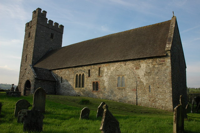
St Mary's Church, Llanfair-ar-y-bryn

St Mary's Church is a Church in Wales place of worship near Llandovery, Carmarthenshire, Wales. It was formerly the parish church of Llanfair-ar-y-bryn...

Alabum

The rectangular enclosure that defined this Roman fort was built in the 70s AD as part of the campaign to integrate southern Wales into the Roman province...

Nearby Amenities

Located within 500m of 52.016434,-3.8033284
Beiliglas
Place: farm
Lat/Long: 52.0149834/-3.8044163
Penrhiwrychen
Building: yes
Lat/Long: 52.0208479/-3.8027506
Direction: 145
Generator Method: photovoltaic
Generator Output Electricity: yes
Generator Solar Modules: 16
Generator Source: solar
Generator Type: solar_photovoltaic_panel
Location: roof
Power: generator
Lat/Long: 52.0208125/-3.802736
Power: pole
Lat/Long: 52.0139737/-3.7973857
Power: pole
Lat/Long: 52.013972/-3.798759
Power: pole
Lat/Long: 52.0139737/-3.7995797
Power: pole
Lat/Long: 52.0139737/-3.8010469
Power: pole
Lat/Long: 52.0139753/-3.8019991
Power: pole
Lat/Long: 52.0139786/-3.8031498
Power: pole
Transformer: distribution
Lat/Long: 52.0139803/-3.8046116
Power: pole
Lat/Long: 52.0191685/-3.808541
Power: pole
Lat/Long: 52.018571/-3.8078624
Power: pole
Lat/Long: 52.0175773/-3.8075754
Power: pole
Lat/Long: 52.0168757/-3.8073394
Power: pole
Lat/Long: 52.0163954/-3.8072133
Power: pole
Lat/Long: 52.0156691/-3.8069773
Power: pole
Lat/Long: 52.0146769/-3.8066313
Power: pole
Lat/Long: 52.0140067/-3.8062155
Power: pole
Lat/Long: 52.0132259/-3.8057166
Power: pole
Lat/Long: 52.0125738/-3.8053465
The data included in this document is from www.openstreetmap.org. The data is made available under ODbL.

Have you been to Allt Beili-glas?

Leave your review of Allt Beili-glas below (or comments, questions and feedback).