Coed Pendyffryn

Wood, Forest in Caernarfonshire

Wales

Coed Pendyffryn

Ysguborwen Road in Dwygyfylchi On the right is the Gladstone Bar & Grill.
Ysguborwen Road in Dwygyfylchi Credit: Mat Fascione

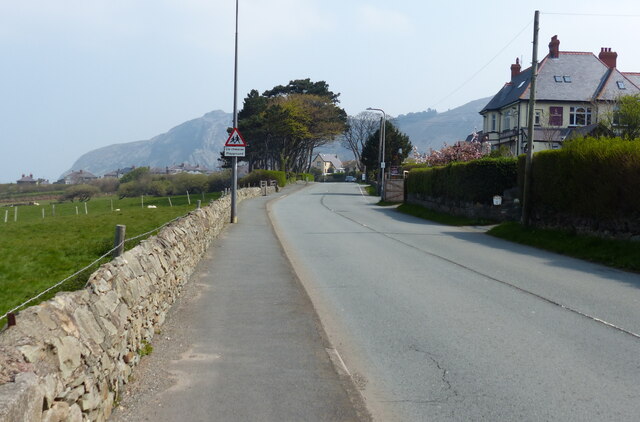
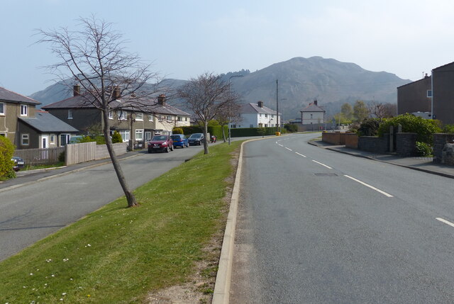
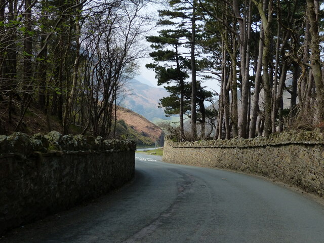
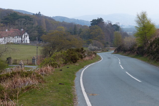
Coed Pendyffryn, located in Caernarfonshire, Wales, is a picturesque wood or forest that spans over a vast area. This natural haven is renowned for its stunning beauty and rich biodiversity. The wood is nestled within the majestic Snowdonia National Park, which adds to its allure and makes it a popular destination for nature enthusiasts.

The wood's landscape is diverse, comprising dense patches of deciduous and coniferous trees, rolling hills, and meandering streams. Visitors can expect to witness an array of vibrant colors throughout the year, from the lush greenery of spring and summer to the fiery hues of autumn. The wood's tranquil atmosphere is enhanced by the soothing sounds of birds chirping and leaves rustling in the gentle breeze.

Coed Pendyffryn is home to a wide range of plant and animal species, making it a haven for wildlife. Among the flourishing flora, visitors can find native trees like oak, birch, and beech, creating a harmonious blend of different textures and shades. The wood also boasts an abundance of wildlife, including red squirrels, deer, and a variety of bird species, making it a paradise for birdwatchers.

For those seeking outdoor activities, Coed Pendyffryn offers a network of well-maintained walking trails. These trails cater to different levels of difficulty, ensuring that there is something suitable for everyone. As visitors wander through the wood, they can revel in the tranquility of nature, breathe in the fresh air, and immerse themselves in the beauty of their surroundings.

Coed Pendyffryn, Caernarfonshire, is a true gem that captivates visitors with its breathtaking scenery, diverse flora and fauna, and serene atmosphere. It is a place where one can disconnect from the hustle and bustle of everyday life and reconnect with nature's wonders.

If you have any feedback on the listing, please let us know in the comments section below.

Coed Pendyffryn Images

Images are sourced within 2km of 53.281331/-3.8876529 or Grid Reference SH7477. Thanks to Geograph Open Source API. All images are credited.

Ysguborwen Road in Dwygyfylchi On the right is the Gladstone Bar & Grill.
Ysguborwen Road in Dwygyfylchi
On the right is the Gladstone Bar & Grill.
Houses along Ysguborwen Road in Dwygyfylchi
The parish church of St Gwynin and war memorial at Dwygyfylchi
Old Mill Road at Dwygyfylchi
Houses at the western end of the Sychnant Pass
Sheep and pasture near Dwygyfylchi
Road ascending the Sychnant Pass
Road descending the Sychnant Pass
Sychnant Pass near Capelulo
North Wales Path at the Sychnant Pass The North Wales Path is 60 miles long and connects Bangor to Prestatyn.
The western section is the more challenging, climbing onto moorlands below Moel Wnion, passing Aber Falls, and continuing below Foel Fras and Tal y Fan and then over Conwy Mountain with fine views along the coast and inland towards Snowdonia's peaks. The Great Orme and Llandudno are encircled to reach Colwyn Bay. The eastern section runs along or closer to the coast with much less ascent, passing Abergele and Rhyll to reach Prestatyn. It links with the Offa's Dyke Path National Trail, and the Clwydian Way, at Prestatyn.
North Wales Path at the Sychnant Pass
The North Wales Path is 60 miles long and connects Bangor to Prestatyn. The western section is the more challenging, climbing onto moorlands below Moel Wnion, passing Aber Falls, and continuing below Foel Fras and Tal y Fan and then over Conwy Mountain with fine views along the coast and inland towards Snowdonia's peaks. The Great Orme and Llandudno are encircled to reach Colwyn Bay. The eastern section runs along or closer to the coast with much less ascent, passing Abergele and Rhyll to reach Prestatyn. It links with the Offa's Dyke Path National Trail, and the Clwydian Way, at Prestatyn.
Road through the Sychnant Pass
Sychnant Pass Road towards Conwy On the left is the Sychnant Pass Country House Hotel.
Sychnant Pass Road towards Conwy
On the left is the Sychnant Pass Country House Hotel.
Sychnant Pass Road towards Conwy
Wales Coast Path towards Penmaen-bach Point The Wales Coast Path (Welsh: Llwybr Arfordir Cymru) is a long distance footpath which follows the whole of the coastline of Wales. It opened on 5 May 2012, and offers a 870 mile long route from Chepstow in the south to Queensferry in the north.
Wales is the first country in the world to provide a dedicated footpath along its entire coastline. The Path runs through eleven National Nature Reserves and other nature reserves, including those managed by The Wildlife Trusts or Royal Society for the Protection of Birds (RSPB).
Logo can be seen at<a href="https://www.geograph.org.uk/photo/3738617">SS0897 : Logo, Wales Coast Path</a>.
Website: <span class="nowrap"><a title="http://www.walescoastpath.gov.uk/default.aspx" rel="nofollow ugc noopener" href="http://www.walescoastpath.gov.uk/default.aspx">Link</a><img style="margin-left:2px;" alt="External link" title="External link - shift click to open in new window" src="https://s1.geograph.org.uk/img/external.png" width="10" height="10"/></span>
Wales Coast Path towards Penmaen-bach Point
The Wales Coast Path (Welsh: Llwybr Arfordir Cymru) is a long distance footpath which follows the whole of the coastline of Wales. It opened on 5 May 2012, and offers a 870 mile long route from Chepstow in the south to Queensferry in the north. Wales is the first country in the world to provide a dedicated footpath along its entire coastline. The Path runs through eleven National Nature Reserves and other nature reserves, including those managed by The Wildlife Trusts or Royal Society for the Protection of Birds (RSPB). Logo can be seen atSS0897 : Logo, Wales Coast Path. Website: LinkExternal link
Sand dunes along Conwy Sands Looking north across 3 miles of Conwy Bay towards Great Orme's Head.
Sand dunes along Conwy Sands
Looking north across 3 miles of Conwy Bay towards Great Orme's Head.
Seat and sculptures along the Wales Coast Path The sculptures are Llywelyn the Great, Thomas Telford and Margaret Williams.
In the background is Conwy Mountain.
Seat and sculptures along the Wales Coast Path
The sculptures are Llywelyn the Great, Thomas Telford and Margaret Williams. In the background is Conwy Mountain.
Conwy Sands near Penmaen-bach Point
Show me another place!

Coed Pendyffryn is located at Grid Ref: SH7477 (Lat: 53.281331, Lng: -3.8876529)

Unitary Authority: Conwy

Police Authority: North Wales

What 3 Words

///brave.jump.reclined. Near Penmaenmawr, Conwy

Nearby Locations

Alltwen Coed Pendyffryn

Related Wikis

Dwygyfylchi

Dwygyfylchi (Welsh: [dʊɨɡəˈvəlχi]) is a village in Conwy County Borough, Wales. It is part of the community of Penmaenmawr which has a population of 4...

Sychnant Pass

Sychnant Pass (Welsh: Bwlch Sychnant, "Dry-stream Pass") in Conwy County Borough, Wales, links Conwy to Penmaenmawr via Dwygyfylchi. Much of the pass is...

Mynydd y Dref

Mynydd y Dref (Welsh : "Mountain of the Town") or Conwy Mountain is a hilly area to the west of the town of Conwy, in North Wales. To the north it overlooks...

Castell Caer Seion

Castell Caer Seion is an Iron Age hillfort situated at the top of Conwy Mountain, in Conwy County, North Wales. It is unusual for the fact that the main...

Nearby Amenities

Located within 500m of 53.281331,-3.8876529
Motorway Junction
Dwygyfylchi
Ref: 16A
Lat/Long: 53.2846148/-3.8908368
Crossing
Crossing: unmarked
Crossing Markings: no
Lat/Long: 53.2837122/-3.8939815
Bus Stop
Bus: yes
Public Transport: platform
Lat/Long: 53.2796493/-3.8937987
Post Box
Collection Times: Mo-Fr 09:00; Sa 07:00
Operator: Royal Mail
Operator Wikidata: Q638098
Post Box Mounting: pier
Post Box Type: lamp
Ref: LL34 10D
Royal Cypher: EIIR
Royal Cypher Wikidata: Q33102113
Lat/Long: 53.2806424/-3.8933446
Bus Stop
Bus: yes
Public Transport: platform
Lat/Long: 53.2796918/-3.8931256
Traffic Signals
Traffic Signals Direction: forward
Lat/Long: 53.2852018/-3.8902477
Toilets
Lat/Long: 53.2809825/-3.8939513
Shower
Lat/Long: 53.2809862/-3.893915
Give Way
Direction: forward
Lat/Long: 53.2836793/-3.8938826
Barrier: cattle_grid
Lat/Long: 53.2831553/-3.8919043
Give Way
Direction: forward
Lat/Long: 53.2841112/-3.8920019
Communication Lte: yes
Communication Mobile Phone: yes
Man Made: mast
Operator: EE
Operator Wikidata: Q5322942
Tower Construction: monopole
Tower Type: communication
Lat/Long: 53.2855178/-3.8897797
The data included in this document is from www.openstreetmap.org. The data is made available under ODbL.

Have you been to Coed Pendyffryn?

Leave your review of Coed Pendyffryn below (or comments, questions and feedback).