Burrowbridge

Settlement in Somerset Somerset West and Taunton

England

Burrowbridge

Road and track going up to the river
Road and track going up to the river Credit: Rob Purvis

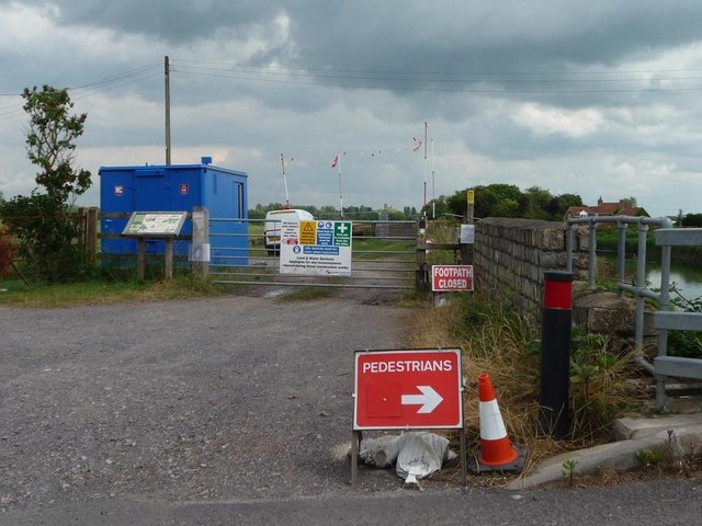
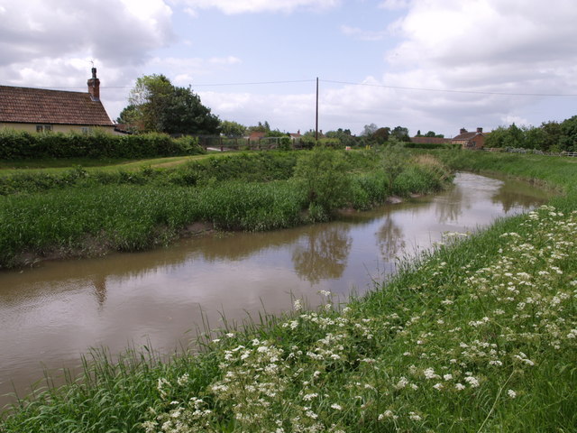
Burrowbridge is a village located in the county of Somerset, England. Situated on the banks of the River Parrett, it lies approximately 6 miles west of the town of Bridgwater. The village is a part of the Sedgemoor district and falls within the parliamentary constituency of Bridgwater and West Somerset.

The history of Burrowbridge can be traced back to the Roman period, with evidence of Roman settlements found in the area. The village takes its name from the Old English word "burh," meaning fort or fortified place, suggesting the presence of a defensive structure in ancient times.

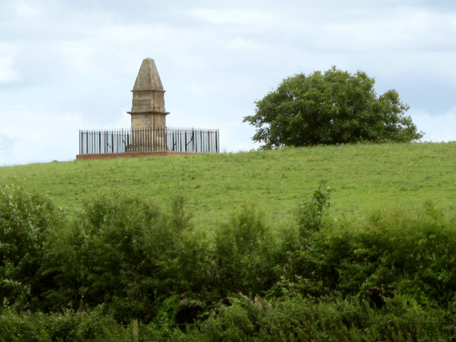
One of the notable landmarks in Burrowbridge is the Burrow Mump, a natural hill that rises above the flat Somerset Levels. This iconic landmark is crowned by the ruined remains of a 15th-century church, St. Michael's. It provides panoramic views of the surrounding countryside and is a popular destination for walkers and nature enthusiasts.

The village is also known for its connection to the Somerset Levels and Moors, a unique wetland area renowned for its rich biodiversity. The area attracts a variety of bird species, making it a popular spot for birdwatching.

Burrowbridge is a small, close-knit community with a population of around 500 residents. It has a primary school, a village hall, and a local pub, providing essential amenities for its residents. The village is well-connected to neighboring towns and cities through road links, with the A361 passing nearby.

Overall, Burrowbridge offers a picturesque setting, rich history, and close proximity to natural beauty, making it an appealing place to live or visit for those seeking a tranquil rural retreat.

If you have any feedback on the listing, please let us know in the comments section below.

Burrowbridge Images

Images are sourced within 2km of 51.070051/-2.918688 or Grid Reference ST3530. Thanks to Geograph Open Source API. All images are credited.

Road and track going up to the river
Stan Moor The view from the train of some of the flat land at Stan Moor, part of the Somerset Levels.  All those lines are drainage ditches.  On the left horizon is Burrow Mount in <a href="https://www.geograph.org.uk/gridref/ST3530">ST3530</a>
This photo was taken from the 1158 Penzance to London Paddington train, having left Taunton at 1529.
Stan Moor
The view from the train of some of the flat land at Stan Moor, part of the Somerset Levels. All those lines are drainage ditches. On the left horizon is Burrow Mount in ST3530 This photo was taken from the 1158 Penzance to London Paddington train, having left Taunton at 1529.
Athelney Farm and King Alfred's Monument
Cuts Road, Athelney
Cuts Road, Athelney
Stanmoor Pumping Station Built in 1947, now run by the Environment Agency. Part of the complex system of drainage within the Somerset Levels.
Stanmoor Pumping Station
Built in 1947, now run by the Environment Agency. Part of the complex system of drainage within the Somerset Levels.
River Tone and Stanmoor Bank The floodbank was built between 1254 and 1375, to reduce flooding on Stan Moor.. It was raised higher in 2001.
River Tone and Stanmoor Bank
The floodbank was built between 1254 and 1375, to reduce flooding on Stan Moor.. It was raised higher in 2001.
Footpath closed, pedestrians diverted at Athelney Site entrance to dredging works on the River Tone.
Footpath closed, pedestrians diverted at Athelney
Site entrance to dredging works on the River Tone.
Dredged River Tone at Athelney A response to the immense flooding early in 2014.
Dredged River Tone at Athelney
A response to the immense flooding early in 2014.
Cuts Road, Athelney A typical moors road passes the site of Alfred's hideout from the Danes.
Cuts Road, Athelney
A typical moors road passes the site of Alfred's hideout from the Danes.
River Tone, Athelney Evidence of some of the dredging and drainage work taking place in response to the flooding of 2014.  The river is tidal here.
River Tone, Athelney
Evidence of some of the dredging and drainage work taking place in response to the flooding of 2014. The river is tidal here.
Stanmoor A rhyne, Athelney.
Stanmoor
A rhyne, Athelney.
Athelney
Athelney
Road, Stanmoor Moors road with a rhyne running beside it. There is higher ground on the left, some of which is occupied.
Road, Stanmoor
Moors road with a rhyne running beside it. There is higher ground on the left, some of which is occupied.
Stanmoor Greening up pasture on the moors beside the River Tone.
Stanmoor
Greening up pasture on the moors beside the River Tone.
Road to Stathe The road by Burrowbridge has a rhyne on one side and houses on the other. Behind the house is the River Parrett, near to its confluence with the Tone.  Like many rhynes after the great floods, this one has been recently dredged.
Road to Stathe
The road by Burrowbridge has a rhyne on one side and houses on the other. Behind the house is the River Parrett, near to its confluence with the Tone. Like many rhynes after the great floods, this one has been recently dredged.
Houses and cyclist at Athelney
Fields near Burrowbridge
Burrow Mump A ruined church in the Somerset Levels. The site of a battle on 13th July 1645. The Royalists lost. There were attempts to restore it in the 18th century. The last attempt turned it into a fashionable folly.
Burrow Mump
A ruined church in the Somerset Levels. The site of a battle on 13th July 1645. The Royalists lost. There were attempts to restore it in the 18th century. The last attempt turned it into a fashionable folly.
Show me another place!

Burrowbridge is located at Grid Ref: ST3530 (Lat: 51.070051, Lng: -2.918688)

Administrative County: Somerset

District: Somerset West and Taunton

Police Authority: Avon and Somerset

What 3 Words

///dazzling.blatantly.gathers. Near Westonzoyland, Somerset

Nearby Locations

Burrow Mump Burrowbridge

Related Wikis

Burrowbridge

Burrowbridge is a village and civil parish in Somerset, England, situated on the River Parrett and the A361 road on the edge of the Somerset Levels. It...

Burrow Mump

Burrow Mump is a hill and historic site overlooking Southlake Moor in the village of Burrowbridge within the English county of Somerset. It is a scheduled...

River Tone

The River Tone is a river in the English county of Somerset. The river is about 33 kilometres (21 mi) long. Its source is at Beverton Pond near Huish Champflower...

Southlake Moor

Southlake Moor (grid reference ST370300) is a 196.1 hectare (484.6 acre) biological Site of Special Scientific Interest near Burrow Mump and Burrowbridge...

Athelney Abbey

Athelney Abbey, established in the county of Somerset, England, was founded by King Alfred in 888, as a religious house for monks of the Order of St....

Athelney

Athelney is a village located between the villages of Burrowbridge and East Lyng in the Sedgemoor district of Somerset, England. The name is believed to...

Balt Moor Wall

Balt Moor Wall is an earthwork and listed scheduled ancient monument in Lyng, Somerset, England, situated on the Somerset Levels to the northwest of the...

Langmead and Weston Level

Langmead and Weston Level (grid reference ST353330) is a 168.8 hectare (417.1 acre) biological Site of Special Scientific Interest in Somerset, notified...

Nearby Amenities

Located within 500m of 51.070051,-2.918688
Burrowbridge
Is In: Somerset, England, UK
Place: village
Wikidata: Q3622474
Wikipedia: en:Burrowbridge
Lat/Long: 51.0699223/-2.9182684
Stop
Lat/Long: 51.0703078/-2.9178659
Traffic Signals
Lat/Long: 51.0694178/-2.9189183
Traffic Signals
Lat/Long: 51.0697917/-2.9183025
Traffic Signals
Lat/Long: 51.0699434/-2.9180259
Give Way
Direction: backward
Lat/Long: 51.0692597/-2.9190919
Give Way
Direction: forward
Lat/Long: 51.0693213/-2.9191741
Public Bookcase
Burrowbridge Parish Library
Booth: K6
Colour: red
Covered: booth
Disused Amenity: telephone
Man Made: telephone_box
Public Bookcase Type: phone_box
Lat/Long: 51.0695401/-2.9186067
Post Box
Brand: Royal Mail
Brand Wikidata: Q638098
Brand Wikipedia: en:Royal Mail
Operator: Royal Mail
Operator Wikidata: Q638098
Post Box Type: wall
Ref: TA7 200
Royal Cypher: EIIR
Royal Cypher Wikidata: Q33102113
Lat/Long: 51.0698408/-2.9180174
Give Way
Lat/Long: 51.0667296/-2.9173873
Board Type: history
Information: board
Tourism: information
Lat/Long: 51.0695231/-2.9186091
Burrow Mump
Ele: 24
Natural: peak
Lat/Long: 51.0704894/-2.9160617
The data included in this document is from www.openstreetmap.org. The data is made available under ODbL.

Have you been to Burrowbridge?

Leave your review of Burrowbridge below (or comments, questions and feedback).