Burntcommon

Settlement in Surrey Guildford

England

Burntcommon

Something pink in a field On a hillside behind the houses at Three Fords is a crop of something with pink flowers. Too far away to say what it is. Maybe wild flowers, sanfoin or something like that.
Something pink in a field Credit: Des Blenkinsopp

Burntcommon is a small village located in the county of Surrey, England. Situated approximately 30 miles southwest of London, it falls within the borough of Guildford. The village is nestled amidst the picturesque Surrey Hills, a designated Area of Outstanding Natural Beauty, offering residents and visitors a stunning rural setting.

Burntcommon is known for its tranquil and idyllic atmosphere, making it a desirable place to live for those seeking a peaceful countryside lifestyle within easy reach of urban amenities. The village is predominantly residential, with a mix of traditional cottages and modern houses, all surrounded by lush green fields and woodland.

Despite its small size, Burntcommon benefits from a few local amenities. There is a quaint village shop that caters to the daily needs of residents, offering a selection of groceries and household items. Additionally, a charming pub serves as a social hub for the community, providing a place to relax and enjoy a drink or a meal.

The village is well-connected, with easy access to major road networks such as the A3 and M25, providing convenient links to nearby towns and cities. Train services are available from nearby stations, including Woking and Guildford, offering direct routes to London and other destinations.

Surrounded by natural beauty, Burntcommon offers ample opportunities for outdoor activities and exploration. The Surrey Hills provide a stunning backdrop for hiking, cycling, and horse riding, with numerous trails and bridleways to discover. Overall, Burntcommon is a charming village that offers a peaceful countryside lifestyle, making it an attractive place to call home.

If you have any feedback on the listing, please let us know in the comments section below.
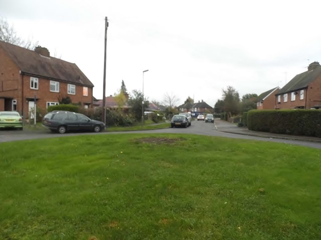
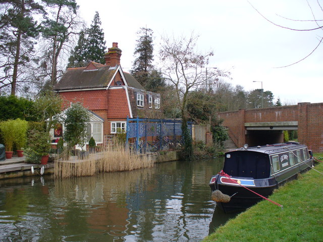
Burntcommon Images

Images are sourced within 2km of 51.28359/-0.508713 or Grid Reference TQ0454. Thanks to Geograph Open Source API. All images are credited.

Something pink in a field On a hillside behind the houses at Three Fords is a crop of something with pink flowers. Too far away to say what it is. Maybe wild flowers, sanfoin or something like that.
Something pink in a field
On a hillside behind the houses at Three Fords is a crop of something with pink flowers. Too far away to say what it is. Maybe wild flowers, sanfoin or something like that.
Georgelands, Ripley There was a large tree on this roundabout in 2012 and is now gone
Georgelands, Ripley
There was a large tree on this roundabout in 2012 and is now gone
Georgelands, Ripley
Georgelands, Ripley
Private road to houses, Pyrford
The Jovial Sailor public house
Along the Broadmead Cut in November Photo taken on November 11th, and for the moment the picture is still quite green.  The leaning tree on the near bank is an alder (and a pretty typical specimen); on the far bank alders mingle with oaks.
Along the Broadmead Cut in November
Photo taken on November 11th, and for the moment the picture is still quite green. The leaning tree on the near bank is an alder (and a pretty typical specimen); on the far bank alders mingle with oaks.
Broadmead Cut in November: the view from the Tanyard Bridge Looking downstream (north-east) from the bridge.

<a href="https://www.geograph.org.uk/photo/3902231">TQ0256 : Broadmead Cut in March</a> and <a href="https://www.geograph.org.uk/photo/3407827">TQ0256 : Broadmead Cut: view north-east from the Tanyard Bridge in early April</a> were taken from much the same spot, but at times of year when the trees were leafless.
Broadmead Cut in November: the view from the Tanyard Bridge
Looking downstream (north-east) from the bridge. TQ0256 : Broadmead Cut in March and TQ0256 : Broadmead Cut: view north-east from the Tanyard Bridge in early April were taken from much the same spot, but at times of year when the trees were leafless.
Farmland south of the Tannery site, November The stubble in the foreground is the remains of a maize crop.  I heard locally that this stretch of farmland is reckoned to be of poor quality.  In the past there were gravel pits here, the present topsoil having been brought in from elsewhere.
Farmland south of the Tannery site, November
The stubble in the foreground is the remains of a maize crop. I heard locally that this stretch of farmland is reckoned to be of poor quality. In the past there were gravel pits here, the present topsoil having been brought in from elsewhere.
Papercourt Sailing Club
Homewood Farm Cottages, Newark Lane
The Manor House Grade II listed <span class="nowrap"><a title="https://www.historicengland.org.uk/listing/the-list/list-entry/1029348" rel="nofollow ugc noopener" href="https://www.historicengland.org.uk/listing/the-list/list-entry/1029348">Link</a><img style="margin-left:2px;" alt="External link" title="External link - shift click to open in new window" src="https://s1.geograph.org.uk/img/external.png" width="10" height="10"/></span>
The Manor House
Grade II listed LinkExternal link
Arch by The Street, West Clandon Leading to a path
Arch by The Street, West Clandon
Leading to a path
Path off The Street, West Clandon
Trees on the corner of Lime Grove and The Street
Path entrance on The Street, West Clandon
The Street, West Clandon
Lime Grove, West Clandon
Send Marsh Green
Send Marsh Green
Show me another place!

Burntcommon is located at Grid Ref: TQ0454 (Lat: 51.28359, Lng: -0.508713)

Administrative County: Surrey

District: Guildford

Police Authority: Surrey

What 3 Words

///shut.music.latest. Near Send, Surrey

Nearby Locations

Oldlands Copse Burntcommon

Related Wikis

Send, Surrey

Send is a village and civil parish in the Guildford borough of the English county of Surrey. The name is thought to mean "sandy place" and sand was extracted...

HM Prison Send

HM Prison Send is a closed category women's prison in the extreme south of Ripley nearer Send in Surrey, England. Its post town is Woking. The prison...

Papercourt Marshes

Papercourt Marshes is a 10-hectare (25-acre) nature reserve in the borough of Guildford in Surrey. It is managed by the Surrey Wildlife Trust. A roughly...

North Downs

The North Downs are a ridge of chalk hills in south east England that stretch from Farnham in Surrey to the White Cliffs of Dover in Kent. Much of the...

Nearby Amenities

Located within 500m of 51.28359,-0.508713
Crossing
Bicycle: yes
Crossing: unmarked
Kerb: lowered
Sloped Curb: yes
Lat/Long: 51.2815635/-0.5146432
Power: tower
Lat/Long: 51.2812853/-0.5079637
Power: tower
Lat/Long: 51.2856793/-0.5034144
Mini Roundabout
Lat/Long: 51.285718/-0.5107491
Turning Circle
Source: Surrey_Aerial
Lat/Long: 51.2879304/-0.5080966
Power: tower
Lat/Long: 51.2871472/-0.5045877
Crossing
Bicycle: yes
Crossing: unmarked
Kerb: lowered
Sloped Curb: yes
Lat/Long: 51.2817027/-0.5148374
Burnt Common
Place: locality
Source: npe
Lat/Long: 51.2835957/-0.5108735
Bus Stop
Send Marsh Road
Naptan AtcoCode: 40004407236B
Naptan Bearing: SW
Naptan CommonName: Send Marsh Road
Naptan Indicator: Opp
Naptan Landmark: Portsmouth Road / Send Marsh Road
Naptan NaptanCode: surapmpa
Naptan Street: Portsmouth Road
Naptan Verified: no
Public Transport: platform
Source: naptan_import
Lat/Long: 51.2868951/-0.5054338
Bus Stop
Burnt Common Lane
Naptan AtcoCode: 40004407237A
Naptan Bearing: NE
Naptan CommonName: Burnt Common Lane
Naptan Indicator: Opp
Naptan Landmark: Burnt Common Lane
Naptan NaptanCode: surapmpg
Naptan Street: Portsmouth Road
Naptan Verified: no
Public Transport: platform
Source: naptan_import
Lat/Long: 51.2842381/-0.5093045
Bus Stop
Burnt Common Lane
Naptan AtcoCode: 40004407237B
Naptan Bearing: SW
Naptan CommonName: Burnt Common Lane
Naptan Indicator: Just Before
Naptan Landmark: Burnt Common Lane
Naptan NaptanCode: surapmpj
Naptan Street: Portsmouth Road
Naptan Verified: no
Public Transport: platform
Source: naptan_import
Lat/Long: 51.2846407/-0.5084021
Bus Stop
Burnt Common Roundabout
Naptan AtcoCode: 40004407238A
Naptan Bearing: NW
Naptan CommonName: Burnt Common Roundabout
Naptan Indicator: Just after
Naptan Landmark: Burnt Common Roundabout / Send Barns Lane
Naptan NaptanCode: surapmpm
Naptan Street: Send Barns Lane
Naptan Verified: no
Public Transport: platform
Source: naptan_import
Lat/Long: 51.2823756/-0.5154947
Bus Stop
Burnt Common Roundabout
Bus: yes
Naptan AtcoCode: 40004407238B
Naptan Bearing: SE
Naptan CommonName: Burnt Common Roundabout
Naptan Indicator: Just Before
Naptan Landmark: Burnt Common Roundabout
Naptan NaptanCode: surapmpt
Naptan Street: Send Barns Lane
Naptan Verified: no
Public Transport: platform
Source: naptan_import
Lat/Long: 51.282306/-0.51513
Tithebarns Lane
Naptan AtcoCode: 40004407252B
Naptan Bearing: S
Naptan CommonName: Tithebarns Lane
Naptan Indicator: Just Before
Naptan Landmark: A3 Bridge
Naptan NaptanCode: suraptdt
Naptan Street: Clandon Road
Naptan Verified: no
Source: naptan_import
Lat/Long: 51.2799832/-0.5104846
Bus Stop
Burnt Common Roundabout
Bench: yes
Bin: yes
Naptan AtcoCode: 40004407403B
Naptan Bearing: SE
Naptan CommonName: Burnt Common Roundabout
Naptan Indicator: Nr
Naptan Landmark: Burnt Common Roundabout
Naptan NaptanCode: suratjaw
Naptan Street: Clandon Road
Naptan Verified: no
Public Transport: platform
Shelter: yes
Source: naptan_import
Lat/Long: 51.2811273/-0.512774
Bus Stop
Burnt Common Roundabout
Bus: yes
Naptan AtcoCode: 40004407403C
Naptan Bearing: NE
Naptan CommonName: Burnt Common Roundabout
Naptan Indicator: Opp
Naptan Landmark: Burnt Common Roundabout
Naptan NaptanCode: suratjda
Naptan Street: Portsmouth Road
Naptan Verified: no
Public Transport: platform
Source: naptan_import
Lat/Long: 51.2822608/-0.5135553
Crossing
Crossing: unmarked
Crossing Island: yes
Kerb: lowered
Sloped Curb: yes
Source: DigitalGlobe-Standard
Lat/Long: 51.2837314/-0.5099942
Crossing
Bicycle: yes
Crossing: unmarked
Kerb: lowered
Sloped Curb: yes
Lat/Long: 51.2816328/-0.5141357
Crossing
Bicycle: yes
Crossing: unmarked
Kerb: lowered
Sloped Curb: yes
Lat/Long: 51.2816835/-0.5140596
Fuel
Send Shell Petrol Station
Addr Postcode: GU23 7JY
Brand: Shell
Brand Wikidata: Q110716465
Fuel Diesel: yes
Fuel Octane 95: yes
Fuel Octane 98: yes
Opening Hours: Mo-Su 07:00-22:00
Operator: Royal Dutch Shell
Payment App: yes
Payment Cards: yes
Payment Cash: yes
Payment Contactless: yes
Phone: +44 1483 223469
Ref Navads: NVDS353_10019487
Self Service: yes
Website: https://find.shell.com/gb/fuel/10019487-shell-little-waitrose-burnt-common
Wheelchair: yes
Lat/Long: 51.2818536/-0.5133765
Addr Housenumber: 1
Addr Postcode: GU23 6BN
Addr Street: The Copse
Source Addr: Land Registry Prices Paid Open Data
Lat/Long: 51.2855078/-0.5122577
Addr Housenumber: 1
Addr Postcode: GU23 6BN
Addr Street: The Copse
Source Addr: Land Registry Prices Paid Open Data
Lat/Long: 51.2855413/-0.5121745
Addr Housenumber: 1
Addr Postcode: GU23 6BN
Addr Street: The Copse
Source Addr: Land Registry Prices Paid Open Data
Lat/Long: 51.2855866/-0.5120297
Addr Housenumber: 10
Addr Postcode: GU23 6BN
Addr Street: The Copse
Source Addr: Land Registry Prices Paid Open Data
Lat/Long: 51.2852192/-0.512086
Addr Housenumber: 12
Addr Postcode: GU23 6BN
Addr Street: The Copse
Source Addr: Land Registry Prices Paid Open Data
Lat/Long: 51.2850649/-0.5119707
Addr Housenumber: 8
Addr Postcode: GU23 6BN
Addr Street: The Copse
Source Addr: Land Registry Prices Paid Open Data
Lat/Long: 51.28535/-0.5121504
Addr Housenumber: 1
Addr Postcode: GU23 6BN
Addr Street: The Copse
Source Addr: Land Registry Prices Paid Open Data
Lat/Long: 51.2856872/-0.5118715
Addr Housenumber: 9
Addr Postcode: GU23 6BN
Addr Street: The Copse
Source Addr: Land Registry Prices Paid Open Data
Lat/Long: 51.2853115/-0.5121102
Addr Housenumber: 1
Addr Postcode: GU23 6BN
Addr Street: The Copse
Source Addr: Land Registry Prices Paid Open Data
Lat/Long: 51.2856118/-0.5119573
Addr Housenumber: 1
Addr Postcode: GU23 6BN
Addr Street: The Copse
Source Addr: Land Registry Prices Paid Open Data
Lat/Long: 51.2857426/-0.5117508
Addr Housenumber: 11
Addr Postcode: GU23 6BN
Addr Street: The Copse
Source Addr: Land Registry Prices Paid Open Data
Lat/Long: 51.2851572/-0.5120431
Crossing
Bicycle: yes
Crossing: unmarked
Kerb: lowered
Sloped Curb: yes
Lat/Long: 51.2819352/-0.5147258
Crossing
Bicycle: yes
Crossing: unmarked
Kerb: lowered
Sloped Curb: yes
Lat/Long: 51.2824182/-0.5152506
Crossing
Bicycle: yes
Crossing: unmarked
Kerb: lowered
Sloped Curb: yes
Lat/Long: 51.2818452/-0.5140626
Crossing
Bicycle: yes
Crossing: unmarked
Kerb: lowered
Sloped Curb: yes
Lat/Long: 51.2819664/-0.5141797
Crossing
Bicycle: yes
Crossing: unmarked
Kerb: lowered
Sloped Curb: yes
Lat/Long: 51.2819753/-0.5146263
Crossing
Crossing: unmarked
Crossing Markings: no
Kerb: lowered
Source: DigitalGlobe-Standard
Lat/Long: 51.2821286/-0.5132262
Crossing
Crossing: unmarked
Crossing Markings: no
Kerb: lowered
Source: DigitalGlobe-Standard
Lat/Long: 51.281935/-0.5136756
Crossing
Crossing: unmarked
Crossing Island: yes
Kerb: lowered
Sloped Curb: yes
Source: DigitalGlobe-Standard
Lat/Long: 51.2870618/-0.5053095
Little Waitrose
Addr City: Send
Addr Country: GB
Addr Postcode: GU23 7JY
Addr Street: Portsmouth Road
Brand: Waitrose & Partners
Brand Wikidata: Q771734
Brand Wikipedia: en:Waitrose & Partners
Fhrs Authority: Guildford
Fhrs Id: 649913
Fhrs Local Authority Id: 4678
Shop: supermarket
Website: https://www.waitrose.com/find-a-store/burnt-common
Lat/Long: 51.2817198/-0.513537
Generator Method: photovoltaic
Generator Output Electricity: yes
Generator Source: solar
Generator Type: solar_photovoltaic_panel
Location: roof
Power: generator
Lat/Long: 51.2860463/-0.5076719
Post Box
Check Date Collection Times: 2021-11-06
Collection Plate: CP1D
Collection Times: Mo-Fr 09:00; Sa 07:00
Operator: Royal Mail
Operator Wikidata: Q638098
Post Box Mounting: brick_pillar
Post Box Type: wall
Ref: GU23 121D
Royal Cypher: EIIR
Royal Cypher Wikidata: Q33102113
Lat/Long: 51.2824815/-0.5131068
Post Box
Brand: Royal Mail
Brand Wikidata: Q638098
Brand Wikipedia: en:Royal Mail
Collection Plate: CP7D
Collection Times: Mo-Fr 09:00; Sa 07:00
Last Checked: 2022-02-15
Operator: Royal Mail
Operator Wikidata: Q638098
Post Box Mounting: wooden_post
Post Box Type: lamp
Ref: GU23 88D
Royal Cypher: EIIR
Royal Cypher Wikidata: Q33102113
Source: survey
Lat/Long: 51.2802727/-0.510814
Historic: milestone
Inscription: HYDE PARK CORNER 23 PORTSMOUTH 46 GUILDFORD 4 MILES RIPLEY 2 MILES
Ref: SY_LP23
Ref GB Milestoneid: SY_LP23
Lat/Long: 51.2824666/-0.5124767
Traffic Calming: island
Lat/Long: 51.2824429/-0.5127538
The data included in this document is from www.openstreetmap.org. The data is made available under ODbL.

Have you been to Burntcommon?

Leave your review of Burntcommon below (or comments, questions and feedback).