Allt Rhosgelli

Wood, Forest in Cardiganshire

Wales

Allt Rhosgelli

Tafarn y Vale/Vale of Aeron Public house on the A482 at Ystrad Aeron, a local pub which has been bought by the community
Tafarn y Vale/Vale of Aeron Credit: Eirian Evans

Allt Rhosgelli, located in Cardiganshire, is a picturesque wood or forest that spans across a significant area. The wood is nestled in a valley, surrounded by rolling hills and stunning natural beauty. It offers a tranquil escape for nature lovers and those seeking a peaceful retreat.

The wood is home to a diverse range of flora and fauna, showcasing the rich biodiversity of the region. The dense canopy of trees provides a perfect habitat for various bird species, making it a popular destination for birdwatchers. Visitors may spot species such as woodpeckers, owls, and songbirds.

Walking through Allt Rhosgelli is a delight for hikers and nature enthusiasts. The wood features well-maintained trails that wind through the towering trees, offering breathtaking views of the surrounding landscape. The enchanting atmosphere evokes a sense of serenity and calmness.

The wood also holds historical significance, as it was once part of an ancient forest that covered large parts of Cardiganshire. Remnants of this ancient woodland can still be seen, adding a touch of mystery and intrigue to the area.

Allt Rhosgelli is accessible to the public, and visitors can explore the wood at their own pace. It is a popular spot for picnics, photography, and simply immersing oneself in the wonders of nature. Whether it's the vibrant colors of autumn leaves or the vibrant birdlife, Allt Rhosgelli offers a truly unforgettable experience for all who visit.

If you have any feedback on the listing, please let us know in the comments section below.

Allt Rhosgelli Images

Images are sourced within 2km of 52.191795/-4.177025 or Grid Reference SN5157. Thanks to Geograph Open Source API. All images are credited.

Tafarn y Vale/Vale of Aeron Public house on the A482 at Ystrad Aeron, a local pub which has been bought by the community
Tafarn y Vale/Vale of Aeron
Public house on the A482 at Ystrad Aeron, a local pub which has been bought by the community
Neuadd Goffa Felinfach Memorial Hall Based in the Centre of Lampeter Village, the hall was built in 1927 and refurbished in 2008.
Neuadd Goffa Felinfach Memorial Hall
Based in the Centre of Lampeter Village, the hall was built in 1927 and refurbished in 2008.
Overhanging trees near Hampton On minor road heading south from Ty Nant
Overhanging trees near Hampton
On minor road heading south from Ty Nant
Ordnance Survey Flush Bracket 12004 This can be found on the wall of Felinfach Theatre at Ystrad Aeron College.
For more detail see : <span class="nowrap"><a title="http://www.bench-marks.org.uk/bm22713" rel="nofollow ugc noopener" href="http://www.bench-marks.org.uk/bm22713">Link</a><img style="margin-left:2px;" alt="External link" title="External link - shift click to open in new window" src="https://s1.geograph.org.uk/img/external.png" width="10" height="10"/></span>
Ordnance Survey Flush Bracket 12004
This can be found on the wall of Felinfach Theatre at Ystrad Aeron College. For more detail see : LinkExternal link
Afon Aeron valley west of Ystrad Aeron, 1994 View eastward about a mile from Ystrad on the B4342 road from Dihewyd, to the Cambrian Mountains in the distance.
Afon Aeron valley west of Ystrad Aeron, 1994
View eastward about a mile from Ystrad on the B4342 road from Dihewyd, to the Cambrian Mountains in the distance.
Milestone - Aberayron 5 There is an OS rivet on the top of the milestone. <a title="https://www.geograph.org.uk/photo/4890310" href="https://www.geograph.org.uk/photo/4890310">Link</a>
Milestone - Aberayron 5
There is an OS rivet on the top of the milestone. Link
Ordnance Survey Rivet This OS rivet can be found on the milestone. It marks a point 71.232m above mean sea level. <a title="https://www.geograph.org.uk/photo/4890306" href="https://www.geograph.org.uk/photo/4890306">Link</a>
Ordnance Survey Rivet
This OS rivet can be found on the milestone. It marks a point 71.232m above mean sea level. Link
Milestone - Aberayron 6 There is an OS cut mark on the front. It marks a point 80.8390m above mean sea level.
Milestone - Aberayron 6
There is an OS cut mark on the front. It marks a point 80.8390m above mean sea level.
Across the Aeron Valley in Ceredigion Seen from the byway between Tal-sarn and Gwynog, looking across land near Cilbwn farm - and across the Aeron Valley near Ystrad Aeron.
Across the Aeron Valley in Ceredigion
Seen from the byway between Tal-sarn and Gwynog, looking across land near Cilbwn farm - and across the Aeron Valley near Ystrad Aeron.
Entrance to lane to Bwlch-y-person and Pencaelyfri
Ystrad Aeron, at the junction of the B4342 with the A482
Old Milestone by the A482, Ystrad Aeron, Llanfihangel Ystrad Parish Aberayron tombstone by the A482, in parish of Llanfihangel Ystrad (Ceredigion District), Ystrad Aeron, at entrance to Felin Fach Theatre.

Inscription reads:-
ABERAYRON
6
Miles
Lampeter
(7)

Grade II listed by Cadw. Reference Number: 17432
<span class="nowrap"><a title="https://cadwpublic-api.azurewebsites.net/reports/listedbuilding/FullReport?lang=&id=17432" rel="nofollow ugc noopener" href="https://cadwpublic-api.azurewebsites.net/reports/listedbuilding/FullReport?lang=&id=17432">Link</a><img style="margin-left:2px;" alt="External link" title="External link - shift click to open in new window" src="https://s1.geograph.org.uk/img/external.png" width="10" height="10"/></span>

Surveyed

Milestone Society National ID: CRD_AALP06
Old Milestone by the A482, Ystrad Aeron, Llanfihangel Ystrad Parish
Aberayron tombstone by the A482, in parish of Llanfihangel Ystrad (Ceredigion District), Ystrad Aeron, at entrance to Felin Fach Theatre. Inscription reads:- ABERAYRON 6 Miles Lampeter (7) Grade II listed by Cadw. Reference Number: 17432 LinkExternal link Surveyed Milestone Society National ID: CRD_AALP06
Old Milestone by the A482, Ciliau Aeron parish Aberayron tombstone by the A482, in parish of Ciliau Aeron (Ceredigion District), Ciliau Aeron, near Tan-yr-allt, East side of road.

Inscription reads:-
ABERAYRON
5
MILES
LAMPETER
8
Carved bench mark and rivet on top.

Grade II listed by Cadw.
Reference Number: 17524 <span class="nowrap"><a title="https://cadwpublic-api.azurewebsites.net/reports/listedbuilding/FullReport?lang=&id=17524" rel="nofollow ugc noopener" href="https://cadwpublic-api.azurewebsites.net/reports/listedbuilding/FullReport?lang=&id=17524">Link</a><img style="margin-left:2px;" alt="External link" title="External link - shift click to open in new window" src="https://s1.geograph.org.uk/img/external.png" width="10" height="10"/></span>

Surveyed

Milestone Society National ID: CRD_AALP05
Old Milestone by the A482, Ciliau Aeron parish
Aberayron tombstone by the A482, in parish of Ciliau Aeron (Ceredigion District), Ciliau Aeron, near Tan-yr-allt, East side of road. Inscription reads:- ABERAYRON 5 MILES LAMPETER 8 Carved bench mark and rivet on top. Grade II listed by Cadw. Reference Number: 17524 LinkExternal link Surveyed Milestone Society National ID: CRD_AALP05
Llwybr Blaen Berllan / Blaen Berllan Path Cerddwyr yn dilyn llwybr cyhoeddus i gyfeiriad Ffarm Blaen Berllan.

Walkers following a public footpath in the direction of Blaen Berllan Farm (trans. source of the orchard [stream]).
Llwybr Blaen Berllan / Blaen Berllan Path
Cerddwyr yn dilyn llwybr cyhoeddus i gyfeiriad Ffarm Blaen Berllan. Walkers following a public footpath in the direction of Blaen Berllan Farm (trans. source of the orchard [stream]).
Perthi Bach Cerddwyr yn mynd heibio i anhedd-dy o'r enw Perthi Bach.

Walkers passing a property known as Perthi Bach (trans. little hedges).
Perthi Bach
Cerddwyr yn mynd heibio i anhedd-dy o'r enw Perthi Bach. Walkers passing a property known as Perthi Bach (trans. little hedges).
Trac coedwigoedd Allt Ty Mawr / Allt Ty Mawr forestry track Cerddwyr yn dilyn trac coedwigoedd yn Allt Ty Mawr.

Walkers following a forestry track at Allt Ty Mawr (trans. big house wooded hill).
Trac coedwigoedd Allt Ty Mawr / Allt Ty Mawr forestry track
Cerddwyr yn dilyn trac coedwigoedd yn Allt Ty Mawr. Walkers following a forestry track at Allt Ty Mawr (trans. big house wooded hill).
Trac coedwigoedd Allt Ty Mawr  / Allt Ty Mawr forestry track Cerddwyr yn dilyn trac coedwigoedd yn Allt Ty Mawr.

Walkers following a forestry track at Allt Ty Mawr (trans. big house wooded hill).
Trac coedwigoedd Allt Ty Mawr / Allt Ty Mawr forestry track
Cerddwyr yn dilyn trac coedwigoedd yn Allt Ty Mawr. Walkers following a forestry track at Allt Ty Mawr (trans. big house wooded hill).
Pomprenni / Footbridges Cerddwyr yn croesi pomprenni ar lan Afon Aeron.

Walkers crossing footbridges above the Aeron River.
Pomprenni / Footbridges
Cerddwyr yn croesi pomprenni ar lan Afon Aeron. Walkers crossing footbridges above the Aeron River.
Show me another place!

Allt Rhosgelli is located at Grid Ref: SN5157 (Lat: 52.191795, Lng: -4.177025)

Unitary Authority: Ceredigion

Police Authority: Dyfed Powys

What 3 Words

///caravans.warbler.chef. Near Aberaeron, Ceredigion

Related Wikis

Green Grove, Ceredigion

Green Grove is a small village in the community of Llanfihangel Ystrad, Ceredigion, Wales, which is 64.9 miles (104.4 km) from Cardiff and 179.1 miles...
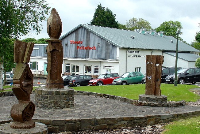
Theatr Felinfach

Theatr Felinfach is a small regional theatre located outside the village of Ystrad Aeron in Dyffryn Aeron, about 7 miles from the university town of Lampeter...

Llanfihangel Ystrad

Llanfihangel Ystrad (English "Vale of St Michael") is a constituent community in Ceredigion, Wales. It is named after the principal place of worship, St...

Ystrad Aeron

Ystrad Aeron is a small village west of Felinfach on the A482 between Lampeter and Aberaeron, Ceredigion, Wales. It is part of the constituent community...

Have you been to Allt Rhosgelli?

Leave your review of Allt Rhosgelli below (or comments, questions and feedback).