Allt Corgam

Wood, Forest in Cardiganshire

Wales

Allt Corgam

Y Bryn a'r Bragdy Beer is brewed on-site here and there is also a restaurant.
Y Bryn a'r Bragdy Credit: Eirian Evans

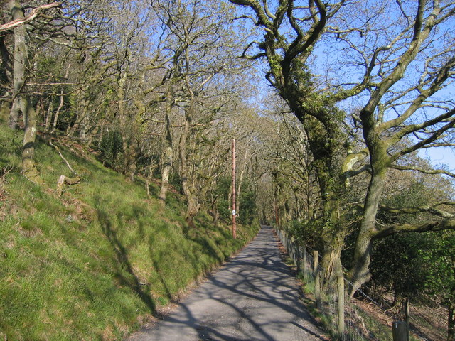
Allt Corgam is a picturesque wood located in the county of Cardiganshire, Wales. Covering an area of approximately 100 hectares, this forest is nestled in the heart of the Welsh countryside, offering visitors a tranquil and serene experience.

The wood is primarily composed of native tree species, including oak, birch, and beech, which create a lush and vibrant canopy. The forest floor is adorned with a variety of wildflowers, adding bursts of color to the landscape.

Allt Corgam is a haven for wildlife, providing a habitat for numerous species. Visitors may spot red deer, foxes, badgers, and a wide array of birds, including woodpeckers and owls. The area is also home to several rare and protected species, such as the dormouse and the silver-studded blue butterfly.

The wood offers a network of well-maintained trails, allowing visitors to explore its beauty on foot. These trails cater to all levels of fitness, ranging from gentle strolls to more challenging hikes. For those looking to spend a longer period in the forest, there are designated camping areas available.

In addition to its natural beauty, Allt Corgam holds historical significance. The wood is believed to have ancient origins and is thought to have been used by early communities for gathering resources and hunting.

Overall, Allt Corgam provides a captivating experience for nature enthusiasts, offering a glimpse into the beauty and biodiversity of the Welsh countryside.

If you have any feedback on the listing, please let us know in the comments section below.

Allt Corgam Images

Images are sourced within 2km of 52.149213/-4.4268085 or Grid Reference SN3452. Thanks to Geograph Open Source API. All images are credited.

Y Bryn a'r Bragdy Beer is brewed on-site here and there is also a restaurant.
Y Bryn a'r Bragdy
Beer is brewed on-site here and there is also a restaurant.
A487 nearing Pentregat
Direction Sign – Signpost on the B4321 in Pontgarreg Located in Pontgarreg, on the southeast of the junction on the B4321 near the bridge over Nant Hawen. Llangrannog community. 3 arms, 1 missing, and ogee finial. 

Milestone Society National ID: CRD_SN3354
Direction Sign – Signpost on the B4321 in Pontgarreg
Located in Pontgarreg, on the southeast of the junction on the B4321 near the bridge over Nant Hawen. Llangrannog community. 3 arms, 1 missing, and ogee finial. Milestone Society National ID: CRD_SN3354
Direction Sign – Signpost on the B4321 Located on the south of the junction on the B4321 and the minor road to Llwyndafydd. Llangrannog community. 3 arms and ogee finial. 

Milestone Society National ID: CRD_SN3254
Direction Sign – Signpost on the B4321
Located on the south of the junction on the B4321 and the minor road to Llwyndafydd. Llangrannog community. 3 arms and ogee finial. Milestone Society National ID: CRD_SN3254
Pontgarreg Primary School The 'Welsh Not' was used in this school during the eighteenth and nineteenth century in a bid to prevent pupils from speaking Welsh. The 'Welsh Not', which usually consisted of a small piece of wood or slate inscribed with the letters 'W.N', was hung around the neck of a child who was caught speaking Welsh. At the end of the school day, the child wearing the 'Welsh Not' would be punished by the schoolteacher.
Pontgarreg Primary School
The 'Welsh Not' was used in this school during the eighteenth and nineteenth century in a bid to prevent pupils from speaking Welsh. The 'Welsh Not', which usually consisted of a small piece of wood or slate inscribed with the letters 'W.N', was hung around the neck of a child who was caught speaking Welsh. At the end of the school day, the child wearing the 'Welsh Not' would be punished by the schoolteacher.
Milestone Old milestone on the A487 near Wervil Grange, Pentregat.
Milestone
Old milestone on the A487 near Wervil Grange, Pentregat.
New Inn New Inn Public House near Brynhoffnant
New Inn
New Inn Public House near Brynhoffnant
Tree in Lake View of Wervil Grange Farm with tree in lake
Tree in Lake
View of Wervil Grange Farm with tree in lake
Capel y Wig Capel y Wig Independent Chapel near the little Village of Pontgarreg.
Capel y Wig
Capel y Wig Independent Chapel near the little Village of Pontgarreg.
Small stream
Small stream
Farm house
Farm house
Lon uwchben Pontgarreg / Country Road above Pontgarreg Lon uwchben Pontgarreg gyda ty a gardd ar y de / Country Road above Pontgarreg with a house and garden on the right
Lon uwchben Pontgarreg / Country Road above Pontgarreg
Lon uwchben Pontgarreg gyda ty a gardd ar y de / Country Road above Pontgarreg with a house and garden on the right
Cae Porfa ger Llain Wen, Llangrannog / Grazing Field near Llain Wen, Llangrannog Cae Porfa gyda ffens trydan gyda golygfa draw i Langrannog / Grazing Field with an electric fence and distant view to Llangrannog
Cae Porfa ger Llain Wen, Llangrannog / Grazing Field near Llain Wen, Llangrannog
Cae Porfa gyda ffens trydan gyda golygfa draw i Langrannog / Grazing Field with an electric fence and distant view to Llangrannog
Coed Derw, Allt Hoffnant / Oak Woodland, Allt Hoffnant Coed Derw ar Allt Hoffnant ger Brynhoffnant / Oak Woodland at Allt Hoffnant near Brynhoffnant
Coed Derw, Allt Hoffnant / Oak Woodland, Allt Hoffnant
Coed Derw ar Allt Hoffnant ger Brynhoffnant / Oak Woodland at Allt Hoffnant near Brynhoffnant
B4321 ger Pentregat / The B4321 near Pentregat Ffordd B syn arwain i Langrannog / B road leading to Llangrannog
B4321 ger Pentregat / The B4321 near Pentregat
Ffordd B syn arwain i Langrannog / B road leading to Llangrannog
Lon Cae y Wig / Cae y Wig Lane Lon Cae y Wig ger Blaencelyn / Cae y Wig Lane near Blaencelyn
Lon Cae y Wig / Cae y Wig Lane
Lon Cae y Wig ger Blaencelyn / Cae y Wig Lane near Blaencelyn
Filling station and general stores, Brynhoffnant Serving the coast road and local people, the town/village of Brynhoffnant centred around the staples of shop/filling station, pub and chapel.
Filling station and general stores, Brynhoffnant
Serving the coast road and local people, the town/village of Brynhoffnant centred around the staples of shop/filling station, pub and chapel.
Boggy field by road junction Raindrops hanging from a metal gate, mists hanging in the trees: the next day the weather changed to glorious sun.
Boggy field by road junction
Raindrops hanging from a metal gate, mists hanging in the trees: the next day the weather changed to glorious sun.
Show me another place!

Allt Corgam is located at Grid Ref: SN3452 (Lat: 52.149213, Lng: -4.4268085)

Unitary Authority: Ceredigion

Police Authority: Dyfed Powys

What 3 Words

///outbound.shortens.degrading. Near Llanllwchaiarn, Ceredigion

Nearby Locations

Allt Corgam Allt Clun-coch

Related Wikis

Pentre-gat

Pentre-gat is a small village in the community of Llangrannog, Ceredigion, Wales, which is 69.6 miles (112 km) from Swansea and 381 miles (302.3 km) from...

Brynhoffnant

Brynhoffnant is a small village in the community of Penbryn, Ceredigion, Wales, which is 70.4 miles (113.3 km) from Cardiff and 189.1 miles (304.3 km)...

Pigeon's Ford

Pigeon's Ford is a hamlet in the community of Llangrannog, Ceredigion, Wales, which is 71.8 miles (115.5 km) from Cardiff and 189.9 miles (305.5 km) from...

Blaen Celyn

Blaen Celyn is a hamlet in the community of Llangrannog, Ceredigion, Wales, 2 miles (3.2 km) east of Llangrannog village. The local St. David's Church...

Penbontrhydyfoethau

Penbontrhydyfothau is a hamlet in the community of Llandysiliogogo, Ceredigion, Wales, which is 70.5 miles (113.4 km) from Cardiff and 187.9 miles (302...

Llangrannog

Llangrannog (sometimes spelt as Llangranog) is both a village and a community in Ceredigion, Wales, 6 miles (10 km) southwest of New Quay. It lies in...

Blaenbedw Fawr

Blaenbedw Fawr is a small village in the community of Llandysiliogogo, Ceredigion, Wales, which is 68.9 miles (110.8 km) from Cardiff and 187 miles (300...

River Hawen

The River Hawen (Welsh: Nant Hawen) is the main stream that flows through Llangrannog, Ceredigion, Wales into Cardigan Bay. It falls as a waterfall near...

Nearby Amenities

Located within 500m of 52.149213,-4.4268085
Place: farm
Lat/Long: 52.1481844/-4.429501
The data included in this document is from www.openstreetmap.org. The data is made available under ODbL.

Have you been to Allt Corgam?

Leave your review of Allt Corgam below (or comments, questions and feedback).