Allt y Bie

Wood, Forest in Cardiganshire

Wales

Allt y Bie

Pen Bryn-Bwa Trig Point Trig has been uprooted from the summit of Scotland Hill and relocated to the SSE gate corner. Up track from SE + cattle pasture gates.to find trig on way to TUMP summit. It doesn't get much better than bagging Scotland Hill in Wales.
Pen Bryn-Bwa Trig Point Credit: Rude Health

Allt y Bie is a picturesque wooded area located in Cardiganshire, Wales. Covering an expansive area, it is characterized by its dense forest and lush greenery. The name "Allt y Bie" translates to "the slope of the birch tree" in English, which is a fitting description for this enchanting woodland.

The forest is home to a diverse range of flora and fauna. Towering trees, including oak, beech, and birch, dominate the landscape, creating a serene and tranquil atmosphere. The forest floor is adorned with a variety of wildflowers, ferns, and mosses, adding to the natural beauty of the area. Wildlife such as deer, foxes, badgers, and numerous bird species can be spotted within the woods, making it a haven for nature lovers and wildlife enthusiasts.

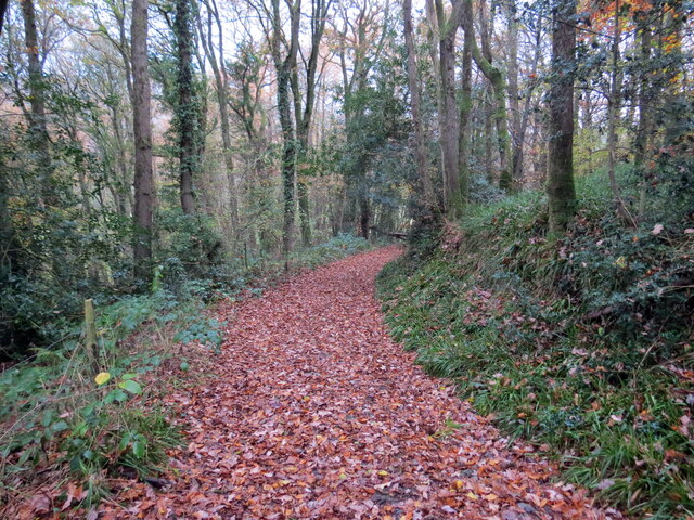
Allt y Bie offers several walking trails and paths, allowing visitors to explore its natural wonders. The trails wind through the forest, offering breathtaking views of the surrounding countryside and the nearby river. These paths are well-maintained, making it accessible for hikers of all levels of experience.

In addition to its natural beauty, Allt y Bie also holds historical significance. The area has archaeological remains dating back to the Bronze Age, including ancient burial sites and stone circles. This adds an element of intrigue and mystery to the woodland, attracting history buffs and those interested in the region's past.

Overall, Allt y Bie is a captivating woodland in Cardiganshire, Wales, offering a peaceful retreat for nature lovers, hikers, and history enthusiasts alike.

If you have any feedback on the listing, please let us know in the comments section below.
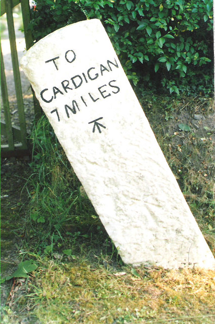
Allt y Bie Images

Images are sourced within 2km of 52.065764/-4.5360294 or Grid Reference SN2643. Thanks to Geograph Open Source API. All images are credited.

Pen Bryn-Bwa Trig Point Trig has been uprooted from the summit of Scotland Hill and relocated to the SSE gate corner. Up track from SE + cattle pasture gates.to find trig on way to TUMP summit. It doesn't get much better than bagging Scotland Hill in Wales.
Pen Bryn-Bwa Trig Point
Trig has been uprooted from the summit of Scotland Hill and relocated to the SSE gate corner. Up track from SE + cattle pasture gates.to find trig on way to TUMP summit. It doesn't get much better than bagging Scotland Hill in Wales.
The uprooted and moved Pen Bryn-Bwa Triangulation Pillar This pillar used to stand on the Tumuli at SN 2487 4537 but now stands abandoned in a nearby gateway.
Looking westward.
The uprooted and moved Pen Bryn-Bwa Triangulation Pillar
This pillar used to stand on the Tumuli at SN 2487 4537 but now stands abandoned in a nearby gateway. Looking westward.
War memorial,  Neuadd Cross Memorial on B4570 (foreground) at crossroads; The 'one way' sign detracts from the setting and seems superfluous for a short stretch of road.
War memorial, Neuadd Cross
Memorial on B4570 (foreground) at crossroads; The 'one way' sign detracts from the setting and seems superfluous for a short stretch of road.
Road to Beulah Minor road (direction sign obscured) from Neuadd Cross.
Road to Beulah
Minor road (direction sign obscured) from Neuadd Cross.
Old Milestone by the B4570, south east of Capel Tygwydd Cardigan tombstone by the B4570, in parish of Beulah (Ceredigion District), by "Milestone", South East of Capel Tygwydd, in front of domestic hedge.

Inscription reads:-
TO
CARDIGAN
7 MILES
Carved bench mark below inscription.

Grade II listed by Cadw. Reference Number: 16822
<span class="nowrap"><a title="https://cadwpublic-api.azurewebsites.net/reports/listedbuilding/FullReport?lang=&id=16822" rel="nofollow ugc noopener" href="https://cadwpublic-api.azurewebsites.net/reports/listedbuilding/FullReport?lang=&id=16822">Link</a><img style="margin-left:2px;" alt="External link" title="External link - shift click to open in new window" src="https://s1.geograph.org.uk/img/external.png" width="10" height="10"/></span>

Surveyed

Milestone Society National ID: CRD_CALA07.
Old Milestone by the B4570, south east of Capel Tygwydd
Cardigan tombstone by the B4570, in parish of Beulah (Ceredigion District), by "Milestone", South East of Capel Tygwydd, in front of domestic hedge. Inscription reads:- TO CARDIGAN 7 MILES Carved bench mark below inscription. Grade II listed by Cadw. Reference Number: 16822 LinkExternal link Surveyed Milestone Society National ID: CRD_CALA07.
Old Milestone by the B4570, Neuadd Cross, Beulah parish Cardigan tombstone by the B4570, in parish of Beulah (Ceredigion District), West of Neuadd Cross, opposite Ffynnoncripil, on verge under bracken.

Inscription reads:-
TO
CARDIGAN
5 MILES
{arrow->}
Carved bench mark on centre face.

Grade II listed by Cadw.
Reference Number: 17966 <span class="nowrap"><a title="https://cadwpublic-api.azurewebsites.net/reports/listedbuilding/FullReport?lang=&id=17966" rel="nofollow ugc noopener" href="https://cadwpublic-api.azurewebsites.net/reports/listedbuilding/FullReport?lang=&id=17966">Link</a><img style="margin-left:2px;" alt="External link" title="External link - shift click to open in new window" src="https://s1.geograph.org.uk/img/external.png" width="10" height="10"/></span>

Surveyed

Milestone Society National ID: CRD_CALA05
Old Milestone by the B4570, Neuadd Cross, Beulah parish
Cardigan tombstone by the B4570, in parish of Beulah (Ceredigion District), West of Neuadd Cross, opposite Ffynnoncripil, on verge under bracken. Inscription reads:- TO CARDIGAN 5 MILES {arrow->} Carved bench mark on centre face. Grade II listed by Cadw. Reference Number: 17966 LinkExternal link Surveyed Milestone Society National ID: CRD_CALA05
Old Milestone by the B4570, Nantgwgan, Beulah parish Cardigan tombstone by the B4570, in parish of Beulah (Ceredigion District), Nantgwgan, South of Ponthirwaun, on verge.

Inscription reads:-
TO
CARDIGAN
6 MILES
Carved bench mark middle face.

Grade II listed by Cadw.
Reference Number: 17974 <span class="nowrap"><a title="https://cadwpublic-api.azurewebsites.net/reports/listedbuilding/FullReport?lang=&id=17974" rel="nofollow ugc noopener" href="https://cadwpublic-api.azurewebsites.net/reports/listedbuilding/FullReport?lang=&id=17974">Link</a><img style="margin-left:2px;" alt="External link" title="External link - shift click to open in new window" src="https://s1.geograph.org.uk/img/external.png" width="10" height="10"/></span>

Surveyed

Milestone Society National ID: CRD_CALA06
Old Milestone by the B4570, Nantgwgan, Beulah parish
Cardigan tombstone by the B4570, in parish of Beulah (Ceredigion District), Nantgwgan, South of Ponthirwaun, on verge. Inscription reads:- TO CARDIGAN 6 MILES Carved bench mark middle face. Grade II listed by Cadw. Reference Number: 17974 LinkExternal link Surveyed Milestone Society National ID: CRD_CALA06
Ordnance Survey Cut Mark This OS cut mark can be found on the water tap at the road junction. It marks a point 118.909m above mean sea level.
Ordnance Survey Cut Mark
This OS cut mark can be found on the water tap at the road junction. It marks a point 118.909m above mean sea level.
Ordnance Survey Cut Mark This hidden and damaged OS cut mark can be found on the gatepost east side of the road. It marks a point 101.517m above mean sea level.
Ordnance Survey Cut Mark
This hidden and damaged OS cut mark can be found on the gatepost east side of the road. It marks a point 101.517m above mean sea level.
Ordnance Survey Cut Mark This OS cut mark can be found on the gatepost NW side of the road. It marks a point 133.698m above mean sea level.
Ordnance Survey Cut Mark
This OS cut mark can be found on the gatepost NW side of the road. It marks a point 133.698m above mean sea level.
Ordnance Survey Cut Mark This OS cut mark can be found on Pant Glas Cottage. It marks a point 68.753m above mean sea level.
Ordnance Survey Cut Mark
This OS cut mark can be found on Pant Glas Cottage. It marks a point 68.753m above mean sea level.
Ordnance Survey 1GL Bolt This OS bolt can be found on the SW angle of the chapel. It marks a point 56.6178m above mean sea level.
Ordnance Survey 1GL Bolt
This OS bolt can be found on the SW angle of the chapel. It marks a point 56.6178m above mean sea level.
Trac yn Allt Goch / A track at Allt Goch Trac yn mynd i lawr y waered yn Allt Goch.

A track descending the hill at Allt Goch (trans. red wooded slope).
Trac yn Allt Goch / A track at Allt Goch
Trac yn mynd i lawr y waered yn Allt Goch. A track descending the hill at Allt Goch (trans. red wooded slope).
Llwybr Alltgudd / Allgudd path Dwy dderwen ar hawl tramwy cyhoeddus.

Two oaks on a public right of way.
Llwybr Alltgudd / Allgudd path
Dwy dderwen ar hawl tramwy cyhoeddus. Two oaks on a public right of way.
Llwybr ceffyl Coedycwm / Coedycwm bridleway Llwybr ceffyl yn gadael heol fach ger Ffarm Coedycwm.

A public footpath exiting a minor road near Coedycwm Farm (trans. valley wood).
Llwybr ceffyl Coedycwm / Coedycwm bridleway
Llwybr ceffyl yn gadael heol fach ger Ffarm Coedycwm. A public footpath exiting a minor road near Coedycwm Farm (trans. valley wood).
Llwybr Coedycwm / Coedycwm path Llwybr ceffyl yn dringo'r allt uwchben Ffarm Coedybryn.

A bridleway ascending the hill near Coedybryn Farm (trans. valley wood).
Llwybr Coedycwm / Coedycwm path
Llwybr ceffyl yn dringo'r allt uwchben Ffarm Coedybryn. A bridleway ascending the hill near Coedybryn Farm (trans. valley wood).
Llwybr ger Penwern Fach / A path near Penwern Fach Llwybr yn mynd i lawr y waered tuag at Cwm Hirwaun.

A public right of way descends towards Cwm Hirwaun (trans. long meadow / fen valley).
Llwybr ger Penwern Fach / A path near Penwern Fach
Llwybr yn mynd i lawr y waered tuag at Cwm Hirwaun. A public right of way descends towards Cwm Hirwaun (trans. long meadow / fen valley).
Pont y Cwm Pont y Cwm yn rhychwantu Afon Hirwaun. Ar adeg ysgrifennu hwn mae'r bont ar gau oherwydd difrod strwythurol. 

Pont y Cwm (trans. valley bridge) spanning Afon Hirwaun (trans. long meadow / fen river). At the time of writing the bridge is closed due to structural damage.
Pont y Cwm
Pont y Cwm yn rhychwantu Afon Hirwaun. Ar adeg ysgrifennu hwn mae'r bont ar gau oherwydd difrod strwythurol. Pont y Cwm (trans. valley bridge) spanning Afon Hirwaun (trans. long meadow / fen river). At the time of writing the bridge is closed due to structural damage.
Show me another place!

Allt y Bie is located at Grid Ref: SN2643 (Lat: 52.065764, Lng: -4.5360294)

Unitary Authority: Ceredigion

Police Authority: Dyfed Powys

What 3 Words

///announced.repair.squares. Near Newcastle Emlyn, Ceredigion

Related Wikis

Blaen-pant

Blaen-pant is a small village in the community of Beulah, Ceredigion, Wales, which is 71.5 miles (115 km) from Cardiff and 192.8 miles (310.3 km) from...

Capel Tygwydd

Capel Tygwydd is a hamlet in the community of Beulah, Ceredigion, Wales, which is 70.3 miles (113.1 km) from Cardiff and 191.7 miles (308.5 km) from London...

Ponthirwaun

Ponthirwaun is a hamlet in the community of Beulah, Ceredigion, Wales, which is 71.3 miles (114.8 km) from Cardiff and 192.5 miles (309.7 km) from London...

Rhyd, Ceredigion

Rhyd, Ceredigion is a hamlet in the community of Beulah, Ceredigion, Wales, which is 71.1 miles (114.4 km) from Cardiff and 192.9 miles (310.4 km) from...

Nearby Amenities

Located within 500m of 52.065764,-4.5360294
Place: farm
Lat/Long: 52.0695605/-4.5334609
Direction: 255
Generator Method: photovoltaic
Generator Output Electricity: yes
Generator Solar Modules: 15
Generator Source: solar
Generator Type: solar_photovoltaic_panel
Location: roof
Power: generator
Lat/Long: 52.0654644/-4.5307741
Direction: 176
Generator Method: photovoltaic
Generator Output Electricity: yes
Generator Solar Modules: 11
Generator Source: solar
Generator Type: solar_photovoltaic_panel
Location: roof
Power: generator
Lat/Long: 52.0653597/-4.5309672
The data included in this document is from www.openstreetmap.org. The data is made available under ODbL.

Have you been to Allt y Bie?

Leave your review of Allt y Bie below (or comments, questions and feedback).