Burgh

Settlement in Suffolk East Suffolk

England

Burgh

Grassland near Hasketon
Grassland near Hasketon Credit: JThomas

Burgh is a small village located in the county of Suffolk, England. It is situated approximately 3 miles southeast of the market town of Woodbridge and 9 miles northeast of the county town of Ipswich. With a population of around 500 residents, Burgh maintains its rural charm and tranquility.

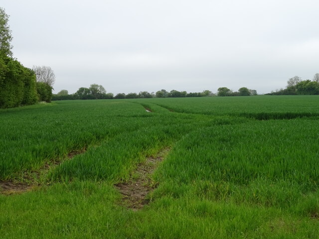
The village is characterized by its picturesque landscapes, featuring rolling hills, lush green fields, and traditional English cottages. It is surrounded by the beautiful countryside, making it an ideal destination for nature enthusiasts and those seeking a peaceful retreat.

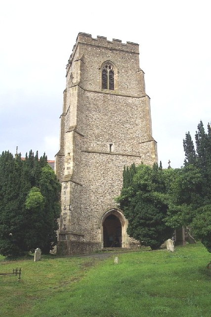
Burgh is known for its rich history, dating back to the medieval period. In the heart of the village lies St. Botolph's Church, a Grade I listed building that stands as a testament to its past. The church is renowned for its impressive architectural features, including a Norman tower and medieval stained glass windows.

A notable attraction in Burgh is the Burgh Grange Gardens, which are privately owned but open to the public. These stunning gardens offer a variety of flora and fauna, as well as tranquil paths and seating areas for visitors to enjoy.

Despite its small size, Burgh has a strong sense of community. The village hosts various events throughout the year, including summer fairs, harvest festivals, and Christmas markets. There is also a local pub, The Burgh, where residents and visitors can socialize and enjoy traditional pub fare.

Overall, Burgh is a charming village that offers a peaceful escape from the hustle and bustle of city life. Its beautiful surroundings, rich history, and close-knit community make it a hidden gem in the Suffolk countryside.

If you have any feedback on the listing, please let us know in the comments section below.

Burgh Images

Images are sourced within 2km of 52.116262/1.258411 or Grid Reference TM2351. Thanks to Geograph Open Source API. All images are credited.

Grassland near Hasketon
Riverside towards Hasketon A quiet lane.
Riverside towards Hasketon
A quiet lane.
Mill Lane towards Debach
Field margin (footpath) off Mill Lane
Crop field off Mill Lane
Mill Lane towards Debach
Footpath over crop field towards Hasketon Hall Off Mill Lane.
Footpath over crop field towards Hasketon Hall
Off Mill Lane.
Cereal crop towards Hall Farm
Hasketon Road towards Hasketon Hall
Footpath off Looms Lane
Christmas tree nursery, Lowood
Looms Lane towards Debach
Moat Barn Nursery School
Looms Lane towards Debach
Cereal crop off Looms Lane
Flooding in Grundisburgh The Ford at Grundisburgh at the height of the flooding caused by Storm Babet on 20th October 2023. The depth gauge in the ford shows a depth of 3.5 feet. The road past the Old Forge Stores to The Green was impassable for several hours.
Flooding in Grundisburgh
The Ford at Grundisburgh at the height of the flooding caused by Storm Babet on 20th October 2023. The depth gauge in the ford shows a depth of 3.5 feet. The road past the Old Forge Stores to The Green was impassable for several hours.
Flooding at The Green in Grundisburgh The Green at Grundisburgh was flooded as a result of Storm Babet. The roads through the village were impassable for several hours.
Flooding at The Green in Grundisburgh
The Green at Grundisburgh was flooded as a result of Storm Babet. The roads through the village were impassable for several hours.
Flooding in Grundisburgh Looking towards the village centre. The road was impassable for several hours.
Flooding in Grundisburgh
Looking towards the village centre. The road was impassable for several hours.
Show me another place!

Burgh is located at Grid Ref: TM2351 (Lat: 52.116262, Lng: 1.258411)

Administrative County: Suffolk

District: East Suffolk

Police Authority: Suffolk

What 3 Words

///marzipan.chin.activates. Near Grundisburgh, Suffolk

Nearby Locations

Burgh

Related Wikis

Burgh, Suffolk

Burgh () is a village and civil parish in the East Suffolk district of Suffolk, England, about 3.5 miles (6 km) north-west of Woodbridge.St Botolph's church...

Burgh Windmill

Burgh Mill is a Grade II listed tower mill at Burgh, Suffolk, England which has been converted to residential accommodation. == History == Burgh Mill was...

Clopton, Suffolk

Clopton is a village and civil parish in Suffolk. It is located between Ipswich and Debenham two kilometres north of Grundisburgh on the River Lark. The...

Grundisburgh

Grundisburgh () is a village of 1,584 residents situated in the English county of Suffolk. It is in the East Suffolk district, six 6 miles (10 km) north...

Nearby Amenities

Located within 500m of 52.116262,1.258411
Burgh
Place: village
Wikidata: Q3242373
Wikipedia: en:Burgh
Lat/Long: 52.1166641/1.2584744
Power: pole
Lat/Long: 52.1197862/1.2620679
Power: pole
Lat/Long: 52.1199805/1.260649
Power: pole
Lat/Long: 52.1199558/1.2591174
Power: pole
Lat/Long: 52.1199608/1.2570494
Power: pole
Lat/Long: 52.1199493/1.2554455
Public Bookcase
Booth: K6
Disused Amenity: telephone
Man Made: telephone_box
Public Bookcase Type: phone_box
Lat/Long: 52.1164811/1.2585193
Board Type: notice
Information: board
Tourism: information
Lat/Long: 52.116461/1.2584744
BURG MM
Artwork Subject: Mill Stone
Artwork Type: stone
Material: stone
Start Date: 2000
Tourism: artwork
Lat/Long: 52.11647/1.2584154
Bench
Backrest: yes
Material: wood
Lat/Long: 52.1164593/1.258357
Post Box
Collection Times: Mo-Fr 15:30; Sa 09:15
Post Box Mounting: wooden_post
Post Box Type: lamp
Ref: IP13 6273
Royal Cypher: GVIR
Royal Cypher Wikidata: Q33102169
Lat/Long: 52.1162131/1.258231
Post Box
Collection Times: Mo-Fr 09:00; Sa 07:00
Post Box Mounting: pier
Post Box Type: lamp
Ref: IP13 6331D
Royal Cypher: EIIR
Royal Cypher Wikidata: Q33102113
Lat/Long: 52.1137746/1.2542291
The data included in this document is from www.openstreetmap.org. The data is made available under ODbL.

Have you been to Burgh?

Leave your review of Burgh below (or comments, questions and feedback).