Allt Blaencwmmau

Wood, Forest in Carmarthenshire

Wales

Allt Blaencwmmau

Part of the Landsker Borderlands Trail just outside Llanboidy The Landsker Borderlands Trail heads southwestwards out of the village, passing between high hedgerows and verdant banks. It appears to have occasional vehicular use, is also used by the occasional horse rider and of course walkers.
Part of the Landsker Borderlands Trail just outside Llanboidy Credit: Jeremy Bolwell

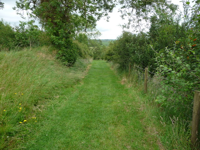
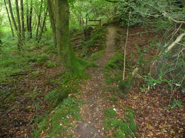
Allt Blaencwmmau is a picturesque woodland situated in the county of Carmarthenshire, Wales. Covering an area of approximately 50 acres, it is a stunning example of a natural forest ecosystem. The woodland is characterized by a diverse range of native tree species, including oak, beech, ash, and birch, which create a dense canopy providing shade and shelter for a variety of wildlife.

The forest is crisscrossed by a network of footpaths and trails, making it popular among walkers, hikers, and nature enthusiasts. These paths offer visitors the opportunity to explore the woodland and discover its hidden treasures, such as cascading waterfalls, vibrant wildflower meadows, and ancient ruins.

Allt Blaencwmmau is not only a haven for flora and fauna but also a cherished site of historical importance. The remnants of an Iron Age hillfort can be found within the woodland, providing insight into the area's rich past. Archaeological excavations have uncovered artifacts and evidence of human activity dating back thousands of years.

The natural beauty and cultural significance of Allt Blaencwmmau make it a popular destination for both locals and tourists alike. Visitors can immerse themselves in the tranquility of the forest, listen to the soothing sounds of nature, and enjoy breathtaking views of the surrounding countryside.

Conservation efforts are in place to protect and preserve the woodland, ensuring future generations can continue to appreciate its beauty. Allt Blaencwmmau truly is a hidden gem, offering a unique and enriching experience for all who venture into its depths.

If you have any feedback on the listing, please let us know in the comments section below.

Allt Blaencwmmau Images

Images are sourced within 2km of 51.872982/-4.6161838 or Grid Reference SN1922. Thanks to Geograph Open Source API. All images are credited.

Part of the Landsker Borderlands Trail just outside Llanboidy The Landsker Borderlands Trail heads southwestwards out of the village, passing between high hedgerows and verdant banks. It appears to have occasional vehicular use, is also used by the occasional horse rider and of course walkers.
Part of the Landsker Borderlands Trail just outside Llanboidy
The Landsker Borderlands Trail heads southwestwards out of the village, passing between high hedgerows and verdant banks. It appears to have occasional vehicular use, is also used by the occasional horse rider and of course walkers.
Part of the Landsker Borderlands Trail near Llanboidy The path leads through thistle patches parallel with the field edge.
Part of the Landsker Borderlands Trail near Llanboidy
The path leads through thistle patches parallel with the field edge.
Part of the Landsker Borderlands Trail near Llanboidy The path here is well maintained via mowing.
Part of the Landsker Borderlands Trail near Llanboidy
The path here is well maintained via mowing.
Stone circle beside the Landsker Borderlands Trail, near Llanboidy This modern stone circle sits in a field adjacent to the footpath. Various tree species have been planted out here too, such as Rowans and other saplings. Interesting.
Stone circle beside the Landsker Borderlands Trail, near Llanboidy
This modern stone circle sits in a field adjacent to the footpath. Various tree species have been planted out here too, such as Rowans and other saplings. Interesting.
Part of the Landsker Borderlands Trail The waymarkers have long faded into blank discs but the stiles and surface are well maintained.
Part of the Landsker Borderlands Trail
The waymarkers have long faded into blank discs but the stiles and surface are well maintained.
Dairy herd awaiting milking at Ffoswinau These ladies are impatiently awaiting some attention.
Dairy herd awaiting milking at Ffoswinau
These ladies are impatiently awaiting some attention.
Gates in the Carmarthenshire countryside A series of gates operate here at a corner of a lane and field access tracks.
Gates in the Carmarthenshire countryside
A series of gates operate here at a corner of a lane and field access tracks.
Field access track off the lane The open gate and mud shows that this gateway gets pretty frequent use, of late at least.
Field access track off the lane
The open gate and mud shows that this gateway gets pretty frequent use, of late at least.
Part of the Landsker Borderlands Trail in woodland The footpath here follows a small earthen embankment through woodland.
Part of the Landsker Borderlands Trail in woodland
The footpath here follows a small earthen embankment through woodland.
Wooden bridge across a stream valley The wooden bridge is narrow and the handrail is set high, so feels a little awkward to cross. It serves a vital purpose though, as in wet weather the valley is obviously a quagmire.
Wooden bridge across a stream valley
The wooden bridge is narrow and the handrail is set high, so feels a little awkward to cross. It serves a vital purpose though, as in wet weather the valley is obviously a quagmire.
Castell Mawr motte and bailey at Llanboidy Little seems known about this site. It is not known or recorded as 'Llanboidy Castle' and as it has never been excavated little is known about its date or founding, or founder, who could be either Norman English or Welsh. It is most likely a Norman motte and bailey 12th century foundation but fell out of use soon after and was never re-built in stone. It stands on private land.
Castell Mawr motte and bailey at Llanboidy
Little seems known about this site. It is not known or recorded as 'Llanboidy Castle' and as it has never been excavated little is known about its date or founding, or founder, who could be either Norman English or Welsh. It is most likely a Norman motte and bailey 12th century foundation but fell out of use soon after and was never re-built in stone. It stands on private land.
The old Maesgwynne Arms in Llanboidy What a shame that a magnificent building like this is boarded up and non-operational. It looks like it has great potential as a hotel, gastro pub etc.
The old Maesgwynne Arms in Llanboidy
What a shame that a magnificent building like this is boarded up and non-operational. It looks like it has great potential as a hotel, gastro pub etc.
The old Maesgwynne Arms in Llanboidy This was the village's biggest public house, but seems to have lost its status altogether. I'm no expert publican, property developer, hotelier or entrepreneur but I can see potential here for someone with the vision (and dosh) to transform this place into an historic destination dining hotel.
The old Maesgwynne Arms in Llanboidy
This was the village's biggest public house, but seems to have lost its status altogether. I'm no expert publican, property developer, hotelier or entrepreneur but I can see potential here for someone with the vision (and dosh) to transform this place into an historic destination dining hotel.
Llanboidy village hall What a magnificent village hall. There isn't one thing about it that I dislike. And plenty to really like.
Llanboidy village hall
What a magnificent village hall. There isn't one thing about it that I dislike. And plenty to really like.
Monkey-puzzle tree in the garden Not everyone can enjoy owning a mature specimen like this.
Monkey-puzzle tree in the garden
Not everyone can enjoy owning a mature specimen like this.
Sign post Sign post opposite Can-erw Cottage Llanboidy
Sign post
Sign post opposite Can-erw Cottage Llanboidy
Horse drawn agricultural implements Decorative feature to this farm building at Plas-newydd Llanboidy, Horse drawn implements (hoe and plough) and iron implement wheel.
Horse drawn agricultural implements
Decorative feature to this farm building at Plas-newydd Llanboidy, Horse drawn implements (hoe and plough) and iron implement wheel.
Information and history of Llanboidy In entrance to Llanboidy's civic amenities site, Maesgwynne Arms behind on other side of road.
Information and history of Llanboidy
In entrance to Llanboidy's civic amenities site, Maesgwynne Arms behind on other side of road.
Show me another place!

Allt Blaencwmmau is located at Grid Ref: SN1922 (Lat: 51.872982, Lng: -4.6161838)

Unitary Authority: Carmarthenshire

Police Authority: Dyfed Powys

What 3 Words

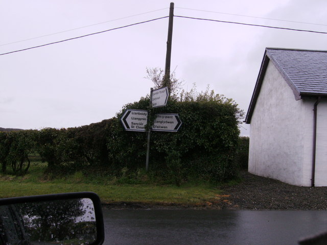
///approvals.ghosts.model. Near Llanboidy, Carmarthenshire

Related Wikis

Llanboidy

Llanboidy is a village and community in Carmarthenshire, West Wales. The community includes the village of Llanglydwen. == Location == According to the...

Login Halt railway station

Login Halt railway station served the hamlet of Login, Carmarthenshire, Wales, from 1875 to 1962 on the Whitland and Cardigan Railway. == History == The...

Henllanfallteg

Henllanfallteg (Welsh: Henllan Fallteg) is a community in the west of Carmarthenshire, Wales. It comprises the villages of Cwmfelin Boeth, Henllan Amgoed...

Henllan Amgoed

Henllan Amgoed is a small village near Whitland, Carmarthenshire and forms part of the community of Henllanfallteg. The village is home to a chapel and...

Login, Carmarthenshire

Login is a hamlet in Carmarthenshire, Wales, in the Taf valley and sits on both sides of the meandering River Taf. A stone bridge crosses the river approximately...

Cwmfelin Mynach

Cwmfelin Mynach is a village in Carmarthenshire, Wales. It has a population of only 64 residents. Cwmfelin Mynach means Valley (cwm) of the Monks' (Mynach...

Whitland Abbey

Whitland Abbey (Welsh: Abaty Hendy-gwyn ar Daf or simply Y Tŷ Gwyn ar Daf; Latin: Albalanda) was a country house and Cistercian abbey in the parish of...

Llanglydwen railway station

Llanglydwen railway station served the village of Llanglydwen, Carmarthenshire, Wales, from 1875 to 1963 on the Whitland and Cardigan Railway. == History... ==

Nearby Amenities

Located within 500m of 51.872982,-4.6161838
Give Way
Direction: backward
Lat/Long: 51.876639/-4.6195955
Give Way
Direction: forward
Lat/Long: 51.8702535/-4.6208246
The data included in this document is from www.openstreetmap.org. The data is made available under ODbL.

Have you been to Allt Blaencwmmau?

Leave your review of Allt Blaencwmmau below (or comments, questions and feedback).