Carnedd y Filiast

Hill, Mountain in Caernarfonshire

Wales

Carnedd y Filiast

Wild Goats on Elidir Fawr
Wild Goats on Elidir Fawr Credit: Chris Andrews

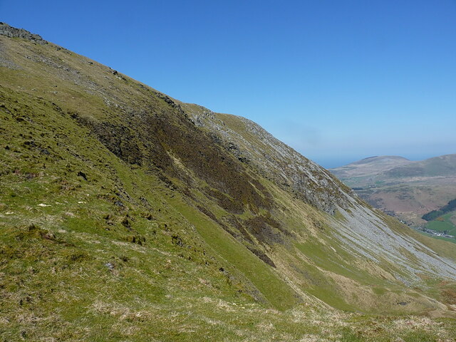
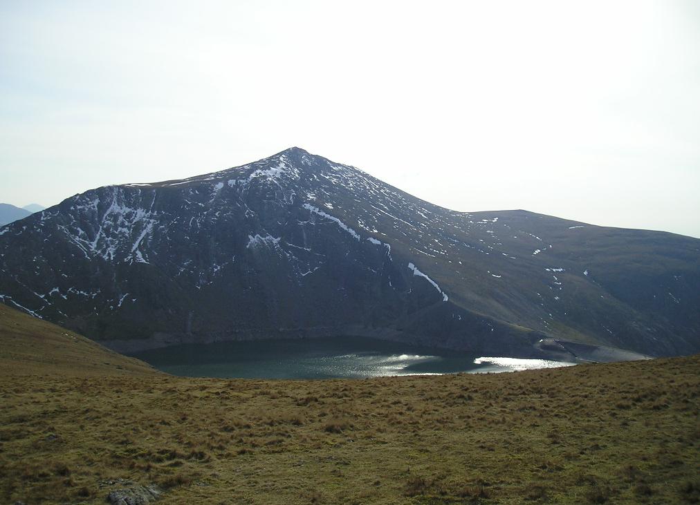
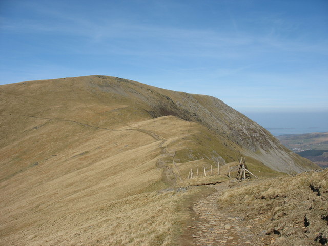
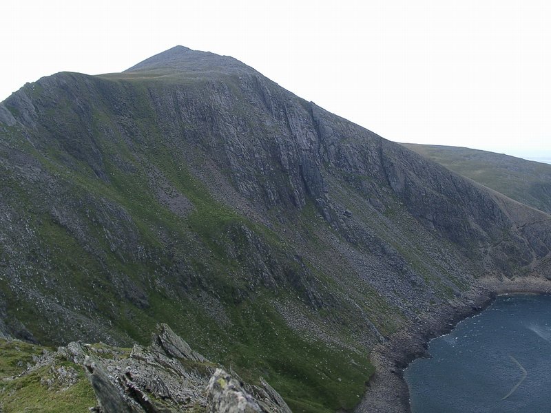
Carnedd y Filiast, located in Caernarfonshire, Wales, is a prominent hill/mountain within the Snowdonia National Park. With an elevation of 821 meters (2,694 feet), it is a popular destination for hikers and outdoor enthusiasts seeking breathtaking views and challenging trails.

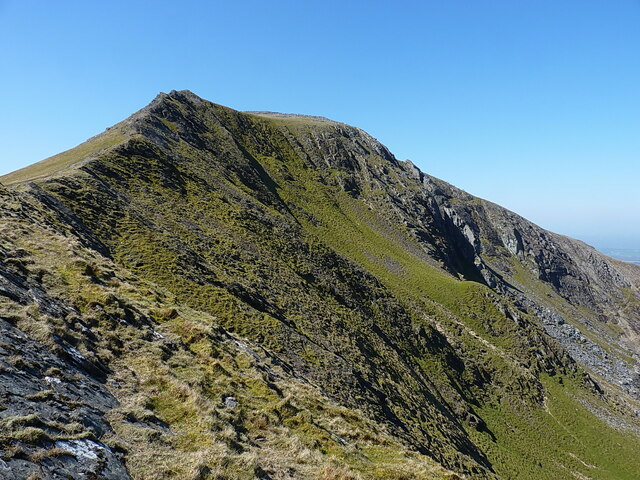
The name "Carnedd y Filiast" translates to "Cairn of the Greyhound Bitch," reflecting the hill's distinct shape resembling a crouching dog. Its unique silhouette can be seen from various vantage points, adding to its allure.

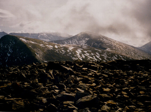
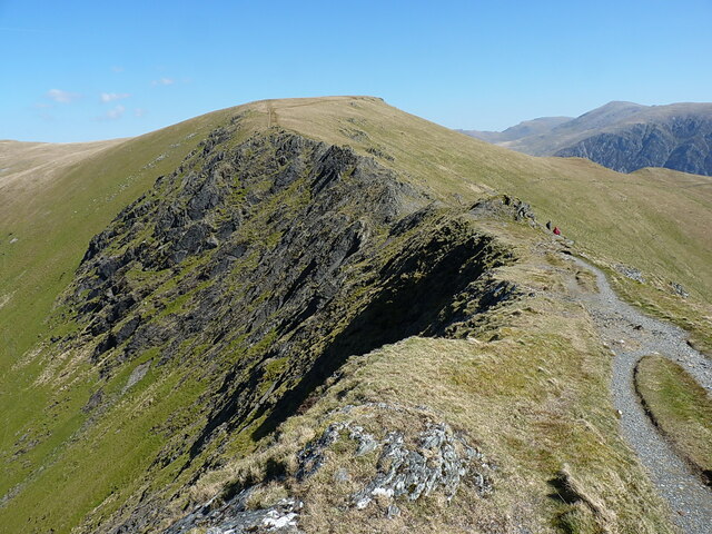
The hill is formed mainly of igneous rocks, including volcanic ash and lava flows, which were shaped by glaciation during the last Ice Age. This geological history has resulted in an intriguing landscape with steep slopes and rocky outcrops, providing a thrilling terrain for adventurous climbers.

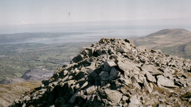
Hiking to the summit of Carnedd y Filiast rewards visitors with panoramic views of the surrounding mountains, valleys, and lakes. On a clear day, one can see as far as the Irish Sea and the Isle of Man. The route to the top is marked by well-defined footpaths, but caution is advised as the weather conditions can change rapidly, especially in higher elevations.

Aside from its natural beauty, Carnedd y Filiast also holds historical significance. Ruins of ancient settlements and burial mounds can be found in the vicinity, showcasing the area's rich cultural heritage.

Overall, Carnedd y Filiast offers a captivating blend of natural wonders and historical intrigue, making it a must-visit destination for those seeking an exhilarating outdoor experience in Caernarfonshire.

If you have any feedback on the listing, please let us know in the comments section below.

Carnedd y Filiast Images

Images are sourced within 2km of 53.143521/-4.0646807 or Grid Reference SH6262. Thanks to Geograph Open Source API. All images are credited.

Wild Goats on Elidir Fawr
Foel Goch and Y Garn from the block field on Moel Perfedd
Tai-newyddion (new houses) on the map Now this is the Snowdonia Mountain Hostel, in a wonderful setting.
Tai-newyddion (new houses) on the map
Now this is the Snowdonia Mountain Hostel, in a wonderful setting.
The old road up the Nant Ffrancon
Morainic deposits on the shores of the Marchlyn Bach Reservoir A snowy Carnedd y Filiast forms the background.
Morainic deposits on the shores of the Marchlyn Bach Reservoir
A snowy Carnedd y Filiast forms the background.
Blockfield on the summit of Elidir Fawr The waste tips of the Penrhyn Quarry  can be seen below on the left.
Blockfield on the summit of Elidir Fawr
The waste tips of the Penrhyn Quarry can be seen below on the left.
Cairn on the summit of Carnedd y Filiast On the other side of the Marchlyn Valley is Elidir Fach with the disused Marchlyn Quarry on its north-eastern flank.
Cairn on the summit of Carnedd y Filiast
On the other side of the Marchlyn Valley is Elidir Fach with the disused Marchlyn Quarry on its north-eastern flank.
Men and dogs at the Elidir Fawr summit wind shelter
Dew ponds in the col between Carnedd y Filiast and Y Fronllwyd The image was created on the summit ridge of Carnedd y Filiast.
Dew ponds in the col between Carnedd y Filiast and Y Fronllwyd
The image was created on the summit ridge of Carnedd y Filiast.
Nant Ffrancon The Nant Ffrancon is a steep-sided glacial valley which runs between Bethesda in the north to Llyn Ogwen in the south, a distance of about 3½ miles. The A5 road runs along the east side of the valley, the original road, Lord Penrhyn's Highway, runs along the west side of the valley. The Afon/River Ogwen meanders along the floor of the valley.
Nant Ffrancon
The Nant Ffrancon is a steep-sided glacial valley which runs between Bethesda in the north to Llyn Ogwen in the south, a distance of about 3½ miles. The A5 road runs along the east side of the valley, the original road, Lord Penrhyn's Highway, runs along the west side of the valley. The Afon/River Ogwen meanders along the floor of the valley.
Path contouring below Foel Goch Rather than ascend and redescend the summit of Foel Goch, this path allows walkers to make an easy traverse of the hillside below that hill, when they're walking between Elidir Fawr and Y Garn.
Path contouring below Foel Goch
Rather than ascend and redescend the summit of Foel Goch, this path allows walkers to make an easy traverse of the hillside below that hill, when they're walking between Elidir Fawr and Y Garn.
View directly down Cwm Dudodyn Something of a hanging valley above Nant Peris, Cwm Dudodyn has a stream which flows into Llyn Peris more or less here <a href="https://www.geograph.org.uk/photo/4169217">SH6058 : Looking over Llyn Peris</a>. On the far side of the valley are the hills of Yr Wyddfa, with Moel Cynghorion and the Nantlle Ridge beyond that again.
View directly down Cwm Dudodyn
Something of a hanging valley above Nant Peris, Cwm Dudodyn has a stream which flows into Llyn Peris more or less here SH6058 : Looking over Llyn Peris. On the far side of the valley are the hills of Yr Wyddfa, with Moel Cynghorion and the Nantlle Ridge beyond that again.
Elidir Fawr's north face Across the rocky outcrops of Craig Cwrwgl from Bwlch y Marchlyn. The sun is just picking out the steep rib of the Pillar of Elidir, the home of a series of respectable but little-frequented climbs on the north face of the mountain.
Elidir Fawr's north face
Across the rocky outcrops of Craig Cwrwgl from Bwlch y Marchlyn. The sun is just picking out the steep rib of the Pillar of Elidir, the home of a series of respectable but little-frequented climbs on the north face of the mountain.
View down towards Bwlch y Marchlyn A similar view to that in <a href="https://www.geograph.org.uk/photo/4277690">SH6161 : Bwlch y Marchlyn</a> but in rather more benign conditions (to be fair, it was colder than it looks in my photo, even though it was April).
View down towards Bwlch y Marchlyn
A similar view to that in SH6161 : Bwlch y Marchlyn but in rather more benign conditions (to be fair, it was colder than it looks in my photo, even though it was April).
Wind shelter and a standing stone on Mynydd Perfedd The wind shelter looks to have been recently rebuilt, it's certainly tidier than it was in 2007 <a href="https://www.geograph.org.uk/photo/543166">SH6261 : Cairn shelter on summit of Mynydd Perfedd</a>  and <a href="https://www.geograph.org.uk/photo/580782">SH6261 : Summit Cairn of Mynydd Perfedd</a>, and is a perfect place to sit and boil up a packet of soup. The slightly tilted standing stone in the foreground isn't marked on the OS maps, nor recorded by any of the archeological surveys that I can find, so I'm assuming it's not of antiquity.
Wind shelter and a standing stone on Mynydd Perfedd
The wind shelter looks to have been recently rebuilt, it's certainly tidier than it was in 2007 SH6261 : Cairn shelter on summit of Mynydd Perfedd and SH6261 : Summit Cairn of Mynydd Perfedd, and is a perfect place to sit and boil up a packet of soup. The slightly tilted standing stone in the foreground isn't marked on the OS maps, nor recorded by any of the archeological surveys that I can find, so I'm assuming it's not of antiquity.
On the plateau edge, north of Mynydd Perfedd Between Mynydd Perfedd and Carnedd y Filiast there's an extensive grassy plateau area with steep-walled cwms bitten out of the eastern side by glaciers. This is the view along the boundary line between those two habitats, with ever-steepening ground on the right.
On the plateau edge, north of Mynydd Perfedd
Between Mynydd Perfedd and Carnedd y Filiast there's an extensive grassy plateau area with steep-walled cwms bitten out of the eastern side by glaciers. This is the view along the boundary line between those two habitats, with ever-steepening ground on the right.
The steep eastern face of Mynydd Perfedd The 'headwall' of Cwm Perfedd is mainly comprised of steep(ish) scree and boulders with a partial covering of heather and grass.
The steep eastern face of Mynydd Perfedd
The 'headwall' of Cwm Perfedd is mainly comprised of steep(ish) scree and boulders with a partial covering of heather and grass.
Grassy spur between two cwms This grassy hillside separates Cwm Perfedd (off to the left) from Cwm Bual (down to the right) and initially at least provides a very reasonable descent route into the Nant Ffrancon from Bwlch Brecan, It becomes quite a bit steeper and more entertaining further down.
Grassy spur between two cwms
This grassy hillside separates Cwm Perfedd (off to the left) from Cwm Bual (down to the right) and initially at least provides a very reasonable descent route into the Nant Ffrancon from Bwlch Brecan, It becomes quite a bit steeper and more entertaining further down.
Show me another place!

Carnedd y Filiast is located at Grid Ref: SH6262 (Lat: 53.143521, Lng: -4.0646807)

Unitary Authority: Gwynedd

Police Authority: North Wales

What 3 Words

///refuses.diverting.thudding. Near Bethesda, Gwynedd

Related Wikis

Carnedd y Filiast (Glyderau)

Carnedd y Filiast is a mountain in Snowdonia, Wales, forming part of the Glyderau. It, along with its top Y Fronllwyd (721 m), forms the most northerly...

Marchlyn Mawr

Marchlyn Mawr reservoir is a high level lake in Snowdonia behind Elidir Fawr mountain. It is used as the high level water source for Dinorwig power station...

Mynydd Perfedd

Mynydd Perfedd is a mountain in Snowdonia, Wales, forming part of the Glyderau. The summit has a shelter cairn, offering good views of Foel-goch's north...

Elidir Fawr

Elidir Fawr is a mountain in Snowdonia, north Wales, the northernmost peak in the Glyderau. Its name means 'Big Elidir', named after a legendary warrior...

Nearby Amenities

Located within 500m of 53.143521,-4.0646807
Carnedd Y Filiast
Ele: 821
Natural: peak
Source: GPS
Wikidata: Q15056727
Wikipedia: en:Carnedd y Filiast (Glyderau)
Lat/Long: 53.1439141/-4.0640912
Barrier: stile
Ele: 803.781982
Source: GPS
Lat/Long: 53.1423542/-4.0625891
Natural: spring
Lat/Long: 53.142742/-4.0685356
The data included in this document is from www.openstreetmap.org. The data is made available under ODbL.

Have you been to Carnedd y Filiast?

Leave your review of Carnedd y Filiast below (or comments, questions and feedback).