Castell Rhaglan

Heritage Site in Monmouthshire

Wales

Castell Rhaglan

Raglan Castle
Raglan Castle Credit: Nigel Thompson

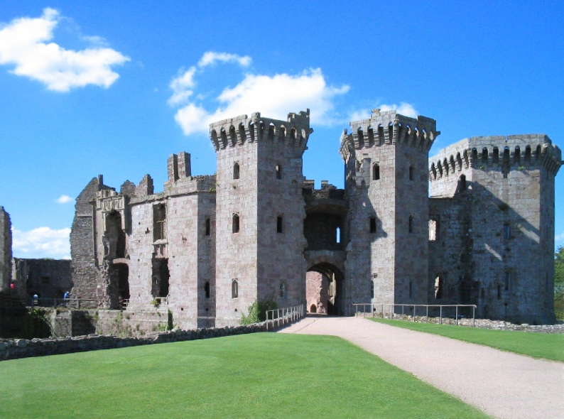
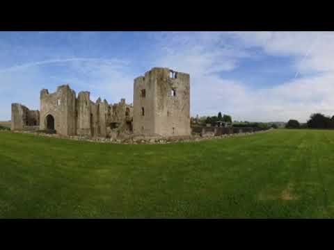
Castell Rhaglan, located in Monmouthshire, Wales, is a historic site of great cultural and architectural significance. Also known as Raglan Castle, it is a medieval fortress that stands as a testament to the rich history of the area.

The castle was constructed in the 15th century by Sir William ap Thomas, a prominent Welsh nobleman. It was built in a unique combination of Gothic and Tudor architectural styles, showcasing the evolving trends of the time. The main features of the castle include a large gatehouse, a Great Tower, and a stunning octagonal keep.

Castell Rhaglan played a significant role during the English Civil War of the 17th century. It was one of the last strongholds to hold out against Parliamentary forces, enduring a long siege before finally surrendering. The scars of this conflict can still be seen in the damaged walls and ruined sections of the castle.

Today, Castell Rhaglan is a popular heritage site, attracting visitors from around the world. Its well-preserved structure and picturesque surroundings make it an ideal destination for history enthusiasts and photographers alike. The site offers guided tours, allowing visitors to explore the castle's impressive interior, including the lavish banqueting hall and the underground wine cellar.

Additionally, the castle hosts various events and reenactments, providing visitors with a glimpse into the past. The beautifully landscaped gardens surrounding the castle offer a serene setting for leisurely walks and picnics.

Castell Rhaglan stands as a remarkable example of medieval architecture and remains a cherished symbol of Welsh history and heritage.

If you have any feedback on the listing, please let us know in the comments section below.

Castell Rhaglan Images

Images are sourced within 2km of 51.7702/-2.8498 or Grid Reference SO4108. Thanks to Geograph Open Source API. All images are credited.

Raglan Castle
Raglan Castle
Junction of Fayre Oaks/Derwen Deg with Chepstow Road, Raglan
"The Beaufort" at the junction of Chepstow Road and High Street, Raglan
Little Castle Farm electricity substation, Raglan The green cabinet is a Western Power Distribution electricity substation. Its identifier is S/S 53-7252.
Little Castle Farm electricity substation, Raglan
The green cabinet is a Western Power Distribution electricity substation. Its identifier is S/S 53-7252.
Gates across the entrance to Little Castle Business Park, Raglan Set back from the north side of Pen-y-parc Road.
Gates across the entrance to Little Castle Business Park, Raglan
Set back from the north side of Pen-y-parc Road.
Little Castle Business Park information boards, Raglan The boards show the names of the occupiers of the business park units. Viewed on January 2nd 2022.
Little Castle Business Park information boards, Raglan
The boards show the names of the occupiers of the business park units. Viewed on January 2nd 2022.
Brewery Shop direction sign, Raglan The sign at the entrance to Little Castle Business Park is on the right here. <a title="https://www.geograph.org.uk/photo/7060354" href="https://www.geograph.org.uk/photo/7060354">Link</a>
Brewery Shop direction sign, Raglan
The sign at the entrance to Little Castle Business Park is on the right here. Link
Bend in Pen-y-parc Road, Raglan Looking south from the edge of Little Castle Business Park in January 2022.
Bend in Pen-y-parc Road, Raglan
Looking south from the edge of Little Castle Business Park in January 2022.
NW along Pen-y-parc Road, Raglan Pen-y-parc Farm is out of shot ahead.
NW along Pen-y-parc Road, Raglan
Pen-y-parc Farm is out of shot ahead.
Businesses at the edge of Raglan Viewed across Pen-y-parc Road in January 2022.
Names in view include Oilfast and MDP Landrovers.
Businesses at the edge of Raglan
Viewed across Pen-y-parc Road in January 2022. Names in view include Oilfast and MDP Landrovers.
St Cadoc's Church, Raglan A late-medieval parish church rebuilt in the C15th and C16th, partly through the patronage of the Herberts of Raglan Castle who added the Beaufort chapel. The nave, porch, chancel and tower are broadly contemporary c. 1500 but heavily restored by T. H. Wyatt 1868, who installed new windows, roofs, and rebuilt the top stage of the tower. It is listed Grade II*
St Cadoc's Church, Raglan
A late-medieval parish church rebuilt in the C15th and C16th, partly through the patronage of the Herberts of Raglan Castle who added the Beaufort chapel. The nave, porch, chancel and tower are broadly contemporary c. 1500 but heavily restored by T. H. Wyatt 1868, who installed new windows, roofs, and rebuilt the top stage of the tower. It is listed Grade II*
Yew in St Cadoc's Churchyard, Raglan
Churchyard Information board, St Cadoc The churchyard is divided into 6 areas and the graves are numbered. Pictures around the map refer to specific graves, and each grave has its specific QR code which can be used to access further information.
Churchyard Information board, St Cadoc
The churchyard is divided into 6 areas and the graves are numbered. Pictures around the map refer to specific graves, and each grave has its specific QR code which can be used to access further information.
C15 tower, Church of St Cadoc
War memorial and seating area At the junction of Chepstow Road and High Street
War memorial and seating area
At the junction of Chepstow Road and High Street
Ship Inn, Raglan According to the signboard, this is a C16 free house. Situated on the High Street.
Ship Inn, Raglan
According to the signboard, this is a C16 free house. Situated on the High Street.
Raglan Castle View to the castle from the A40
Raglan Castle
View to the castle from the A40
Twyn-yr-argoed Pasture east of Raglan.
Twyn-yr-argoed
Pasture east of Raglan.
Show me another place!

Castell Rhaglan is located at Grid Ref: SO4108 (Lat: 51.7702, Lng: -2.8498)

Unitary Authority: Monmouthshire

Police Authority: Gwent

Also known as: Raglan Castle

What 3 Words

///layered.invoices.remarked. Near Raglan, Monmouthshire

Related Wikis

Raglan Castle

Raglan Castle (Welsh: Castell Rhaglan) is a late medieval castle located just north of the village of Raglan in the county of Monmouthshire in south east...

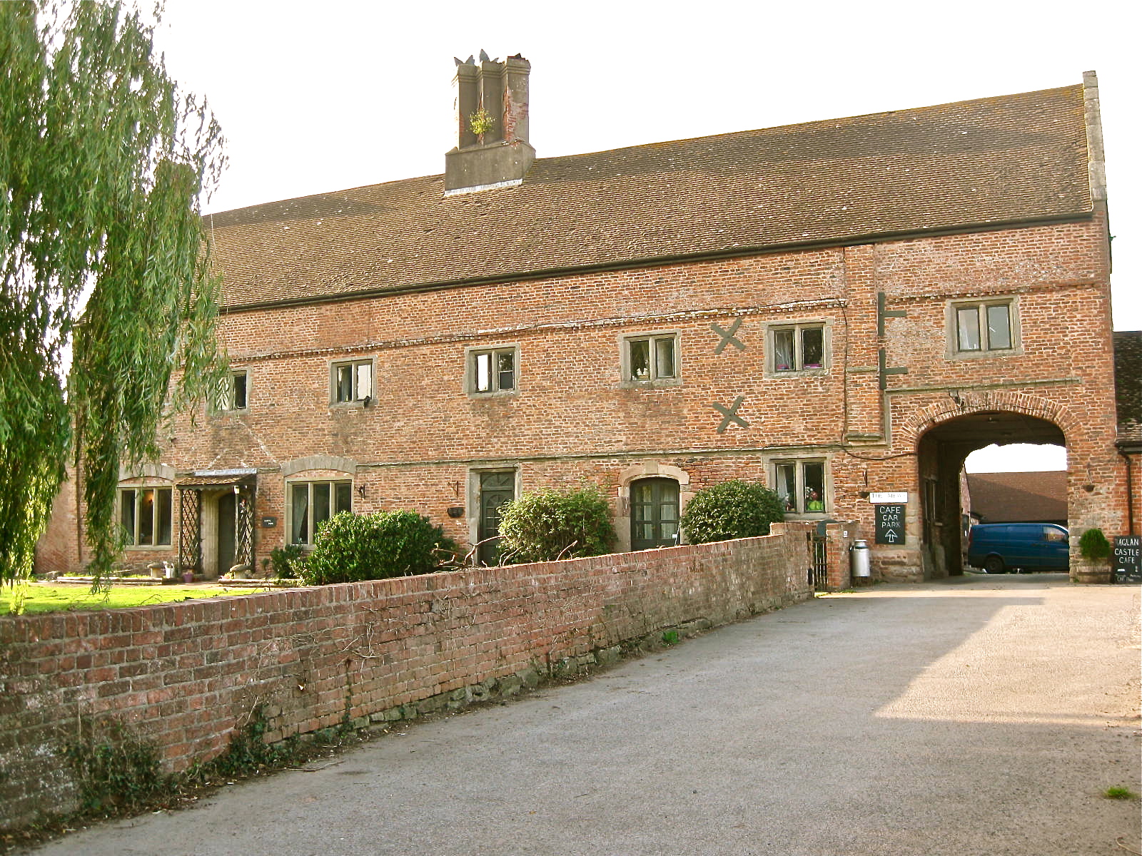
Castle Farmhouse, Raglan

Castle Farm, Raglan, in the county of Monmouth, is prominently sited 100 yards (91 m) east of Raglan Castle. The farm is approached from its own drive...

Raglan, Monmouthshire

Raglan (; (Welsh: Rhaglan) is a village and community in Monmouthshire, south east Wales, United Kingdom. It is located some 9 miles south-west of Monmouth...

St Cadoc's Church, Raglan

St Cadoc's Church, Raglan, Monmouthshire, south east Wales, is the parish church of the village of Raglan. The church is situated at a cross-roads in the...

Raglan railway station

Raglan railway station was a station on the Coleford, Monmouth, Usk and Pontypool Railway. It was not opened when the line was originally built, but constructed...

Raglan Footpath railway station

Raglan Footpath was a station on the former Coleford, Monmouth, Usk and Pontypool Railway. It was opened in October 1857 with the rest of the line and...

Elms Bridge Halt railway station

Elms Bridge Halt was a request stop on the former Coleford, Monmouth, Usk and Pontypool Railway. It was opened on 27 November 1933 to serve the villages...
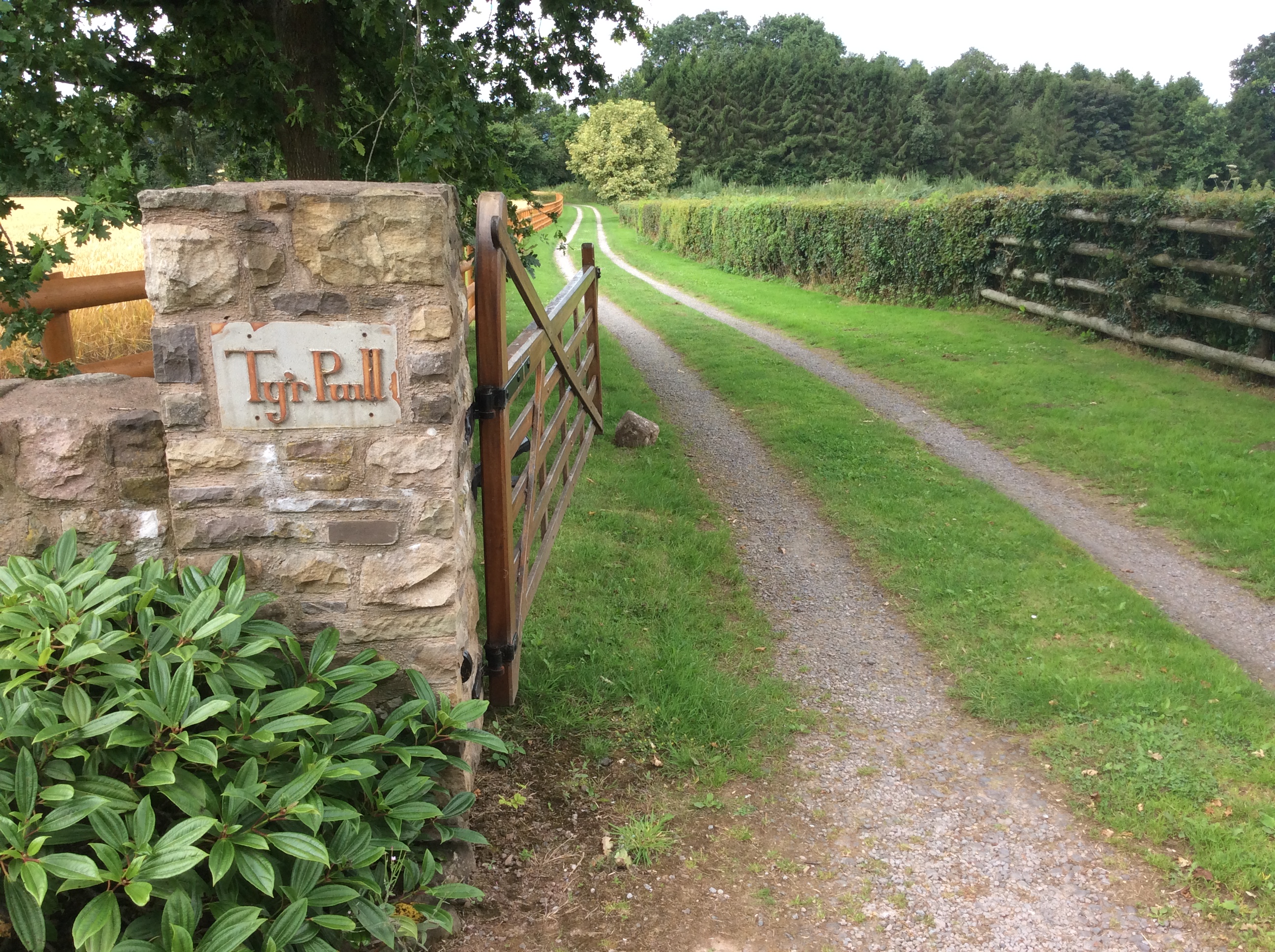
Pwll, Tregare

Pwll, Tregare, Monmouthshire is a medieval cruck-house dating from the late 14th century, with additions in the 17th century. An "extremely rare survival...

Related Videos

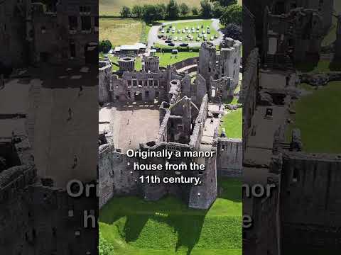
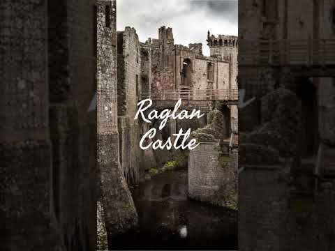
Raglan Castle #shorts

Raglan Castle: https://youtu.be/rWmPtW1PfEM To donate and support our channel: https://www.buymeacoffee.com/TheyhadadaA ...

Raglan Castle - Wales

Welcome to my series of Castle Shorts! In each video I tell you a small nugget of information about each Castle. In this Short I tell ...

Nearby Amenities

Located within 500m of 51.7702,-2.8498
Parking
Access: customers
Parking: surface
Lat/Long: 51.7696795/-2.8489651
Cafe
Raglan Castle Cafe
Lat/Long: 51.7708994/-2.8483599
Barrier: stile
Lat/Long: 51.7668222/-2.8533153
Barrier: stile
Dog: no
Lat/Long: 51.771472/-2.8463283
Barrier: stile
Lat/Long: 51.7738847/-2.8465643
Direction: 215
Generator Method: photovoltaic
Generator Output Electricity: yes
Generator Solar Modules: 10
Generator Source: solar
Generator Type: solar_photovoltaic_panel
Location: roof
Power: generator
Lat/Long: 51.7664671/-2.8527237
Direction: 195
Generator Method: photovoltaic
Generator Output Electricity: yes
Generator Solar Modules: 14
Generator Source: solar
Generator Type: solar_photovoltaic_panel
Location: roof
Power: generator
Lat/Long: 51.7670929/-2.8466392
Direction: 170
Generator Method: photovoltaic
Generator Output Electricity: yes
Generator Solar Modules: 18
Generator Source: solar
Generator Type: solar_photovoltaic_panel
Location: roof
Power: generator
Lat/Long: 51.7671444/-2.8483102
Direction: 145
Generator Method: photovoltaic
Generator Output Electricity: yes
Generator Solar Modules: 16
Generator Source: solar
Generator Type: solar_photovoltaic_panel
Location: roof
Power: generator
Lat/Long: 51.7675357/-2.8445182
Direction: 195
Generator Method: photovoltaic
Generator Output Electricity: yes
Generator Solar Modules: 4
Generator Source: solar
Generator Type: solar_photovoltaic_panel
Location: roof
Power: generator
Lat/Long: 51.7667684/-2.8465332
Direction: 195
Generator Method: photovoltaic
Generator Output Electricity: yes
Generator Solar Modules: 15
Generator Source: solar
Generator Type: solar_photovoltaic_panel
Location: roof
Power: generator
Lat/Long: 51.7668423/-2.8466177
The data included in this document is from www.openstreetmap.org. The data is made available under ODbL.

Have you been to Castell Rhaglan?

Leave your review of Castell Rhaglan below (or comments, questions and feedback).