Westwell

Civil Parish in Oxfordshire West Oxfordshire

England

Westwell

Holwell Church
Holwell Church Credit: AJD

Westwell is a civil parish located in the Cherwell district of Oxfordshire, England. It is a small village situated about 17 miles northwest of Oxford. The village is surrounded by picturesque countryside, with rolling hills and lush green fields, making it an ideal location for those seeking a peaceful and idyllic setting.

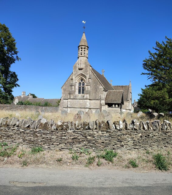
Westwell has a rich history dating back to the medieval period, evident from the charming architecture of the village. The centerpiece of the village is the All Saints' Church, a Grade II listed building that dates back to the 12th century. The church boasts a beautiful Norman doorway and an impressive medieval wall painting.

Despite its small size, Westwell has a strong sense of community. The village has a local pub, The Blue Boar, which serves as a popular meeting point for residents and visitors alike. The pub offers a warm and friendly atmosphere, along with a range of traditional pub food and a selection of locally brewed ales.

The surrounding countryside offers ample opportunities for outdoor activities. There are several footpaths and trails that crisscross the village, providing stunning views of the Oxfordshire countryside. Additionally, the nearby River Swere offers fishing opportunities for those interested in angling.

Overall, Westwell is a charming and historic village that offers a peaceful and scenic retreat from the hustle and bustle of city life. It is a place where residents and visitors can enjoy the beauty of the countryside and experience a strong sense of community.

If you have any feedback on the listing, please let us know in the comments section below.

Westwell Images

Images are sourced within 2km of 51.787829/-1.687493 or Grid Reference SP2109. Thanks to Geograph Open Source API. All images are credited.

Holwell Church
Holwell Church
Westwell War Memorial
Westwell war memorial With the exception of a very few villages known as 'Thankful Villages' almost every village and town in Britain has a war memorial.  This one in the village of Westwell is a little different to most in that it looks more like an old market cross.  The other thing which is unusual about the war memorial is that it includes a Gothic brass numeral "1" salvaged from the clock of the Cloth Hall, Ypres.  <a href="https://www.geograph.org.uk/photo/7610631">SP2209 : Detail of Westwell war memorial</a> The memorial became a Grade II listed, see: <span class="nowrap"><a title="https://historicengland.org.uk/listing/the-list/list-entry/1065940?section=official-list-entry" rel="nofollow ugc noopener" href="https://historicengland.org.uk/listing/the-list/list-entry/1065940?section=official-list-entry">Link</a><img style="margin-left:2px;" alt="External link" title="External link - shift click to open in new window" src="https://s1.geograph.org.uk/img/external.png" width="10" height="10"/></span>
Westwell war memorial
With the exception of a very few villages known as 'Thankful Villages' almost every village and town in Britain has a war memorial. This one in the village of Westwell is a little different to most in that it looks more like an old market cross. The other thing which is unusual about the war memorial is that it includes a Gothic brass numeral "1" salvaged from the clock of the Cloth Hall, Ypres. SP2209 : Detail of Westwell war memorial The memorial became a Grade II listed, see: LinkExternal link
Detail of Westwell war memorial This is symbolic of the destruction war brings, it was the number 1 on the clock of the Cloth Hall in Ypres which was destroyed during the First World War.  It is inscribed "To the brave who gave their lives for England in the Great War. Erected by Stretta Aimee Holland in memory of her brothers Lt. Harold S. Price Royal Fusiliers Lt. Edward John Price RN".
Detail of Westwell war memorial
This is symbolic of the destruction war brings, it was the number 1 on the clock of the Cloth Hall in Ypres which was destroyed during the First World War. It is inscribed "To the brave who gave their lives for England in the Great War. Erected by Stretta Aimee Holland in memory of her brothers Lt. Harold S. Price Royal Fusiliers Lt. Edward John Price RN".
Church of St Mary the Virgin, Holwell
Seven Shires Way by Tom Jollys Seven Shires Way passing by Tom Jollys
Seven Shires Way by Tom Jollys
Seven Shires Way passing by Tom Jollys
Seven Shires Way heading to Holwell Downs Farm Seven Shires Way heading down the restricted byway to Holwell Downs Farm
Seven Shires Way heading to Holwell Downs Farm
Seven Shires Way heading down the restricted byway to Holwell Downs Farm
Seven Shires Way heading to Holwell From Holwell Downs Farm the Seven Shires Way heading to Holwell
Seven Shires Way heading to Holwell
From Holwell Downs Farm the Seven Shires Way heading to Holwell
Church of St Mary the Virgin Holwell Church of St Mary the Virgin Holwell with village war memorial in front
Church of St Mary the Virgin Holwell
Church of St Mary the Virgin Holwell with village war memorial in front
Seven Shires Way Seven Shires Way from Holwell heading towards Westwell
Seven Shires Way
Seven Shires Way from Holwell heading towards Westwell
St Mary the Virgin, Holwell
The village cross, Holwell
The pond at Westwell
Looking towards the pond and the manor house, Westwell The oldest part of the manor house was built in 1545.
Looking towards the pond and the manor house, Westwell
The oldest part of the manor house was built in 1545.
Detail of War Memorial, Westwell See <a title="https://www.geograph.org.uk/photo/636699" href="https://www.geograph.org.uk/photo/636699">Link</a> for a wider view. The metal object is purportedly a numeral taken from the clock on the cloth hall at Ypres. It has been inscribed. It has been attached to a medieval cross (partly broken) in the village of Westwell. In 21st century eyes, this seems like two acts of vandalism although at the time it was done I'm sure it was perfectly acceptable.
Detail of War Memorial, Westwell
See Link for a wider view. The metal object is purportedly a numeral taken from the clock on the cloth hall at Ypres. It has been inscribed. It has been attached to a medieval cross (partly broken) in the village of Westwell. In 21st century eyes, this seems like two acts of vandalism although at the time it was done I'm sure it was perfectly acceptable.
Holwell Downs Farm Looking north-east from the road to the Barringtons.
Holwell Downs Farm
Looking north-east from the road to the Barringtons.
The road to the Barringtons, heading north West of Holwell Downs Farm, and just north of the crossroads.
The road to the Barringtons, heading north
West of Holwell Downs Farm, and just north of the crossroads.
Square brick structure in a field No idea what it is! On the west side of the road to the Barringtons, south-west of Tom Jollys.
Square brick structure in a field
No idea what it is! On the west side of the road to the Barringtons, south-west of Tom Jollys.
Show me another place!

Westwell is located at Grid Ref: SP2109 (Lat: 51.787829, Lng: -1.687493)

Administrative County: Oxfordshire

District: West Oxfordshire

Police Authority: Thames Valley

What 3 Words

///winner.chapters.rebounder. Near Burford, Oxfordshire

Nearby Locations

Westwell Copse Westwell

Related Wikis

Westwell War Memorial

The Westwell War Memorial is a memorial to the Price brothers erected in the hamlet of Westwell, Oxfordshire after the First World War. The limestone...

Westwell, Oxfordshire

Westwell is a small village and civil parish about 2 miles (3 km) southwest of the market town of Burford in Oxfordshire. It is the westernmost village...

Holwell, Oxfordshire

Holwell is a village and civil parish about 2 miles (3 km) south of Burford in West Oxfordshire. The 2001 Census recorded the parish's population as 17...

Cotswold Wildlife Park

The Cotswold Wildlife Park & Gardens exhibits over 260 different species of animals. The park is set in 160 acres (0.65 km2) of landscaped parkland and...

Church of St Peter, Little Barrington

The Anglican Church of St Peter at Little Barrington in the civil parish of Barrington in the Cotswold District of Gloucestershire, England was built in...

Upton, West Oxfordshire

Upton is a hamlet on the River Windrush about 1 mile (1.6 km) west of Burford in Oxfordshire, England. Until 1954 Upton was part of the civil parish of...

Signet, Oxfordshire

Signet is a hamlet on the A361 road just over 1 mile (1.6 km) south of Burford in Oxfordshire, England. Until 1954 Signet was part of the civil parish...

Windrush, Gloucestershire

Windrush is a village and civil parish in Gloucestershire, England, approximately five miles southeast of Northleach. It lies in the Cotswolds on the River...

Nearby Amenities

Located within 500m of 51.787829,-1.687493
The data included in this document is from www.openstreetmap.org. The data is made available under ODbL.

Have you been to Westwell?

Leave your review of Westwell below (or comments, questions and feedback).