Weston

Civil Parish in Lincolnshire South Holland

England

Weston

Harrox House, Moulton Dates from the late eighteenth century <span class="nowrap"><a title="https://historicengland.org.uk/listing/the-list/list-entry/1064506" rel="nofollow ugc noopener" href="https://historicengland.org.uk/listing/the-list/list-entry/1064506">Link</a><img style="margin-left:2px;" alt="External link" title="External link - shift click to open in new window" src="https://s1.geograph.org.uk/img/external.png" width="10" height="10"/></span>
Harrox House, Moulton Credit: Jonathan Thacker

The requested URL returned error: 429 Too Many Requests

If you have any feedback on the listing, please let us know in the comments section below.
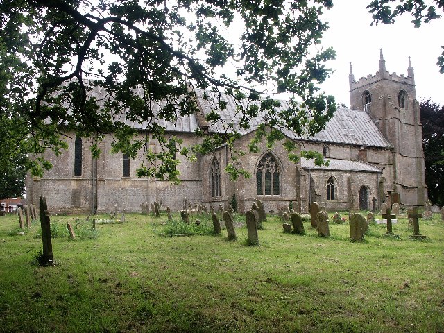
Weston Images

Images are sourced within 2km of 52.803212/-0.091119 or Grid Reference TF2824. Thanks to Geograph Open Source API. All images are credited.

Harrox House, Moulton Dates from the late eighteenth century <span class="nowrap"><a title="https://historicengland.org.uk/listing/the-list/list-entry/1064506" rel="nofollow ugc noopener" href="https://historicengland.org.uk/listing/the-list/list-entry/1064506">Link</a><img style="margin-left:2px;" alt="External link" title="External link - shift click to open in new window" src="https://s1.geograph.org.uk/img/external.png" width="10" height="10"/></span>
Harrox House, Moulton
Dates from the late eighteenth century LinkExternal link
Moulton Fish & Chips What a pity it was closed. I could have done with a nice hot lunch.  
It might have been sunny, but the NW wind was cold and quite strong.
Moulton Fish & Chips
What a pity it was closed. I could have done with a nice hot lunch. It might have been sunny, but the NW wind was cold and quite strong.
All Saint's Church, Moulton, Lincolnshire “The Queen of the Fens” dates back to about 1180, the spire is about 158 feet high.
All Saint's Church, Moulton, Lincolnshire
“The Queen of the Fens” dates back to about 1180, the spire is about 158 feet high.
Moulton Church and Windmill: aerial 2023 (1) Windmill is the tallest tower mill in the United Kingdom.

Dated 1822 it is Grade I listed and 9 stories high. 

New sails were fitted on 21 November 2011 to complete the restoration of the mill. The community restoration took 14 years to complete at a cost of nearly £2m.

See: <span class="nowrap"><a title="https://en.wikipedia.org/wiki/Moulton_Windmill" rel="nofollow ugc noopener" href="https://en.wikipedia.org/wiki/Moulton_Windmill">Link</a><img style="margin-left:2px;" alt="External link" title="External link - shift click to open in new window" src="https://s1.geograph.org.uk/img/external.png" width="10" height="10"/></span>
Moulton Church and Windmill: aerial 2023 (1)
Windmill is the tallest tower mill in the United Kingdom. Dated 1822 it is Grade I listed and 9 stories high. New sails were fitted on 21 November 2011 to complete the restoration of the mill. The community restoration took 14 years to complete at a cost of nearly £2m. See: LinkExternal link
Moulton Church and Windmill: aerial 2023 (3) Windmill is the tallest tower mill in the United Kingdom.

Dated 1822 it is Grade I listed and 9 stories high. 

New sails were fitted on 21 November 2011 to complete the restoration of the mill. The community restoration took 14 years to complete at a cost of nearly £2m.

See: <span class="nowrap"><a title="https://en.wikipedia.org/wiki/Moulton_Windmill" rel="nofollow ugc noopener" href="https://en.wikipedia.org/wiki/Moulton_Windmill">Link</a><img style="margin-left:2px;" alt="External link" title="External link - shift click to open in new window" src="https://s1.geograph.org.uk/img/external.png" width="10" height="10"/></span>
Moulton Church and Windmill: aerial 2023 (3)
Windmill is the tallest tower mill in the United Kingdom. Dated 1822 it is Grade I listed and 9 stories high. New sails were fitted on 21 November 2011 to complete the restoration of the mill. The community restoration took 14 years to complete at a cost of nearly £2m. See: LinkExternal link
Park House Park, Moulton: aerial 2023 (1) See: <span class="nowrap"><a title="https://www.heritagegateway.org.uk/Gateway/Results_Single.aspx?uid=MLI92280&resourceID=1006" rel="nofollow ugc noopener" href="https://www.heritagegateway.org.uk/Gateway/Results_Single.aspx?uid=MLI92280&resourceID=1006">Link</a><img style="margin-left:2px;" alt="External link" title="External link - shift click to open in new window" src="https://s1.geograph.org.uk/img/external.png" width="10" height="10"/></span>
Park House Park, Moulton: aerial 2023 (1)
See: LinkExternal link
Park House Park, Moulton: aerial 2023 (2)  See: <span class="nowrap"><a title="https://www.heritagegateway.org.uk/Gateway/Results_Single.aspx?uid=MLI92280&resourceID=1006" rel="nofollow ugc noopener" href="https://www.heritagegateway.org.uk/Gateway/Results_Single.aspx?uid=MLI92280&resourceID=1006">Link</a><img style="margin-left:2px;" alt="External link" title="External link - shift click to open in new window" src="https://s1.geograph.org.uk/img/external.png" width="10" height="10"/></span>
Park House Park, Moulton: aerial 2023 (2)
See: LinkExternal link
Moulton: 'Harrox House', site of Moulton Grammar School (1562-1939) Now a private residence.
Moulton: 'Harrox House', site of Moulton Grammar School (1562-1939)
Now a private residence.
Moulton: Village pump
Moulton: Little Village Salon, hairdressers
Moulton, All Saints Church: The nave
Moulton, All Saints Church: The font, installed during the 1868 restoration
Moulton, All Saints Church: The font, installed during the 1868 restoration (detail) 1
Moulton, All Saints Church: The font, installed during the 1868 restoration (detail) 2
Moulton, All Saints Church: The font, installed during the 1868 restoration (detail) 3
Moulton, All Saints Church: The Adam and Eve font 1719
Moulton, All Saints Church: The Adam and Eve font 1719 (detail) 1
Moulton, All Saints Church: The Adam and Eve font 1719 (detail) 2
Show me another place!

Weston is located at Grid Ref: TF2824 (Lat: 52.803212, Lng: -0.091119)

Administrative County: Lincolnshire

District: South Holland

Police Authority: Lincolnshire

What 3 Words

///mentioned.water.fruitcake. Near Whaplode, Lincolnshire

Nearby Locations

Weston

Related Wikis

Weston, Lincolnshire

Weston is a village and civil parish in the South Holland district of Lincolnshire, England. It is situated approximately 2 miles (3 km) north-east from...

Weston railway station (Lincolnshire)

Weston railway station was a station in Weston, Lincolnshire on the Midland and Great Northern Joint Railway, Built by the Norwich and Spalding Railway...

Moulton Windmill

Moulton Windmill in the Lincolnshire village of Moulton, between Spalding and Holbeach is a restored windmill claimed to be the tallest tower mill in the...

Moulton, Lincolnshire

Moulton is a village in the civil parish of The Moultons, in the South Holland district of Lincolnshire, England. It is situated on the A151 and B1537...

Nearby Amenities

Located within 500m of 52.803212,-0.091119
Mini Roundabout
Direction: clockwise
Lat/Long: 52.8027702/-0.098511
Weston
Is In: Lincolnshire, England, UK
Place: village
Wikidata: Q7989361
Lat/Long: 52.8056758/-0.0865961
Mini Roundabout
Direction: clockwise
Lat/Long: 52.8029408/-0.0976014
Bus Stop
Baytree Nurseries, adj
Bus: yes
Naptan AtcoCode: 270002700756
Naptan Bearing: NE
Naptan CommonName: Baytree Nurseries
Naptan Indicator: o/s
Naptan Landmark: Baytree Nurseries
Naptan Street: High Road
Naptan Verified: no
Public Transport: platform
Source: naptan_import
Wheelchair: yes
Lat/Long: 52.8033252/-0.0961017
Bus Stop
Baytree Nurseries, opp
Bus: yes
Naptan AtcoCode: 270002700757
Naptan Bearing: SW
Naptan CommonName: Baytree Nurseries
Naptan Indicator: opp
Naptan Landmark: Baytree Nurseries
Naptan Street: High Road
Naptan Verified: no
Public Transport: platform
Source: naptan_import
Wheelchair: yes
Lat/Long: 52.8034129/-0.0954006
Bus Stop
Wimberley Close, adj
Bus: yes
Naptan AtcoCode: 270002701089
Naptan Bearing: SW
Naptan CommonName: Wimberley Close
Naptan Indicator: adj
Naptan Landmark: Wimberley Close
Naptan Street: High Road
Naptan Verified: no
Public Transport: platform
Source: naptan_import
Lat/Long: 52.8057706/-0.088265
Bus Stop
Wimberley Close, opp
Bus: yes
Naptan AtcoCode: 270002701091
Naptan Bearing: NE
Naptan CommonName: Wimberley Close
Naptan Indicator: opp
Naptan Landmark: Wimberley Close
Naptan Street: High Road
Naptan Verified: no
Public Transport: platform
Source: naptan_import
Lat/Long: 52.8059576/-0.0881529
Post Box
Collection Times: Mo-Fr 16:30; Sa 12:05
Post Box Type: lamp
Ref: PE12 101
Lat/Long: 52.800011/-0.095621
Leisure: playground
Lat/Long: 52.8025522/-0.0852017
Baytree Nurseries
Addr City: Spalding
Addr Country: GB
Addr Postcode: PE12 6JU
Addr Street: High Road
Addr Suburb: Weston
Fhrs Authority: South Holland
Fhrs Id: 243127
Fhrs Local Authority Id: 4880
Shop: garden_centre
Lat/Long: 52.8045419/-0.0972837
Cafe
The Baytree Coffee Lounge
Addr City: Spalding
Addr Country: GB
Addr Housename: Baytree Nurseries Garden Centre
Addr Postcode: PE12 6JU
Addr Street: High Road
Addr Suburb: Weston
Fhrs Authority: South Holland
Fhrs Id: 590166
Fhrs Local Authority Id: 36347
Lat/Long: 52.8043862/-0.0970101
Generator Method: photovoltaic
Generator Output Electricity: yes
Generator Source: solar
Generator Type: solar_photovoltaic_panel
Location: roof
Power: generator
Lat/Long: 52.8051912/-0.0955804
Generator Method: photovoltaic
Generator Output Electricity: yes
Generator Source: solar
Generator Type: solar_photovoltaic_panel
Location: roof
Power: generator
Lat/Long: 52.8052171/-0.0953015
Generator Method: photovoltaic
Generator Output Electricity: yes
Generator Source: solar
Generator Type: solar_photovoltaic_panel
Location: roof
Power: generator
Lat/Long: 52.803187/-0.0950413
Generator Method: photovoltaic
Generator Output Electricity: yes
Generator Source: solar
Generator Type: solar_photovoltaic_panel
Location: roof
Power: generator
Lat/Long: 52.8032372/-0.0947288
Generator Method: photovoltaic
Generator Output Electricity: yes
Generator Source: solar
Generator Type: solar_photovoltaic_panel
Location: roof
Power: generator
Lat/Long: 52.804296/-0.0937096
Generator Method: photovoltaic
Generator Output Electricity: yes
Generator Source: solar
Generator Type: solar_photovoltaic_panel
Location: roof
Power: generator
Lat/Long: 52.804904/-0.0912715
Generator Method: photovoltaic
Generator Output Electricity: yes
Generator Source: solar
Generator Type: solar_photovoltaic_panel
Location: roof
Power: generator
Lat/Long: 52.8046948/-0.0886375
Generator Method: photovoltaic
Generator Output Electricity: yes
Generator Source: solar
Generator Type: solar_photovoltaic_panel
Location: roof
Power: generator
Lat/Long: 52.802787/-0.0918173
Generator Method: photovoltaic
Generator Output Electricity: yes
Generator Source: solar
Generator Type: solar_photovoltaic_panel
Location: roof
Power: generator
Lat/Long: 52.8016145/-0.0931866
Generator Method: photovoltaic
Generator Output Electricity: yes
Generator Source: solar
Generator Type: solar_photovoltaic_panel
Location: roof
Power: generator
Lat/Long: 52.8016428/-0.0932147
Generator Method: photovoltaic
Generator Output Electricity: yes
Generator Source: solar
Generator Type: solar_photovoltaic_panel
Location: roof
Power: generator
Lat/Long: 52.8039413/-0.0879428
Generator Method: photovoltaic
Generator Output Electricity: yes
Generator Source: solar
Generator Type: solar_photovoltaic_panel
Location: roof
Power: generator
Lat/Long: 52.8041456/-0.087393
Generator Method: photovoltaic
Generator Output Electricity: yes
Generator Source: solar
Generator Type: solar_photovoltaic_panel
Location: roof
Power: generator
Lat/Long: 52.8033835/-0.0874305
Generator Method: photovoltaic
Generator Output Electricity: yes
Generator Source: solar
Generator Type: solar_photovoltaic_panel
Location: roof
Power: generator
Lat/Long: 52.8036559/-0.0872696
Generator Method: photovoltaic
Generator Output Electricity: yes
Generator Source: solar
Generator Type: solar_photovoltaic_panel
Location: roof
Power: generator
Lat/Long: 52.8041261/-0.0870094
Noexit: yes
Lat/Long: 52.8060405/-0.0962514
The data included in this document is from www.openstreetmap.org. The data is made available under ODbL.

Have you been to Weston?

Leave your review of Weston below (or comments, questions and feedback).