West Parley

Civil Parish in Dorset East Dorset

England

West Parley

Northbourne: New Road One of the most important routes into Bournemouth, New Road is the A347 from Ferndown. It is not 'new' but it was when it was built (which I suppose is true of all roads!).

We see it here as it crosses Ensbury Bridge, over the River Stour, and therefore over the historic boundary into the Borough of Bournemouth, as it was until April 2019 when Bournemouth, Poole and Christchurch local authorities merged.

The sign is of a design that became prevalent in Bournemouth around 1990 and was in use for most of that decade, with blue border and, when mounted on the pavement, on blue legs. The addition here of the word Bournemouth and the borough coat of arms is of course because this is the entry point to the borough. The centre point of the river is the boundary, so the positioning of the sign is very exact!

This is photo no.248 of a series of 453 in my coronavirus lockdown walking project:
See <a title="https://www.geograph.org.uk/article/My-2020-Coronavirus-Lockdown-walking-project" href="https://www.geograph.org.uk/article/My-2020-Coronavirus-Lockdown-walking-project">Link</a> for the complete set of photos.
Northbourne: New Road Credit: Chris Downer

West Parley is a civil parish located in the county of Dorset, England. Situated approximately 3 miles north of the coastal town of Bournemouth, it is a small and picturesque village with a population of around 4,000 residents.

The village of West Parley is surrounded by beautiful countryside, including the nearby Parley Common, a Local Nature Reserve known for its heathland and woodland. The area offers scenic views and plenty of opportunities for outdoor activities, such as walking, cycling, and birdwatching.

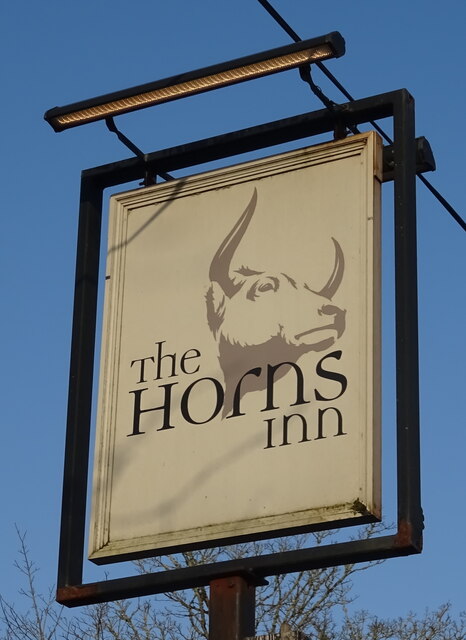
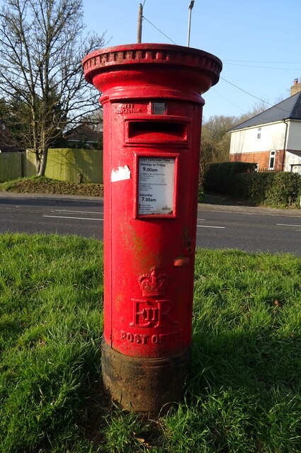
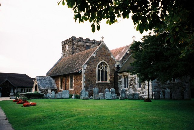
West Parley is known for its close-knit community and friendly atmosphere. The village has a range of amenities and services, including a primary school, a village hall, a post office, a convenience store, and several pubs and restaurants. There is also a church, St. Mark's, which dates back to the 12th century and is an important historical landmark in the area.

The village is well-connected to other nearby towns and cities. Bournemouth Airport is just a short drive away, providing convenient access to domestic and international destinations. The A31 road runs through West Parley, connecting it to major transport routes and making it easily accessible by car.

Overall, West Parley offers a peaceful and idyllic setting for its residents, with a range of amenities and natural beauty to enjoy. Its close proximity to Bournemouth and other nearby towns makes it an attractive place to live for those seeking a quieter lifestyle while still having access to urban amenities and employment opportunities.

If you have any feedback on the listing, please let us know in the comments section below.

West Parley Images

Images are sourced within 2km of 50.782536/-1.878334 or Grid Reference SZ0898. Thanks to Geograph Open Source API. All images are credited.

Northbourne: New Road One of the most important routes into Bournemouth, New Road is the A347 from Ferndown. It is not 'new' but it was when it was built (which I suppose is true of all roads!).

We see it here as it crosses Ensbury Bridge, over the River Stour, and therefore over the historic boundary into the Borough of Bournemouth, as it was until April 2019 when Bournemouth, Poole and Christchurch local authorities merged.

The sign is of a design that became prevalent in Bournemouth around 1990 and was in use for most of that decade, with blue border and, when mounted on the pavement, on blue legs. The addition here of the word Bournemouth and the borough coat of arms is of course because this is the entry point to the borough. The centre point of the river is the boundary, so the positioning of the sign is very exact!

This is photo no.248 of a series of 453 in my coronavirus lockdown walking project:
See <a title="https://www.geograph.org.uk/article/My-2020-Coronavirus-Lockdown-walking-project" href="https://www.geograph.org.uk/article/My-2020-Coronavirus-Lockdown-walking-project">Link</a> for the complete set of photos.
Northbourne: New Road
One of the most important routes into Bournemouth, New Road is the A347 from Ferndown. It is not 'new' but it was when it was built (which I suppose is true of all roads!). We see it here as it crosses Ensbury Bridge, over the River Stour, and therefore over the historic boundary into the Borough of Bournemouth, as it was until April 2019 when Bournemouth, Poole and Christchurch local authorities merged. The sign is of a design that became prevalent in Bournemouth around 1990 and was in use for most of that decade, with blue border and, when mounted on the pavement, on blue legs. The addition here of the word Bournemouth and the borough coat of arms is of course because this is the entry point to the borough. The centre point of the river is the boundary, so the positioning of the sign is very exact! This is photo no.248 of a series of 453 in my coronavirus lockdown walking project: See Link for the complete set of photos.
Barn, Parley Green
Barn, Parley Green
Christchurch Road (B3073)
Farm road, West Parley
Equestrian Centre, West Parley
The Curlew public house
Sign for the Curlew public house
West Parley Memorial Hall
Shops, West Parley
Shops, West Parley
A347, West Parley
A347, West Parley
Grazing, West Parley
The Owls Nest public house
Sign for the Owls Nest public house
The Horns Inn
The Horns Inn
Sign for the Horns Inn
Dudsbury Road
Dudsbury Road
B3073 towards Longham
Elizabeth II postbox on Christchurch Road Postbox No. BH22 19.
Elizabeth II postbox on Christchurch Road
Postbox No. BH22 19.
Show me another place!

West Parley is located at Grid Ref: SZ0898 (Lat: 50.782536, Lng: -1.878334)

Administrative County: Dorset

District: East Dorset

Police Authority: Dorset

What 3 Words

///game.wash.begins. Near Ferndown, Dorset

Related Wikis

Parley Common

Parley Common is a Site of Special Scientific Interest (SSSI) on the edge of Ferndown in Dorset, England. The majority land owner is the Canford Estate...

Plowman's Railroad

Plowman's Railroad operates the collection of 7+1⁄4 in (184 mm) gauge American outline steam and diesel locomotives from the former Dobwalls Adventure...

West Parley

West Parley is a village and civil parish in south-east Dorset, England, situated on the River Stour between Bournemouth and Ferndown and off of the B3073...

Dudsbury Camp

Dudsbury Camp (or Dudsbury Rings) is one of a series of Iron Age earthworks in Dorset, starting from Hambledon Hill, and including Hod Hill, Spetisbury...

Northbourne, Bournemouth

Northbourne is a suburb of Bournemouth, Dorset in England. It is in the north of the town and borders Ensbury Park. == History == Northbourne stands on...

Longham United Reformed Church

Longham United Reformed Church is a Grade II listed United Reformed church near Longham near Ferndown in Dorset, England. == History == The church was...

St Mary's Church, Ferndown

St Mary's Church is a Church of England parish church in the town of Ferndown, Dorset. == History == Building of the nave began in 1933, on land given...

St. Andrew's Church, Kinson

St. Andrew's Church is a Grade II* listed historic parish church in Kinson, Bournemouth, Dorset. The church dates from the 13th century. == Overview... ==

Nearby Amenities

Located within 500m of 50.782536,-1.878334
Traffic Signals
Lat/Long: 50.78145/-1.8816874
Parley Cross
Place: village
Source: OS OpenMap Local
Lat/Long: 50.7806678/-1.8826424
Turning Circle
Lat/Long: 50.7838327/-1.8796507
Turning Circle
Lat/Long: 50.7822292/-1.8824828
Power: tower
Source: Bing
Lat/Long: 50.7842078/-1.873093
Power: tower
Source: Bing
Lat/Long: 50.7819718/-1.8739278
Power: tower
Source: Bing
Lat/Long: 50.7796483/-1.8748317
Post Box
Ref: BH22 107
Ref GB Uprn: 10015352837
Lat/Long: 50.7806941/-1.8722831
Post Box
Collection Times: Mo-Fr 17:00; Sa 12:00
Ref: BH22 25
Lat/Long: 50.7801713/-1.882139
Power: pole
Lat/Long: 50.7847898/-1.8733578
Power: pole
Lat/Long: 50.784074/-1.8736276
Power: pole
Lat/Long: 50.7834924/-1.8731046
Power: pole
Lat/Long: 50.7825715/-1.8730751
Power: pole
Lat/Long: 50.7816591/-1.8730027
Power: pole
Lat/Long: 50.7805534/-1.8734077
Power: pole
Lat/Long: 50.7811911/-1.8731207
Power: pole
Lat/Long: 50.779412/-1.8736652
Barrier: kissing_gate
Lat/Long: 50.7820984/-1.8787498
Turning Circle
Lat/Long: 50.7801769/-1.8827793
Was Barrier: bollard
Lat/Long: 50.7803855/-1.884288
Crossing
Crossing: unmarked
Lat/Long: 50.7801797/-1.8819649
Crossing
Crossing: unmarked
Lat/Long: 50.7791817/-1.8821881
Post Office
Parley Cross Post Office
Addr City: Ferndown
Addr Housenumber: 143
Addr Postcode: BH22 8EB
Addr Street: New Road
Addr Village: West Parley
Brand: Post Office
Brand Wikidata: Q1783168
Check Date: 2022-07-29
Note: Inside the pharmacy
Opening Hours: Mo-Sa 09:00-17:30
Ref Pol Id: 111397
Source: pol_branch_list_2020‑11‑13
Website: https://www.postoffice.co.uk/branch-finder/3285081/parley-cross
Lat/Long: 50.7802331/-1.8822175
Bus Stop
Brierley Avenue
Bearing: S
Bench: no
Bin: no
Bus: yes
Lit: no
Naptan AtcoCode: 1200POA11947
Naptan Indicator: S-bound
Naptan StopType: bus
Public Transport: platform
Shelter: no
Tactile Paving: no
Lat/Long: 50.784471/-1.8812074
Bus Stop
Parley Cross
Bearing: S
Bench: yes
Bin: yes
Bus: yes
Lit: yes
Naptan AtcoCode: 1200POA11727
Naptan Indicator: S-bound
Naptan StopType: bus
Public Transport: platform
Shelter: yes
Tactile Paving: no
Lat/Long: 50.7808592/-1.8816105
Bus Stop
Parley Cross
Bearing: N
Bench: no
Bin: no
Bus: yes
Lit: no
Naptan AtcoCode: 1200POA11728
Naptan Indicator: N-bound
Naptan StopType: bus
Public Transport: platform
Shelter: no
Tactile Paving: no
Lat/Long: 50.780275/-1.881924
Bus Stop
Brierley Avenue
Bearing: N
Bench: no
Bin: no
Bus: yes
Lit: no
Naptan AtcoCode: 1200DOA25032
Naptan Indicator: N-bound
Naptan StopType: bus
Public Transport: platform
Shelter: no
Tactile Paving: no
Lat/Long: 50.7847894/-1.8812941
Bus Stop
Church Lane
Bus: yes
Naptan AtcoCode: 1200DOA90799
Naptan Bearing: W
Naptan BusStopType: CUS
Naptan CommonName: Church Lane
Naptan Indicator: W-bound
Naptan NaptanCode: dordpdgj
Naptan Street: B3073
Naptan Verified: no
Public Transport: platform
Lat/Long: 50.7814361/-1.8763889
Bus Stop
Church Lane
Bus: yes
Naptan AtcoCode: 1200DOA90798
Naptan Bearing: E
Naptan BusStopType: CUS
Naptan CommonName: Church Lane
Naptan Indicator: E-bound
Naptan NaptanCode: dordpdgd
Naptan Street: B3073
Naptan Verified: no
Public Transport: platform
Lat/Long: 50.7815353/-1.87622
County Windows
Check Date: 2023-08-09
Contact Website: https://www.county-windows.com
Disused Shop: glaziery
Lat/Long: 50.7816385/-1.881933
Check Date: 2024-03-29
Disused Amenity: fast_food
Lat/Long: 50.7818694/-1.8818743
Harley Court Cosmetics
Check Date: 2022-07-29
Phone: +44 1202 572727
Shop: beauty
Website: https://harleycourt.co.uk/
Lat/Long: 50.7817064/-1.8819065
Blak Rose
Check Date: 2024-03-29
Shop: tattoo
Lat/Long: 50.7817529/-1.8818988
Parley Wax Removal & Hearing Care
Check Date: 2023-08-09
Healthcare: audiologist
Lat/Long: 50.7819866/-1.8819143
Tandem Hair
Check Date: 2022-07-29
Phone: +44 1202 755681
Shop: hairdresser
Lat/Long: 50.7820432/-1.8819073
Cozy Stoves
Check Date: 2022-07-29
Phone: +44 1202 734724
Shop: fireplace
Website: https://www.cozystoves.co.uk/
Lat/Long: 50.7820998/-1.8819002
Parley Chiropractic Clinic
Addr Housenumber: 183
Addr Street: New Road
Check Date: 2022-07-29
Healthcare: alternative
Healthcare Speciality: chiropractic
Lat/Long: 50.7821563/-1.8818931
Check Date: 2024-03-29
Disused Shop: tailor
Lat/Long: 50.7822129/-1.881886
Waste Basket
Colour: black
Material: plastic
Waste: trash
Lat/Long: 50.7813406/-1.8818899
Atm
Cash In: no
Check Date: 2022-07-29
Operator: Tesco
Lat/Long: 50.7810896/-1.8820333
Bench
Backrest: yes
Colour: brown
Seats: 4
Lat/Long: 50.7800977/-1.8819811
Barrier: cycle_barrier
Lat/Long: 50.7801414/-1.8821523
Crossing
Crossing: traffic_signals
Crossing Island: yes
Kerb: lowered
Tactile Paving: yes
Lat/Long: 50.7814237/-1.8814355
Crossing
Crossing: traffic_signals
Lat/Long: 50.7813494/-1.8814063
Crossing
Crossing: traffic_signals
Crossing Island: yes
Kerb: lowered
Tactile Paving: yes
Lat/Long: 50.7813119/-1.8817001
Crossing
Crossing: traffic_signals
Crossing Island: no
Kerb: lowered
Tactile Paving: yes
Lat/Long: 50.7814508/-1.8819333
Crossing
Lat/Long: 50.78142/-1.8819364
Bench
Backrest: yes
Seats: 3
Lat/Long: 50.7811937/-1.8842842
Waste Basket
Colour: black
Material: plastic
Lat/Long: 50.7811769/-1.8842572
Bicycle Rental
Oakland Walk
Bicycle Rental: dropoff_point
Brand: Beryl
Brand Wikidata: Q106575365
Capacity: 8
Email: support@beryl.cc
Fee: yes
Name Signed: no
Network: Beryl - Bournemouth Poole Christchurch
Official Name: Oakland Walk
Operator: Beryl
Operator Type: business
Operator Wikidata: Q106575369
Payment App: yes
Payment App Android: cc.beryl.basis
Payment App Ios: 1386768364
Payment Cash: no
Payment Credit Cards: no
Payment Cryptocurrencies: no
Payment Debit Cards: no
Payment Electronic Purses: no
Phone: +44 20 3003 5044
Ref Gbfs: beryl_bcp:3985
Rental: city_bike
Website: https://beryl.cc/scheme/bournemouth-christchurch-and-poole
Lat/Long: 50.784976/-1.881018
Bench
Backrest: yes
Colour: brown
Material: wood
Seats: 4
Lat/Long: 50.7865179/-1.8811812
Waste Basket
Colour: black
Material: plastic
Waste: trash
Lat/Long: 50.7865296/-1.8811385
Bicycle Rental
Parley Cross
Capacity: 8
Email: support@beryl.cc
Fee: yes
Network: Beryl - Bournemouth Poole Christchurch
Operator: Beryl
Operator Wikidata: Q106575369
Payment App: yes
Payment Cash: no
Payment Credit Cards: no
Payment Cryptocurrencies: no
Payment Debit Cards: no
Payment Electronic Purses: no
Phone: +44 20 3003 5044
Ref Gbfs: beryl_bcp:5179
Rental: city_bike
Website: https://beryl.cc/scheme/bournemouth-christchurch-and-poole
Lat/Long: 50.781302/-1.881564
Crossing
Crossing: uncontrolled
Crossing Markings: yes
Lat/Long: 50.7814761/-1.8814341
Traffic Signals
Traffic Signals: signal
Lat/Long: 50.7815014/-1.8801983
Traffic Signals
Traffic Signals: signal
Lat/Long: 50.7812504/-1.8800577
Traffic Signals
Traffic Signals: signal
Lat/Long: 50.7814316/-1.879694
Traffic Signals
Traffic Signals: signal
Lat/Long: 50.7815979/-1.8799846
Traffic Signals
Traffic Signals: signal
Lat/Long: 50.778793/-1.8819691
The data included in this document is from www.openstreetmap.org. The data is made available under ODbL.

Have you been to West Parley?

Leave your review of West Parley below (or comments, questions and feedback).