West Clandon

Civil Parish in Surrey Guildford

England

West Clandon

SS Peter & Paul, West Clandon: rear view
SS Peter & Paul, West Clandon: rear view Credit: Basher Eyre

West Clandon is a civil parish located in the county of Surrey, England. Situated approximately 5 miles southeast of Guildford, it covers an area of about 6 square miles. The village of West Clandon itself is small and picturesque, with a population of around 1,200 residents.

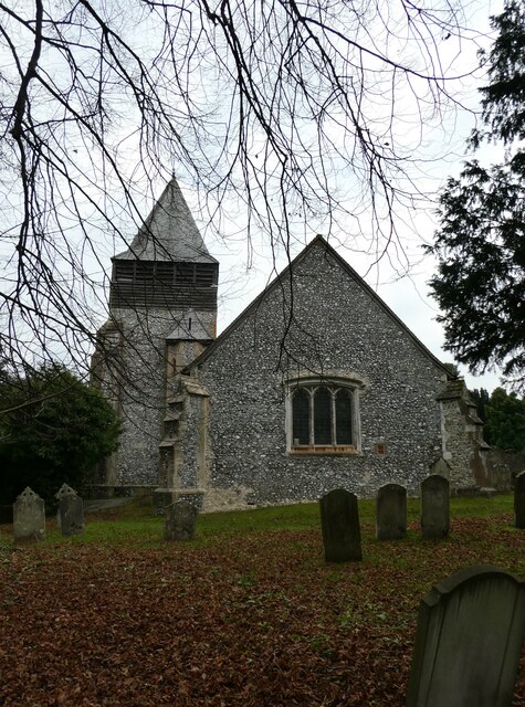
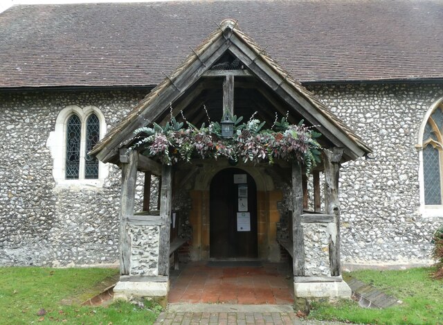
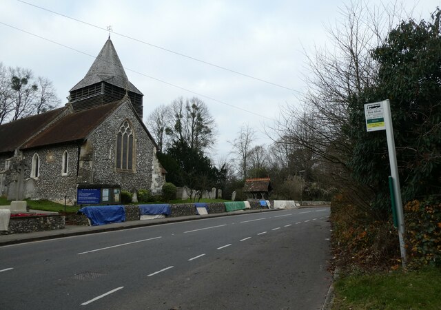
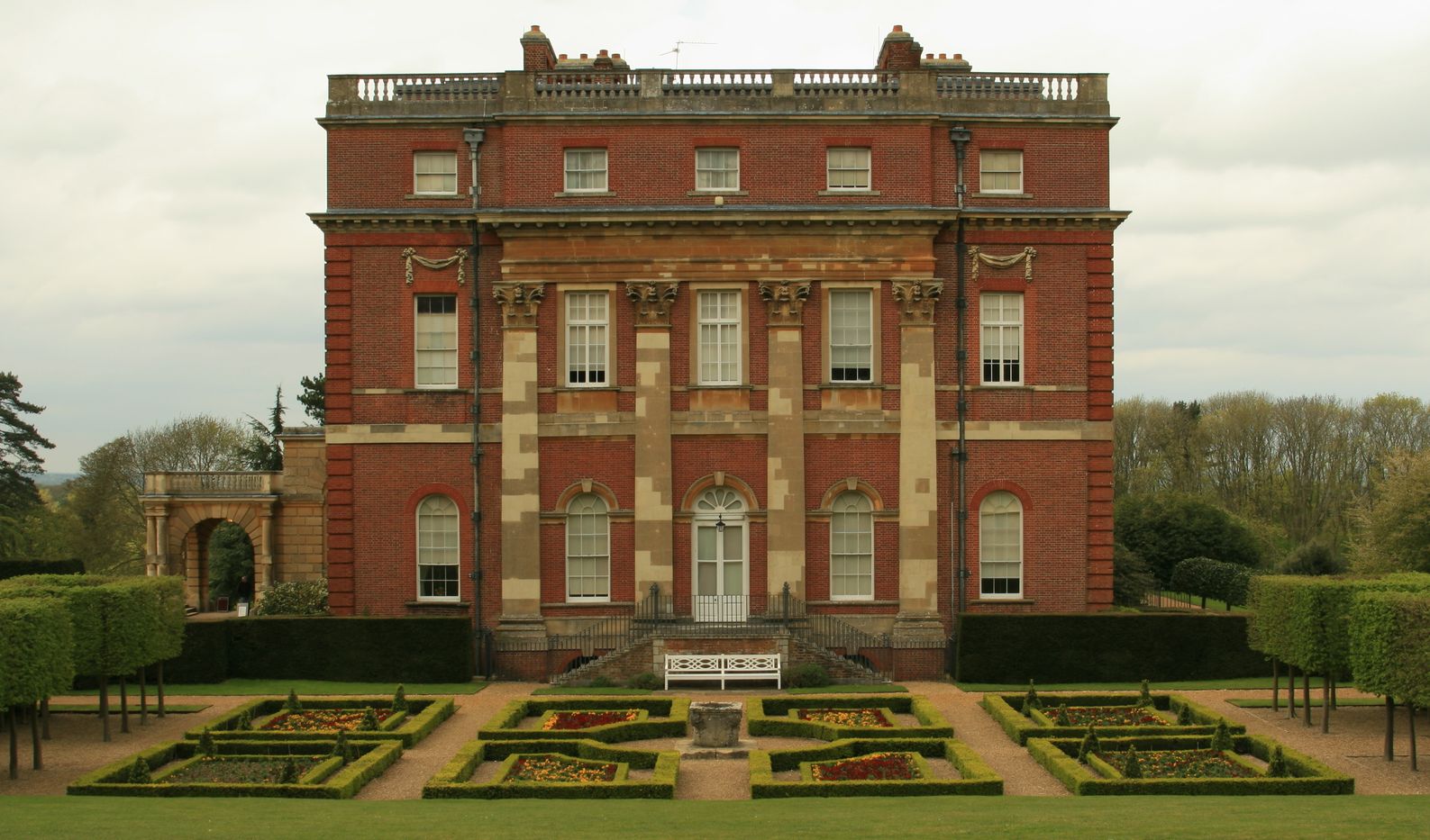
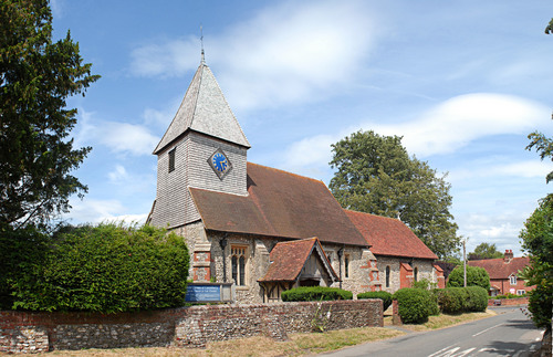
The village is known for its rich history, with evidence of human habitation dating back to the Bronze Age. It is home to several listed buildings, including the Grade I listed West Clandon House, a Palladian mansion built in the 1730s. The village also boasts a Grade II* listed church, St. Peter and St. Paul, which dates back to the 12th century.

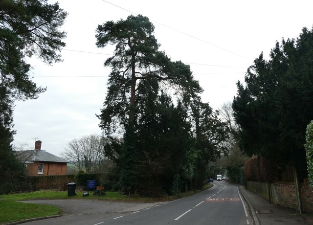
The surrounding countryside is characterized by rolling hills and open fields, providing a tranquil and scenic environment. The area is predominantly agricultural, with farming playing a significant role in the local economy.

West Clandon benefits from good transport links, with the A3 road passing nearby, connecting it to Guildford, London, and the south coast. The village is also served by a railway station, providing direct access to London Waterloo in under an hour.

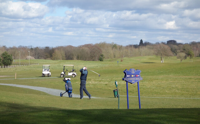
In terms of amenities, West Clandon has a primary school, a village hall, and a local pub. The village is close to several popular attractions, including Clandon Park, a National Trust property that offers visitors a glimpse into the area's history and architecture.

Overall, West Clandon is a charming and historic village, offering a peaceful countryside setting with easy access to larger towns and cities.

If you have any feedback on the listing, please let us know in the comments section below.

West Clandon Images

Images are sourced within 2km of 51.260834/-0.509077 or Grid Reference TQ0452. Thanks to Geograph Open Source API. All images are credited.

SS Peter & Paul, West Clandon: rear view
SS Peter & Paul, West Clandon: seasonal bower
SS Peter & Paul, West Clandon: CWGC grave For the service record of Bomabardier Evans see <span class="nowrap"><a title="https://www.cwgc.org/find-records/find-war-dead/casualty-details/401657/w-evans/" rel="nofollow ugc noopener" href="https://www.cwgc.org/find-records/find-war-dead/casualty-details/401657/w-evans/">Link</a><img style="margin-left:2px;" alt="External link" title="External link - shift click to open in new window" src="https://s1.geograph.org.uk/img/external.png" width="10" height="10"/></span>
SS Peter & Paul, West Clandon: CWGC grave
For the service record of Bomabardier Evans see LinkExternal link
SS Peter & Paul, West Clandon: names on the war memorial Many war memorials appeared in British towns and cities after the South African War of 1899-1902 (known popularly as the Boer War), but most were constructed after the First World War, known to contemporaries as the Great War (1914-19). These were updated after the Second World War (1939-45), usually by adding a plaque with the names of those killed in that conflict. Almost every town and village in Britain has a memorial erected after the Great War, the commonest types taking the form of a cross, an obelisk or a statue of a soldier. Some occupy a prominent public space; others stand in the local cemetery or can be found inside the local church. Memorials usually commemorate the inhabitants of a particular locality, the former pupils of a school, or the members of a military unit or branch of the armed forces. Other memorials, often bronze plaques placed indoors, commemorate the employees of a private company or public institution.
SS Peter & Paul, West Clandon: names on the war memorial
Many war memorials appeared in British towns and cities after the South African War of 1899-1902 (known popularly as the Boer War), but most were constructed after the First World War, known to contemporaries as the Great War (1914-19). These were updated after the Second World War (1939-45), usually by adding a plaque with the names of those killed in that conflict. Almost every town and village in Britain has a memorial erected after the Great War, the commonest types taking the form of a cross, an obelisk or a statue of a soldier. Some occupy a prominent public space; others stand in the local cemetery or can be found inside the local church. Memorials usually commemorate the inhabitants of a particular locality, the former pupils of a school, or the members of a military unit or branch of the armed forces. Other memorials, often bronze plaques placed indoors, commemorate the employees of a private company or public institution.
Bus stop opposite West Clandon Church
Looking south-southeast along the A247 Taken at West Clandon: also see <span class="nowrap"><a title="https://www.sabre-roads.org.uk/wiki/index.php?title=A247" rel="nofollow ugc noopener" href="https://www.sabre-roads.org.uk/wiki/index.php?title=A247">Link</a><img style="margin-left:2px;" alt="External link" title="External link - shift click to open in new window" src="https://s1.geograph.org.uk/img/external.png" width="10" height="10"/></span>
Looking south-southeast along the A247
Taken at West Clandon: also see LinkExternal link
Clandon House - Salvaged Meissen Cows Exhibit inside the fire-ravaged Palladian mansion. The National Trust offers guided tours inside the house shell.
Clandon House - Salvaged Meissen Cows
Exhibit inside the fire-ravaged Palladian mansion. The National Trust offers guided tours inside the house shell.
Clandon House - Fire Damage Ornate fireplace and red brick walls on show within the Palladian mansion which was gutted by fire in 2015.
Clandon House - Fire Damage
Ornate fireplace and red brick walls on show within the Palladian mansion which was gutted by fire in 2015.
Cirrus Clouds Marvellous midsummer suburban Surrey skies on a warm afternoon.
Cirrus Clouds
Marvellous midsummer suburban Surrey skies on a warm afternoon.
Clandon Park - London Maori Club Ngati Ranana, London Maori Club dancer outside the shell of Hinemihi, a Maori meeting house in the grounds of Clandon House.
The club aims to provide New Zealanders in the UK and others interested in Maori culture an environment to teach, learn and participate.
<span class="nowrap"><a title="www.ngatiranana.co.uk" rel="nofollow ugc noopener" href="http://www.ngatiranana.co.uk">Link</a><img style="margin-left:2px;" alt="External link" title="External link - shift click to open in new window" src="https://s1.geograph.org.uk/img/external.png" width="10" height="10"/></span>
Clandon Park - London Maori Club
Ngati Ranana, London Maori Club dancer outside the shell of Hinemihi, a Maori meeting house in the grounds of Clandon House. The club aims to provide New Zealanders in the UK and others interested in Maori culture an environment to teach, learn and participate. LinkExternal link
Clandon Park - London Maori Club Ngati Ranana, London Maori Club trio outside the shell of Hinemihi, a Maori meeting house in the grounds of Clandon House.
The club aims to provide New Zealanders in the UK and others interested in Maori culture an environment to teach, learn and participate.
<span class="nowrap"><a title="www.ngatiranana.co.uk" rel="nofollow ugc noopener" href="http://www.ngatiranana.co.uk">Link</a><img style="margin-left:2px;" alt="External link" title="External link - shift click to open in new window" src="https://s1.geograph.org.uk/img/external.png" width="10" height="10"/></span>
Clandon Park - London Maori Club
Ngati Ranana, London Maori Club trio outside the shell of Hinemihi, a Maori meeting house in the grounds of Clandon House. The club aims to provide New Zealanders in the UK and others interested in Maori culture an environment to teach, learn and participate. LinkExternal link
Clandon Park - London Maori Club Ngati Ranana, London Maori Club choir outside the shell of Hinemihi, a Maori meeting house in the grounds of Clandon House.
The club aims to provide New Zealanders in the UK and others interested in Maori culture an environment to teach, learn and participate.
<span class="nowrap"><a title="www.ngatiranana.co.uk" rel="nofollow ugc noopener" href="http://www.ngatiranana.co.uk">Link</a><img style="margin-left:2px;" alt="External link" title="External link - shift click to open in new window" src="https://s1.geograph.org.uk/img/external.png" width="10" height="10"/></span>
Clandon Park - London Maori Club
Ngati Ranana, London Maori Club choir outside the shell of Hinemihi, a Maori meeting house in the grounds of Clandon House. The club aims to provide New Zealanders in the UK and others interested in Maori culture an environment to teach, learn and participate. LinkExternal link
Clandon Park - London Maori Club Ngati Ranana, London Maori Club haka performance outside the shell of Hinemihi, a Maori meeting house in the grounds of Clandon House.
The club aims to provide New Zealanders in the UK and others interested in Maori culture an environment to teach, learn and participate.
<span class="nowrap"><a title="www.ngatiranana.co.uk" rel="nofollow ugc noopener" href="http://www.ngatiranana.co.uk">Link</a><img style="margin-left:2px;" alt="External link" title="External link - shift click to open in new window" src="https://s1.geograph.org.uk/img/external.png" width="10" height="10"/></span>
Clandon Park - London Maori Club
Ngati Ranana, London Maori Club haka performance outside the shell of Hinemihi, a Maori meeting house in the grounds of Clandon House. The club aims to provide New Zealanders in the UK and others interested in Maori culture an environment to teach, learn and participate. LinkExternal link
Clandon Park - London Maori Club Ngati Ranana, London Maori Club expressive haka performer outside the shell of Hinemihi, a Maori meeting house in the grounds of Clandon House.
The club aims to provide New Zealanders in the UK and others interested in Maori culture an environment to teach, learn and participate.
<span class="nowrap"><a title="www.ngatiranana.co.uk" rel="nofollow ugc noopener" href="http://www.ngatiranana.co.uk">Link</a><img style="margin-left:2px;" alt="External link" title="External link - shift click to open in new window" src="https://s1.geograph.org.uk/img/external.png" width="10" height="10"/></span>
Clandon Park - London Maori Club
Ngati Ranana, London Maori Club expressive haka performer outside the shell of Hinemihi, a Maori meeting house in the grounds of Clandon House. The club aims to provide New Zealanders in the UK and others interested in Maori culture an environment to teach, learn and participate. LinkExternal link
Merrow Common - Ice Needles Ice formations on twigs during a cold spell with air from the north - sensationalised this winter as "The Troll from Trondheim".
Merrow Common - Ice Needles
Ice formations on twigs during a cold spell with air from the north - sensationalised this winter as "The Troll from Trondheim".
Merrow Common - Ice Needles Ice formations on a holly leaf during a cold spell with air from the north - sensationalised this winter as "The Troll from Trondheim".
Merrow Common - Ice Needles
Ice formations on a holly leaf during a cold spell with air from the north - sensationalised this winter as "The Troll from Trondheim".
Clandon Golf Course
Clandon Golf Course
Show me another place!

West Clandon is located at Grid Ref: TQ0452 (Lat: 51.260834, Lng: -0.509077)

Administrative County: Surrey

District: Guildford

Police Authority: Surrey

What 3 Words

///exile.voted.bridge. Near West Clandon, Surrey

Related Wikis

West Clandon

West Clandon is a village in Surrey, England within 1 mile of the A3. It is situated one mile north west of the much smaller separate village of East Clandon...

Clandon railway station

Clandon railway station is located in the village of West Clandon in Surrey, England. It is 25 miles 26 chains (40.8 km) down the line from London Waterloo...

North Downs

The North Downs are a ridge of chalk hills in south east England that stretch from Farnham in Surrey to the White Cliffs of Dover in Kent. Much of the...

Clandon Park House

Clandon Park House is an early 18th-century grade I listed Palladian mansion in West Clandon, near Guildford in Surrey.It stands in the south east corner...

HM Prison Send

HM Prison Send is a closed category women's prison in the extreme south of Ripley nearer Send in Surrey, England. Its post town is Woking. The prison...

East Clandon

East Clandon is a village and civil parish in Surrey, England on the A246 between the towns of Guildford to the west and Leatherhead to the east. Neighbouring...

Merrow, Surrey

The village of Merrow in Surrey, England, is a suburb in the north-east of Guildford. It is 2 miles (3.2 km) from the town's centre, on the edge of the...

St Peter's Catholic School, Guildford

St Peter's Catholic School, colloquially known as St Peter's, is a co-educational secondary school and sixth form located in Guildford, Surrey, England...

Nearby Amenities

Located within 500m of 51.260834,-0.509077
Source: Landsat photo
Lat/Long: 51.2637182/-0.5052508
Source: Landsat photo
Lat/Long: 51.2632399/-0.5089517
Source: Landsat photo
Lat/Long: 51.2626247/-0.5121363
Royal British Legion
Building: yes
Entrance: yes
Lat/Long: 51.2606342/-0.5041554
Crossing
Crossing: traffic_signals
Crossing Island: no
Lat/Long: 51.2606629/-0.5032558
Post Box
Collection Times: Mo-Fr 09:00; Sa 07:00
Drive Through: no
Old Ref: GU4 122
Operator: Royal Mail
Post Box Type: wall
Postal Code: GU4
Ref: GU4 122D
Royal Cypher: EIIR
Royal Cypher Wikidata: Q33102113
Lat/Long: 51.2607013/-0.5030791
Telephone
Booth: K6
Fee: yes
Note: Proposal to remove sign / planning notice for same.
Phone: +44 1483 222494
Postal Code: GU4 7ST
Source: photo
Lat/Long: 51.2612931/-0.5038273
Note: FIXME: Malacca Farm is on the road sign. Where is it?
Source: photo
Lat/Long: 51.2643536/-0.504597
Bus Stop
Clandon Railway Station
Addr City: West Clandon
Addr Street: The Street
Bench: no
Bin: no
Lit: no
Naptan AtcoCode: 40004407257A
Naptan Bearing: N
Naptan CommonName: Clandon Railway Station
Naptan Indicator: Opp
Naptan Landmark: Clandon Station
Naptan NaptanCode: suraptgt
Naptan Street: The Street
Naptan Verified: yes
Public Transport: platform
Shelter: no
Source: naptan_import
Tactile Paving: no
Website: https://nextbuses.mobi/WebView/BusStopSearch/BusStopSearchResults/suraptgt
Wheelchair: limited
Wheelchair Description: Tactile crossing towards station. No easy step free route to stop opposite north of railway bridge.
Lat/Long: 51.2632424/-0.5047255
Bus Stop
Meadowlands
Naptan AtcoCode: 40004407258A
Naptan Bearing: N
Naptan CommonName: Meadowlands
Naptan Indicator: Just after
Naptan Landmark: Meadowlands
Naptan NaptanCode: suraptjd
Naptan Street: The Street
Naptan Verified: yes
Public Transport: platform
Source: naptan_import
Lat/Long: 51.26145/-0.5039922
Bus Stop
Meadowlands
Naptan AtcoCode: 40004407258B
Naptan Bearing: S
Naptan CommonName: Meadowlands
Naptan Indicator: Just Before
Naptan Landmark: Meadowlands
Naptan NaptanCode: suraptjg
Naptan Street: The Street
Naptan Verified: no
Public Transport: platform
Source: naptan_import
Lat/Long: 51.2603654/-0.5029374
Grit Bin
Lat/Long: 51.2635926/-0.5044375
Source: Landsat photo
Lat/Long: 51.2626583/-0.5121568
Source: Landsat photo
Lat/Long: 51.263275/-0.5089643
Source: Landsat photo
Lat/Long: 51.2637534/-0.5052622
Bench
Backrest: yes
Colour: green;black
Material: plastic;metal
Lat/Long: 51.2601863/-0.5041254
Access: yes
Hoops: 1
Leisure: pitch
Lit: no
Sport: basketball
Surface: grass
Lat/Long: 51.2596635/-0.5038282
Bench
Backrest: yes
Colour: black; green
Material: plastic;metal
Lat/Long: 51.2603037/-0.5041612
Leisure: picnic_table
Lat/Long: 51.2599887/-0.5041525
Leisure: picnic_table
Lat/Long: 51.2600397/-0.5041812
Defibrillator
Defibrillator Location: outside coded box on village hall wall, next to entrance on south side.
Emergency: defibrillator
Indoor: no
Ref: AAR70
Ref GB The Circuit: E2628F75-8E58-488F-9A63-AEA700DF0684
Lat/Long: 51.2608486/-0.503727
Leisure: playground
Lat/Long: 51.2600516/-0.5042754
Leisure: picnic_table
Lat/Long: 51.2602947/-0.5041942
Bench
Backrest: yes
Inscription: 2000
Material: wood
Lat/Long: 51.2604246/-0.5043628
Bench
Backrest: yes
Material: wood; metal
Lat/Long: 51.2607483/-0.5034372
Operator: UK Power Networks
Power: substation
Ref: MEADOWLANDS 171889
Lat/Long: 51.2607787/-0.5031613
Waste Basket
Lat/Long: 51.2601968/-0.5041266
Entrance: yes
Lat/Long: 51.2608543/-0.5037102
Entrance: yes
Lat/Long: 51.2609155/-0.503669
Advertising: board
Direction: 65
Lit: no
Operator: West Clandon Paris Council
Support: pole
Lat/Long: 51.2609811/-0.5035764
Leisure: fitness_station
Sport: fitness
Lat/Long: 51.2603768/-0.5040829
The data included in this document is from www.openstreetmap.org. The data is made available under ODbL.

Have you been to West Clandon?

Leave your review of West Clandon below (or comments, questions and feedback).