Upton Hellions

Civil Parish in Devon Mid Devon

England

Upton Hellions

Footpath to Shobrooke Crosses this field.
Footpath to Shobrooke Credit: Jonathan Thacker

Upton Hellions is a civil parish located in Devon, a county in southwestern England. Situated approximately 5 miles northwest of Exeter, the parish covers an area of around 4 square miles. Upton Hellions is a rural area characterized by its picturesque countryside, rolling hills, and charming agricultural landscapes.

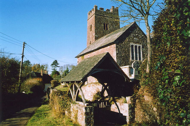
The parish is home to a small population, with only a handful of residential properties scattered across the area. The village of Upton Hellions itself consists of a few houses and a historic church, St. Mary's, which dates back to the 12th century.

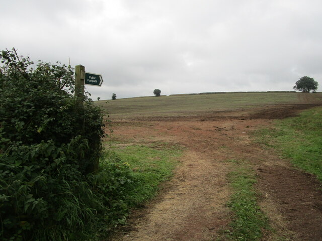
The landscape surrounding Upton Hellions is predominantly agricultural, with farmlands used for crop cultivation and livestock rearing. The area is known for its fertile soil and has a long history of agricultural practices.

Upton Hellions is surrounded by other small villages, including Shillingford Abbot to the south and Shillingford St. George to the east. The parish is well-connected to the rest of Devon via local roads, making it easily accessible for visitors and residents alike.

The tranquility and natural beauty of Upton Hellions make it a popular destination for outdoor activities such as hiking, cycling, and nature walks. The surrounding countryside offers stunning views and opportunities to explore the diverse flora and fauna of the region.

In conclusion, Upton Hellions is a charming rural parish in Devon, England, known for its peaceful atmosphere, agricultural landscapes, and historic church. It provides a serene escape from the bustling city life, making it an ideal destination for those seeking a countryside experience.

If you have any feedback on the listing, please let us know in the comments section below.

Upton Hellions Images

Images are sourced within 2km of 50.813117/-3.640414 or Grid Reference SS8402. Thanks to Geograph Open Source API. All images are credited.

Footpath to Shobrooke Crosses this field.
Footpath to Shobrooke
Crosses this field.
Sandford Congregational church
Milestone north of Sandford The milestone reads "10 miles to Exeter".  As the next town is Crediton, one wonders why the distance to Exeter was recorded.
Milestone north of Sandford
The milestone reads "10 miles to Exeter". As the next town is Crediton, one wonders why the distance to Exeter was recorded.
Road north of Sandford There is a milestone "10 miles to Exeter" in the grass on the right hand bank of the road. <a href="https://www.geograph.org.uk/photo/2379938">SS8203 : Milestone north of Sandford</a>
Road north of Sandford
There is a milestone "10 miles to Exeter" in the grass on the right hand bank of the road. SS8203 : Milestone north of Sandford
Footpath south of Sturridge
Pond beside footpath south of Sturridge
Farm gate on public footpath north of Sandford
Footpath beside freshly planted field The footpath leads west between two roads which lead north from Sandford.
Footpath beside freshly planted field
The footpath leads west between two roads which lead north from Sandford.
Northlakes north of Sandford
Track to Venn farm
Track to Venn farm
Lower Creedy seen across the Creedy valley
Upton Hellions seen across the Creedy valley
Signpost at Fannys Lane Cross
Sandford Village Hall and car park The hall is on the east of the village
Sandford Village Hall and car park
The hall is on the east of the village
Road to Lower Creedy across the Creedy valley
Lower Creedy Bridge over River Creedy
Road to Lower Creedy The verge of the road is lined with cow-parsley, passing a small barn on the north side of the road.
Road to Lower Creedy
The verge of the road is lined with cow-parsley, passing a small barn on the north side of the road.
Middleways between Lower Creedy and Upton Hellions
Show me another place!

Upton Hellions is located at Grid Ref: SS8402 (Lat: 50.813117, Lng: -3.640414)

Administrative County: Devon

District: Mid Devon

Police Authority: Devon & Cornwall

What 3 Words

///names.racetrack.backers. Near Crediton, Devon

Related Wikis

Upton Hellions

Upton Hellions is a village in Devon, England, located north of Long Barn and south of East Village, and near to Crediton. == External links == Media...

Sandford, Devon

Sandford is a village and civil parish in the Mid Devon district, within Devon, England. Sandford is part of the electoral ward named Sandford and Creedy...

Creedy, Sandford

Creedy is an historic estate in the parish of Sandford, near Crediton in Devon. It is named from its location on the west side of the River Creedy. It...

Little Fulford

Little Fulford was an historic estate in the parishes of Shobrooke and Crediton, Devon. It briefly share ownership before 1700 with Great Fulford, in Dunsford...

Nearby Amenities

Located within 500m of 50.813117,-3.640414
Power: pole
Source: bing
Lat/Long: 50.8115034/-3.6452468
Power: pole
Source: bing
Lat/Long: 50.8120305/-3.6456451
Power: pole
Source: bing
Lat/Long: 50.8118059/-3.645511
Power: pole
Source: bing
Lat/Long: 50.8135193/-3.6464283
Power: pole
Source: bing
Lat/Long: 50.8144209/-3.6468333
Power: pole
Source: bing
Lat/Long: 50.8148937/-3.6465061
Power: pole
Source: bing
Lat/Long: 50.8155716/-3.6459374
Power: pole
Source: bing
Lat/Long: 50.8161851/-3.6455083
Power: pole
Source: bing
Lat/Long: 50.8126448/-3.6459991
Power: pole
Source: bing
Lat/Long: 50.8125855/-3.6471498
Post Box
Operator: Royal Mail
Post Box Type: wall
Ref: EX17 12D
Royal Cypher: VR
Royal Cypher Wikidata: Q33102356
Lat/Long: 50.812262/-3.6448094
Generator Method: photovoltaic
Generator Output Electricity: yes
Generator Source: solar
Generator Type: solar_photovoltaic_panel
Power: generator
Lat/Long: 50.8118494/-3.6445412
The data included in this document is from www.openstreetmap.org. The data is made available under ODbL.

Have you been to Upton Hellions?

Leave your review of Upton Hellions below (or comments, questions and feedback).