Thormanby

Civil Parish in Yorkshire Hambleton

England

Thormanby

Near Thormanby Looking NE from Church Lane.
Near Thormanby Credit: T Eyre

Thormanby is a civil parish located in the county of Yorkshire, England. Situated approximately 10 miles north of the city of York, it is a small rural community with a population of around 200 residents.

The parish is nestled in a picturesque countryside setting, surrounded by rolling hills and lush green fields. It covers an area of approximately 4 square miles and is predominantly an agricultural area, with farming being the main occupation of the local residents.

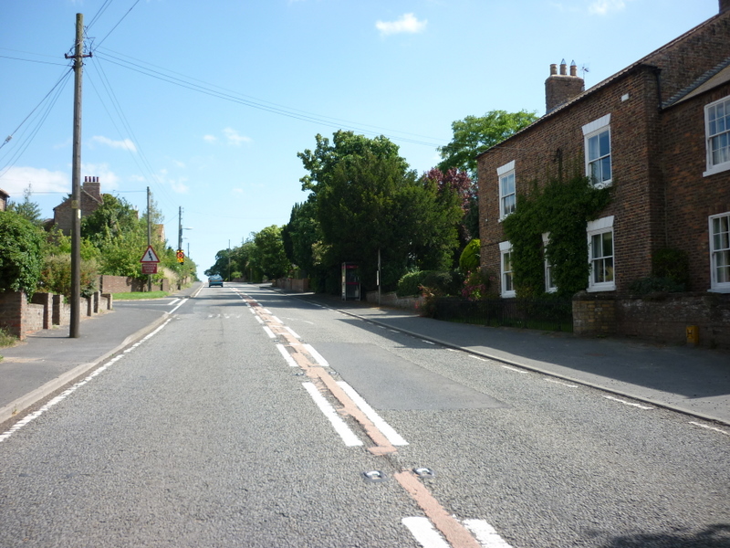
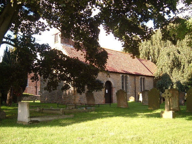
Thormanby is known for its charming village atmosphere and close-knit community. The village itself features a scattering of traditional stone cottages, a village hall, and a small church, which dates back to the 12th century and is dedicated to St Mary. The church, with its beautiful stained glass windows and historic architecture, is a notable landmark in the area.

The local economy is primarily centered around agriculture, with many farms in the area producing crops such as wheat, barley, and oats. Livestock farming, particularly sheep and cattle rearing, is also prevalent.

Thormanby offers a tranquil and scenic environment, making it a popular destination for nature enthusiasts and walkers. The surrounding countryside provides numerous footpaths and bridleways, allowing residents and visitors to explore the stunning landscapes and enjoy the peaceful ambiance of the area.

Overall, Thormanby is a charming rural parish in Yorkshire, offering a peaceful and idyllic lifestyle for its residents, and attracting visitors with its natural beauty and quaint village charm.

If you have any feedback on the listing, please let us know in the comments section below.

Thormanby Images

Images are sourced within 2km of 54.163967/-1.24644 or Grid Reference SE4974. Thanks to Geograph Open Source API. All images are credited.

Near Thormanby Looking NE from Church Lane.
Near Thormanby
Looking NE from Church Lane.
Thormanby church The church at Thormanby.
Thormanby church
The church at Thormanby.
Old milepost This milepost used to stand a few hundred yards to the south of its present site, opposite the start of the sliproad into New Road and south of the lane to Husthwaite.   In 2018 it was the casualty of a vehicle strike.  Several pieces were found in the ditch with Cleveland Corrosion replacing lost pieces and mending the post.  It has taken until October 2022 for it to be reset by the roadside.  It could not be put back at its original site as underground services had been set through the verge.
Old milepost
This milepost used to stand a few hundred yards to the south of its present site, opposite the start of the sliproad into New Road and south of the lane to Husthwaite. In 2018 it was the casualty of a vehicle strike. Several pieces were found in the ditch with Cleveland Corrosion replacing lost pieces and mending the post. It has taken until October 2022 for it to be reset by the roadside. It could not be put back at its original site as underground services had been set through the verge.
Old milepost Looking north along the A19 with New Road off to the right at the pole bearing signs for entering the A19 and beyond, the sign for the right turn to Husthwaite.
Old milepost
Looking north along the A19 with New Road off to the right at the pole bearing signs for entering the A19 and beyond, the sign for the right turn to Husthwaite.
Approaching  Thormanby  on  A19  northbound
Approaching Thormanby on A19 northbound
The  A19  through  the  middle  of  Thormanby A new build on the right
The A19 through the middle of Thormanby
A new build on the right
Little Sessay, Fullans Farm According to the OS benchmark database there is a benchmark cut into a north-east facing wall of one of the farm's outbuildings. The route of the footpath and the dense vegetation did not allow any view of the building.
Little Sessay, Fullans Farm
According to the OS benchmark database there is a benchmark cut into a north-east facing wall of one of the farm's outbuildings. The route of the footpath and the dense vegetation did not allow any view of the building.
Thormanby, Mill Lane According to the OS benchmark database there was a concrete gatepost at this field entrance with a cutmark. Both posts are now wooden.
Thormanby, Mill Lane
According to the OS benchmark database there was a concrete gatepost at this field entrance with a cutmark. Both posts are now wooden.
Thormanby, Mill Lane According to the OS benchmark database there was a cutmark in the bridge parapet on the north side of the lane. There is no parapet amongst the thick vegetation.
Thormanby, Mill Lane
According to the OS benchmark database there was a cutmark in the bridge parapet on the north side of the lane. There is no parapet amongst the thick vegetation.
Thormanby, Mill Lane According to the OS benchmark database there was a wooden gatepost at this field entrance with a cutmark. The area is used for parking and no wooden gateposts remain.
Thormanby, Mill Lane
According to the OS benchmark database there was a wooden gatepost at this field entrance with a cutmark. The area is used for parking and no wooden gateposts remain.
Thormanby, Moor Lane According to the OS benchmark database there was a field entrance this side of the hedge to gain access to the field on the right. The gatepost had a cutmark. Both the field entrance and gateposts have gone.
Thormanby, Moor Lane
According to the OS benchmark database there was a field entrance this side of the hedge to gain access to the field on the right. The gatepost had a cutmark. Both the field entrance and gateposts have gone.
Thormanby, Moor Lane, barn conversion According to the OS benchmark database there is OS Flush Bracket G3285 embedded into a farm barn at this location. Buildings have been converted to homes and nothing was found.
Thormanby, Moor Lane, barn conversion
According to the OS benchmark database there is OS Flush Bracket G3285 embedded into a farm barn at this location. Buildings have been converted to homes and nothing was found.
Thormanby, Old Black Bull PH According to the OS benchmark database there is a benchmark cut into the road facing wall of the converted pub. The cutmark is to the left of the bow window, behind the bush and nothing could be seen from the roadside. The pub closed in 2000.
Thormanby, Old Black Bull PH
According to the OS benchmark database there is a benchmark cut into the road facing wall of the converted pub. The cutmark is to the left of the bow window, behind the bush and nothing could be seen from the roadside. The pub closed in 2000.
Thormanby, St Mary's church The benchmark is cut into a left cornerstone of the north-east facing wall of the church. This is the rear gable end of the church.
Thormanby, St Mary's church
The benchmark is cut into a left cornerstone of the north-east facing wall of the church. This is the rear gable end of the church.
Thormanby, St Mary's church There is a benchmark cut into a left cornerstone of the north-east facing wall of the church. This is the rear gable end of the church.
Thormanby, St Mary's church
There is a benchmark cut into a left cornerstone of the north-east facing wall of the church. This is the rear gable end of the church.
Farmland off New Road
New Road towards the A19
Cold Harbour Farm
Cold Harbour Farm
Show me another place!

Thormanby is located at Grid Ref: SE4974 (Lat: 54.163967, Lng: -1.24644)

Division: North Riding

Administrative County: North Yorkshire

District: Hambleton

Police Authority: North Yorkshire

What 3 Words

///miss.likewise.deflation. Near Easingwold, North Yorkshire

Related Wikis

Thormanby

Thormanby is a village and civil parish in Hambleton District of North Yorkshire, England. It lies on the A19 approximately halfway between Easingwold...

St Mary's Church, Birdforth

St Mary's Church, or Birdforth Old Chapel, is a former Anglican church in the village of Birdforth, North Yorkshire, England. It is recorded in the National...

Birdforth

Birdforth is a village and civil parish in the Hambleton district of North Yorkshire, England. According to the 2001 census it had a population of 13...

Carlton Husthwaite

Carlton Husthwaite is a village and civil parish in the Hambleton district of North Yorkshire, England, about seven miles south-east of Thirsk. According...

Nearby Amenities

Located within 500m of 54.163967,-1.24644
Old Phone: +44 1845 501211
Removed Amenity: telephone
Lat/Long: 54.1677402/-1.2471079
Bus Stop
Departures Board: timetable
Note: No flag, but timetable is on a post
Lat/Long: 54.167778/-1.2471672
Post Box
Post Box Type: lamp
Ref: YO61 94
Royal Cypher: EIIR
Royal Cypher Wikidata: Q33102113
Lat/Long: 54.1677148/-1.2468455
Board: parish
Information: board
Tourism: information
Lat/Long: 54.1679123/-1.2468053
Defibrillator
Defibrillator Location: outside, attached to wall, opposite where Wentworth Avenue joins A19 in Thormanby
Emergency: defibrillator
Indoor: no
Ref GB The Circuit: 0AFE3BB8-A3B6-4DB0-9176-AF8800AB26CF
Lat/Long: 54.1677915/-1.2472363
Passing Place
Lat/Long: 54.1650913/-1.2493788
The data included in this document is from www.openstreetmap.org. The data is made available under ODbL.

Have you been to Thormanby?

Leave your review of Thormanby below (or comments, questions and feedback).