Swinbrook and Widford

Civil Parish in Oxfordshire West Oxfordshire

England

Swinbrook and Widford

Walls and Trees near Asthall A timeless old style farming landscape in the Windrush valley.
Walls and Trees near Asthall Credit: Des Blenkinsopp

Swinbrook and Widford is a civil parish located in the county of Oxfordshire, England. It is situated in the Cotswolds, an area known for its picturesque landscapes and charming villages. The parish encompasses the small villages of Swinbrook and Widford, which are situated approximately two miles apart.

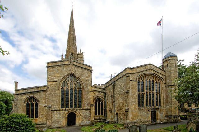
Swinbrook is a quintessential Cotswold village, with its stone cottages and traditional architecture. It is perhaps most famous for its 17th-century pub, The Swan Inn, which has been a popular destination for locals and tourists alike. The village is also home to the Church of St. Mary, a medieval church known for its historic and architectural significance.

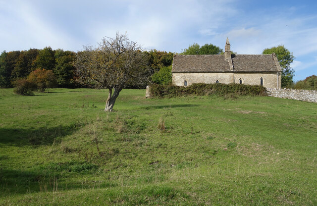
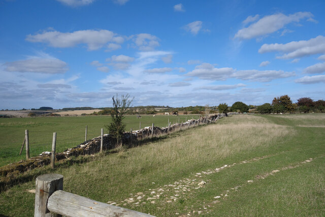
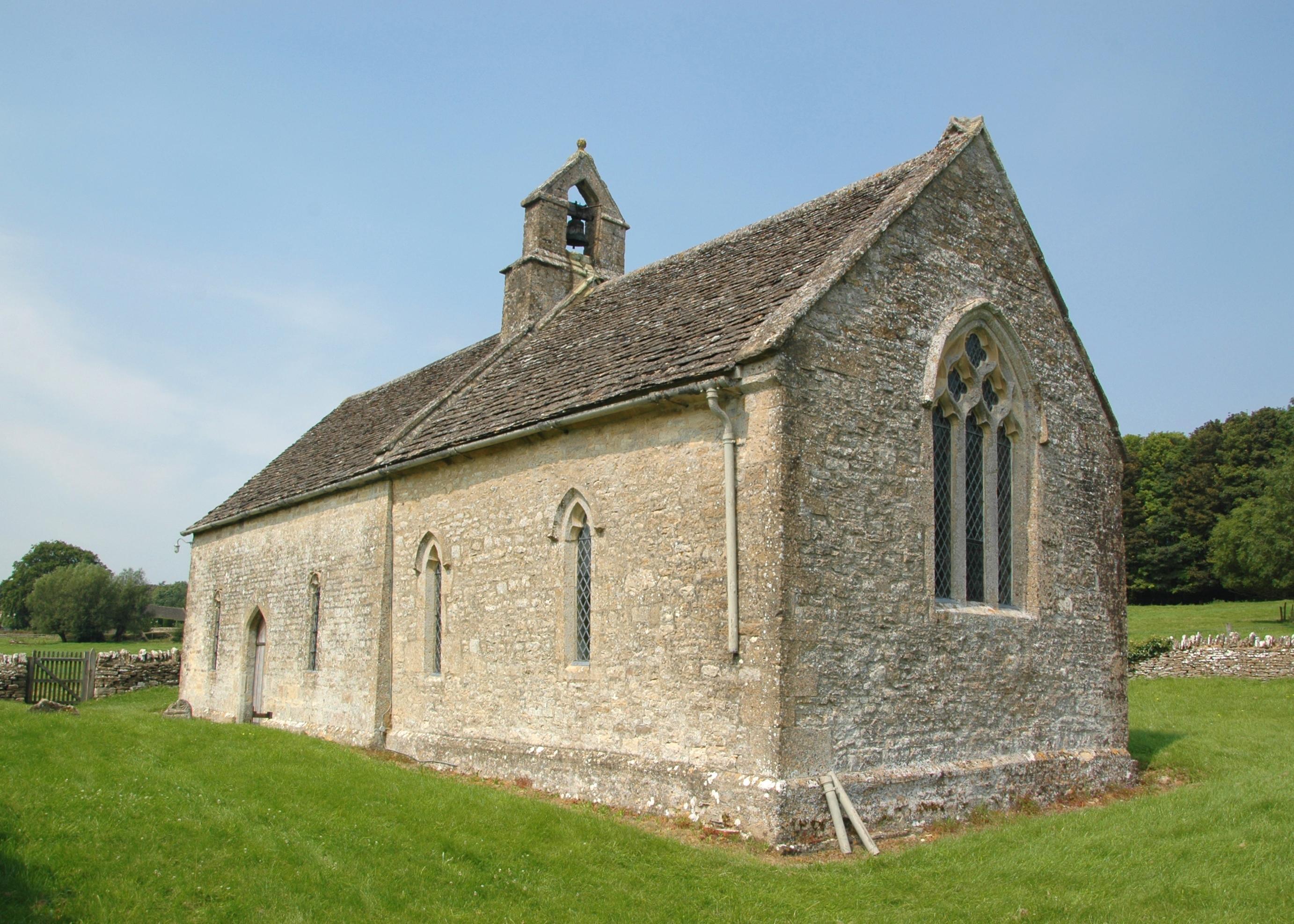
Widford, on the other hand, is a smaller village with a more rural feel. It is surrounded by rolling hills and farmland, offering stunning views of the Oxfordshire countryside. The village is home to a number of traditional thatched cottages, giving it a quaint and idyllic atmosphere.

Both Swinbrook and Widford benefit from their proximity to the River Windrush, which flows through the area. This provides ample opportunities for outdoor activities such as fishing, boating, and picnicking along the riverbanks.

The civil parish of Swinbrook and Widford offers a peaceful and picturesque setting, making it a popular destination for those seeking a rural escape. Whether exploring the historic architecture, enjoying the natural beauty, or simply soaking in the traditional village atmosphere, visitors are sure to find charm and tranquility in this Oxfordshire gem.

If you have any feedback on the listing, please let us know in the comments section below.

Swinbrook and Widford Images

Images are sourced within 2km of 51.815132/-1.594867 or Grid Reference SP2813. Thanks to Geograph Open Source API. All images are credited.

Walls and Trees near Asthall A timeless old style farming landscape in the Windrush valley.
Walls and Trees near Asthall
A timeless old style farming landscape in the Windrush valley.
Hillside at Kitesbridge Farm Sloping up out of the Windrush Valley.
Hillside at Kitesbridge Farm
Sloping up out of the Windrush Valley.
A Stile and a Gate The old gate is long disused and falling to bits. The stone stile is in much better shape.
Footpath north of Asthall Bridge.
A Stile and a Gate
The old gate is long disused and falling to bits. The stone stile is in much better shape. Footpath north of Asthall Bridge.
Digger in the Gateway This mechanical arm suddenly appeared as I was about to walk past.
Digger in the Gateway
This mechanical arm suddenly appeared as I was about to walk past.
Red Creeper on the Wall Seasonal colour in Asthall Village.
Red Creeper on the Wall
Seasonal colour in Asthall Village.
Thatched House, Asthall Houses and sheep in Asthall Village.
Thatched House, Asthall
Houses and sheep in Asthall Village.
Width restriction into Asthall At the edge of the village. Smart white fencing to look nice and solid metal posts to stop oversized vehicles.
Width restriction into Asthall
At the edge of the village. Smart white fencing to look nice and solid metal posts to stop oversized vehicles.
Old Lantern by the Churchyard One of the ways to Swinbrook Church is up some steps into the churchyard from the road.
This lamp is at the top of the steps.
Old Lantern by the Churchyard
One of the ways to Swinbrook Church is up some steps into the churchyard from the road. This lamp is at the top of the steps.
Swinbrook Village Hall In the centre of the village over the road from the church.
The old lamp is by a gate into the churchyard.
Swinbrook Village Hall
In the centre of the village over the road from the church. The old lamp is by a gate into the churchyard.
Early Autumn in Swinbrook A mid October day in this pleasant Cotswold village.
Early Autumn in Swinbrook
A mid October day in this pleasant Cotswold village.
Stone Tombs in Swinbrook Churchyard There are quite a few of these elaborate stone tombs in the churchyard.
Stone Tombs in Swinbrook Churchyard
There are quite a few of these elaborate stone tombs in the churchyard.
Track to Bockett's Corner A continuation of the road up from Asthall which has remained unsurfaced.
A winter picture of the same scene is on <a href="https://www.geograph.org.uk/photo/327336">SP2912 : Track to Bockett's Corner</a>
According to my map, the track changes status half way along, with the southern part being officially a byway open to all traffic while the north end is just a bridleway.
The change is at the site of a former quarry.
Track to Bockett's Corner
A continuation of the road up from Asthall which has remained unsurfaced. A winter picture of the same scene is on SP2912 : Track to Bockett's Corner According to my map, the track changes status half way along, with the southern part being officially a byway open to all traffic while the north end is just a bridleway. The change is at the site of a former quarry.
Crossways near Asthall The road between Swinbrook and Asthall Leigh, with a junction to Asthall on the right and an unsurfaced byway opposite.
Crossways near Asthall
The road between Swinbrook and Asthall Leigh, with a junction to Asthall on the right and an unsurfaced byway opposite.
St Oswald's Church, Widford Present day Widford consists of only a handful of properties but in medieval times there was a village here. 
Thought to have been a casualty of the 14th century Black Death pandemic, the village never recovered. Remains of the site are still visible in the fields round the church and can be seen in this picture.
The church survived and is still in use. 
St Oswald was a 7th century Saxon king of Northumbria who despite involvement in various battles, by the standards of the time was thought to be saintly. A church dedication in this part of the country is unusual. One of Oswald's relatives founded a priory in Gloucester and dedicated it to him. Widford was part of its estate.
The parish remained an outlying part of Gloucestershire until 1844 when it was incorporated into surrounding Oxfordshire.
St Oswald's Church, Widford
Present day Widford consists of only a handful of properties but in medieval times there was a village here. Thought to have been a casualty of the 14th century Black Death pandemic, the village never recovered. Remains of the site are still visible in the fields round the church and can be seen in this picture. The church survived and is still in use. St Oswald was a 7th century Saxon king of Northumbria who despite involvement in various battles, by the standards of the time was thought to be saintly. A church dedication in this part of the country is unusual. One of Oswald's relatives founded a priory in Gloucester and dedicated it to him. Widford was part of its estate. The parish remained an outlying part of Gloucestershire until 1844 when it was incorporated into surrounding Oxfordshire.
Cows at Widford This meadow is the site of the deserted medieval village of Widford, a settlement which never recovered from the Black Death plague in the 14th century. The remains of the village still show up as slight hills and hollows in the grass.
Cows at Widford
This meadow is the site of the deserted medieval village of Widford, a settlement which never recovered from the Black Death plague in the 14th century. The remains of the village still show up as slight hills and hollows in the grass.
Between Swinbrook and Fulbrook Fields and old walls along a country lane.
Between Swinbrook and Fulbrook
Fields and old walls along a country lane.
Berries on the Wall An assortment of plants scramble over a neglected stone wall along a lane near Swinbrook.
Berries on the Wall
An assortment of plants scramble over a neglected stone wall along a lane near Swinbrook.
A Well Fenced Wall Maintaining old dry stone walls is a laborious and expensive business and nowadays is usually only done for cosmetic reasons.
Out in the fields, post and wire fencing is a lot easier. This wall is fenced on both sides.
A Well Fenced Wall
Maintaining old dry stone walls is a laborious and expensive business and nowadays is usually only done for cosmetic reasons. Out in the fields, post and wire fencing is a lot easier. This wall is fenced on both sides.
Show me another place!

Swinbrook and Widford is located at Grid Ref: SP2813 (Lat: 51.815132, Lng: -1.594867)

Administrative County: Oxfordshire

District: West Oxfordshire

Police Authority: Thames Valley

What 3 Words

///stems.musician.ants. Near Burford, Oxfordshire

Related Wikis

Swinbrook

Swinbrook is a village and former civil parish, now in the parish of Swinbrook and Widford, in the West Oxfordshire district, in the county of Oxfordshire...

Swinbrook and Widford

Swinbrook and Widford is a civil parish in West Oxfordshire district, in the county of Oxfordshire, England. It comprises the village of Swinbrook and...

Widford, Oxfordshire

Widford is a deserted medieval village on the River Windrush about 1.5 miles (2.4 km) east of Burford in West Oxfordshire. The village was an exclave of...
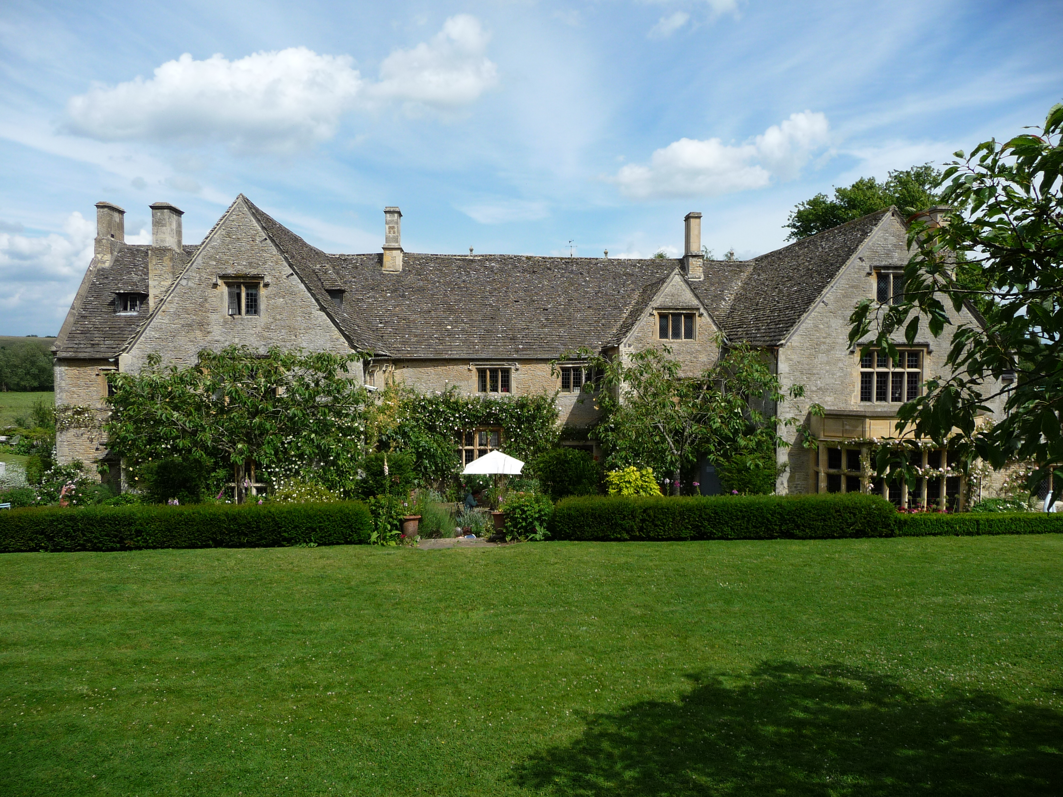
Asthall Manor

Asthall Manor is a gabled Jacobean Cotswold manor house in Asthall, Oxfordshire. It was built in about 1620 and altered and enlarged in about 1916. The...

Asthall

Asthall or Asthal is a village and civil parish on the River Windrush in Oxfordshire, about 6 miles (10 km) west of Witney. It includes the hamlets of...

Fulbrook, Oxfordshire

Fulbrook is a village and civil parish immediately northeast of Burford in West Oxfordshire. The 2011 Census recorded the parish's population as 437....

Church of St John the Baptist, Burford

The Anglican Church of St John the Baptist in Burford, Oxfordshire, England is a Grade I listed building.The Church of England parish church is dedicated...

Burford Methodist Church

Burford Methodist Church is a baroque building in the High Street of Burford, Oxfordshire. It was built between about 1715 and 1730 as a private house...

Nearby Amenities

Located within 500m of 51.815132,-1.594867
Fordwell Turn
Naptan AtcoCode: 340000738FT
Naptan Bearing: NW
Naptan BusStopType: CUS
Naptan CommonName: Fordwell Turn
Naptan Indicator: Northbound
Naptan Landmark: Hit or Miss Cottage
Naptan NaptanCode: oxfapatw
Naptan Street: unclassified road
Naptan Verified: no
Source: naptan_import
Lat/Long: 51.8169098/-1.5893963
Fordwell Turn
Naptan AtcoCode: 340000738FTS
Naptan Bearing: SW
Naptan BusStopType: CUS
Naptan CommonName: Fordwell Turn
Naptan Indicator: Southbound
Naptan Landmark: Hit or Miss Cottage
Naptan NaptanCode: oxfgajgd
Naptan Street: unclassified road
Naptan Verified: no
Source: naptan_import
Lat/Long: 51.8168823/-1.589237
Power: pole
Lat/Long: 51.8193436/-1.5962855
Power: pole
Lat/Long: 51.818765/-1.5942256
Power: pole
Lat/Long: 51.8183954/-1.593253
Power: pole
Lat/Long: 51.8182516/-1.5928125
Power: pole
Lat/Long: 51.8116104/-1.5968988
Power: pole
Lat/Long: 51.8134569/-1.6009166
Power: pole
Lat/Long: 51.8132187/-1.5996746
Power: pole
Lat/Long: 51.8129943/-1.5984307
Power: pole
Lat/Long: 51.8122744/-1.5976182
Power: pole
Lat/Long: 51.8191272/-1.5952481
Post Box
Operator: Royal Mail
Post Box Type: lamp
Ref: OX18 423D
Royal Cypher: EIIR
Lat/Long: 51.8136282/-1.5929747
The data included in this document is from www.openstreetmap.org. The data is made available under ODbL.

Have you been to Swinbrook and Widford?

Leave your review of Swinbrook and Widford below (or comments, questions and feedback).