All Cannings
Settlement in Wiltshire
England
All Cannings
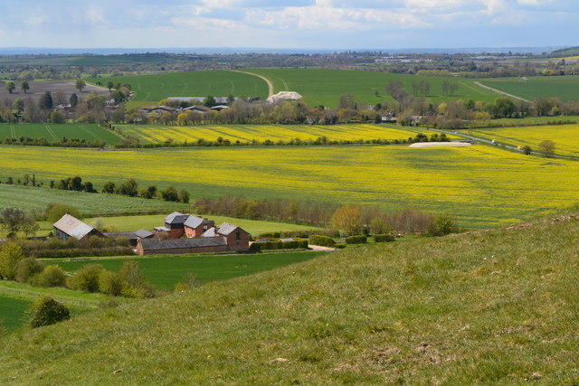
![A walk from Allington to the Wansdyke and back [1] The bridleway approaches the Kennet and Avon Canal.
The walk leaves Allington and goes south to run along the towpath of the Kennet and Avon Canal before turning north to cross the minor road at Cannings Cross. Ascending steeply, the path leads to the causewayed enclosure and hillfort of Rybury atop Clifford’s Hill. After a short descent, there is a long climb up Tan Hill to the Wansdyke. A short way along the dyke, the return journey starts, a long descent down a well surfaced track, a public bridleway, to Allington. Just over 4½ miles.](https://s1.geograph.org.uk/geophotos/07/36/37/7363773_f6531b1e.jpg)
All Cannings is a small village located in the county of Wiltshire, England. Situated approximately 4 miles southeast of the town of Devizes, it lies within the picturesque Vale of Pewsey. The village is surrounded by rolling countryside, offering stunning views of the Wiltshire Downs.
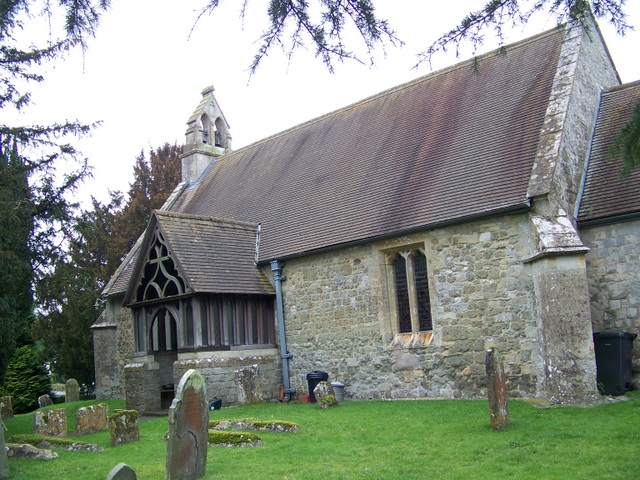
With a population of around 800 residents, All Cannings is a close-knit community known for its peaceful and friendly atmosphere. The village features a traditional English parish church, St. Anne's, which dates back to the 12th century and is a significant historical landmark.
A prominent feature of All Cannings is its charming village green, a well-maintained open space where locals often gather for recreational activities and community events. The village also boasts a primary school, a village hall, and a local pub, The Kings Arms, which serves as a social hub for residents and visitors alike.
All Cannings offers an array of amenities to cater to the needs of its residents, including a post office, a convenience store, and a popular tea room. The surrounding countryside provides ample opportunities for outdoor activities such as walking, cycling, and horse riding, making it an ideal location for nature enthusiasts.
The village is well-connected by road, with easy access to the nearby towns of Devizes and Marlborough, as well as the wider Wiltshire area. All Cannings offers a peaceful and idyllic rural lifestyle while still providing convenient access to essential services and amenities.
If you have any feedback on the listing, please let us know in the comments section below.
All Cannings Images
Images are sourced within 2km of 51.356498/-1.897442 or Grid Reference SU0761. Thanks to Geograph Open Source API. All images are credited.
![A walk from Allington to the Wansdyke and back [2] This swing bridge carries the bridleway over the Kennet and Avon Canal.
The walk leaves Allington and goes south to run along the towpath of the Kennet and Avon Canal before turning north to cross the minor road at Cannings Cross. Ascending steeply, the path leads to the causewayed enclosure and hillfort of Rybury atop Clifford’s Hill. After a short descent, there is a long climb up Tan Hill to the Wansdyke. A short way along the dyke, the return journey starts, a long descent down a well surfaced track, a public bridleway, to Allington. Just over 4½ miles.](https://s2.geograph.org.uk/geophotos/07/36/37/7363774_594bbe42.jpg)
![A walk from Allington to the Wansdyke and back [3] Boats along the Kennet and Avon Canal. Seen from the towpath.
The walk leaves Allington and goes south to run along the towpath of the Kennet and Avon Canal before turning north to cross the minor road at Cannings Cross. Ascending steeply, the path leads to the causewayed enclosure and hillfort of Rybury atop Clifford’s Hill. After a short descent, there is a long climb up Tan Hill to the Wansdyke. A short way along the dyke, the return journey starts, a long descent down a well surfaced track, a public bridleway, to Allington. Just over 4½ miles.](https://s3.geograph.org.uk/geophotos/07/36/37/7363775_6e5245be.jpg)
![A walk from Allington to the Wansdyke and back [4] 'Lest we forget' on a boat on the Kennet and Avon Canal.
The walk leaves Allington and goes south to run along the towpath of the Kennet and Avon Canal before turning north to cross the minor road at Cannings Cross. Ascending steeply, the path leads to the causewayed enclosure and hillfort of Rybury atop Clifford’s Hill. After a short descent, there is a long climb up Tan Hill to the Wansdyke. A short way along the dyke, the return journey starts, a long descent down a well surfaced track, a public bridleway, to Allington. Just over 4½ miles.](https://s2.geograph.org.uk/geophotos/07/36/37/7363778_0b0f2cf7.jpg)
![A walk from Allington to the Wansdyke and back [5] Perfectly reflected in the canal is Woodway Bridge. This accommodation bridge was built circa 1807 of brick with an oval arch. There is another image of the bridge at <a href="https://www.geograph.org.uk/photo/7363787">SU0762 : A walk from Allington to the Wansdyke and back [6]</a> Listed, grade II, with details at: <span class="nowrap"><a title="https://historicengland.org.uk/listing/the-list/list-entry/1033771" rel="nofollow ugc noopener" href="https://historicengland.org.uk/listing/the-list/list-entry/1033771">Link</a><img style="margin-left:2px;" alt="External link" title="External link - shift click to open in new window" src="https://s1.geograph.org.uk/img/external.png" width="10" height="10"/></span>
The walk leaves Allington and goes south to run along the towpath of the Kennet and Avon Canal before turning north to cross the minor road at Cannings Cross. Ascending steeply, the path leads to the causewayed enclosure and hillfort of Rybury atop Clifford’s Hill. After a short descent, there is a long climb up Tan Hill to the Wansdyke. A short way along the dyke, the return journey starts, a long descent down a well surfaced track, a public bridleway, to Allington. Just over 4½ miles.](https://s3.geograph.org.uk/geophotos/07/36/37/7363783_0583b20f.jpg)
![A walk from Allington to the Wansdyke and back [6] Woodway Bridge is an accommodation bridge built circa 1807 of brick with an oval arch. There is another image of the bridge at <a href="https://www.geograph.org.uk/photo/7363783">SU0762 : A walk from Allington to the Wansdyke and back [5]</a> Listed, grade II, with details at: <span class="nowrap"><a title="https://historicengland.org.uk/listing/the-list/list-entry/1033771" rel="nofollow ugc noopener" href="https://historicengland.org.uk/listing/the-list/list-entry/1033771">Link</a><img style="margin-left:2px;" alt="External link" title="External link - shift click to open in new window" src="https://s1.geograph.org.uk/img/external.png" width="10" height="10"/></span>
The walk leaves Allington and goes south to run along the towpath of the Kennet and Avon Canal before turning north to cross the minor road at Cannings Cross. Ascending steeply, the path leads to the causewayed enclosure and hillfort of Rybury atop Clifford’s Hill. After a short descent, there is a long climb up Tan Hill to the Wansdyke. A short way along the dyke, the return journey starts, a long descent down a well surfaced track, a public bridleway, to Allington. Just over 4½ miles.](https://s3.geograph.org.uk/geophotos/07/36/37/7363787_8bb1f32e.jpg)
![A walk from Allington to the Wansdyke and back [7] The long, straight path runs across the field towards Cannings Cross.
The walk leaves Allington and goes south to run along the towpath of the Kennet and Avon Canal before turning north to cross the minor road at Cannings Cross. Ascending steeply, the path leads to the causewayed enclosure and hillfort of Rybury atop Clifford’s Hill. After a short descent, there is a long climb up Tan Hill to the Wansdyke. A short way along the dyke, the return journey starts, a long descent down a well surfaced track, a public bridleway, to Allington. Just over 4½ miles.](https://s2.geograph.org.uk/geophotos/07/36/37/7363794_8d41863c.jpg)
![A walk from Allington to the Wansdyke and back [8] The long, straight path runs across the field towards Cannings Cross.
The walk leaves Allington and goes south to run along the towpath of the Kennet and Avon Canal before turning north to cross the minor road at Cannings Cross. Ascending steeply, the path leads to the causewayed enclosure and hillfort of Rybury atop Clifford’s Hill. After a short descent, there is a long climb up Tan Hill to the Wansdyke. A short way along the dyke, the return journey starts, a long descent down a well surfaced track, a public bridleway, to Allington. Just over 4½ miles.](https://s0.geograph.org.uk/geophotos/07/36/37/7363796_b1196d10.jpg)
![A walk from Allington to the Wansdyke and back [9] The path continues as a track at Cannings Cross.
The walk leaves Allington and goes south to run along the towpath of the Kennet and Avon Canal before turning north to cross the minor road at Cannings Cross. Ascending steeply, the path leads to the causewayed enclosure and hillfort of Rybury atop Clifford’s Hill. After a short descent, there is a long climb up Tan Hill to the Wansdyke. A short way along the dyke, the return journey starts, a long descent down a well surfaced track, a public bridleway, to Allington. Just over 4½ miles.](https://s0.geograph.org.uk/geophotos/07/36/38/7363800_53cd558d.jpg)
![A walk from Allington to the Wansdyke and back [10] Cottages and garages at Cannings Cross.
The walk leaves Allington and goes south to run along the towpath of the Kennet and Avon Canal before turning north to cross the minor road at Cannings Cross. Ascending steeply, the path leads to the causewayed enclosure and hillfort of Rybury atop Clifford’s Hill. After a short descent, there is a long climb up Tan Hill to the Wansdyke. A short way along the dyke, the return journey starts, a long descent down a well surfaced track, a public bridleway, to Allington. Just over 4½ miles.](https://s3.geograph.org.uk/geophotos/07/36/45/7364547_03e15912.jpg)
![A walk from Allington to the Wansdyke and back [11] After crossing the minor road at Cannings Cross, the route, now a bridleway, heads towards Clifford&#039;s Hill.
The walk leaves Allington and goes south to run along the towpath of the Kennet and Avon Canal before turning north to cross the minor road at Cannings Cross. Ascending steeply, the path leads to the causewayed enclosure and hillfort of Rybury atop Clifford’s Hill. After a short descent, there is a long climb up Tan Hill to the Wansdyke. A short way along the dyke, the return journey starts, a long descent down a well surfaced track, a public bridleway, to Allington. Just over 4½ miles.](https://s0.geograph.org.uk/geophotos/07/36/45/7364548_83059f84.jpg)
![A walk from Allington to the Wansdyke and back [12] The footpath branches off the bridleway and starts a steep ascent past the water trough and the covered reservoir.
The walk leaves Allington and goes south to run along the towpath of the Kennet and Avon Canal before turning north to cross the minor road at Cannings Cross. Ascending steeply, the path leads to the causewayed enclosure and hillfort of Rybury atop Clifford’s Hill. After a short descent, there is a long climb up Tan Hill to the Wansdyke. A short way along the dyke, the return journey starts, a long descent down a well surfaced track, a public bridleway, to Allington. Just over 4½ miles.](https://s1.geograph.org.uk/geophotos/07/36/45/7364549_e5555da9.jpg)
![A walk from Allington to the Wansdyke and back [13] Looking back down the path, past the covered reservoir to the water trough. The buildings of Cannings Cross and the Vale of Pewsey are beyond.
The walk leaves Allington and goes south to run along the towpath of the Kennet and Avon Canal before turning north to cross the minor road at Cannings Cross. Ascending steeply, the path leads to the causewayed enclosure and hillfort of Rybury atop Clifford’s Hill. After a short descent, there is a long climb up Tan Hill to the Wansdyke. A short way along the dyke, the return journey starts, a long descent down a well surfaced track, a public bridleway, to Allington. Just over 4½ miles.](https://s2.geograph.org.uk/geophotos/07/36/45/7364550_1c08bad5.jpg)
![A walk from Allington to the Wansdyke and back [14] The path follows the fence line.
The walk leaves Allington and goes south to run along the towpath of the Kennet and Avon Canal before turning north to cross the minor road at Cannings Cross. Ascending steeply, the path leads to the causewayed enclosure and hillfort of Rybury atop Clifford’s Hill. After a short descent, there is a long climb up Tan Hill to the Wansdyke. A short way along the dyke, the return journey starts, a long descent down a well surfaced track, a public bridleway, to Allington. Just over 4½ miles.](https://s3.geograph.org.uk/geophotos/07/36/45/7364551_9ce1bbdc.jpg)
![A walk from Allington to the Wansdyke and back [15] The line of the Right of Way is to the right but the path heads left.
The walk leaves Allington and goes south to run along the towpath of the Kennet and Avon Canal before turning north to cross the minor road at Cannings Cross. Ascending steeply, the path leads to the causewayed enclosure and hillfort of Rybury atop Clifford’s Hill. After a short descent, there is a long climb up Tan Hill to the Wansdyke. A short way along the dyke, the return journey starts, a long descent down a well surfaced track, a public bridleway, to Allington. Just over 4½ miles.](https://s0.geograph.org.uk/geophotos/07/36/45/7364552_f7b654e3.jpg)


All Cannings is located at Grid Ref: SU0761 (Lat: 51.356498, Lng: -1.897442)
Unitary Authority: Wiltshire
Police Authority: Wiltshire
What 3 Words
///essays.weeds.hours. Near Woodborough, Wiltshire
Nearby Locations
Related Wikis

All Cannings
All Cannings (pronounced "Allcannings") is a village and civil parish in the Vale of Pewsey in the English county of Wiltshire, about 4 miles (6 km) east...

Long Barrow at All Cannings
The Long Barrow at All Cannings is a modern barrow near All Cannings, Wiltshire, England, inspired by the neolithic barrows built 5,500 years ago. It was...
All Cannings Cross
All Cannings Cross is the name of farm and an archaeological site close to All Cannings, near Devizes in the English county of Wiltshire. The site is a...

Stanton St Bernard
Stanton St Bernard is a village and civil parish in the Vale of Pewsey, Wiltshire, England. Its nearest town is Devizes, about 6 miles (10 km) away to...

Tan Hill, Wiltshire
Tan Hill (grid reference SU081646) is a hill north of Allington in the parish of All Cannings, Wiltshire, England. Its summit is 294 metres (965 ft) above...
Etchilhampton
Etchilhampton is a small village and civil parish in Wiltshire, England, in the Vale of Pewsey 3 miles (4.8 km) east of Devizes. == History == The Domesday...

Beechingstoke
Beechingstoke is a small village and civil parish in Wiltshire, England. It lies in the Vale of Pewsey about 5 miles (8 km) west of Pewsey and the same...
Vale of Pewsey
The Vale of Pewsey or Pewsey Vale is an area of Wiltshire, England to the east of Devizes and south of Marlborough, centred on the village of Pewsey....
Nearby Amenities
Located within 500m of 51.356498,-1.897442Have you been to All Cannings?
Leave your review of All Cannings below (or comments, questions and feedback).