St. Columb Major

Civil Parish in Cornwall

England

St. Columb Major

St Columb Major, Bank St
St Columb Major, Bank St Credit: SMJ

St. Columb Major is a civil parish located in Cornwall, England. It is situated approximately 6 miles inland from the north coast of Cornwall, near the town of Newquay. The parish covers an area of approximately 5.7 square miles and has a population of around 5,000 residents.

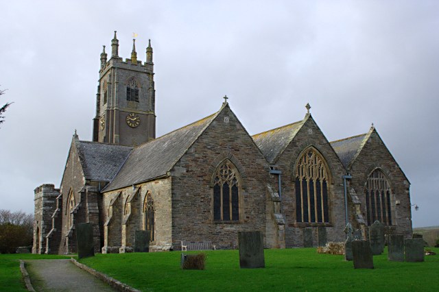
St. Columb Major is known for its historic church, St. Columba's Church, which dates back to the 14th century and is a Grade I listed building. The parish also has a number of other historic buildings and landmarks, including the Market Cross and the Town Hall.

The town is centered around a traditional market square, which hosts a weekly market and various events throughout the year. There are also a range of shops, pubs, and restaurants in the town, as well as a primary school and community facilities.

St. Columb Major is surrounded by beautiful countryside, with plenty of opportunities for outdoor activities such as walking, cycling, and horse riding. The parish is also well-connected by road, with easy access to the A30 and other major routes in Cornwall.

If you have any feedback on the listing, please let us know in the comments section below.

St. Columb Major Images

Images are sourced within 2km of 50.435732/-4.931345 or Grid Reference SW9163. Thanks to Geograph Open Source API. All images are credited.

St Columb Major, Bank St
Restormel : The A39 The A39 heads past St Columb Major here in the former Cornish district of Restormel.
Restormel : The A39
The A39 heads past St Columb Major here in the former Cornish district of Restormel.
Restormel : The A39 Traffic on the A39 as it bypasses the town of St Columb Major.
Restormel : The A39
Traffic on the A39 as it bypasses the town of St Columb Major.
Restormel : Country Lane A lane heads from here in St Columb Major and underneath the trees.
Restormel : Country Lane
A lane heads from here in St Columb Major and underneath the trees.
St Columb Major : Newquay Road Newquay Road in Columb Major taken from the junction at Trekenning Road.
St Columb Major : Newquay Road
Newquay Road in Columb Major taken from the junction at Trekenning Road.
St Columb Major : Fair Street Fair Street taken on the road junction with Newquay Road.
St Columb Major : Fair Street
Fair Street taken on the road junction with Newquay Road.
Junction for Quoit Farm and Ruthvoes
The minor road to Quoit Farm and Ruthvoes
Walhalla Farm
Walhalla Farm
Industrial and retail units on the south-west of St Columb Major Buildings on the north side of the A3059
Industrial and retail units on the south-west of St Columb Major
Buildings on the north side of the A3059
Milestone at Trekenning
A39 crossing a small stream The stream runs east-west just north of Rosewastis farm
A39 crossing a small stream
The stream runs east-west just north of Rosewastis farm
Bridge carrying minor road over A39 south of St Columb Major On the left there are industrial buildings on the edge of the village.
Bridge carrying minor road over A39 south of St Columb Major
On the left there are industrial buildings on the edge of the village.
A39 passing St Columb Major The road to the right is a minor one which leads to Hill Head and a caravan park
A39 passing St Columb Major
The road to the right is a minor one which leads to Hill Head and a caravan park
Footpath sign by the A39 Despite this being principally a through route for vehicles, there is sufficient pedestrian traffic to merit a pedestrian sign to the town centre.
Footpath sign by the A39
Despite this being principally a through route for vehicles, there is sufficient pedestrian traffic to merit a pedestrian sign to the town centre.
A39 junction for St Columb Major Although St Columb Major is to the left of the A39, the signs take traffic to the right using wider roads than the single track road to the left through Talskiddy.
A39 junction for St Columb Major
Although St Columb Major is to the left of the A39, the signs take traffic to the right using wider roads than the single track road to the left through Talskiddy.
A39 cutting west of Trevornick Farm The lane on the left is the slip road for traffic from St Eval which joined at a crossroads before the cutting.
A39 cutting west of Trevornick Farm
The lane on the left is the slip road for traffic from St Eval which joined at a crossroads before the cutting.
St Columb Major: junction of Fore Street and Union Hill
Show me another place!

St. Columb Major is located at Grid Ref: SW9163 (Lat: 50.435732, Lng: -4.931345)

Unitary Authority: Cornwall

Police Authority: Devon & Cornwall

What 3 Words

///whirlpool.promoting.evoke. Near St Columb Major, Cornwall

Related Wikis

St Columba's Church, St Columb Major

St Columba's Church is a 14th-century, Grade I listed parish church in the Church of England Diocese of Truro in St Columb Major, Cornwall. In 1860 plans...

St Columb Major

St Columb Major is a town and civil parish in Cornwall, England, United Kingdom. Often referred to locally as St Columb, it is approximately seven miles...

Tregatillian

Tregatillian is a hamlet immediately east of St. Columb Major in Cornwall, England, United Kingdom. The area is currently the site of a few traditional...

The Old Rectory, St Columb Major

The Old Rectory is a grade II* listed Victorian moated Rectory, located on the banks of the River Menalhyl in St Columb Major, in Cornwall, England. It...

Nearby Amenities

Located within 500m of 50.435732,-4.931345
Post Box
Collection Times: Mo-Fr 09:00; Sa 07:00; Su off
Operator: Royal Mail
Operator Wikidata: Q638098
Post Box Mounting: pier
Post Box Type: lamp
Ref: TR9 116D
Royal Cypher: EIIR
Royal Cypher Wikidata: Q33102113
Source: survey;aerial imagery
Lat/Long: 50.4347158/-4.9379129
Material: wood
Power: pole
Lat/Long: 50.4334818/-4.9358118
Material: wood
Power: pole
Lat/Long: 50.4328428/-4.9358171
Power: pole
Lat/Long: 50.4343506/-4.9286918
Power: pole
Lat/Long: 50.4335647/-4.9282533
Power: pole
Lat/Long: 50.4327608/-4.9277892
Power: pole
Lat/Long: 50.432045/-4.9288246
Power: pole
Lat/Long: 50.4328428/-4.9282493
Power: pole
Lat/Long: 50.4336689/-4.9274419
Power: pole
Lat/Long: 50.4342694/-4.9266279
Power: pole
Lat/Long: 50.4350007/-4.9251312
Power: pole
Lat/Long: 50.4316101/-4.928602
Power: pole
Lat/Long: 50.4322876/-4.9277115
Power: pole
Lat/Long: 50.4328599/-4.926876
Power: pole
Lat/Long: 50.4334357/-4.9261317
Power: pole
Lat/Long: 50.4342182/-4.9250212
Material: wood
Power: pole
Lat/Long: 50.4382295/-4.9323034
Power: pole
Lat/Long: 50.4380732/-4.9305385
Power: pole
Lat/Long: 50.4379314/-4.9288313
Power: pole
Lat/Long: 50.4379579/-4.9275814
Power: pole
Lat/Long: 50.4379895/-4.9268813
Generator Method: photovoltaic
Generator Output Electricity: yes
Generator Source: solar
Generator Type: solar_photovoltaic_panel
Location: roof
Power: generator
Lat/Long: 50.4365382/-4.9329311
Generator Method: photovoltaic
Generator Output Electricity: yes
Generator Source: solar
Generator Type: solar_photovoltaic_panel
Location: roof
Power: generator
Lat/Long: 50.435122/-4.9372843
Generator Method: photovoltaic
Generator Output Electricity: yes
Generator Source: solar
Generator Type: solar_photovoltaic_panel
Location: roof
Power: generator
Lat/Long: 50.4351314/-4.9372253
Generator Method: photovoltaic
Generator Output Electricity: yes
Generator Source: solar
Generator Type: solar_photovoltaic_panel
Location: roof
Power: generator
Lat/Long: 50.4344437/-4.9369651
Generator Method: photovoltaic
Generator Output Electricity: yes
Generator Source: solar
Generator Type: solar_photovoltaic_panel
Location: roof
Power: generator
Lat/Long: 50.4342874/-4.9368404
Generator Method: photovoltaic
Generator Output Electricity: yes
Generator Source: solar
Generator Type: solar_photovoltaic_panel
Location: roof
Power: generator
Lat/Long: 50.4342361/-4.9369128
Generator Method: photovoltaic
Generator Output Electricity: yes
Generator Source: solar
Generator Type: solar_photovoltaic_panel
Location: roof
Power: generator
Lat/Long: 50.4341037/-4.9377523
Generator Method: photovoltaic
Generator Output Electricity: yes
Generator Source: solar
Generator Type: solar_photovoltaic_panel
Location: roof
Power: generator
Lat/Long: 50.4338765/-4.9377389
Generator Method: photovoltaic
Generator Output Electricity: yes
Generator Source: solar
Generator Type: solar_photovoltaic_panel
Location: roof
Power: generator
Lat/Long: 50.4339021/-4.9377376
The data included in this document is from www.openstreetmap.org. The data is made available under ODbL.

Have you been to St. Columb Major?

Leave your review of St. Columb Major below (or comments, questions and feedback).