South Cadbury and Sutton Montis

Civil Parish in Somerset South Somerset

England

South Cadbury and Sutton Montis

Teals farm shop at South Cadbury This large farm shop includes a cafe, a deli and a butcher's. It even has its own cider orchard and beehives.
Teals farm shop at South Cadbury Credit: Rod Allday

South Cadbury and Sutton Montis are adjacent civil parishes located in the county of Somerset, England. South Cadbury is situated about 5 miles south-east of Yeovil, while Sutton Montis lies approximately 6 miles to the south of Yeovil. The two parishes are part of the South Somerset district.

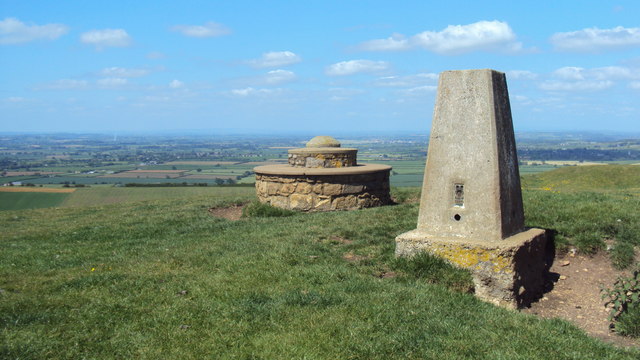
South Cadbury is perhaps best known for its association with the legendary King Arthur. The village is home to Cadbury Castle, an ancient hillfort believed by some to be the site of Camelot. The hillfort offers stunning panoramic views of the surrounding countryside and is a popular destination for hikers and history enthusiasts alike. The village itself features a mix of charming cottages and more modern houses, as well as a pub, a church, and a primary school.

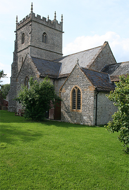
Sutton Montis, on the other hand, is a smaller and quieter parish with a population of approximately 200 residents. It is characterized by its picturesque countryside, rolling hills, and quaint stone houses. The village is home to the Church of All Saints, a Grade II listed building that dates back to the 15th century. The church is known for its beautiful stained glass windows and historic architecture.

Both South Cadbury and Sutton Montis offer a peaceful and rural lifestyle, with easy access to the larger towns of Yeovil and Sherborne. The surrounding countryside provides ample opportunities for outdoor activities such as walking, cycling, and horse riding. The parishes are also well-connected by road, making them convenient for commuters and visitors alike.

If you have any feedback on the listing, please let us know in the comments section below.

South Cadbury and Sutton Montis Images

Images are sourced within 2km of 51.024015/-2.534305 or Grid Reference ST6225. Thanks to Geograph Open Source API. All images are credited.

Teals farm shop at South Cadbury This large farm shop includes a cafe, a deli and a butcher's. It even has its own cider orchard and beehives.
Teals farm shop at South Cadbury
This large farm shop includes a cafe, a deli and a butcher's. It even has its own cider orchard and beehives.
The gable end of Teals farm shop at South Cadbury
St Mary Magdalene's Church, Sparkford, Somerset
Church of the Holy Cross, Weston Bampfylde, Somerset
The Beacon Trigpoint and stone seat on Corton Hill. In the distance is a view across the Somerset Levels.
The Beacon
Trigpoint and stone seat on Corton Hill. In the distance is a view across the Somerset Levels.
South Cadbury: towards Cadbury Castle The lane linking South Cadbury and Corton Denham
South Cadbury: towards Cadbury Castle
The lane linking South Cadbury and Corton Denham
South Cadbury: towards Parrock Hill On the lane linking South Cadbury and Corton Denham. Now part of the Monarch's way. But the route is unconvincing here as it goes nowhere near Trent, where Charles II holed up for a week after defeat at the Battle of Worcester, before escaping to Fecamp
South Cadbury: towards Parrock Hill
On the lane linking South Cadbury and Corton Denham. Now part of the Monarch's way. But the route is unconvincing here as it goes nowhere near Trent, where Charles II holed up for a week after defeat at the Battle of Worcester, before escaping to Fecamp
A303, eastbound The A303 is a main trunk road running 92 miles between Basingstoke and Honiton. Along with the A30 and M3 it forms a major route between London and the South West. Much of the road is dual carriageway, but some stretches remain single and prone to congestion.

Wikipedia: <span class="nowrap"><a title="http://en.wikipedia.org/wiki/A303_road" rel="nofollow ugc noopener" href="http://en.wikipedia.org/wiki/A303_road">Link</a><img style="margin-left:2px;" alt="External link" title="External link - shift click to open in new window" src="https://s1.geograph.org.uk/img/external.png" width="10" height="10"/></span>
A303, eastbound
The A303 is a main trunk road running 92 miles between Basingstoke and Honiton. Along with the A30 and M3 it forms a major route between London and the South West. Much of the road is dual carriageway, but some stretches remain single and prone to congestion. Wikipedia: LinkExternal link
Show me another place!

South Cadbury and Sutton Montis is located at Grid Ref: ST6225 (Lat: 51.024015, Lng: -2.534305)

Administrative County: Somerset

District: South Somerset

Police Authority: Avon and Somerset

What 3 Words

///bypasses.careless.tribe. Near Castle Cary, Somerset

Related Wikis

Cadbury Castle, Somerset

Cadbury Castle is a Bronze and Iron Age hillfort in the civil parish of South Cadbury in the English county of Somerset. It is a scheduled monument and...

Church of the Holy Trinity, Sutton Montis

The Anglican Church of the Holy Trinity at Sutton Montis in the parish of South Cadbury and Sutton Montis, Somerset, England, has Saxon origins but most...

Church of St Thomas à Becket, South Cadbury

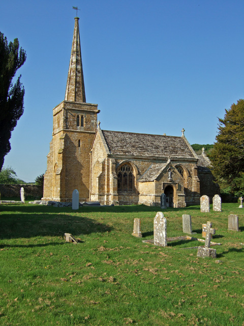
The Church of St Thomas à Becket is the Anglican parish church for the ancient village of South Cadbury in Somerset and is dedicated to Thomas Becket....

South Cadbury

South Cadbury is a village and former civil parish, now in the parish of South Cadbury and Sutton Montis, in the Somerset district of the ceremonial county...

Church of the Holy Cross, Weston Bampfylde

The Anglican Church of the Holy Cross in Weston Bampfylde, Sparkford, Somerset, England, was built in the 13th century. It is a Grade II* listed building...

Church of St Mary Magdalene, Sparkford

The Anglican Church of St Mary Magdalene in Sparkford, Somerset, England was built in the 14th century. It is a Grade II* listed building. == History... ==

RNAS Charlton Horethorne (HMS Heron II)

Royal Naval Air Station Charlton Horethorne, (RNAS Charlton Horethorne; or HMS Heron II) is a former Royal Naval Air Station in the hamlet of Sigwells...

Church of St Mary, Compton Pauncefoot

The Anglican Church of St Mary in Compton Pauncefoot, Somerset, England was built in the 15th century. It is a Grade II* listed building. == History... ==

Nearby Amenities

Located within 500m of 51.024015,-2.534305
Sutton Montis
Place: village
Source: npe
Wikidata: Q22964089
Lat/Long: 51.019884/-2.5359872
Power: pole
Lat/Long: 51.0279575/-2.5342797
Power: pole
Lat/Long: 51.0272733/-2.535963
Power: pole
Lat/Long: 51.0266043/-2.537519
Power: pole
Lat/Long: 51.0259093/-2.5392333
Power: pole
Lat/Long: 51.0252013/-2.5409717
Addr City: Sutton Montis
Addr Housename: Village End
Addr Street: Church Hill
Description: House
Lat/Long: 51.0225141/-2.5382606
Addr City: Sutton Montis
Addr Housename: Church Cottage
Addr Street: Church Hill
Lat/Long: 51.0207814/-2.5364934
Post Box
Operator: Royal Mail
Operator Wikidata: Q638098
Post Box Type: wall
Ref: BA22 75
Royal Cypher: EIIR
Royal Cypher Wikidata: Q33102113
Lat/Long: 51.0199085/-2.536657
Ele: 155
Natural: peak
Lat/Long: 51.0241829/-2.5313315
The data included in this document is from www.openstreetmap.org. The data is made available under ODbL.

Have you been to South Cadbury and Sutton Montis?

Leave your review of South Cadbury and Sutton Montis below (or comments, questions and feedback).