Sourton

Civil Parish in Devon West Devon

England

Sourton

Walkers on Sourton Tors There's a trig point up there somewhere.
Walkers on Sourton Tors Credit: John Lucas

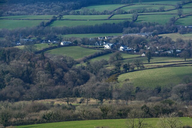
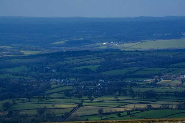
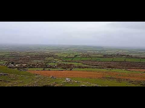
Sourton is a civil parish located in Devon, England. It is situated on the western edge of Dartmoor National Park, offering stunning views of the surrounding countryside. The parish includes the small village of Sourton, which has a population of around 300 residents.

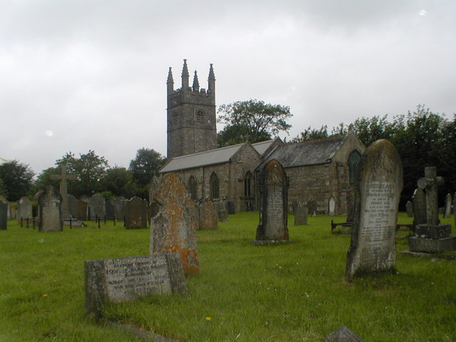
Sourton is known for its historic charm, with many traditional thatched cottages and old stone buildings lining the streets. The parish is also home to the famous Sourton Tors, a series of rocky outcrops that provide a popular spot for hiking and rock climbing.

In addition to its natural beauty, Sourton has a strong sense of community, with a local pub, village hall, and primary school serving as gathering places for residents. The parish is also well-connected, with easy access to the A30 and A386 roads, making it a convenient location for commuters and visitors alike.

Overall, Sourton is a picturesque and welcoming parish that offers a peaceful and idyllic setting for those looking to enjoy the beauty of the Devon countryside.

If you have any feedback on the listing, please let us know in the comments section below.

Sourton Images

Images are sourced within 2km of 50.686525/-4.088365 or Grid Reference SX5289. Thanks to Geograph Open Source API. All images are credited.

Walkers on Sourton Tors There's a trig point up there somewhere.
Walkers on Sourton Tors
There's a trig point up there somewhere.
Dartmoor : Countryside Scenery Looking across the countryside.
Dartmoor : Countryside Scenery
Looking across the countryside.
Dartmoor : Countryside Scenery Looking across the countryside.
Dartmoor : Countryside Scenery
Looking across the countryside.
Dartmoor : Countryside Scenery Looking out across the countryside.
Dartmoor : Countryside Scenery
Looking out across the countryside.
Dartmoor : Moorland Scenery Looking out across the moors and beyond.
Dartmoor : Moorland Scenery
Looking out across the moors and beyond.
Dartmoor : Countryside Scenery Looking out across the countryside.
Dartmoor : Countryside Scenery
Looking out across the countryside.
Dartmoor : Bridestowe Scenery Looking towards the village of Bridestowe.
Dartmoor : Bridestowe Scenery
Looking towards the village of Bridestowe.
Early Christian Inscribed Stone at Sourton <span class="nowrap"><a title="https://historicengland.org.uk/listing/the-list/list-entry/1165845?section=official-list-entry" rel="nofollow ugc noopener" href="https://historicengland.org.uk/listing/the-list/list-entry/1165845?section=official-list-entry">Link</a><img style="margin-left:2px;" alt="External link" title="External link - shift click to open in new window" src="https://s1.geograph.org.uk/img/external.png" width="10" height="10"/></span>
Early Christian Inscribed Stone at Sourton
Shortacombe : The A386 Looking along the A386.
Shortacombe : The A386
Looking along the A386.
Shortacombe : The A386 Looking along the A386.
Shortacombe : The A386
Looking along the A386.
Lake : The A386 Looking along the A386.
Lake : The A386
Looking along the A386.
Lake : The A386 Looking along the A386.
Lake : The A386
Looking along the A386.
Lake : The A386 Entering the hamlet of Lake.
Lake : The A386
Entering the hamlet of Lake.
Lake : The A386 The A386 enters the hamlet of Lake.
Lake : The A386
The A386 enters the hamlet of Lake.
Sourton : The A386 Looking along the A386.
Sourton : The A386
Looking along the A386.
Sourton : The A386 Looking along the A386.
Sourton : The A386
Looking along the A386.
Sourton : The Highwayman Inn Quoted as being ‘the most unusual pub in Britain,’.
Sourton : The Highwayman Inn
Quoted as being ‘the most unusual pub in Britain,’.
Sourton : The A386 Looking along the A386.
Sourton : The A386
Looking along the A386.
Show me another place!

Sourton is located at Grid Ref: SX5289 (Lat: 50.686525, Lng: -4.088365)

Administrative County: Devon

District: West Devon

Police Authority: Devon & Cornwall

What 3 Words

///desktop.lends.boasted. Near Okehampton, Devon

Nearby Locations

Sourton

Related Wikis

Bridestowe

Bridestowe () is a civil parish and village in the district of West Devon, Devon, England. The parish is surrounded clockwise from the north by the parishes...

Sourton

Sourton is a small village and civil parish in West Devon, England. It lies about 4 miles (6.4 km) south-west of Okehampton. It is at the north-western...

St Bridget's Church, Bridestowe

St Bridget's Church in Bridestowe, Devon, is a parish church in the Church of England and one of the central buildings in the rural area on the northwestern...

Bridestowe railway station

Bridestowe railway station served the 2 miles or so distant village of Bridestowe in West Devon, England, located outside Okehampton on the edge of Dartmoor...

Related Videos

Two Days Away ( Dartmoor and Cotehele House

A short 2 day break on the edge of Dartmoor visiting Widgery Cross , Tavistock and Cotehele house.

The highwayman Inn

A look inside one of the rooms at the Highwayman Inn at Sourton, near Okehampton, Devon, England.

episode 3.....Sourton Tor, Shelstone Tor and Meldon.

a nice walk starting at Sourton, going over Sourton Tor, Shelstone Tor and Meldon reservoir, all was well apart from those pesky ...

Nearby Amenities

Located within 500m of 50.686525,-4.088365
Give Way
Lat/Long: 50.6831642/-4.0843613
Brand: National Grid
Brand Wikidata: Q1465461
Location Transition: yes
Material: wood
Operator: National Grid Electricity Distribution Plc
Operator Old: Western Power Distribution
Operator Wikidata: Q7988183
Owner: National Grid Electricity Distribution (South West) Plc
Owner Wikidata: Q114397866
Power: pole
Lat/Long: 50.6857766/-4.0836766
Brand: National Grid
Brand Wikidata: Q1465461
Material: wood
Operator: National Grid Electricity Distribution Plc
Operator Old: Western Power Distribution
Operator Wikidata: Q7988183
Owner: National Grid Electricity Distribution (South West) Plc
Owner Wikidata: Q114397866
Power: pole
Lat/Long: 50.6859703/-4.0840763
Brand: National Grid
Brand Wikidata: Q1465461
Material: wood
Operator: National Grid Electricity Distribution Plc
Operator Old: Western Power Distribution
Operator Wikidata: Q7988183
Owner: National Grid Electricity Distribution (South West) Plc
Owner Wikidata: Q114397866
Power: pole
Lat/Long: 50.6861487/-4.0844598
Brand: National Grid
Brand Wikidata: Q1465461
Material: wood
Operator: National Grid Electricity Distribution Plc
Operator Old: Western Power Distribution
Operator Wikidata: Q7988183
Owner: National Grid Electricity Distribution (South West) Plc
Owner Wikidata: Q114397866
Power: pole
Lat/Long: 50.6826666/-4.0871877
Brand: National Grid
Brand Wikidata: Q1465461
Material: wood
Operator: National Grid Electricity Distribution Plc
Operator Old: Western Power Distribution
Operator Wikidata: Q7988183
Owner: National Grid Electricity Distribution (South West) Plc
Owner Wikidata: Q114397866
Power: pole
Lat/Long: 50.6833974/-4.0869811
Brand: National Grid
Brand Wikidata: Q1465461
Material: wood
Operator: National Grid Electricity Distribution Plc
Operator Old: Western Power Distribution
Operator Wikidata: Q7988183
Owner: National Grid Electricity Distribution (South West) Plc
Owner Wikidata: Q114397866
Power: pole
Lat/Long: 50.6843474/-4.0866807
Brand: National Grid
Brand Wikidata: Q1465461
Material: wood
Operator: National Grid Electricity Distribution Plc
Operator Old: Western Power Distribution
Operator Wikidata: Q7988183
Owner: National Grid Electricity Distribution (South West) Plc
Owner Wikidata: Q114397866
Power: pole
Lat/Long: 50.6850255/-4.0861201
Brand: National Grid
Brand Wikidata: Q1465461
Material: wood
Operator: National Grid Electricity Distribution Plc
Operator Old: Western Power Distribution
Operator Wikidata: Q7988183
Owner: National Grid Electricity Distribution (South West) Plc
Owner Wikidata: Q114397866
Power: pole
Lat/Long: 50.6856746/-4.085522
Brand: National Grid
Brand Wikidata: Q1465461
Material: wood
Operator: National Grid Electricity Distribution Plc
Operator Old: Western Power Distribution
Operator Wikidata: Q7988183
Owner: National Grid Electricity Distribution (South West) Plc
Owner Wikidata: Q114397866
Power: pole
Lat/Long: 50.6863765/-4.0848917
Brand: National Grid
Brand Wikidata: Q1465461
Material: wood
Operator: National Grid Electricity Distribution Plc
Operator Old: Western Power Distribution
Operator Wikidata: Q7988183
Owner: National Grid Electricity Distribution (South West) Plc
Owner Wikidata: Q114397866
Power: pole
Lat/Long: 50.6870511/-4.084264
Brand: National Grid
Brand Wikidata: Q1465461
Material: wood
Operator: National Grid Electricity Distribution Plc
Operator Old: Western Power Distribution
Operator Wikidata: Q7988183
Owner: National Grid Electricity Distribution (South West) Plc
Owner Wikidata: Q114397866
Power: pole
Lat/Long: 50.6877053/-4.083682
Brand: National Grid
Brand Wikidata: Q1465461
Material: wood
Operator: National Grid Electricity Distribution Plc
Operator Old: Western Power Distribution
Operator Wikidata: Q7988183
Owner: National Grid Electricity Distribution (South West) Plc
Owner Wikidata: Q114397866
Power: pole
Lat/Long: 50.6885023/-4.0829954
The data included in this document is from www.openstreetmap.org. The data is made available under ODbL.

Have you been to Sourton?

Leave your review of Sourton below (or comments, questions and feedback).