Smallburgh

Civil Parish in Norfolk North Norfolk

England

Smallburgh

On Tylers Cut Approaching a junction to the southeast of Dilham.
On Tylers Cut Credit: Martin Addison

Smallburgh is a civil parish located in the county of Norfolk, England. Situated approximately 11 miles northeast of the city of Norwich, it covers an area of about 6.5 square miles. The parish is surrounded by the parishes of Scottow, Dilham, Worstead, and Swanton Abbott.

The village of Smallburgh itself is home to a population of around 700 residents. It is a small, rural community with a charming and picturesque atmosphere. The village has a rich history, with evidence of human habitation dating back to the Bronze Age. The area has seen various archaeological finds, including Roman pottery and a Roman coin hoard.

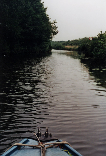
Smallburgh is known for its beautiful countryside, characterized by rolling fields, meadows, and woodlands. The parish is crisscrossed by several footpaths and bridleways, providing ample opportunities for outdoor activities and exploring the scenic surroundings.

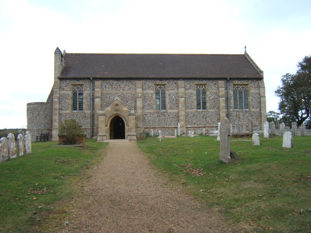
The village is served by St. Peter's Church, a Grade I listed building that dates back to the 13th century. The church is known for its impressive architecture and houses several notable features, including a medieval font and stained glass windows.

Smallburgh is a close-knit community with a range of amenities and facilities to cater to its residents. These include a primary school, a village hall, a pub, and a small convenience store. The village also hosts various events and activities throughout the year, fostering a strong sense of community spirit.

In conclusion, Smallburgh is a picturesque and historic civil parish in Norfolk, offering a peaceful rural lifestyle and a strong sense of community.

If you have any feedback on the listing, please let us know in the comments section below.

Smallburgh Images

Images are sourced within 2km of 52.767955/1.458313 or Grid Reference TG3324. Thanks to Geograph Open Source API. All images are credited.

On Tylers Cut Approaching a junction to the southeast of Dilham.
On Tylers Cut
Approaching a junction to the southeast of Dilham.
On Tylers Cut The Skipper keeps a weather eye for'rard whilst the Helmsman steers his course sou' by east from Dilham.

Taken on a trip with a retired work colleague from Dilham Staithe to Stalham.
On Tylers Cut
The Skipper keeps a weather eye for'rard whilst the Helmsman steers his course sou' by east from Dilham. Taken on a trip with a retired work colleague from Dilham Staithe to Stalham.
The Church of St Nicholas, Dilham A very welcoming little church, some distance from Dilham village.
The Church of St Nicholas, Dilham
A very welcoming little church, some distance from Dilham village.
Dilham Cross Keys, Jan 2014 "A stunning 56 pubs close every month - usually demolished or converted into housing.  Country pubs are disappearing the fastest.  More than half the villages of England are now 'dry' for the first time since the Norman Conquest." Mail Online 27-01-14
Dilham Cross Keys, Jan 2014
"A stunning 56 pubs close every month - usually demolished or converted into housing. Country pubs are disappearing the fastest. More than half the villages of England are now 'dry' for the first time since the Norman Conquest." Mail Online 27-01-14
St Nicholas, Dilham
St Nicholas, Dilham
St Nicholas, Dilham - Grave
St Nicholas, Dilham
St Nicholas, Dilham
St Nicholas, Dilham - War Memorial WWI & WWII
St Nicholas, Dilham - War Memorial WWI
St Nicholas, Dilham - War Memorial WWII
St Nicholas, Dilham - Stained glass window
St Nicholas, Dilham - Royal Arms
St Nicholas, Dilham - East end
St Nicholas, Dilham - Banner
St Nicholas, Dilham - Roof angel
The truncated tower of Dilham church The round tower, which was originally embattled, was rebuilt in the mid-1820s using materials from the earlier one which had partially collapsed. Then in 1831, the whole church was rebuilt but the top of the tower was demolished and a baptistery created beneath what was the belfry floor leaving the church resembling a barn rather than a church.
The truncated tower of Dilham church
The round tower, which was originally embattled, was rebuilt in the mid-1820s using materials from the earlier one which had partially collapsed. Then in 1831, the whole church was rebuilt but the top of the tower was demolished and a baptistery created beneath what was the belfry floor leaving the church resembling a barn rather than a church.
Show me another place!

Smallburgh is located at Grid Ref: TG3324 (Lat: 52.767955, Lng: 1.458313)

Administrative County: Norfolk

District: North Norfolk

Police Authority: Norfolk

What 3 Words

///sulky.after.plodding. Near Stalham, Norfolk

Nearby Locations

Smallburgh

Related Wikis

Dilham

Dilham is a village and civil parish in the English county of Norfolk. The village is located 4.3 miles south-east of North Walsham and 12 miles north...
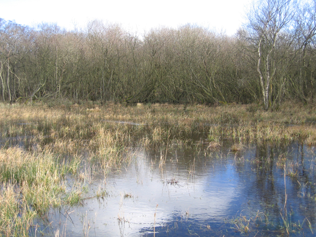
Smallburgh Fen

Smallburgh Fen is a 7.6-hectare (19-acre) biological Site of Special Scientific Interest in Smallburgh in Norfolk, United Kingdom It is part of the Broadland...

Smallburgh

Smallburgh is a village and a civil parish in the English county of Norfolk. The village is fourteen miles (21 km) south-east of Cromer, fourteen miles...

Broad Fen, Dilham

Broad Fen, Dilham is a 38.4-hectare (95-acre) biological Site of Special Scientific Interest north-east of Norwich in Norfolk. It is part of the Broadland...

Nearby Amenities

Located within 500m of 52.767955,1.458313
Hillfield, adj
Naptan AtcoCode: 2900S272
Naptan Bearing: SW
Naptan BusStopType: CUS
Naptan CommonName: Hillfield
Naptan Indicator: adj
Naptan Landmark: Hillfield
Naptan Locality: Smallburgh
Naptan NaptanCode: nfodtjmd
Naptan Street: Union Road
Naptan Verified: no
Source: naptan_import
Lat/Long: 52.7677852/1.4526282
Bus Stop
Crown, adj
Naptan AtcoCode: 2900S274
Naptan Bearing: SE
Naptan CommonName: Crown
Naptan Indicator: adj
Naptan Landmark: public house
Naptan Locality: Smallburgh
Naptan NaptanCode: nfodtjmg
Naptan Street: Yarmouth Road
Naptan Verified: no
Source: naptan_import
Lat/Long: 52.768124/1.4545828
Crown, opp
Naptan AtcoCode: 2900S279
Naptan Bearing: NW
Naptan BusStopType: CUS
Naptan CommonName: Crown
Naptan Indicator: opp
Naptan Landmark: public house
Naptan Locality: Smallburgh
Naptan NaptanCode: nfodtjmw
Naptan Street: Yarmouth Road
Naptan Verified: no
Source: naptan_import
Lat/Long: 52.7679881/1.4546165
Bus Stop
The Street, adj
Naptan AtcoCode: 2900S80
Naptan Bearing: SE
Naptan CommonName: The Street
Naptan Indicator: adj
Naptan Locality: Dilham
Naptan NaptanCode: nfogmptg
Naptan Street: Yarmouth Road
Naptan Verified: no
Source: naptan_import
Lat/Long: 52.7704887/1.4530648
Smallburgh
Place: village
Source: bing
Lat/Long: 52.7680917/1.4538416
Post Box
Lat/Long: 52.7679554/1.4546987
Crossing
Crossing: unmarked
Lat/Long: 52.7676851/1.452592
Crossing
Crossing: unmarked
Lat/Long: 52.7673663/1.4528212
Barrier: block
Lat/Long: 52.7640738/1.4617168
Barrier: block
Lat/Long: 52.7643833/1.4586179
Smallburgh
Colour: grey
Inscription: 2000 / This sign was unveiled on 13th October 2001.It was designed by Mr.John Green and made and donated to the village by Mr.Paul Ward
Man Made: village_sign
Material: metal
Lat/Long: 52.7661998/1.4563191
Give Way
Lat/Long: 52.7678028/1.4548845
Give Way
Lat/Long: 52.7677529/1.4524966
The data included in this document is from www.openstreetmap.org. The data is made available under ODbL.

Have you been to Smallburgh?

Leave your review of Smallburgh below (or comments, questions and feedback).