Rollright

Civil Parish in Oxfordshire West Oxfordshire

England

Rollright

Slurry injection This grass field has been fertilised by the injection of liquid slurry in specially created slits.
Slurry injection Credit: Marion Phillips

Rollright is a civil parish located in the county of Oxfordshire, England. Situated about 4 miles north-west of Chipping Norton, it covers an area of approximately 5 square miles. The parish is comprised of three distinct settlements: Little Rollright, Great Rollright, and the Rollright Stones.

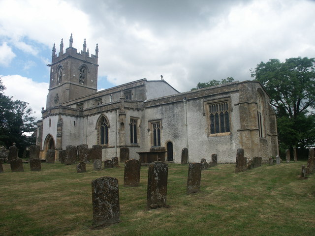
Great Rollright is the largest of the three settlements and is home to the majority of the parish's population. It consists of a mix of residential houses, farms, and small businesses. The village is characterized by its charming stone cottages and picturesque countryside views.

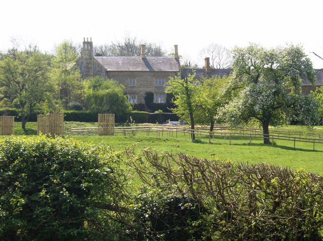
Little Rollright is a smaller hamlet located to the west of Great Rollright, comprising mainly of agricultural land and a few scattered residences.

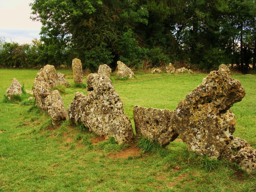
The Rollright Stones, situated on the border of Warwickshire and Oxfordshire, are a famous historical and archaeological site within the parish. This ancient stone circle dates back to the Neolithic and Bronze Ages and is considered a nationally important heritage site. The circle consists of three main elements: the King's Men stone circle, the Whispering Knights burial chamber, and the King Stone. These prehistoric monuments attract visitors from near and far, intrigued by their mysterious origins and folklore.

Rollright is a rural parish with a strong sense of community. It offers a peaceful and idyllic countryside setting, making it an attractive place to live for those seeking a quieter lifestyle.

If you have any feedback on the listing, please let us know in the comments section below.

Rollright Images

Images are sourced within 2km of 51.978112/-1.540767 or Grid Reference SP3131. Thanks to Geograph Open Source API. All images are credited.

Slurry injection This grass field has been fertilised by the injection of liquid slurry in specially created slits.
Slurry injection
This grass field has been fertilised by the injection of liquid slurry in specially created slits.
Farmland near Rollright Stones Looking ESE across the farmland adjacent to the Rollright Stones.
Farmland near Rollright Stones
Looking ESE across the farmland adjacent to the Rollright Stones.
The Whispering Knights Dolmen of a Neolithic long barrow c3000 BC part of The Rollright Stones site <span class="nowrap"><a title="http://www.rollrightstones.co.uk/index.php/stones/" rel="nofollow ugc noopener" href="http://www.rollrightstones.co.uk/index.php/stones/">Link</a><img style="margin-left:2px;" alt="External link" title="External link - shift click to open in new window" src="https://s1.geograph.org.uk/img/external.png" width="10" height="10"/></span> the five stones lean inwards as if whispering to each other
The Whispering Knights
Dolmen of a Neolithic long barrow c3000 BC part of The Rollright Stones site LinkExternal link the five stones lean inwards as if whispering to each other
The Whispering Knights, Rollright Stones Who knows what secrets they are telling each other?
The Whispering Knights, Rollright Stones
Who knows what secrets they are telling each other?
Fertilizing the land, near Long Compton An almost pristine tractor and drill combination are injecting fertilizer into the soil ready for seed drilling. The tractor is an American Case IH unit and the drill is a British Weaving attachment. Together they are worth a substantial six figure sum and represent a significant investment on the part of the owner. In the background the A3400 road can be seen climbing a hill.
Fertilizing the land, near Long Compton
An almost pristine tractor and drill combination are injecting fertilizer into the soil ready for seed drilling. The tractor is an American Case IH unit and the drill is a British Weaving attachment. Together they are worth a substantial six figure sum and represent a significant investment on the part of the owner. In the background the A3400 road can be seen climbing a hill.
Fertilizing the land, near Long Compton Another view of the farming equipment seen here <a href="https://www.geograph.org.uk/photo/6969738">SP2930 : Fertilizing the land, near Long Compton</a>
Fertilizing the land, near Long Compton
Another view of the farming equipment seen here SP2930 : Fertilizing the land, near Long Compton
Path to Whispering Knights Running parallel to the ridgetop road past the Rollright Stones.
Path to Whispering Knights
Running parallel to the ridgetop road past the Rollright Stones.
Path to Whispering Knights Further along the path shown in <a href="https://www.geograph.org.uk/photo/7403990">SP2930 : Path to Whispering Knights</a>.
Path to Whispering Knights
Further along the path shown in SP2930 : Path to Whispering Knights.
Gate onto road near Whispering Knights Here the path shown in <a href="https://www.geograph.org.uk/photo/7404093">SP2930 : Path to Whispering Knights</a> turns away from the road behind the camera to run beside Brighthill Wood to the Whispering Knights dolmen. Across the road is the entrance to King Stone Farm.
Gate onto road near Whispering Knights
Here the path shown in SP2930 : Path to Whispering Knights turns away from the road behind the camera to run beside Brighthill Wood to the Whispering Knights dolmen. Across the road is the entrance to King Stone Farm.
Brighthill Wood near Whispering Knights From the path from the Kings Men circle.
Brighthill Wood near Whispering Knights
From the path from the Kings Men circle.
The Whispering Knights "The Whispering Knights portal dolmen is the easternmost example of its class with the majority of similar monuments being located in Cornwall, Wales and Ireland with only a small group in the east Cotswolds ... A free standing portal dolmen ... 357m east of the stone circle, ... four large upright oolite orthostats with a fallen capstone leaning at an angle to them. Together they enclose a chamber roughly 2m square which would originally have had a stone rubble cairn" <span class="nowrap"><a title="https://historicengland.org.uk/listing/the-list/list-entry/1018400?section=official-list-entry" rel="nofollow ugc noopener" href="https://historicengland.org.uk/listing/the-list/list-entry/1018400?section=official-list-entry">Link</a><img style="margin-left:2px;" alt="External link" title="External link - shift click to open in new window" src="https://s1.geograph.org.uk/img/external.png" width="10" height="10"/></span> .
The Whispering Knights
"The Whispering Knights portal dolmen is the easternmost example of its class with the majority of similar monuments being located in Cornwall, Wales and Ireland with only a small group in the east Cotswolds ... A free standing portal dolmen ... 357m east of the stone circle, ... four large upright oolite orthostats with a fallen capstone leaning at an angle to them. Together they enclose a chamber roughly 2m square which would originally have had a stone rubble cairn" LinkExternal link .
Seat by Whispering Knights This is referred to and explained at <a href="https://www.geograph.org.uk/photo/4712039">SP2930 : Ore stabit fortis arare placet ore stat</a> so I shan't provide a spoiler.
Seat by Whispering Knights
This is referred to and explained at SP2930 : Ore stabit fortis arare placet ore stat so I shan't provide a spoiler.
Great Rollright Church
The D'Arcy Dalton Way Heading for Great Rollright, here the D'Arcy Dalton Way <span class="nowrap"><a title="http://www.ramblers.org.uk/info/paths/darcydalton.html" rel="nofollow ugc noopener" href="http://www.ramblers.org.uk/info/paths/darcydalton.html">Link</a><img style="margin-left:2px;" alt="External link" title="External link - shift click to open in new window" src="https://s1.geograph.org.uk/img/external.png" width="10" height="10"/></span> follows the margin between the two fields of wheat, possibly this margin used to be a hedgerow.
The D'Arcy Dalton Way
Heading for Great Rollright, here the D'Arcy Dalton Way LinkExternal link follows the margin between the two fields of wheat, possibly this margin used to be a hedgerow.
Track and footpath, Great Rollright Footpath and track off the road to the west of Great Rollright. This footpath is followed by the D'Arcy Dalton Way.
Track and footpath, Great Rollright
Footpath and track off the road to the west of Great Rollright. This footpath is followed by the D'Arcy Dalton Way.
Show me another place!

Rollright is located at Grid Ref: SP3131 (Lat: 51.978112, Lng: -1.540767)

Administrative County: Oxfordshire

District: West Oxfordshire

Police Authority: Thames Valley

What 3 Words

///bloomers.slows.skirting. Near Chipping Norton, Oxfordshire

Nearby Locations

Rollright

Related Wikis

Rollright

Rollright is a civil parish in West Oxfordshire, England. It contains the villages of Great Rollright and Little Rollright and some of the prehistoric...

Great Rollright

Great Rollright is a village and former civil parish, now in the parish of Rollright, in the West Oxfordshire district, in Oxfordshire, England, and about...

Rollright Halt railway station

Rollright Halt railway station served the village of Great Rollright in Oxfordshire, England. == History == The station was built by the Great Western...

Rollright Stones

The Rollright Stones are a complex of three Neolithic and Bronze Age megalithic monuments near the village of Long Compton, on the borders of Oxfordshire...

Over Norton Park

Over Norton Park is a farm of 210 acres (85 ha) at Over Norton, lying to the north of Chipping Norton, in the Cotswolds, Oxfordshire, England. It has been...

Ascott, Warwickshire

Ascott is a village in Warwickshire, England. Population details can be found under Whichford. == External links == Media related to Ascott, Warwickshire...

Little Rollright

Little Rollright is a hamlet and former civil parish, now in the parish of Rollright, in the West Oxfordshire district, in the county of Oxfordshire, England...

Over Norton

Over Norton is a village and civil parish within the West Oxfordshire district, about 1 mile (2 km) north of Chipping Norton, Oxfordshire, England. Over...

Nearby Amenities

Located within 500m of 51.978112,-1.540767
Barrier: kissing_gate
Lat/Long: 51.9814122/-1.539024
The data included in this document is from www.openstreetmap.org. The data is made available under ODbL.

Have you been to Rollright?

Leave your review of Rollright below (or comments, questions and feedback).