Brundon

Settlement in Essex Babergh

England

Brundon

Middleton Road, Ballington At the junction with Lark Rise
Road No.C131
Middleton Road, Ballington Credit: Geographer

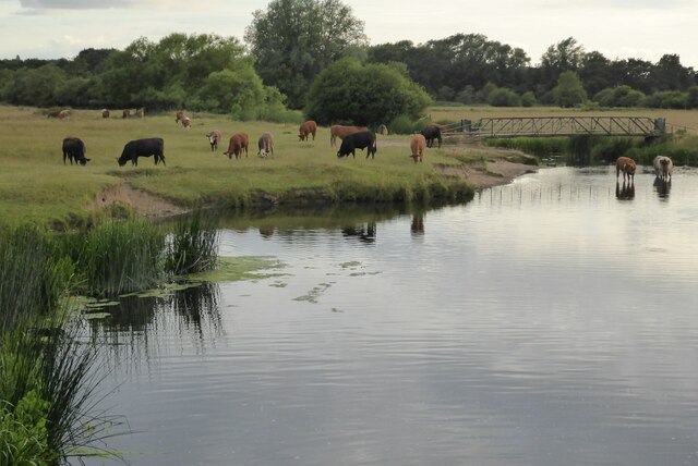
Brundon is a small village located in the county of Essex, England. Situated approximately 1.5 miles southeast of the market town of Sudbury, Brundon boasts a population of around 200 residents. The village is nestled on the banks of the River Stour, offering picturesque views of the surrounding countryside.

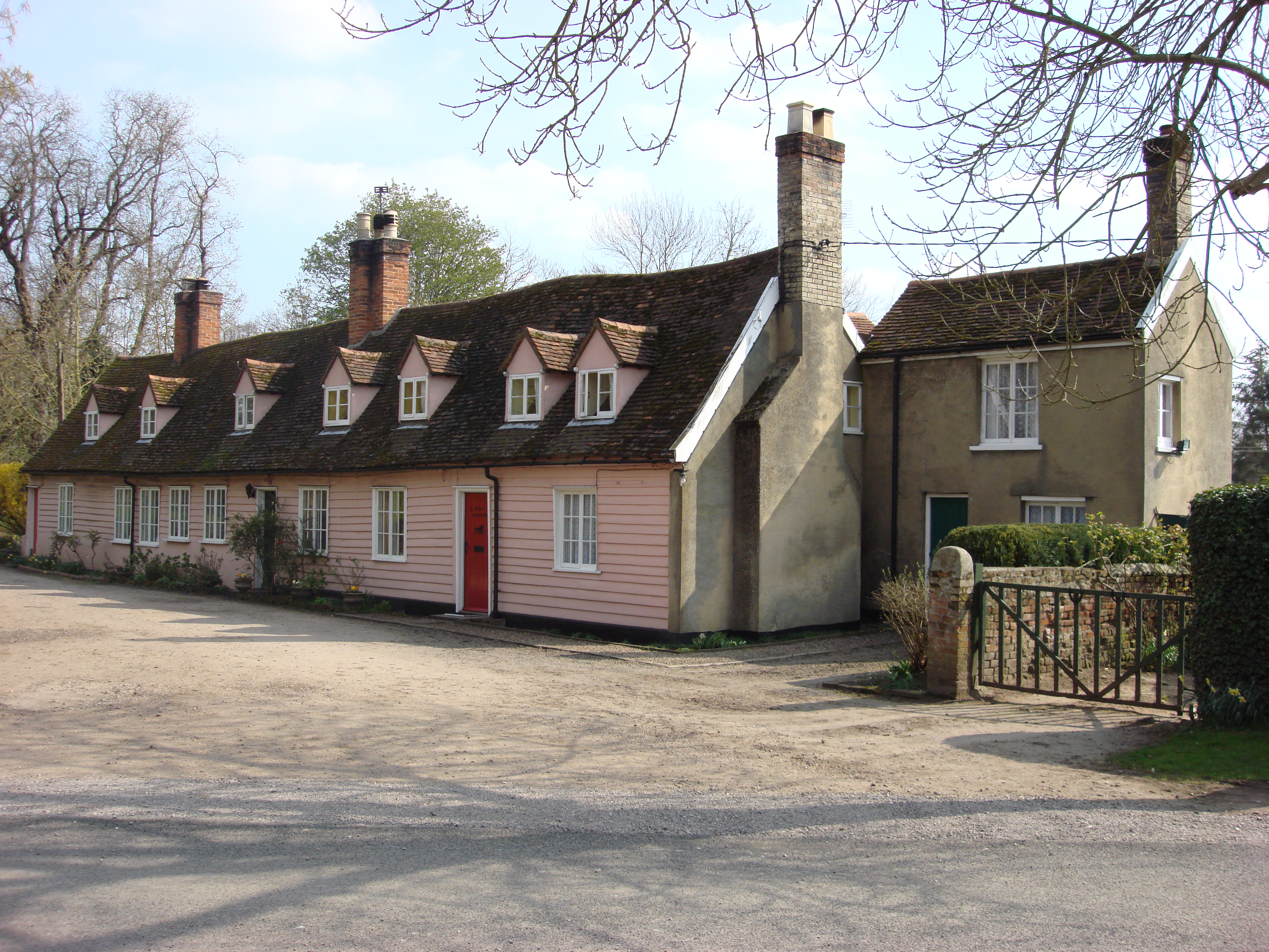
Brundon is known for its tranquil and idyllic setting, attracting visitors seeking a peaceful retreat away from the hustle and bustle of city life. The village is characterized by a mix of traditional and modern architecture, with charming cottages and modern houses dotted along its streets.

Despite its small size, Brundon offers a range of amenities for its residents and visitors. The village has a local pub, The Brundon Lion, which is a popular gathering spot for locals and visitors alike. Additionally, there is a village hall that serves as a community center, hosting various events and activities throughout the year.

Nature lovers are drawn to Brundon due to its proximity to the Stour Valley, a designated Area of Outstanding Natural Beauty. The surrounding countryside provides ample opportunity for outdoor pursuits such as hiking, cycling, and birdwatching. The river also offers opportunities for boating and fishing.

Overall, Brundon offers a charming and peaceful escape for those seeking a rural retreat. Its beautiful location, community spirit, and access to nature make it an attractive destination for both residents and visitors looking to unwind and enjoy the tranquility of the English countryside.

If you have any feedback on the listing, please let us know in the comments section below.

Brundon Images

Images are sourced within 2km of 52.047051/0.717578 or Grid Reference TL8642. Thanks to Geograph Open Source API. All images are credited.

Middleton Road, Ballington At the junction with Lark Rise
Road No.C131
Middleton Road, Ballington
At the junction with Lark Rise Road No.C131
Middleton Road, Ballington At the junction with the A131 Ballington Hill & A131 Ballington Street
Road No.C131
Middleton Road, Ballington
At the junction with the A131 Ballington Hill & A131 Ballington Street Road No.C131
Meadow View Road, Ballington At the junction with Middleton Road
Meadow View Road, Ballington
At the junction with Middleton Road
Middleton Road, Ballington At the junction with Meadow View Road
Road No.C131
Middleton Road, Ballington
At the junction with Meadow View Road Road No.C131
Roundabout on Springlands Way, Sudbury Looking towards the Ford dealership.
Roundabout on Springlands Way, Sudbury
Looking towards the Ford dealership.
Swans on the River Stour Swans on the River Stour at Sudbury
Swans on the River Stour
Swans on the River Stour at Sudbury
Mute Swan and cygnets Mute Swan and cygnets on the River Stour at Sudbury.
Mute Swan and cygnets
Mute Swan and cygnets on the River Stour at Sudbury.
A grazing bullock A grazing bullock on Freeman's Common at Sudbury.
A grazing bullock
A grazing bullock on Freeman's Common at Sudbury.
Cattle beside the River Stour Cattle grazing on Freeman's Great Common beside the River Stour at Sudbury.
Cattle beside the River Stour
Cattle grazing on Freeman's Great Common beside the River Stour at Sudbury.
St Peter's Church St Peter's church with the statue of Thomas Gainsborough in the foreground.
St Peter's Church
St Peter's church with the statue of Thomas Gainsborough in the foreground.
Statue of Thomas Gainsborough
St Gregory's Church, Sudbury Grade I listed Perpendicular church, See: <span class="nowrap"><a title="https://historicengland.org.uk/listing/the-list/list-entry/1037548?section=official-list-entry" rel="nofollow ugc noopener" href="https://historicengland.org.uk/listing/the-list/list-entry/1037548?section=official-list-entry">Link</a><img style="margin-left:2px;" alt="External link" title="External link - shift click to open in new window" src="https://s1.geograph.org.uk/img/external.png" width="10" height="10"/></span>
St Gregory's Church, Sudbury
Grade I listed Perpendicular church, See: LinkExternal link
Town Hall, Sudbury Sudbury Town Hall was built in 1828 by Thomas Ginn.  The building is Grade II listed, see: <span class="nowrap"><a title="https://historicengland.org.uk/listing/the-list/list-entry/1037452?section=official-list-entry" rel="nofollow ugc noopener" href="https://historicengland.org.uk/listing/the-list/list-entry/1037452?section=official-list-entry">Link</a><img style="margin-left:2px;" alt="External link" title="External link - shift click to open in new window" src="https://s1.geograph.org.uk/img/external.png" width="10" height="10"/></span>
Town Hall, Sudbury
Sudbury Town Hall was built in 1828 by Thomas Ginn. The building is Grade II listed, see: LinkExternal link
Grover and Allen, JD Wetherspoons JD Wetherspoons in Sudbury is named Grover and Allen, after the retail grocer which traded here in the past.
Grover and Allen, JD Wetherspoons
JD Wetherspoons in Sudbury is named Grover and Allen, after the retail grocer which traded here in the past.
Church Walk, Sudbury Looking from Acton Square.
Church Walk, Sudbury
Looking from Acton Square.
Closed Walnut Tree Hospital, Sudbury, 2015 Now converted into housing.
Closed Walnut Tree Hospital, Sudbury, 2015
Now converted into housing.
Cottages facing Acton Square, Sudbury
Cottages on Acton Square, Sudbury An old plate on the corner remembers the former name of the square, 'Acton Green'. Any Green there was is now a car park.
Cottages on Acton Square, Sudbury
An old plate on the corner remembers the former name of the square, 'Acton Green'. Any Green there was is now a car park.
Show me another place!

Brundon is located at Grid Ref: TL8642 (Lat: 52.047051, Lng: 0.717578)

Administrative County: Suffolk

District: Babergh

Police Authority: Suffolk

What 3 Words

///vented.digested.deflection. Near Sudbury, Suffolk

Related Wikis

Brundon

Brundon is a hamlet in the Babergh district, in the English county of Suffolk. It is located on the River Stour near the town of Sudbury (its post town...

A.F.C. Sudbury

Amalgamated Football Club Sudbury is a football club based in Sudbury, Suffolk, England. The club was formed in 1999 by the merger of Sudbury Town and...

Sudbury Common Lands

Sudbury Common Lands is a 50.3 hectare Local Nature Reserve in Sudbury in Suffolk. It is owned and managed by the Sudbury Common Lands Charity.This site...

Sudbury Benedictine Priory

St Bartholemew's Benedictine Priory, Sudbury was a priory in Sudbury, Suffolk, England. The priory was established as a monastic grange for the Benedictine...

Sudbury, Suffolk

Sudbury (, locally ) is a market town in the south west of Suffolk, England, on the River Stour near the Essex border, 60 miles (97 km) north-east of London...

St Gregory's Church, Sudbury

The Church of St Gregory, Sudbury is a Church of England parish church, located in the town of Sudbury in Suffolk, England. First mentioned in the 10th...

Ormiston Sudbury Academy

Ormiston Sudbury Academy is an 11–18 secondary school in the town of Sudbury, Suffolk. The school was established in 1972 as Sudbury Upper School, following...

Sudbury Grammar School

Sudbury Grammar School was a boys' grammar school in Sudbury, Suffolk. The school was founded in 1491. In 1972, the school was amalgamated with other...

Nearby Amenities

Located within 500m of 52.047051,0.717578
Post Box
Collection Times: Mo-Fr 09:00; Sa 07:00
Operator: Royal Mail
Operator Type: private
Operator Wikidata: Q638098
Post Box Mounting: brick_pillar
Post Box Type: wall
Ref: CO10 1086D
Royal Cypher: GVIR
Royal Cypher Wikidata: Q33102169
Lat/Long: 52.048177/0.7242575
Bus Stop
Chaucer Road
Naptan AtcoCode: 390010289
Naptan Bearing: N
Naptan CommonName: Chaucer Road
Naptan Indicator: opp
Naptan Landmark: Chaucer Road
Naptan NaptanCode: sufadtwd
Naptan Street: Melford Road
Shelter: yes
Source: naptan_import;survey
Lat/Long: 52.0498914/0.7198374
Bus Stop
Chaucer Road
Naptan AtcoCode: 390010290
Naptan Bearing: S
Naptan CommonName: Chaucer Road
Naptan Indicator: adj
Naptan Landmark: Chaucer Road
Naptan NaptanCode: sufadtwg
Naptan Street: Melford Road
Shelter: yes
Source: naptan_import;survey
Lat/Long: 52.0501627/0.7195783
Bus Stop
Priory Road
Bus: yes
Naptan AtcoCode: 390010297
Naptan Bearing: NW
Naptan BusStopType: CUS
Naptan CommonName: Priory Road
Naptan Indicator: adj
Naptan Landmark: Priory Road
Naptan NaptanCode: sufadwaj
Naptan Street: Melford Road
Public Transport: platform
Source: naptan_import;survey
Lat/Long: 52.0478871/0.7244964
Priory Road
Naptan AtcoCode: 390010298
Naptan Bearing: SE
Naptan BusStopType: CUS
Naptan CommonName: Priory Road
Naptan Indicator: opp
Naptan Landmark: Priory Road
Naptan NaptanCode: sufadwam
Naptan Street: Melford Road
Naptan Verified: no
Source: naptan_import
Lat/Long: 52.0480545/0.7244095
Barrier: kissing_gate
Lat/Long: 52.0457371/0.7212474
Barrier: kissing_gate
Lat/Long: 52.0462076/0.7187428
Barrier: kissing_gate
Lat/Long: 52.044415/0.7232862
Crossing
Crossing: marked
Crossing Ref: zebra
Source: survey
Lat/Long: 52.0502613/0.7193355
Fulling Pit Weir
Waterway: weir
Lat/Long: 52.0444359/0.7234256
Old Railway Bridge
Tourism: attraction
Lat/Long: 52.0452874/0.7156777
Weir
Waterway: waterfall
Lat/Long: 52.0476525/0.717091
Grit Bin
Lat/Long: 52.0480913/0.7244016
Information: board
Tourism: information
Lat/Long: 52.0481763/0.7130291
The data included in this document is from www.openstreetmap.org. The data is made available under ODbL.

Have you been to Brundon?

Leave your review of Brundon below (or comments, questions and feedback).