Playden

Civil Parish in Sussex Rother

England

Playden

Ivy-clad building This stands beside a metalled track leading to Spring and Cliff Farms. The water in the foreground is Boonshill Petty Sewer.
Ivy-clad building Credit: John Baker

Playden is a civil parish located in the Rother district of East Sussex, England. It is situated approximately two miles north of the historic town of Rye, and covers an area of around 793 hectares. The parish is predominantly rural, with a population of around 400 residents.

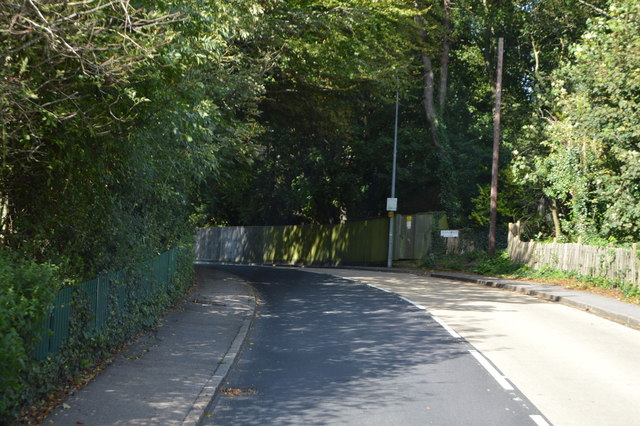
The village of Playden is known for its picturesque setting, nestled amidst the rolling hills and beautiful countryside of Sussex. It is characterized by its charming old houses, many of which date back to the 17th and 18th centuries, giving the village a timeless and traditional feel.

One of the notable landmarks in Playden is the Church of St. Michael and All Angels, a Grade I listed building that has stood for over 800 years. This medieval church features stunning architecture and is known for its ornate stained glass windows and ancient wall paintings.

The area surrounding Playden offers plenty of opportunities for outdoor activities, with numerous footpaths and bridleways crisscrossing the countryside. Visitors can enjoy walks through fields and woodlands, taking in the scenic views of the Sussex landscape.

Despite its small size, Playden has a strong sense of community and hosts various events throughout the year, including village fairs and social gatherings. The village also has a primary school, providing education for local children.

Overall, Playden is a picturesque and historic village in Sussex, offering a tranquil and idyllic setting for residents and visitors alike.

If you have any feedback on the listing, please let us know in the comments section below.

Playden Images

Images are sourced within 2km of 50.972749/0.750148 or Grid Reference TQ9322. Thanks to Geograph Open Source API. All images are credited.

Ivy-clad building This stands beside a metalled track leading to Spring and Cliff Farms. The water in the foreground is Boonshill Petty Sewer.
Ivy-clad building
This stands beside a metalled track leading to Spring and Cliff Farms. The water in the foreground is Boonshill Petty Sewer.
Wind farm in the distance
Salt Farm
Salt Farm
St Johns Cottage
St Johns Cottage
Salts Farm
Salts Farm
Rye Hill, A268 The A268 is a 16 mile long A road that runs from the A21 at Flimwell <a href="https://www.geograph.org.uk/photo/6738170">TQ7131 : A268 off A21</a>, on the Kent - East Sussex Border to Rye in East Sussex, via Hawkhurst.
Rye Hill, A268
The A268 is a 16 mile long A road that runs from the A21 at Flimwell TQ7131 : A268 off A21, on the Kent - East Sussex Border to Rye in East Sussex, via Hawkhurst.
Ordnance Survey Flush Bracket G1869 This can be found on the wall of All Saints Church at Iden.
For more detail see : <span class="nowrap"><a title="http://www.bench-marks.org.uk/bm14991" rel="nofollow ugc noopener" href="http://www.bench-marks.org.uk/bm14991">Link</a><img style="margin-left:2px;" alt="External link" title="External link - shift click to open in new window" src="https://s1.geograph.org.uk/img/external.png" width="10" height="10"/></span>
Ordnance Survey Flush Bracket G1869
This can be found on the wall of All Saints Church at Iden. For more detail see : LinkExternal link
All Saints Church at Iden Viewed from the south-east.
All Saints Church at Iden
Viewed from the south-east.
Ordnance Survey Flush Bracket 2841 This can be found on the wall of the Old Post Office - now a private dwelling - at Playden.
For more detail see : <span class="nowrap"><a title="http://www.bench-marks.org.uk/bm11989" rel="nofollow ugc noopener" href="http://www.bench-marks.org.uk/bm11989">Link</a><img style="margin-left:2px;" alt="External link" title="External link - shift click to open in new window" src="https://s1.geograph.org.uk/img/external.png" width="10" height="10"/></span>
Ordnance Survey Flush Bracket 2841
This can be found on the wall of the Old Post Office - now a private dwelling - at Playden. For more detail see : LinkExternal link
Haoughton Green Lane at its junction with the A268 Looking eastward.
Haoughton Green Lane at its junction with the A268
Looking eastward.
The Church of St Michael at Playden Viewed from the south-west.
The Church of St Michael at Playden
Viewed from the south-west.
Ordnance Survey Cut Mark with Bolt This can be found on the wall of St Michael's Church in Playden.
For more detail see : <span class="nowrap"><a title="http://www.bench-marks.org.uk/bm38626" rel="nofollow ugc noopener" href="http://www.bench-marks.org.uk/bm38626">Link</a><img style="margin-left:2px;" alt="External link" title="External link - shift click to open in new window" src="https://s1.geograph.org.uk/img/external.png" width="10" height="10"/></span>
Ordnance Survey Cut Mark with Bolt
This can be found on the wall of St Michael's Church in Playden. For more detail see : LinkExternal link
Romney Marsh at East Guldeford Romney Marsh is famous for its sheep but there are other animals
Romney Marsh at East Guldeford
Romney Marsh is famous for its sheep but there are other animals
River Rother  just East of Rye In summer this stretch of the river is lined with moored boats. Photo taken in November when some have been moved up onto the bank.
River Rother just East of Rye
In summer this stretch of the river is lined with moored boats. Photo taken in November when some have been moved up onto the bank.
River Rother from the Iden Lock bridge
Royal Military Canal at the Iden Lock bridge
Royal Military Canal joins the River Rother Seen from the Iden Lock bridge above the canal looking towards Rye.

The river turns North and passes under Military Road
Royal Military Canal joins the River Rother
Seen from the Iden Lock bridge above the canal looking towards Rye. The river turns North and passes under Military Road
Camber Rd
Camber Rd
Show me another place!

Playden is located at Grid Ref: TQ9322 (Lat: 50.972749, Lng: 0.750148)

Administrative County: East Sussex

District: Rother

Police Authority: Sussex

What 3 Words

///alert.dissolve.series. Near Rye, East Sussex

Nearby Locations

Playden

Related Wikis

Houghton Green Cliff

Houghton Green Cliff is a 0.14-hectare (0.35-acre) geological Site of Special Scientific Interest north of Rye in East Sussex, United Kingdom. It is a...

Royal Military Canal

The Royal Military Canal is a canal running for 28 miles (45 km) between Seabrook near Folkestone and Cliff End near Hastings, following the old cliff...

Playden

Playden is a village and civil parish in the Rother district of East Sussex, England. The village is located one mile (1.6 km) north-west of Rye. ��2...

East Guldeford

East Guldeford is a village and civil parish in the Rother district of East Sussex, England. The village is located one mile (1.6 km) east of Rye on the...

Iden, East Sussex

Iden is a village and civil parish in the Rother district of East Sussex, England. The village is located two miles (3.2 km) north of Rye. Iden 12th/13th...

Rye railway station (Rye and Camber Tramway)

Rye railway station was a terminal station on the Rye and Camber Tramway in East Sussex, connecting Rye to Camber. Although the station was close to the...
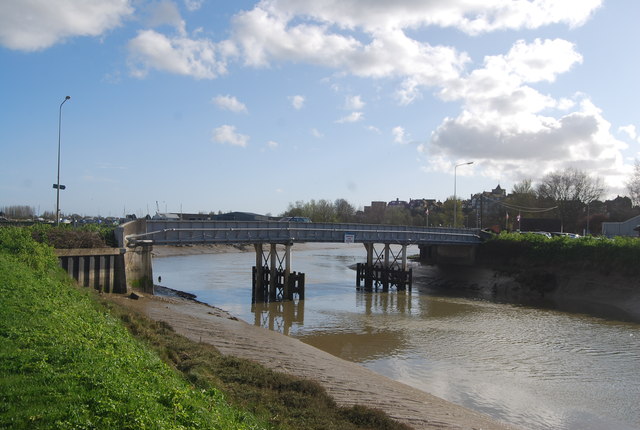
Monk Bretton Bridge

The Monk Bretton Bridge is a road bridge over the River Rother in Rye, East Sussex. It carries the A259 road, a major road between Folkestone and Hastings...

Rye Studio School

Rye Studio School was a mixed studio school located in Rye, East Sussex, England. It opened in 2013 and catered for students aged 14–19 years. It was located...

Nearby Amenities

Located within 500m of 50.972749,0.750148
Post Box
Operator: Royal Mail
Operator Wikidata: Q638098
Postal Code: TN31
Ref: TN31 20
Source: survey
Lat/Long: 50.9713286/0.7515161
Source: Bing
Waterway: weir
Lat/Long: 50.9697135/0.75044
Power: pole
Lat/Long: 50.9718804/0.748739
Power: pole
Lat/Long: 50.9728178/0.7439553
Power: pole
Lat/Long: 50.9713669/0.7510984
Power: pole
Lat/Long: 50.9721224/0.7474313
Power: pole
Lat/Long: 50.9716483/0.7499308
Power: pole
Lat/Long: 50.9724667/0.7457553
Barrier: kissing_gate
Source: survey
Lat/Long: 50.9693282/0.7507191
Seamark Type: gate
Waterway: lock_gate
Lat/Long: 50.969417/0.7503173
Seamark Type: gate
Waterway: lock_gate
Lat/Long: 50.9696062/0.7505306
The data included in this document is from www.openstreetmap.org. The data is made available under ODbL.

Have you been to Playden?

Leave your review of Playden below (or comments, questions and feedback).