Broxburn

Settlement in West Lothian

Scotland

Broxburn

Arable land, Kilpunt
Arable land, Kilpunt Credit: Richard Webb

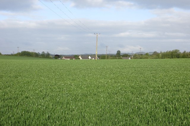
Broxburn is a small town located in West Lothian, Scotland, with a population of around 8,000 people. Situated approximately 12 miles west of Edinburgh, it is part of the wider Edinburgh Metropolitan Area. The town lies on the A8 road, providing easy access to both Edinburgh and Glasgow.

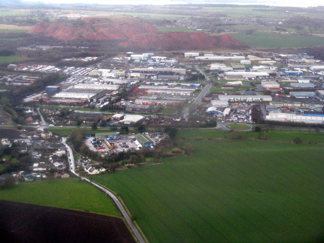
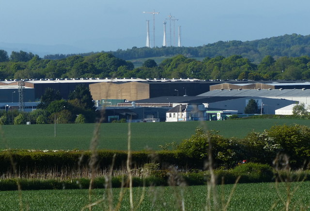
Broxburn has a rich industrial history, primarily rooted in shale oil mining and the production of bricks. In the late 19th and early 20th centuries, the town was home to several oil works and brickworks, which significantly contributed to the local economy. Although these industries have declined, their legacy can still be seen in the town's architecture.

Today, Broxburn serves as a residential area with a range of amenities for its residents. The town features several shops, supermarkets, and local businesses, providing essential services and employment opportunities. The town's location makes it an attractive option for commuters working in nearby cities, with regular bus services and access to the M8 motorway.

Broxburn also offers a variety of recreational activities. The town has a public park, Broxburn Community Woodland, which provides a pleasant green space for walking and relaxation. Sports enthusiasts can enjoy facilities such as the Broxburn United Sports Club, which offers football, rugby, and tennis. Additionally, the town hosts various community events throughout the year, including the annual Broxburn Gala Day.

In summary, Broxburn is a small town in West Lothian, Scotland, with a rich industrial heritage. It provides a range of amenities for its residents and is well-connected to nearby cities, making it an attractive place to live for both commuters and those seeking a quiet residential area.

If you have any feedback on the listing, please let us know in the comments section below.

Broxburn Images

Images are sourced within 2km of 55.934334/-3.469466 or Grid Reference NT0872. Thanks to Geograph Open Source API. All images are credited.

Arable land, Kilpunt
Roman Camp Cottages Seen from the air on the way to Edinburgh Airport. Just beyond are the Edinburgh-Helensburgh railway and the M8.
Roman Camp Cottages
Seen from the air on the way to Edinburgh Airport. Just beyond are the Edinburgh-Helensburgh railway and the M8.
The Union Canal near Broxburn Passing through farmland at Powflats. Broxburn is beyond the A89 - the straight line that separates the fields from the houses.
The Union Canal near Broxburn
Passing through farmland at Powflats. Broxburn is beyond the A89 - the straight line that separates the fields from the houses.
The Union Canal at Learielaw With boat. An aerial view looking northwest. The towpath also serves as NCN754.
The Union Canal at Learielaw
With boat. An aerial view looking northwest. The towpath also serves as NCN754.
Burnside at Broxburn Farmland at Kilpunt and the East Mains Industrial Estate, with the Greendykes Bing in the distance.
Burnside at Broxburn
Farmland at Kilpunt and the East Mains Industrial Estate, with the Greendykes Bing in the distance.
Muirend Bridge No 20 Carrying Newhouses Road across the Union Canal near Muirend.
Muirend Bridge No 20
Carrying Newhouses Road across the Union Canal near Muirend.
Union Canal near Muirend Bridge No 20 Following the completion and opening of the Forth and Clyde Canal in 1790, it was not long before the idea arose of a canal to link Edinburgh to the west, and in particular to the coal mining areas in the west of Scotland, to enable coal to be supplied more cheaply to the capital. Other commodities suited for canal transport included building stone and lime. 

It took another two decades, however, before a survey was undertaken of a route that would link the proposed canal to the Forth and Clyde Canal at Falkirk. The necessary Act of Parliament authorising construction was passed in 1817, and work started at the Edinburgh end, at Port Hopetoun, the following year.

The canal was designed by Hugh Baird <span class="nowrap"><a title="http://en.wikipedia.org/wiki/Hugh_Baird_%28engineer%29" rel="nofollow ugc noopener" href="http://en.wikipedia.org/wiki/Hugh_Baird_%28engineer%29">Link</a><img style="margin-left:2px;" alt="External link" title="External link - shift click to open in new window" src="https://s1.geograph.org.uk/img/external.png" width="10" height="10"/></span> and Thomas Telford <span class="nowrap"><a title="http://en.wikipedia.org/wiki/Thomas_Telford" rel="nofollow ugc noopener" href="http://en.wikipedia.org/wiki/Thomas_Telford">Link</a><img style="margin-left:2px;" alt="External link" title="External link - shift click to open in new window" src="https://s1.geograph.org.uk/img/external.png" width="10" height="10"/></span> and <a title="https://www.geograph.org.uk/discuss/?action=vthread&forum=6&topic=5666" href="https://www.geograph.org.uk/discuss/?action=vthread&forum=6&topic=5666">Link</a> on behalf of the Edinburgh and Glasgow Union Canal Company, whose 384 shareholders included the Lord Provost of Edinburgh and a number of titled persons. 

The canal was originally 32 miles in length and 5 feet deep, and it is a contour canal, that is, it follows the 241 foot (73 metre) contour, except for three river valleys where major aqueducts had to be built to carry the canal across at this height. These are the Slateford Aqueduct over the Water of Leith, the Almond Aqueduct 75 feet (23 metres) above the River Almond at Lin's Mill, and the longest of all at 810 feet (250 metres), the Avon Aqueduct, 86 feet (36 metres) above  the River Avon near Linlithgow. 

Most of the 60-odd bridges are fixed, so neither locks nor opening bridges delayed navigation most of the way, though the aqueducts were only wide enough for boats and barges to travel in one direction at a time; oncoming vessels had to wait until the way was clear. 

A tunnel 690 yards (636 metres) in length was required near Falkirk because the owner of Callendar House, William Forbes,  refused to allow the canal to pass through his land, and this undertaking contributed to the final cost being almost double the original estimate of £240,500. The final bill of over £460,000 equates to anything between £2000 million and £380,000 million at 2014 prices, depending on how it is calculated. 

The water level is maintained from a reservoir in the Pentland Hills, a three-mile channel from the River Almond, and other feeders. 

At Falkirk the Union Canal was 110 feet (33 metres) above the level of the Forth and Clyde Canal, and a flight of eleven locks was built to link the two canals. 

Construction took just four years, and the canal opened for traffic in 1822. Tolls were charged for the carriage of goods, and fares for passengers. There was also income from wharfage. Maximum charges were laid down in the enabling Act of Parliament. The Company was required to pay duties on goods carried to the Burgh of Linlithgow and the City of Edinburgh because the canal took trade away from the turnpike roads maintained by the respective councils.

Early trade was brisk, but unfortunately its heyday lasted only about 20 years, until the Edinburgh and Glasgow Railway superseded it in 1842, and in 1849 the canal was acquired by the railway company. Its use declined steadily over the years, and in the 1930s the flight of eleven locks at Falkirk was filled in and built on. Other stretches of the canal in Edinburgh were also built on, including the Edinburgh terminus. The City Bypass cut the route west of Edinburgh, and the M8 motorway blocked it near Broxburn. The canal was officially closed in 1965, though various stretches were used recreationally, for example for rowing and angling.

Towards the end of the 20th century there was a revival of interest in canals, mainly for recreational use, and the restoration of the Forth and Clyde Canal and the Union Canal was mooted. The project was adopted as one of the major undertakings to mark the millennium, and obtained funding from the European Union and the Millennium Commission among others. A new terminus with associated new retail, residential and commercial buildings was created in Edinburgh and a new stretch of canal dug to replace the section built on at Wester Hailes. The Scott Russell Aqueduct (named after John Scott Russell, who first observed a soliton wave on the canal in 1834) now carries the canal over the City Bypass, and a diversion was built to pass beneath the M8 motorway. The final piece of the restoration was the unique Falkirk Wheel, at the end of an extension to the original canal at Falkirk, which lifts and lowers boats between the Union Canal and the Forth and Clyde Canal. 

The Millennium Link restoration cost some £84 million and the restored canal was opened in 2001. The Falkirk Wheel was opened by Her Majesty Queen Elizabeth the following year.
Union Canal near Muirend Bridge No 20
Following the completion and opening of the Forth and Clyde Canal in 1790, it was not long before the idea arose of a canal to link Edinburgh to the west, and in particular to the coal mining areas in the west of Scotland, to enable coal to be supplied more cheaply to the capital. Other commodities suited for canal transport included building stone and lime. It took another two decades, however, before a survey was undertaken of a route that would link the proposed canal to the Forth and Clyde Canal at Falkirk. The necessary Act of Parliament authorising construction was passed in 1817, and work started at the Edinburgh end, at Port Hopetoun, the following year. The canal was designed by Hugh Baird LinkExternal link and Thomas Telford LinkExternal link and Link on behalf of the Edinburgh and Glasgow Union Canal Company, whose 384 shareholders included the Lord Provost of Edinburgh and a number of titled persons. The canal was originally 32 miles in length and 5 feet deep, and it is a contour canal, that is, it follows the 241 foot (73 metre) contour, except for three river valleys where major aqueducts had to be built to carry the canal across at this height. These are the Slateford Aqueduct over the Water of Leith, the Almond Aqueduct 75 feet (23 metres) above the River Almond at Lin's Mill, and the longest of all at 810 feet (250 metres), the Avon Aqueduct, 86 feet (36 metres) above the River Avon near Linlithgow. Most of the 60-odd bridges are fixed, so neither locks nor opening bridges delayed navigation most of the way, though the aqueducts were only wide enough for boats and barges to travel in one direction at a time; oncoming vessels had to wait until the way was clear. A tunnel 690 yards (636 metres) in length was required near Falkirk because the owner of Callendar House, William Forbes, refused to allow the canal to pass through his land, and this undertaking contributed to the final cost being almost double the original estimate of £240,500. The final bill of over £460,000 equates to anything between £2000 million and £380,000 million at 2014 prices, depending on how it is calculated. The water level is maintained from a reservoir in the Pentland Hills, a three-mile channel from the River Almond, and other feeders. At Falkirk the Union Canal was 110 feet (33 metres) above the level of the Forth and Clyde Canal, and a flight of eleven locks was built to link the two canals. Construction took just four years, and the canal opened for traffic in 1822. Tolls were charged for the carriage of goods, and fares for passengers. There was also income from wharfage. Maximum charges were laid down in the enabling Act of Parliament. The Company was required to pay duties on goods carried to the Burgh of Linlithgow and the City of Edinburgh because the canal took trade away from the turnpike roads maintained by the respective councils. Early trade was brisk, but unfortunately its heyday lasted only about 20 years, until the Edinburgh and Glasgow Railway superseded it in 1842, and in 1849 the canal was acquired by the railway company. Its use declined steadily over the years, and in the 1930s the flight of eleven locks at Falkirk was filled in and built on. Other stretches of the canal in Edinburgh were also built on, including the Edinburgh terminus. The City Bypass cut the route west of Edinburgh, and the M8 motorway blocked it near Broxburn. The canal was officially closed in 1965, though various stretches were used recreationally, for example for rowing and angling. Towards the end of the 20th century there was a revival of interest in canals, mainly for recreational use, and the restoration of the Forth and Clyde Canal and the Union Canal was mooted. The project was adopted as one of the major undertakings to mark the millennium, and obtained funding from the European Union and the Millennium Commission among others. A new terminus with associated new retail, residential and commercial buildings was created in Edinburgh and a new stretch of canal dug to replace the section built on at Wester Hailes. The Scott Russell Aqueduct (named after John Scott Russell, who first observed a soliton wave on the canal in 1834) now carries the canal over the City Bypass, and a diversion was built to pass beneath the M8 motorway. The final piece of the restoration was the unique Falkirk Wheel, at the end of an extension to the original canal at Falkirk, which lifts and lowers boats between the Union Canal and the Forth and Clyde Canal. The Millennium Link restoration cost some £84 million and the restored canal was opened in 2001. The Falkirk Wheel was opened by Her Majesty Queen Elizabeth the following year.
Railway bridge crossing the Union Canal Following the completion and opening of the Forth and Clyde Canal in 1790, it was not long before the idea arose of a canal to link Edinburgh to the west, and in particular to the coal mining areas in the west of Scotland, to enable coal to be supplied more cheaply to the capital. Other commodities suited for canal transport included building stone and lime. 

It took another two decades, however, before a survey was undertaken of a route that would link the proposed canal to the Forth and Clyde Canal at Falkirk. The necessary Act of Parliament authorising construction was passed in 1817, and work started at the Edinburgh end, at Port Hopetoun, the following year.

The canal was designed by Hugh Baird <span class="nowrap"><a title="http://en.wikipedia.org/wiki/Hugh_Baird_%28engineer%29" rel="nofollow ugc noopener" href="http://en.wikipedia.org/wiki/Hugh_Baird_%28engineer%29">Link</a><img style="margin-left:2px;" alt="External link" title="External link - shift click to open in new window" src="https://s1.geograph.org.uk/img/external.png" width="10" height="10"/></span> and Thomas Telford <span class="nowrap"><a title="http://en.wikipedia.org/wiki/Thomas_Telford" rel="nofollow ugc noopener" href="http://en.wikipedia.org/wiki/Thomas_Telford">Link</a><img style="margin-left:2px;" alt="External link" title="External link - shift click to open in new window" src="https://s1.geograph.org.uk/img/external.png" width="10" height="10"/></span> and <a title="https://www.geograph.org.uk/discuss/?action=vthread&forum=6&topic=5666" href="https://www.geograph.org.uk/discuss/?action=vthread&forum=6&topic=5666">Link</a> on behalf of the Edinburgh and Glasgow Union Canal Company, whose 384 shareholders included the Lord Provost of Edinburgh and a number of titled persons. 

The canal was originally 32 miles in length and 5 feet deep, and it is a contour canal, that is, it follows the 241 foot (73 metre) contour, except for three river valleys where major aqueducts had to be built to carry the canal across at this height. These are the Slateford Aqueduct over the Water of Leith, the Almond Aqueduct 75 feet (23 metres) above the River Almond at Lin's Mill, and the longest of all at 810 feet (250 metres), the Avon Aqueduct, 86 feet (36 metres) above  the River Avon near Linlithgow. 

Most of the 60-odd bridges are fixed, so neither locks nor opening bridges delayed navigation most of the way, though the aqueducts were only wide enough for boats and barges to travel in one direction at a time; oncoming vessels had to wait until the way was clear. 

A tunnel 690 yards (636 metres) in length was required near Falkirk because the owner of Callendar House, William Forbes,  refused to allow the canal to pass through his land, and this undertaking contributed to the final cost being almost double the original estimate of £240,500. The final bill of over £460,000 equates to anything between £2000 million and £380,000 million at 2014 prices, depending on how it is calculated. 

The water level is maintained from a reservoir in the Pentland Hills, a three-mile channel from the River Almond, and other feeders. 

At Falkirk the Union Canal was 110 feet (33 metres) above the level of the Forth and Clyde Canal, and a flight of eleven locks was built to link the two canals. 

Construction took just four years, and the canal opened for traffic in 1822. Tolls were charged for the carriage of goods, and fares for passengers. There was also income from wharfage. Maximum charges were laid down in the enabling Act of Parliament. The Company was required to pay duties on goods carried to the Burgh of Linlithgow and the City of Edinburgh because the canal took trade away from the turnpike roads maintained by the respective councils.

Early trade was brisk, but unfortunately its heyday lasted only about 20 years, until the Edinburgh and Glasgow Railway superseded it in 1842, and in 1849 the canal was acquired by the railway company. Its use declined steadily over the years, and in the 1930s the flight of eleven locks at Falkirk was filled in and built on. Other stretches of the canal in Edinburgh were also built on, including the Edinburgh terminus. The City Bypass cut the route west of Edinburgh, and the M8 motorway blocked it near Broxburn. The canal was officially closed in 1965, though various stretches were used recreationally, for example for rowing and angling.

Towards the end of the 20th century there was a revival of interest in canals, mainly for recreational use, and the restoration of the Forth and Clyde Canal and the Union Canal was mooted. The project was adopted as one of the major undertakings to mark the millennium, and obtained funding from the European Union and the Millennium Commission among others. A new terminus with associated new retail, residential and commercial buildings was created in Edinburgh and a new stretch of canal dug to replace the section built on at Wester Hailes. The Scott Russell Aqueduct (named after John Scott Russell, who first observed a soliton wave on the canal in 1834) now carries the canal over the City Bypass, and a diversion was built to pass beneath the M8 motorway. The final piece of the restoration was the unique Falkirk Wheel, at the end of an extension to the original canal at Falkirk, which lifts and lowers boats between the Union Canal and the Forth and Clyde Canal. 

The Millennium Link restoration cost some £84 million and the restored canal was opened in 2001. The Falkirk Wheel was opened by Her Majesty Queen Elizabeth the following year.
Railway bridge crossing the Union Canal
Following the completion and opening of the Forth and Clyde Canal in 1790, it was not long before the idea arose of a canal to link Edinburgh to the west, and in particular to the coal mining areas in the west of Scotland, to enable coal to be supplied more cheaply to the capital. Other commodities suited for canal transport included building stone and lime. It took another two decades, however, before a survey was undertaken of a route that would link the proposed canal to the Forth and Clyde Canal at Falkirk. The necessary Act of Parliament authorising construction was passed in 1817, and work started at the Edinburgh end, at Port Hopetoun, the following year. The canal was designed by Hugh Baird LinkExternal link and Thomas Telford LinkExternal link and Link on behalf of the Edinburgh and Glasgow Union Canal Company, whose 384 shareholders included the Lord Provost of Edinburgh and a number of titled persons. The canal was originally 32 miles in length and 5 feet deep, and it is a contour canal, that is, it follows the 241 foot (73 metre) contour, except for three river valleys where major aqueducts had to be built to carry the canal across at this height. These are the Slateford Aqueduct over the Water of Leith, the Almond Aqueduct 75 feet (23 metres) above the River Almond at Lin's Mill, and the longest of all at 810 feet (250 metres), the Avon Aqueduct, 86 feet (36 metres) above the River Avon near Linlithgow. Most of the 60-odd bridges are fixed, so neither locks nor opening bridges delayed navigation most of the way, though the aqueducts were only wide enough for boats and barges to travel in one direction at a time; oncoming vessels had to wait until the way was clear. A tunnel 690 yards (636 metres) in length was required near Falkirk because the owner of Callendar House, William Forbes, refused to allow the canal to pass through his land, and this undertaking contributed to the final cost being almost double the original estimate of £240,500. The final bill of over £460,000 equates to anything between £2000 million and £380,000 million at 2014 prices, depending on how it is calculated. The water level is maintained from a reservoir in the Pentland Hills, a three-mile channel from the River Almond, and other feeders. At Falkirk the Union Canal was 110 feet (33 metres) above the level of the Forth and Clyde Canal, and a flight of eleven locks was built to link the two canals. Construction took just four years, and the canal opened for traffic in 1822. Tolls were charged for the carriage of goods, and fares for passengers. There was also income from wharfage. Maximum charges were laid down in the enabling Act of Parliament. The Company was required to pay duties on goods carried to the Burgh of Linlithgow and the City of Edinburgh because the canal took trade away from the turnpike roads maintained by the respective councils. Early trade was brisk, but unfortunately its heyday lasted only about 20 years, until the Edinburgh and Glasgow Railway superseded it in 1842, and in 1849 the canal was acquired by the railway company. Its use declined steadily over the years, and in the 1930s the flight of eleven locks at Falkirk was filled in and built on. Other stretches of the canal in Edinburgh were also built on, including the Edinburgh terminus. The City Bypass cut the route west of Edinburgh, and the M8 motorway blocked it near Broxburn. The canal was officially closed in 1965, though various stretches were used recreationally, for example for rowing and angling. Towards the end of the 20th century there was a revival of interest in canals, mainly for recreational use, and the restoration of the Forth and Clyde Canal and the Union Canal was mooted. The project was adopted as one of the major undertakings to mark the millennium, and obtained funding from the European Union and the Millennium Commission among others. A new terminus with associated new retail, residential and commercial buildings was created in Edinburgh and a new stretch of canal dug to replace the section built on at Wester Hailes. The Scott Russell Aqueduct (named after John Scott Russell, who first observed a soliton wave on the canal in 1834) now carries the canal over the City Bypass, and a diversion was built to pass beneath the M8 motorway. The final piece of the restoration was the unique Falkirk Wheel, at the end of an extension to the original canal at Falkirk, which lifts and lowers boats between the Union Canal and the Forth and Clyde Canal. The Millennium Link restoration cost some £84 million and the restored canal was opened in 2001. The Falkirk Wheel was opened by Her Majesty Queen Elizabeth the following year.
Farmland north of the Union Canal Looking towards the East Mains Industrial Estate in Broxburn.
On the horizon, five and a half miles away, are the three towers of the new Queensferry Crossing. The towers are 200 metres in height, making it the tallest bridge in the UK.
Farmland north of the Union Canal
Looking towards the East Mains Industrial Estate in Broxburn. On the horizon, five and a half miles away, are the three towers of the new Queensferry Crossing. The towers are 200 metres in height, making it the tallest bridge in the UK.
Underneath Bridge No 21 on the Union Canal Following the completion and opening of the Forth and Clyde Canal in 1790, it was not long before the idea arose of a canal to link Edinburgh to the west, and in particular to the coal mining areas in the west of Scotland, to enable coal to be supplied more cheaply to the capital. Other commodities suited for canal transport included building stone and lime. 

It took another two decades, however, before a survey was undertaken of a route that would link the proposed canal to the Forth and Clyde Canal at Falkirk. The necessary Act of Parliament authorising construction was passed in 1817, and work started at the Edinburgh end, at Port Hopetoun, the following year.

The canal was designed by Hugh Baird <span class="nowrap"><a title="http://en.wikipedia.org/wiki/Hugh_Baird_%28engineer%29" rel="nofollow ugc noopener" href="http://en.wikipedia.org/wiki/Hugh_Baird_%28engineer%29">Link</a><img style="margin-left:2px;" alt="External link" title="External link - shift click to open in new window" src="https://s1.geograph.org.uk/img/external.png" width="10" height="10"/></span> and Thomas Telford <span class="nowrap"><a title="http://en.wikipedia.org/wiki/Thomas_Telford" rel="nofollow ugc noopener" href="http://en.wikipedia.org/wiki/Thomas_Telford">Link</a><img style="margin-left:2px;" alt="External link" title="External link - shift click to open in new window" src="https://s1.geograph.org.uk/img/external.png" width="10" height="10"/></span> and <a title="https://www.geograph.org.uk/discuss/?action=vthread&forum=6&topic=5666" href="https://www.geograph.org.uk/discuss/?action=vthread&forum=6&topic=5666">Link</a> on behalf of the Edinburgh and Glasgow Union Canal Company, whose 384 shareholders included the Lord Provost of Edinburgh and a number of titled persons. 

The canal was originally 32 miles in length and 5 feet deep, and it is a contour canal, that is, it follows the 241 foot (73 metre) contour, except for three river valleys where major aqueducts had to be built to carry the canal across at this height. These are the Slateford Aqueduct over the Water of Leith, the Almond Aqueduct 75 feet (23 metres) above the River Almond at Lin's Mill, and the longest of all at 810 feet (250 metres), the Avon Aqueduct, 86 feet (36 metres) above  the River Avon near Linlithgow. 

Most of the 60-odd bridges are fixed, so neither locks nor opening bridges delayed navigation most of the way, though the aqueducts were only wide enough for boats and barges to travel in one direction at a time; oncoming vessels had to wait until the way was clear. 

A tunnel 690 yards (636 metres) in length was required near Falkirk because the owner of Callendar House, William Forbes,  refused to allow the canal to pass through his land, and this undertaking contributed to the final cost being almost double the original estimate of £240,500. The final bill of over £460,000 equates to anything between £2000 million and £380,000 million at 2014 prices, depending on how it is calculated. 

The water level is maintained from a reservoir in the Pentland Hills, a three-mile channel from the River Almond, and other feeders. 

At Falkirk the Union Canal was 110 feet (33 metres) above the level of the Forth and Clyde Canal, and a flight of eleven locks was built to link the two canals. 

Construction took just four years, and the canal opened for traffic in 1822. Tolls were charged for the carriage of goods, and fares for passengers. There was also income from wharfage. Maximum charges were laid down in the enabling Act of Parliament. The Company was required to pay duties on goods carried to the Burgh of Linlithgow and the City of Edinburgh because the canal took trade away from the turnpike roads maintained by the respective councils.

Early trade was brisk, but unfortunately its heyday lasted only about 20 years, until the Edinburgh and Glasgow Railway superseded it in 1842, and in 1849 the canal was acquired by the railway company. Its use declined steadily over the years, and in the 1930s the flight of eleven locks at Falkirk was filled in and built on. Other stretches of the canal in Edinburgh were also built on, including the Edinburgh terminus. The City Bypass cut the route west of Edinburgh, and the M8 motorway blocked it near Broxburn. The canal was officially closed in 1965, though various stretches were used recreationally, for example for rowing and angling.

Towards the end of the 20th century there was a revival of interest in canals, mainly for recreational use, and the restoration of the Forth and Clyde Canal and the Union Canal was mooted. The project was adopted as one of the major undertakings to mark the millennium, and obtained funding from the European Union and the Millennium Commission among others. A new terminus with associated new retail, residential and commercial buildings was created in Edinburgh and a new stretch of canal dug to replace the section built on at Wester Hailes. The Scott Russell Aqueduct (named after John Scott Russell, who first observed a soliton wave on the canal in 1834) now carries the canal over the City Bypass, and a diversion was built to pass beneath the M8 motorway. The final piece of the restoration was the unique Falkirk Wheel, at the end of an extension to the original canal at Falkirk, which lifts and lowers boats between the Union Canal and the Forth and Clyde Canal. 

The Millennium Link restoration cost some £84 million and the restored canal was opened in 2001. The Falkirk Wheel was opened by Her Majesty Queen Elizabeth the following year.
Underneath Bridge No 21 on the Union Canal
Following the completion and opening of the Forth and Clyde Canal in 1790, it was not long before the idea arose of a canal to link Edinburgh to the west, and in particular to the coal mining areas in the west of Scotland, to enable coal to be supplied more cheaply to the capital. Other commodities suited for canal transport included building stone and lime. It took another two decades, however, before a survey was undertaken of a route that would link the proposed canal to the Forth and Clyde Canal at Falkirk. The necessary Act of Parliament authorising construction was passed in 1817, and work started at the Edinburgh end, at Port Hopetoun, the following year. The canal was designed by Hugh Baird LinkExternal link and Thomas Telford LinkExternal link and Link on behalf of the Edinburgh and Glasgow Union Canal Company, whose 384 shareholders included the Lord Provost of Edinburgh and a number of titled persons. The canal was originally 32 miles in length and 5 feet deep, and it is a contour canal, that is, it follows the 241 foot (73 metre) contour, except for three river valleys where major aqueducts had to be built to carry the canal across at this height. These are the Slateford Aqueduct over the Water of Leith, the Almond Aqueduct 75 feet (23 metres) above the River Almond at Lin's Mill, and the longest of all at 810 feet (250 metres), the Avon Aqueduct, 86 feet (36 metres) above the River Avon near Linlithgow. Most of the 60-odd bridges are fixed, so neither locks nor opening bridges delayed navigation most of the way, though the aqueducts were only wide enough for boats and barges to travel in one direction at a time; oncoming vessels had to wait until the way was clear. A tunnel 690 yards (636 metres) in length was required near Falkirk because the owner of Callendar House, William Forbes, refused to allow the canal to pass through his land, and this undertaking contributed to the final cost being almost double the original estimate of £240,500. The final bill of over £460,000 equates to anything between £2000 million and £380,000 million at 2014 prices, depending on how it is calculated. The water level is maintained from a reservoir in the Pentland Hills, a three-mile channel from the River Almond, and other feeders. At Falkirk the Union Canal was 110 feet (33 metres) above the level of the Forth and Clyde Canal, and a flight of eleven locks was built to link the two canals. Construction took just four years, and the canal opened for traffic in 1822. Tolls were charged for the carriage of goods, and fares for passengers. There was also income from wharfage. Maximum charges were laid down in the enabling Act of Parliament. The Company was required to pay duties on goods carried to the Burgh of Linlithgow and the City of Edinburgh because the canal took trade away from the turnpike roads maintained by the respective councils. Early trade was brisk, but unfortunately its heyday lasted only about 20 years, until the Edinburgh and Glasgow Railway superseded it in 1842, and in 1849 the canal was acquired by the railway company. Its use declined steadily over the years, and in the 1930s the flight of eleven locks at Falkirk was filled in and built on. Other stretches of the canal in Edinburgh were also built on, including the Edinburgh terminus. The City Bypass cut the route west of Edinburgh, and the M8 motorway blocked it near Broxburn. The canal was officially closed in 1965, though various stretches were used recreationally, for example for rowing and angling. Towards the end of the 20th century there was a revival of interest in canals, mainly for recreational use, and the restoration of the Forth and Clyde Canal and the Union Canal was mooted. The project was adopted as one of the major undertakings to mark the millennium, and obtained funding from the European Union and the Millennium Commission among others. A new terminus with associated new retail, residential and commercial buildings was created in Edinburgh and a new stretch of canal dug to replace the section built on at Wester Hailes. The Scott Russell Aqueduct (named after John Scott Russell, who first observed a soliton wave on the canal in 1834) now carries the canal over the City Bypass, and a diversion was built to pass beneath the M8 motorway. The final piece of the restoration was the unique Falkirk Wheel, at the end of an extension to the original canal at Falkirk, which lifts and lowers boats between the Union Canal and the Forth and Clyde Canal. The Millennium Link restoration cost some £84 million and the restored canal was opened in 2001. The Falkirk Wheel was opened by Her Majesty Queen Elizabeth the following year.
Bridge No 21 crossing the Union Canal Following the completion and opening of the Forth and Clyde Canal in 1790, it was not long before the idea arose of a canal to link Edinburgh to the west, and in particular to the coal mining areas in the west of Scotland, to enable coal to be supplied more cheaply to the capital. Other commodities suited for canal transport included building stone and lime. 

It took another two decades, however, before a survey was undertaken of a route that would link the proposed canal to the Forth and Clyde Canal at Falkirk. The necessary Act of Parliament authorising construction was passed in 1817, and work started at the Edinburgh end, at Port Hopetoun, the following year.

The canal was designed by Hugh Baird <span class="nowrap"><a title="http://en.wikipedia.org/wiki/Hugh_Baird_%28engineer%29" rel="nofollow ugc noopener" href="http://en.wikipedia.org/wiki/Hugh_Baird_%28engineer%29">Link</a><img style="margin-left:2px;" alt="External link" title="External link - shift click to open in new window" src="https://s1.geograph.org.uk/img/external.png" width="10" height="10"/></span> and Thomas Telford <span class="nowrap"><a title="http://en.wikipedia.org/wiki/Thomas_Telford" rel="nofollow ugc noopener" href="http://en.wikipedia.org/wiki/Thomas_Telford">Link</a><img style="margin-left:2px;" alt="External link" title="External link - shift click to open in new window" src="https://s1.geograph.org.uk/img/external.png" width="10" height="10"/></span> and <a title="https://www.geograph.org.uk/discuss/?action=vthread&forum=6&topic=5666" href="https://www.geograph.org.uk/discuss/?action=vthread&forum=6&topic=5666">Link</a> on behalf of the Edinburgh and Glasgow Union Canal Company, whose 384 shareholders included the Lord Provost of Edinburgh and a number of titled persons. 

The canal was originally 32 miles in length and 5 feet deep, and it is a contour canal, that is, it follows the 241 foot (73 metre) contour, except for three river valleys where major aqueducts had to be built to carry the canal across at this height. These are the Slateford Aqueduct over the Water of Leith, the Almond Aqueduct 75 feet (23 metres) above the River Almond at Lin's Mill, and the longest of all at 810 feet (250 metres), the Avon Aqueduct, 86 feet (36 metres) above  the River Avon near Linlithgow. 

Most of the 60-odd bridges are fixed, so neither locks nor opening bridges delayed navigation most of the way, though the aqueducts were only wide enough for boats and barges to travel in one direction at a time; oncoming vessels had to wait until the way was clear. 

A tunnel 690 yards (636 metres) in length was required near Falkirk because the owner of Callendar House, William Forbes,  refused to allow the canal to pass through his land, and this undertaking contributed to the final cost being almost double the original estimate of £240,500. The final bill of over £460,000 equates to anything between £2000 million and £380,000 million at 2014 prices, depending on how it is calculated. 

The water level is maintained from a reservoir in the Pentland Hills, a three-mile channel from the River Almond, and other feeders. 

At Falkirk the Union Canal was 110 feet (33 metres) above the level of the Forth and Clyde Canal, and a flight of eleven locks was built to link the two canals. 

Construction took just four years, and the canal opened for traffic in 1822. Tolls were charged for the carriage of goods, and fares for passengers. There was also income from wharfage. Maximum charges were laid down in the enabling Act of Parliament. The Company was required to pay duties on goods carried to the Burgh of Linlithgow and the City of Edinburgh because the canal took trade away from the turnpike roads maintained by the respective councils.

Early trade was brisk, but unfortunately its heyday lasted only about 20 years, until the Edinburgh and Glasgow Railway superseded it in 1842, and in 1849 the canal was acquired by the railway company. Its use declined steadily over the years, and in the 1930s the flight of eleven locks at Falkirk was filled in and built on. Other stretches of the canal in Edinburgh were also built on, including the Edinburgh terminus. The City Bypass cut the route west of Edinburgh, and the M8 motorway blocked it near Broxburn. The canal was officially closed in 1965, though various stretches were used recreationally, for example for rowing and angling.

Towards the end of the 20th century there was a revival of interest in canals, mainly for recreational use, and the restoration of the Forth and Clyde Canal and the Union Canal was mooted. The project was adopted as one of the major undertakings to mark the millennium, and obtained funding from the European Union and the Millennium Commission among others. A new terminus with associated new retail, residential and commercial buildings was created in Edinburgh and a new stretch of canal dug to replace the section built on at Wester Hailes. The Scott Russell Aqueduct (named after John Scott Russell, who first observed a soliton wave on the canal in 1834) now carries the canal over the City Bypass, and a diversion was built to pass beneath the M8 motorway. The final piece of the restoration was the unique Falkirk Wheel, at the end of an extension to the original canal at Falkirk, which lifts and lowers boats between the Union Canal and the Forth and Clyde Canal. 

The Millennium Link restoration cost some £84 million and the restored canal was opened in 2001. The Falkirk Wheel was opened by Her Majesty Queen Elizabeth the following year.
Bridge No 21 crossing the Union Canal
Following the completion and opening of the Forth and Clyde Canal in 1790, it was not long before the idea arose of a canal to link Edinburgh to the west, and in particular to the coal mining areas in the west of Scotland, to enable coal to be supplied more cheaply to the capital. Other commodities suited for canal transport included building stone and lime. It took another two decades, however, before a survey was undertaken of a route that would link the proposed canal to the Forth and Clyde Canal at Falkirk. The necessary Act of Parliament authorising construction was passed in 1817, and work started at the Edinburgh end, at Port Hopetoun, the following year. The canal was designed by Hugh Baird LinkExternal link and Thomas Telford LinkExternal link and Link on behalf of the Edinburgh and Glasgow Union Canal Company, whose 384 shareholders included the Lord Provost of Edinburgh and a number of titled persons. The canal was originally 32 miles in length and 5 feet deep, and it is a contour canal, that is, it follows the 241 foot (73 metre) contour, except for three river valleys where major aqueducts had to be built to carry the canal across at this height. These are the Slateford Aqueduct over the Water of Leith, the Almond Aqueduct 75 feet (23 metres) above the River Almond at Lin's Mill, and the longest of all at 810 feet (250 metres), the Avon Aqueduct, 86 feet (36 metres) above the River Avon near Linlithgow. Most of the 60-odd bridges are fixed, so neither locks nor opening bridges delayed navigation most of the way, though the aqueducts were only wide enough for boats and barges to travel in one direction at a time; oncoming vessels had to wait until the way was clear. A tunnel 690 yards (636 metres) in length was required near Falkirk because the owner of Callendar House, William Forbes, refused to allow the canal to pass through his land, and this undertaking contributed to the final cost being almost double the original estimate of £240,500. The final bill of over £460,000 equates to anything between £2000 million and £380,000 million at 2014 prices, depending on how it is calculated. The water level is maintained from a reservoir in the Pentland Hills, a three-mile channel from the River Almond, and other feeders. At Falkirk the Union Canal was 110 feet (33 metres) above the level of the Forth and Clyde Canal, and a flight of eleven locks was built to link the two canals. Construction took just four years, and the canal opened for traffic in 1822. Tolls were charged for the carriage of goods, and fares for passengers. There was also income from wharfage. Maximum charges were laid down in the enabling Act of Parliament. The Company was required to pay duties on goods carried to the Burgh of Linlithgow and the City of Edinburgh because the canal took trade away from the turnpike roads maintained by the respective councils. Early trade was brisk, but unfortunately its heyday lasted only about 20 years, until the Edinburgh and Glasgow Railway superseded it in 1842, and in 1849 the canal was acquired by the railway company. Its use declined steadily over the years, and in the 1930s the flight of eleven locks at Falkirk was filled in and built on. Other stretches of the canal in Edinburgh were also built on, including the Edinburgh terminus. The City Bypass cut the route west of Edinburgh, and the M8 motorway blocked it near Broxburn. The canal was officially closed in 1965, though various stretches were used recreationally, for example for rowing and angling. Towards the end of the 20th century there was a revival of interest in canals, mainly for recreational use, and the restoration of the Forth and Clyde Canal and the Union Canal was mooted. The project was adopted as one of the major undertakings to mark the millennium, and obtained funding from the European Union and the Millennium Commission among others. A new terminus with associated new retail, residential and commercial buildings was created in Edinburgh and a new stretch of canal dug to replace the section built on at Wester Hailes. The Scott Russell Aqueduct (named after John Scott Russell, who first observed a soliton wave on the canal in 1834) now carries the canal over the City Bypass, and a diversion was built to pass beneath the M8 motorway. The final piece of the restoration was the unique Falkirk Wheel, at the end of an extension to the original canal at Falkirk, which lifts and lowers boats between the Union Canal and the Forth and Clyde Canal. The Millennium Link restoration cost some £84 million and the restored canal was opened in 2001. The Falkirk Wheel was opened by Her Majesty Queen Elizabeth the following year.
M8 motorway Bridge No 21a Dated MM (2000), this bridge carries the M8 motorway across the Union Canal near Broxburn.
M8 motorway Bridge No 21a
Dated MM (2000), this bridge carries the M8 motorway across the Union Canal near Broxburn.
Learielaw Bridge No 22 Crossing the Union Canal at Learielaw Farm.
Learielaw Bridge No 22
Crossing the Union Canal at Learielaw Farm.
Union Canal at Learielaw Bridge No 22 Following the completion and opening of the Forth and Clyde Canal in 1790, it was not long before the idea arose of a canal to link Edinburgh to the west, and in particular to the coal mining areas in the west of Scotland, to enable coal to be supplied more cheaply to the capital. Other commodities suited for canal transport included building stone and lime. 

It took another two decades, however, before a survey was undertaken of a route that would link the proposed canal to the Forth and Clyde Canal at Falkirk. The necessary Act of Parliament authorising construction was passed in 1817, and work started at the Edinburgh end, at Port Hopetoun, the following year.

The canal was designed by Hugh Baird <span class="nowrap"><a title="http://en.wikipedia.org/wiki/Hugh_Baird_%28engineer%29" rel="nofollow ugc noopener" href="http://en.wikipedia.org/wiki/Hugh_Baird_%28engineer%29">Link</a><img style="margin-left:2px;" alt="External link" title="External link - shift click to open in new window" src="https://s1.geograph.org.uk/img/external.png" width="10" height="10"/></span> and Thomas Telford <span class="nowrap"><a title="http://en.wikipedia.org/wiki/Thomas_Telford" rel="nofollow ugc noopener" href="http://en.wikipedia.org/wiki/Thomas_Telford">Link</a><img style="margin-left:2px;" alt="External link" title="External link - shift click to open in new window" src="https://s1.geograph.org.uk/img/external.png" width="10" height="10"/></span> and <a title="https://www.geograph.org.uk/discuss/?action=vthread&forum=6&topic=5666" href="https://www.geograph.org.uk/discuss/?action=vthread&forum=6&topic=5666">Link</a> on behalf of the Edinburgh and Glasgow Union Canal Company, whose 384 shareholders included the Lord Provost of Edinburgh and a number of titled persons. 

The canal was originally 32 miles in length and 5 feet deep, and it is a contour canal, that is, it follows the 241 foot (73 metre) contour, except for three river valleys where major aqueducts had to be built to carry the canal across at this height. These are the Slateford Aqueduct over the Water of Leith, the Almond Aqueduct 75 feet (23 metres) above the River Almond at Lin's Mill, and the longest of all at 810 feet (250 metres), the Avon Aqueduct, 86 feet (36 metres) above  the River Avon near Linlithgow. 

Most of the 60-odd bridges are fixed, so neither locks nor opening bridges delayed navigation most of the way, though the aqueducts were only wide enough for boats and barges to travel in one direction at a time; oncoming vessels had to wait until the way was clear. 

A tunnel 690 yards (636 metres) in length was required near Falkirk because the owner of Callendar House, William Forbes,  refused to allow the canal to pass through his land, and this undertaking contributed to the final cost being almost double the original estimate of £240,500. The final bill of over £460,000 equates to anything between £2000 million and £380,000 million at 2014 prices, depending on how it is calculated. 

The water level is maintained from a reservoir in the Pentland Hills, a three-mile channel from the River Almond, and other feeders. 

At Falkirk the Union Canal was 110 feet (33 metres) above the level of the Forth and Clyde Canal, and a flight of eleven locks was built to link the two canals. 

Construction took just four years, and the canal opened for traffic in 1822. Tolls were charged for the carriage of goods, and fares for passengers. There was also income from wharfage. Maximum charges were laid down in the enabling Act of Parliament. The Company was required to pay duties on goods carried to the Burgh of Linlithgow and the City of Edinburgh because the canal took trade away from the turnpike roads maintained by the respective councils.

Early trade was brisk, but unfortunately its heyday lasted only about 20 years, until the Edinburgh and Glasgow Railway superseded it in 1842, and in 1849 the canal was acquired by the railway company. Its use declined steadily over the years, and in the 1930s the flight of eleven locks at Falkirk was filled in and built on. Other stretches of the canal in Edinburgh were also built on, including the Edinburgh terminus. The City Bypass cut the route west of Edinburgh, and the M8 motorway blocked it near Broxburn. The canal was officially closed in 1965, though various stretches were used recreationally, for example for rowing and angling.

Towards the end of the 20th century there was a revival of interest in canals, mainly for recreational use, and the restoration of the Forth and Clyde Canal and the Union Canal was mooted. The project was adopted as one of the major undertakings to mark the millennium, and obtained funding from the European Union and the Millennium Commission among others. A new terminus with associated new retail, residential and commercial buildings was created in Edinburgh and a new stretch of canal dug to replace the section built on at Wester Hailes. The Scott Russell Aqueduct (named after John Scott Russell, who first observed a soliton wave on the canal in 1834) now carries the canal over the City Bypass, and a diversion was built to pass beneath the M8 motorway. The final piece of the restoration was the unique Falkirk Wheel, at the end of an extension to the original canal at Falkirk, which lifts and lowers boats between the Union Canal and the Forth and Clyde Canal. 

The Millennium Link restoration cost some £84 million and the restored canal was opened in 2001. The Falkirk Wheel was opened by Her Majesty Queen Elizabeth the following year.
Union Canal at Learielaw Bridge No 22
Following the completion and opening of the Forth and Clyde Canal in 1790, it was not long before the idea arose of a canal to link Edinburgh to the west, and in particular to the coal mining areas in the west of Scotland, to enable coal to be supplied more cheaply to the capital. Other commodities suited for canal transport included building stone and lime. It took another two decades, however, before a survey was undertaken of a route that would link the proposed canal to the Forth and Clyde Canal at Falkirk. The necessary Act of Parliament authorising construction was passed in 1817, and work started at the Edinburgh end, at Port Hopetoun, the following year. The canal was designed by Hugh Baird LinkExternal link and Thomas Telford LinkExternal link and Link on behalf of the Edinburgh and Glasgow Union Canal Company, whose 384 shareholders included the Lord Provost of Edinburgh and a number of titled persons. The canal was originally 32 miles in length and 5 feet deep, and it is a contour canal, that is, it follows the 241 foot (73 metre) contour, except for three river valleys where major aqueducts had to be built to carry the canal across at this height. These are the Slateford Aqueduct over the Water of Leith, the Almond Aqueduct 75 feet (23 metres) above the River Almond at Lin's Mill, and the longest of all at 810 feet (250 metres), the Avon Aqueduct, 86 feet (36 metres) above the River Avon near Linlithgow. Most of the 60-odd bridges are fixed, so neither locks nor opening bridges delayed navigation most of the way, though the aqueducts were only wide enough for boats and barges to travel in one direction at a time; oncoming vessels had to wait until the way was clear. A tunnel 690 yards (636 metres) in length was required near Falkirk because the owner of Callendar House, William Forbes, refused to allow the canal to pass through his land, and this undertaking contributed to the final cost being almost double the original estimate of £240,500. The final bill of over £460,000 equates to anything between £2000 million and £380,000 million at 2014 prices, depending on how it is calculated. The water level is maintained from a reservoir in the Pentland Hills, a three-mile channel from the River Almond, and other feeders. At Falkirk the Union Canal was 110 feet (33 metres) above the level of the Forth and Clyde Canal, and a flight of eleven locks was built to link the two canals. Construction took just four years, and the canal opened for traffic in 1822. Tolls were charged for the carriage of goods, and fares for passengers. There was also income from wharfage. Maximum charges were laid down in the enabling Act of Parliament. The Company was required to pay duties on goods carried to the Burgh of Linlithgow and the City of Edinburgh because the canal took trade away from the turnpike roads maintained by the respective councils. Early trade was brisk, but unfortunately its heyday lasted only about 20 years, until the Edinburgh and Glasgow Railway superseded it in 1842, and in 1849 the canal was acquired by the railway company. Its use declined steadily over the years, and in the 1930s the flight of eleven locks at Falkirk was filled in and built on. Other stretches of the canal in Edinburgh were also built on, including the Edinburgh terminus. The City Bypass cut the route west of Edinburgh, and the M8 motorway blocked it near Broxburn. The canal was officially closed in 1965, though various stretches were used recreationally, for example for rowing and angling. Towards the end of the 20th century there was a revival of interest in canals, mainly for recreational use, and the restoration of the Forth and Clyde Canal and the Union Canal was mooted. The project was adopted as one of the major undertakings to mark the millennium, and obtained funding from the European Union and the Millennium Commission among others. A new terminus with associated new retail, residential and commercial buildings was created in Edinburgh and a new stretch of canal dug to replace the section built on at Wester Hailes. The Scott Russell Aqueduct (named after John Scott Russell, who first observed a soliton wave on the canal in 1834) now carries the canal over the City Bypass, and a diversion was built to pass beneath the M8 motorway. The final piece of the restoration was the unique Falkirk Wheel, at the end of an extension to the original canal at Falkirk, which lifts and lowers boats between the Union Canal and the Forth and Clyde Canal. The Millennium Link restoration cost some £84 million and the restored canal was opened in 2001. The Falkirk Wheel was opened by Her Majesty Queen Elizabeth the following year.
Mute swan and cygnets on the Union Canal Following the completion and opening of the Forth and Clyde Canal in 1790, it was not long before the idea arose of a canal to link Edinburgh to the west, and in particular to the coal mining areas in the west of Scotland, to enable coal to be supplied more cheaply to the capital. Other commodities suited for canal transport included building stone and lime. 

It took another two decades, however, before a survey was undertaken of a route that would link the proposed canal to the Forth and Clyde Canal at Falkirk. The necessary Act of Parliament authorising construction was passed in 1817, and work started at the Edinburgh end, at Port Hopetoun, the following year.

The canal was designed by Hugh Baird <span class="nowrap"><a title="http://en.wikipedia.org/wiki/Hugh_Baird_%28engineer%29" rel="nofollow ugc noopener" href="http://en.wikipedia.org/wiki/Hugh_Baird_%28engineer%29">Link</a><img style="margin-left:2px;" alt="External link" title="External link - shift click to open in new window" src="https://s1.geograph.org.uk/img/external.png" width="10" height="10"/></span> and Thomas Telford <span class="nowrap"><a title="http://en.wikipedia.org/wiki/Thomas_Telford" rel="nofollow ugc noopener" href="http://en.wikipedia.org/wiki/Thomas_Telford">Link</a><img style="margin-left:2px;" alt="External link" title="External link - shift click to open in new window" src="https://s1.geograph.org.uk/img/external.png" width="10" height="10"/></span> and <a title="https://www.geograph.org.uk/discuss/?action=vthread&forum=6&topic=5666" href="https://www.geograph.org.uk/discuss/?action=vthread&forum=6&topic=5666">Link</a> on behalf of the Edinburgh and Glasgow Union Canal Company, whose 384 shareholders included the Lord Provost of Edinburgh and a number of titled persons. 

The canal was originally 32 miles in length and 5 feet deep, and it is a contour canal, that is, it follows the 241 foot (73 metre) contour, except for three river valleys where major aqueducts had to be built to carry the canal across at this height. These are the Slateford Aqueduct over the Water of Leith, the Almond Aqueduct 75 feet (23 metres) above the River Almond at Lin's Mill, and the longest of all at 810 feet (250 metres), the Avon Aqueduct, 86 feet (36 metres) above  the River Avon near Linlithgow. 

Most of the 60-odd bridges are fixed, so neither locks nor opening bridges delayed navigation most of the way, though the aqueducts were only wide enough for boats and barges to travel in one direction at a time; oncoming vessels had to wait until the way was clear. 

A tunnel 690 yards (636 metres) in length was required near Falkirk because the owner of Callendar House, William Forbes,  refused to allow the canal to pass through his land, and this undertaking contributed to the final cost being almost double the original estimate of £240,500. The final bill of over £460,000 equates to anything between £2000 million and £380,000 million at 2014 prices, depending on how it is calculated. 

The water level is maintained from a reservoir in the Pentland Hills, a three-mile channel from the River Almond, and other feeders. 

At Falkirk the Union Canal was 110 feet (33 metres) above the level of the Forth and Clyde Canal, and a flight of eleven locks was built to link the two canals. 

Construction took just four years, and the canal opened for traffic in 1822. Tolls were charged for the carriage of goods, and fares for passengers. There was also income from wharfage. Maximum charges were laid down in the enabling Act of Parliament. The Company was required to pay duties on goods carried to the Burgh of Linlithgow and the City of Edinburgh because the canal took trade away from the turnpike roads maintained by the respective councils.

Early trade was brisk, but unfortunately its heyday lasted only about 20 years, until the Edinburgh and Glasgow Railway superseded it in 1842, and in 1849 the canal was acquired by the railway company. Its use declined steadily over the years, and in the 1930s the flight of eleven locks at Falkirk was filled in and built on. Other stretches of the canal in Edinburgh were also built on, including the Edinburgh terminus. The City Bypass cut the route west of Edinburgh, and the M8 motorway blocked it near Broxburn. The canal was officially closed in 1965, though various stretches were used recreationally, for example for rowing and angling.

Towards the end of the 20th century there was a revival of interest in canals, mainly for recreational use, and the restoration of the Forth and Clyde Canal and the Union Canal was mooted. The project was adopted as one of the major undertakings to mark the millennium, and obtained funding from the European Union and the Millennium Commission among others. A new terminus with associated new retail, residential and commercial buildings was created in Edinburgh and a new stretch of canal dug to replace the section built on at Wester Hailes. The Scott Russell Aqueduct (named after John Scott Russell, who first observed a soliton wave on the canal in 1834) now carries the canal over the City Bypass, and a diversion was built to pass beneath the M8 motorway. The final piece of the restoration was the unique Falkirk Wheel, at the end of an extension to the original canal at Falkirk, which lifts and lowers boats between the Union Canal and the Forth and Clyde Canal. 

The Millennium Link restoration cost some £84 million and the restored canal was opened in 2001. The Falkirk Wheel was opened by Her Majesty Queen Elizabeth the following year.
Mute swan and cygnets on the Union Canal
Following the completion and opening of the Forth and Clyde Canal in 1790, it was not long before the idea arose of a canal to link Edinburgh to the west, and in particular to the coal mining areas in the west of Scotland, to enable coal to be supplied more cheaply to the capital. Other commodities suited for canal transport included building stone and lime. It took another two decades, however, before a survey was undertaken of a route that would link the proposed canal to the Forth and Clyde Canal at Falkirk. The necessary Act of Parliament authorising construction was passed in 1817, and work started at the Edinburgh end, at Port Hopetoun, the following year. The canal was designed by Hugh Baird LinkExternal link and Thomas Telford LinkExternal link and Link on behalf of the Edinburgh and Glasgow Union Canal Company, whose 384 shareholders included the Lord Provost of Edinburgh and a number of titled persons. The canal was originally 32 miles in length and 5 feet deep, and it is a contour canal, that is, it follows the 241 foot (73 metre) contour, except for three river valleys where major aqueducts had to be built to carry the canal across at this height. These are the Slateford Aqueduct over the Water of Leith, the Almond Aqueduct 75 feet (23 metres) above the River Almond at Lin's Mill, and the longest of all at 810 feet (250 metres), the Avon Aqueduct, 86 feet (36 metres) above the River Avon near Linlithgow. Most of the 60-odd bridges are fixed, so neither locks nor opening bridges delayed navigation most of the way, though the aqueducts were only wide enough for boats and barges to travel in one direction at a time; oncoming vessels had to wait until the way was clear. A tunnel 690 yards (636 metres) in length was required near Falkirk because the owner of Callendar House, William Forbes, refused to allow the canal to pass through his land, and this undertaking contributed to the final cost being almost double the original estimate of £240,500. The final bill of over £460,000 equates to anything between £2000 million and £380,000 million at 2014 prices, depending on how it is calculated. The water level is maintained from a reservoir in the Pentland Hills, a three-mile channel from the River Almond, and other feeders. At Falkirk the Union Canal was 110 feet (33 metres) above the level of the Forth and Clyde Canal, and a flight of eleven locks was built to link the two canals. Construction took just four years, and the canal opened for traffic in 1822. Tolls were charged for the carriage of goods, and fares for passengers. There was also income from wharfage. Maximum charges were laid down in the enabling Act of Parliament. The Company was required to pay duties on goods carried to the Burgh of Linlithgow and the City of Edinburgh because the canal took trade away from the turnpike roads maintained by the respective councils. Early trade was brisk, but unfortunately its heyday lasted only about 20 years, until the Edinburgh and Glasgow Railway superseded it in 1842, and in 1849 the canal was acquired by the railway company. Its use declined steadily over the years, and in the 1930s the flight of eleven locks at Falkirk was filled in and built on. Other stretches of the canal in Edinburgh were also built on, including the Edinburgh terminus. The City Bypass cut the route west of Edinburgh, and the M8 motorway blocked it near Broxburn. The canal was officially closed in 1965, though various stretches were used recreationally, for example for rowing and angling. Towards the end of the 20th century there was a revival of interest in canals, mainly for recreational use, and the restoration of the Forth and Clyde Canal and the Union Canal was mooted. The project was adopted as one of the major undertakings to mark the millennium, and obtained funding from the European Union and the Millennium Commission among others. A new terminus with associated new retail, residential and commercial buildings was created in Edinburgh and a new stretch of canal dug to replace the section built on at Wester Hailes. The Scott Russell Aqueduct (named after John Scott Russell, who first observed a soliton wave on the canal in 1834) now carries the canal over the City Bypass, and a diversion was built to pass beneath the M8 motorway. The final piece of the restoration was the unique Falkirk Wheel, at the end of an extension to the original canal at Falkirk, which lifts and lowers boats between the Union Canal and the Forth and Clyde Canal. The Millennium Link restoration cost some £84 million and the restored canal was opened in 2001. The Falkirk Wheel was opened by Her Majesty Queen Elizabeth the following year.
Bridge No 23 crossing the Union Canal Following the completion and opening of the Forth and Clyde Canal in 1790, it was not long before the idea arose of a canal to link Edinburgh to the west, and in particular to the coal mining areas in the west of Scotland, to enable coal to be supplied more cheaply to the capital. Other commodities suited for canal transport included building stone and lime. 

It took another two decades, however, before a survey was undertaken of a route that would link the proposed canal to the Forth and Clyde Canal at Falkirk. The necessary Act of Parliament authorising construction was passed in 1817, and work started at the Edinburgh end, at Port Hopetoun, the following year.

The canal was designed by Hugh Baird <span class="nowrap"><a title="http://en.wikipedia.org/wiki/Hugh_Baird_%28engineer%29" rel="nofollow ugc noopener" href="http://en.wikipedia.org/wiki/Hugh_Baird_%28engineer%29">Link</a><img style="margin-left:2px;" alt="External link" title="External link - shift click to open in new window" src="https://s1.geograph.org.uk/img/external.png" width="10" height="10"/></span> and Thomas Telford <span class="nowrap"><a title="http://en.wikipedia.org/wiki/Thomas_Telford" rel="nofollow ugc noopener" href="http://en.wikipedia.org/wiki/Thomas_Telford">Link</a><img style="margin-left:2px;" alt="External link" title="External link - shift click to open in new window" src="https://s1.geograph.org.uk/img/external.png" width="10" height="10"/></span> and <a title="https://www.geograph.org.uk/discuss/?action=vthread&forum=6&topic=5666" href="https://www.geograph.org.uk/discuss/?action=vthread&forum=6&topic=5666">Link</a> on behalf of the Edinburgh and Glasgow Union Canal Company, whose 384 shareholders included the Lord Provost of Edinburgh and a number of titled persons. 

The canal was originally 32 miles in length and 5 feet deep, and it is a contour canal, that is, it follows the 241 foot (73 metre) contour, except for three river valleys where major aqueducts had to be built to carry the canal across at this height. These are the Slateford Aqueduct over the Water of Leith, the Almond Aqueduct 75 feet (23 metres) above the River Almond at Lin's Mill, and the longest of all at 810 feet (250 metres), the Avon Aqueduct, 86 feet (36 metres) above  the River Avon near Linlithgow. 

Most of the 60-odd bridges are fixed, so neither locks nor opening bridges delayed navigation most of the way, though the aqueducts were only wide enough for boats and barges to travel in one direction at a time; oncoming vessels had to wait until the way was clear. 

A tunnel 690 yards (636 metres) in length was required near Falkirk because the owner of Callendar House, William Forbes,  refused to allow the canal to pass through his land, and this undertaking contributed to the final cost being almost double the original estimate of £240,500. The final bill of over £460,000 equates to anything between £2000 million and £380,000 million at 2014 prices, depending on how it is calculated. 

The water level is maintained from a reservoir in the Pentland Hills, a three-mile channel from the River Almond, and other feeders. 

At Falkirk the Union Canal was 110 feet (33 metres) above the level of the Forth and Clyde Canal, and a flight of eleven locks was built to link the two canals. 

Construction took just four years, and the canal opened for traffic in 1822. Tolls were charged for the carriage of goods, and fares for passengers. There was also income from wharfage. Maximum charges were laid down in the enabling Act of Parliament. The Company was required to pay duties on goods carried to the Burgh of Linlithgow and the City of Edinburgh because the canal took trade away from the turnpike roads maintained by the respective councils.

Early trade was brisk, but unfortunately its heyday lasted only about 20 years, until the Edinburgh and Glasgow Railway superseded it in 1842, and in 1849 the canal was acquired by the railway company. Its use declined steadily over the years, and in the 1930s the flight of eleven locks at Falkirk was filled in and built on. Other stretches of the canal in Edinburgh were also built on, including the Edinburgh terminus. The City Bypass cut the route west of Edinburgh, and the M8 motorway blocked it near Broxburn. The canal was officially closed in 1965, though various stretches were used recreationally, for example for rowing and angling.

Towards the end of the 20th century there was a revival of interest in canals, mainly for recreational use, and the restoration of the Forth and Clyde Canal and the Union Canal was mooted. The project was adopted as one of the major undertakings to mark the millennium, and obtained funding from the European Union and the Millennium Commission among others. A new terminus with associated new retail, residential and commercial buildings was created in Edinburgh and a new stretch of canal dug to replace the section built on at Wester Hailes. The Scott Russell Aqueduct (named after John Scott Russell, who first observed a soliton wave on the canal in 1834) now carries the canal over the City Bypass, and a diversion was built to pass beneath the M8 motorway. The final piece of the restoration was the unique Falkirk Wheel, at the end of an extension to the original canal at Falkirk, which lifts and lowers boats between the Union Canal and the Forth and Clyde Canal. 

The Millennium Link restoration cost some £84 million and the restored canal was opened in 2001. The Falkirk Wheel was opened by Her Majesty Queen Elizabeth the following year.
Bridge No 23 crossing the Union Canal
Following the completion and opening of the Forth and Clyde Canal in 1790, it was not long before the idea arose of a canal to link Edinburgh to the west, and in particular to the coal mining areas in the west of Scotland, to enable coal to be supplied more cheaply to the capital. Other commodities suited for canal transport included building stone and lime. It took another two decades, however, before a survey was undertaken of a route that would link the proposed canal to the Forth and Clyde Canal at Falkirk. The necessary Act of Parliament authorising construction was passed in 1817, and work started at the Edinburgh end, at Port Hopetoun, the following year. The canal was designed by Hugh Baird LinkExternal link and Thomas Telford LinkExternal link and Link on behalf of the Edinburgh and Glasgow Union Canal Company, whose 384 shareholders included the Lord Provost of Edinburgh and a number of titled persons. The canal was originally 32 miles in length and 5 feet deep, and it is a contour canal, that is, it follows the 241 foot (73 metre) contour, except for three river valleys where major aqueducts had to be built to carry the canal across at this height. These are the Slateford Aqueduct over the Water of Leith, the Almond Aqueduct 75 feet (23 metres) above the River Almond at Lin's Mill, and the longest of all at 810 feet (250 metres), the Avon Aqueduct, 86 feet (36 metres) above the River Avon near Linlithgow. Most of the 60-odd bridges are fixed, so neither locks nor opening bridges delayed navigation most of the way, though the aqueducts were only wide enough for boats and barges to travel in one direction at a time; oncoming vessels had to wait until the way was clear. A tunnel 690 yards (636 metres) in length was required near Falkirk because the owner of Callendar House, William Forbes, refused to allow the canal to pass through his land, and this undertaking contributed to the final cost being almost double the original estimate of £240,500. The final bill of over £460,000 equates to anything between £2000 million and £380,000 million at 2014 prices, depending on how it is calculated. The water level is maintained from a reservoir in the Pentland Hills, a three-mile channel from the River Almond, and other feeders. At Falkirk the Union Canal was 110 feet (33 metres) above the level of the Forth and Clyde Canal, and a flight of eleven locks was built to link the two canals. Construction took just four years, and the canal opened for traffic in 1822. Tolls were charged for the carriage of goods, and fares for passengers. There was also income from wharfage. Maximum charges were laid down in the enabling Act of Parliament. The Company was required to pay duties on goods carried to the Burgh of Linlithgow and the City of Edinburgh because the canal took trade away from the turnpike roads maintained by the respective councils. Early trade was brisk, but unfortunately its heyday lasted only about 20 years, until the Edinburgh and Glasgow Railway superseded it in 1842, and in 1849 the canal was acquired by the railway company. Its use declined steadily over the years, and in the 1930s the flight of eleven locks at Falkirk was filled in and built on. Other stretches of the canal in Edinburgh were also built on, including the Edinburgh terminus. The City Bypass cut the route west of Edinburgh, and the M8 motorway blocked it near Broxburn. The canal was officially closed in 1965, though various stretches were used recreationally, for example for rowing and angling. Towards the end of the 20th century there was a revival of interest in canals, mainly for recreational use, and the restoration of the Forth and Clyde Canal and the Union Canal was mooted. The project was adopted as one of the major undertakings to mark the millennium, and obtained funding from the European Union and the Millennium Commission among others. A new terminus with associated new retail, residential and commercial buildings was created in Edinburgh and a new stretch of canal dug to replace the section built on at Wester Hailes. The Scott Russell Aqueduct (named after John Scott Russell, who first observed a soliton wave on the canal in 1834) now carries the canal over the City Bypass, and a diversion was built to pass beneath the M8 motorway. The final piece of the restoration was the unique Falkirk Wheel, at the end of an extension to the original canal at Falkirk, which lifts and lowers boats between the Union Canal and the Forth and Clyde Canal. The Millennium Link restoration cost some £84 million and the restored canal was opened in 2001. The Falkirk Wheel was opened by Her Majesty Queen Elizabeth the following year.
Ryall Bridge No 24 Crossing the Union Canal at Ryall near Broxburn.
Ryall Bridge No 24
Crossing the Union Canal at Ryall near Broxburn.
A89 Road Bridge crossing the Union Canal On the southern edge of Broxburn, West Lothian.
A89 Road Bridge crossing the Union Canal
On the southern edge of Broxburn, West Lothian.
Show me another place!

Broxburn is located at Grid Ref: NT0872 (Lat: 55.934334, Lng: -3.469466)

Unitary Authority: West Lothian

Police Authority: The Lothians and Scottish Borders

What 3 Words

///eventful.implanted.radio. Near Broxburn, West Lothian

Nearby Locations

Broxburn

Related Wikis

Broxburn

Broxburn (Scottish Gaelic: Srath Bhroc, pronounced [ˈs̪ɾa ˈvɾɔʰk]) is a town in West Lothian, Scotland. It is 12 miles (19 km) from the West End of Edinburgh...

Sports Park

Sports Park was a football ground in Broxburn, West Lothian in Scotland. It was the home ground of Broxburn United. == History == Broxburn United moved...

Broxburn Athletic F.C.

Broxburn Athletic Football Club is a Scottish football club based in the town of Broxburn in West Lothian. They play their home games at Albyn Park. The...

Our Lady's High School, Broxburn

Our Lady's High School, Broxburn was a former Roman Catholic High School located in the western part of Broxburn, West Lothian in Scotland. The student...

Nearby Amenities

Located within 500m of 55.934334,-3.469466
Traffic Signals
Source: survey
Lat/Long: 55.9305321/-3.470007
Broxburn
Name Sco: Brocksburn
Place: town
Population: 15970
Population Date: mid-2020 estimate
Source Population: wikipedia
Wikidata: Q991350
Wikipedia: en:Broxburn
Lat/Long: 55.9343917/-3.4693866
Crossing
Button Operated: yes
Crossing: traffic_signals
Crossing Ref: pelican
Tactile Paving: yes
Lat/Long: 55.9343003/-3.4679209
Traffic Signals
Greendykes Junction
Source: survey
Lat/Long: 55.9342953/-3.4694839
Shop: kiosk
Lat/Long: 55.9343761/-3.4712987
Barrier: cycle_barrier
Bicycle: yes
Lat/Long: 55.9383846/-3.4708108
Barrier: cycle_barrier
Bicycle: yes
Lat/Long: 55.938708/-3.4697701
Taxi
Lat/Long: 55.9343229/-3.4723302
Crossing
Crossing: traffic_signals
Lat/Long: 55.9305913/-3.4696893
Bench
Lat/Long: 55.9302923/-3.4686978
Bench
Lat/Long: 55.9305261/-3.4682946
Crossing
Crossing: traffic_signals
Lat/Long: 55.9341204/-3.4724537
The Wee Shop
Addr City: Broxburn
Addr Housenumber: 66
Addr Postcode: EH52 5EZ
Addr Street: Aitken Orr Drive
Fhrs Id: 631605
Shop: convenience
Source Addr: FHRS Open Data
Lat/Long: 55.936742/-3.4627783
Post Box
Collection Times: Mo-Fr 17:15; Sa 07:45
Operator: Royal Mail
Ref: EH52 6
Lat/Long: 55.9367059/-3.46282
Bus Stop
Bench: yes
Ref: BX047
Shelter: yes
Tactile Paving: no
Lat/Long: 55.9367694/-3.4629747
Bus Stop
Bench: yes
Ref: BX046
Shelter: yes
Tactile Paving: no
Lat/Long: 55.9372047/-3.4637372
Post Box
Collection Times: Mo-Fr 17:00; Sa 08:00
Post Box Type: pillar
Ref: EH52 13
Royal Cypher: scottish_crown
Source: survey
Lat/Long: 55.9323198/-3.4747371
Barrier: bollard
Source: survey
Lat/Long: 55.9323402/-3.47407
Post Box
Collection Times: Mo-Fr 17:00; Sa 08:30
Operator: Royal Mail
Post Box Type: pillar
Ref: EH52 23
Royal Cypher: scottish_crown
Lat/Long: 55.9342251/-3.4654338
Post Box
Collection Times: Mo-Fr 17:30; Sa 12:30
Operator: Royal Mail
Post Box Type: pillar
Ref: EH52 1
Royal Cypher: scottish_crown
Lat/Long: 55.9342812/-3.4714065
Restaurant
Giannino's italian restaurant
Cuisine: italian
Lat/Long: 55.9341962/-3.4689583
Pub
Badgers
Lat/Long: 55.9341466/-3.4703749
Pub
Strathbrock Bar
Lat/Long: 55.9341809/-3.4695653
Bicycle Parking
Bicycle Parking: stands
Capacity: 2
Covered: no
Lat/Long: 55.9342535/-3.4721923
Crossing
Crossing: uncontrolled
Crossing Ref: zebra
Tactile Paving: yes
Lat/Long: 55.9356903/-3.4698025
Bench
Backrest: yes
Material: wood
Lat/Long: 55.935295/-3.4668774
Recycling
Recycling Clothes: yes
Recycling Glass Bottles: yes
Recycling Shoes: yes
Recycling Type: container
Lat/Long: 55.9349066/-3.4682319
Recycling
Recycling Glass Bottles: yes
Recycling Type: container
Lat/Long: 55.9361783/-3.4676901
Bus Stop
Bench: yes
Shelter: yes
Lat/Long: 55.9359282/-3.4670343
Cafe
Dotty's Sandwich and Coffee Shop
Addr City: Broxburn
Addr Housenumber: 118-120
Addr Postcode: EH52 5EQ
Addr Street: East Main Street
Opening Hours: Mo-Sa 08:00-15:00
Lat/Long: 55.9339891/-3.4674277
T.K.Graham Fishmonger
Shop: seafood
Lat/Long: 55.9345834/-3.4697002
Nightclub
The Club
Lat/Long: 55.9349109/-3.4694427
Cafe
Coffee Express
Lat/Long: 55.9344102/-3.4682471
Pub
The Green Tavern
Lat/Long: 55.9343873/-3.4696989
CM Opticians
Shop: optician
Lat/Long: 55.9343791/-3.4698169
William Hill
Brand: William Hill
Brand Wikidata: Q4053147
Brand Wikipedia: en:William Hill (bookmaker)
Shop: bookmaker
Lat/Long: 55.9343715/-3.4700046
Shop: charity
Lat/Long: 55.9343377/-3.470521
Boghall Buthchers @ Broxburn
Shop: butcher
Lat/Long: 55.9343268/-3.4706873
Amy Waddell Hair Studio
Shop: hairdresser
Lat/Long: 55.934198/-3.4688164
Bus Stop
Church Street
Bench: yes
Naptan AtcoCode: 6290BX008
Naptan Bearing: E
Naptan CommonName: Church Street
Naptan Indicator: before
Naptan NaptanCode: 95623945
Naptan Street: East Main Street
Public Transport: platform
Shelter: yes
Lat/Long: 55.9343723/-3.4673519
Nickle & Dime
Addr Street: East Main
Shop: hardware
Lat/Long: 55.9340691/-3.4711994
Toilets
Lat/Long: 55.9355279/-3.469967
Fast Food
Taste Of China
Addr City: Broxburn
Addr Housenumber: 11
Addr Postcode: EH52 5AF
Addr Street: Greendykes Road
Cuisine: chinese
Phone: +44 1506 853926
Website: http://www.tasteofchinabroxburn.co.uk/
Lat/Long: 55.9346853/-3.469754
Fast Food
Green Jade
Addr City: Broxburn
Addr Housenumber: 29
Addr Postcode: EH52 5AF
Addr Street: Greendykes Road
Cuisine: chinese
Website: https://west-lothian-green-jade.co.uk/
Lat/Long: 55.9349835/-3.469831
Semichem
Shop: chemist
Lat/Long: 55.9344212/-3.4693371
Fast Food
House Of Spice
Addr City: Broxburn
Addr Housenumber: 81B
Addr Postcode: EH52 5EE
Addr Street: East Main Street
Website: https://houseofspice-broxburn.co.uk/
Lat/Long: 55.9344212/-3.4680028
Fast Food
Marios Fish & Chips
Cuisine: fish_and_chips
Phone: +44 7873 413343
Lat/Long: 55.9340026/-3.4672555
Fast Food
Ruby's Takeaway
Website: https://www.scoffable.com/menu/rubysbroxburn
Lat/Long: 55.9340911/-3.4710497
Fast Food
Greggs
Brand: Greggs
Brand Wikidata: Q3403981
Brand Wikipedia: en:Greggs
Contact Website: https://www.greggs.co.uk/shop-finder?shop-code=1112
Cuisine: sandwich;bakery
Takeaway: yes
Lat/Long: 55.9341474/-3.4701725
Fast Food
Curry Club
Lat/Long: 55.9338941/-3.4711773
Pub
The Masonic Arms
Lat/Long: 55.9337468/-3.4709947
Final touch Beauty
Shop: beauty
Lat/Long: 55.9340537/-3.4715873
U Save
Shop: convenience
Lat/Long: 55.9340537/-3.471662
Uptop Barber Shop
Shop: hairdresser
Lat/Long: 55.9340465/-3.4717443
Restaurant
Bravo
Delivery: yes
Takeaway: yes
Website: http://www.bravobroxburn.co.uk/
Lat/Long: 55.9340408/-3.4718163
Fast Food
The new Happiness
Addr City: Broxburn
Addr Housenumber: 17
Addr Postcode: EH52 5LQ
Addr Street: West Main Street
Phone: +44 1506 857068
Lat/Long: 55.9340307/-3.4719913
Bus Stop
Aitken Orr Drive
Bench: no
Naptan AtcoCode: 6290BX005
Naptan Bearing: W
Naptan CommonName: Aitken Orr Drive
Naptan Indicator: opp
Naptan NaptanCode: 95623947
Naptan Street: East Main Street
Public Transport: platform
Shelter: no
Lat/Long: 55.9343272/-3.4616509
Fast Food
Subway
Addr Housenumber: 7
Addr Postcode: EH52 5AB
Addr Street: East Main Street
Brand: Subway
Brand Wikidata: Q244457
Brand Wikipedia: en:Subway (restaurant)
Contact Website: https://restaurants.subway.com/united-kingdom/sc/broxburn/7-east-main-street
Cuisine: sandwich
Fhrs Id: 903912
Source Addr: FHRS Open Data
Takeaway: yes
Lat/Long: 55.9343001/-3.4710989
Bus Stop
Aitken Orr Drive
Bus: yes
Naptan AtcoCode: 6290BX007
Naptan Bearing: W
Naptan CommonName: Aitken Orr Drive
Naptan Indicator: Adj
Naptan NaptanCode: 95623946
Naptan Street: East Main Street
Public Transport: platform
Lat/Long: 55.9342836/-3.4642933
Bus Stop
Aitken Orr Drive
Bus: yes
Naptan AtcoCode: 6290BX006
Naptan Bearing: E
Naptan CommonName: Aitken Orr Drive
Naptan Indicator: before
Naptan NaptanCode: 95623949
Naptan Street: East Main Street
Public Transport: platform
Lat/Long: 55.9343947/-3.4632845
Bus Stop
Post Office
Bus: yes
Naptan AtcoCode: 6290BX011
Naptan Bearing: W
Naptan CommonName: Post Office
Naptan Indicator: opp
Naptan NaptanCode: 95624232
Naptan Street: West Main Street
Public Transport: platform
Lat/Long: 55.9340454/-3.4731869
Bus Stop
Post Office
Bus: yes
Naptan AtcoCode: 6290BX010
Naptan Bearing: E
Naptan CommonName: Post Office
Naptan Indicator: at
Naptan NaptanCode: 95623898
Naptan Street: West Main Street
Public Transport: platform
Lat/Long: 55.9342622/-3.4712028
Crossing
Crossing: traffic_signals
Lat/Long: 55.9306621/-3.470056
Bus Stop
New Holygate
Bus: yes
Naptan AtcoCode: 6290BX012
Naptan Bearing: E
Naptan CommonName: New Holygate
Naptan Indicator: opp
Naptan NaptanCode: 95623983
Naptan Street: West Main Street
Public Transport: platform
Lat/Long: 55.9339439/-3.4761253
Bus Stop
New Holygate
Bus: yes
Naptan AtcoCode: 6290BX013
Naptan Bearing: W
Naptan CommonName: New Holygate
Naptan Indicator: at
Naptan NaptanCode: 95623986
Naptan Street: West Main Street
Public Transport: platform
Lat/Long: 55.9337627/-3.4768386
Pharmacy
Boots
Brand: Boots
Brand Wikidata: Q6123139
Brand Wikipedia: en:Boots (company)
Dispensing: yes
Healthcare: pharmacy
Lat/Long: 55.9340012/-3.4677438
Shop: beauty
Lat/Long: 55.9341965/-3.4691661
Shop: newsagent
Lat/Long: 55.9341937/-3.4693028
Crossing
Crossing: traffic_signals
Crossing Island: no
Tactile Paving: yes
Lat/Long: 55.9342878/-3.469614
Crossing
Crossing: traffic_signals
Crossing Island: no
Tactile Paving: yes
Lat/Long: 55.9343627/-3.4694982
Crossing
Crossing: traffic_signals
Crossing Island: no
Tactile Paving: yes
Lat/Long: 55.9342928/-3.469251
Crossing
Crossing: traffic_signals
Crossing Island: no
Tactile Paving: yes
Lat/Long: 55.9342309/-3.469468
Shop: hairdresser
Lat/Long: 55.9345009/-3.4696852
Bus Stop
Bus: yes
Naptan AtcoCode: 6290BX037
Naptan NaptanCode: 95623968
Public Transport: platform
Lat/Long: 55.935268/-3.4698155
Bus Stop
Bus: yes
Naptan AtcoCode: 6290BX038
Naptan NaptanCode: 95623959
Public Transport: platform
Lat/Long: 55.935075/-3.4695095
Power: pole
Lat/Long: 55.9315451/-3.4633664
Addr Housenumber: 27
Addr Street: Westhall Road
Lat/Long: 55.9320473/-3.4670298
Addr Housenumber: 25
Addr Street: Westhall Road
Lat/Long: 55.9321057/-3.4671773
Addr Housenumber: 31
Addr Street: Westhall Road
Lat/Long: 55.9319309/-3.4668015
Addr Housenumber: 29
Addr Street: Westhall Road
Lat/Long: 55.9319906/-3.4669474
Turning Circle
Lat/Long: 55.9315619/-3.4661409
Addr Housenumber: 37
Addr Street: Westhall Road
Lat/Long: 55.9316055/-3.4668423
Addr Housenumber: 35
Addr Street: Westhall Road
Lat/Long: 55.9316884/-3.4667386
Addr Housenumber: 39
Addr Street: Westhall Road
Lat/Long: 55.9315577/-3.4669275
Addr Housenumber: 41
Addr Street: Westhall Road
Lat/Long: 55.9315276/-3.4670596
Addr Housenumber: 43
Addr Street: Westhall Road
Lat/Long: 55.931515/-3.4671734
Addr Housenumber: 45
Addr Street: Westhall Road
Lat/Long: 55.9315354/-3.4673219
Addr Housenumber: 47
Addr Street: Westhall Road
Lat/Long: 55.9315759/-3.4674474
Addr Housenumber: 23
Addr Street: Joseph Scott Gardens
Lat/Long: 55.9312898/-3.469009
Addr Housenumber: 21
Addr Street: Joseph Scott Gardens
Lat/Long: 55.9312921/-3.4688171
Addr Housenumber: 19
Addr Street: Joseph Scott Gardens
Lat/Long: 55.9312853/-3.4686642
Addr Housenumber: 17
Addr Street: Joseph Scott Gardens
Lat/Long: 55.9312866/-3.4685435
Addr Housenumber: 15
Addr Postcode: EH52 5RU
Addr Street: Joseph Scott Gardens
Lat/Long: 55.9313093/-3.4684215
Addr Housenumber: 13
Addr Postcode: EH52 5RU
Addr Street: Joseph Scott Gardens
Lat/Long: 55.9313196/-3.4682954
Addr Housenumber: 11
Addr Street: Joseph Scott Gardens
Lat/Long: 55.9313009/-3.4681864
Addr Housenumber: 9
Addr Street: Joseph Scott Gardens
Lat/Long: 55.931302/-3.4680698
Addr Housenumber: 7
Addr Street: Joseph Scott Gardens
Lat/Long: 55.9312937/-3.4679486
Addr Housenumber: 5
Addr Street: Joseph Scott Gardens
Lat/Long: 55.9313088/-3.4678358
Addr Housenumber: 3
Addr Street: Joseph Scott Gardens
Lat/Long: 55.9313634/-3.4677383
Addr Housenumber: 1
Addr Street: Joseph Scott Gardens
Lat/Long: 55.9314208/-3.4676857
Addr Housenumber: 16
Addr Street: Joseph Scott Gardens
Lat/Long: 55.9314749/-3.4687976
Addr Housenumber: 14
Addr Street: Joseph Scott Gardens
Lat/Long: 55.9314751/-3.4687145
Addr Housenumber: 12
Addr Street: Joseph Scott Gardens
Lat/Long: 55.931481/-3.4685764
Addr Housenumber: 10
Addr Street: Joseph Scott Gardens
Lat/Long: 55.9314807/-3.4684524
Addr Housenumber: 17
Addr Street: Westhall Road
Lat/Long: 55.9321523/-3.4678584
Addr Housenumber: 15
Addr Street: Westhall Road
Lat/Long: 55.9321251/-3.4679967
Addr Housenumber: 19
Addr Street: Westhall Road
Lat/Long: 55.9321799/-3.4676874
Addr Housenumber: 21
Addr Street: Westhall Road
Lat/Long: 55.9321746/-3.4674815
Addr Housenumber: 23
Addr Street: Westhall Road
Lat/Long: 55.9321466/-3.4673096
Addr Housenumber: 8
Addr Street: Joseph Scott Gardens
Lat/Long: 55.9314768/-3.4683214
Addr Housenumber: 6
Addr Street: Joseph Scott Gardens
Lat/Long: 55.9314774/-3.4682488
Addr Housenumber: 4
Addr Street: Joseph Scott Gardens
Lat/Long: 55.931482/-3.4680154
Addr Housenumber: 2
Addr Street: Joseph Scott Gardens
Lat/Long: 55.9315122/-3.4679288
Addr Housenumber: 49
Addr Street: Westhall Road
Lat/Long: 55.9316802/-3.4677299
Addr Housenumber: 51
Addr Postcode: EH52 5QT
Addr Street: Westhall Road
Lat/Long: 55.9317733/-3.4677856
Addr Housenumber: 53
Addr Postcode: EH52 5QT
Addr Street: Westhall Road
Lat/Long: 55.9318498/-3.4678385
Addr Housenumber: 55
Addr Street: Westhall Road
Lat/Long: 55.9319393/-3.4678656
Addr Housenumber: 16
Addr Street: Westhall Road
Lat/Long: 55.9318823/-3.4682291
Addr Housenumber: 14
Addr Street: Westhall Road
Lat/Long: 55.9318669/-3.4683217
Addr Housenumber: 12
Addr Street: Westhall Road
Lat/Long: 55.9318346/-3.4684863
Addr Housenumber: 10
Addr Street: Westhall Road
Lat/Long: 55.9318048/-3.4685907
Addr Housenumber: 8
Addr Street: Westhall Road
Lat/Long: 55.931796/-3.4687206
Addr Housenumber: 6
Addr Street: Westhall Road
Lat/Long: 55.9317607/-3.4688498
Addr Housenumber: 4
Addr Street: Westhall Road
Lat/Long: 55.9317583/-3.4691542
Addr Housenumber: 1
Addr Street: Westhall Road
Lat/Long: 55.9319522/-3.4698081
Addr Housenumber: 5
Addr Street: Westhall Road
Lat/Long: 55.9319587/-3.4695104
Addr Housenumber: 7
Addr Street: Westhall Road
Lat/Long: 55.9319607/-3.4694703
Addr Housenumber: 3
Addr Street: Alexander Park
Lat/Long: 55.9320221/-3.4690723
Addr Housenumber: 1
Addr Street: Alexander Park
Lat/Long: 55.931939/-3.4690717
Addr Housenumber: 9
Addr Street: Westhall Road
Lat/Long: 55.9320293/-3.468405
Addr Housenumber: 11
Addr Street: Westhall Road
Lat/Long: 55.9320578/-3.4682458
Addr Housenumber: 13
Addr Street: Westhall Road
Lat/Long: 55.932082/-3.4681192
PM Accident Repair Specialist's
Addr City: Broxburn
Addr Housenumber: 82-86
Addr Postcode: EH52 5EG
Addr Street: East Main Street
Email: pmaccidentrepairspecialist@gmail.com
Opening Hours: Mo-Fr 08:00-18:00, Sa 08:00-13:00
Phone: +447894893377
Service Vehicle Alignment: yes
Service Vehicle Body Repair: yes
Service Vehicle Car Repair: yes
Service Vehicle Inspection: yes
Service Vehicle Tyres: yes
Shop: car_repair
Website: https://pmaccidentrepairspecialists.co.uk/
Lat/Long: 55.9340091/-3.4687401
The data included in this document is from www.openstreetmap.org. The data is made available under ODbL.

Have you been to Broxburn?

Leave your review of Broxburn below (or comments, questions and feedback).