Ovington

Civil Parish in Northumberland

England

Ovington

Ovingham Bridge Vital refurbishment work began on Ovingham Bridge in March 2014 <a href="https://www.geograph.org.uk/photo/4183039">NZ0863 : Refurbishment of Ovingham Bridge</a> It was re-opened to traffic 18 months later, on 3rd December 2015.

The River Tyne reached unprecedented levels on 5-6 December 2015 caused by Storm Desmond. Flood debris was caught by the bridge scaffolding and due to the high volume and speed of water pushing against it, the scaffolding was displaced downstream, much of it onto the supports of the adjacent footbridge.

The footbridge was closed to pedestrians as it was not designed to carry them and the weight of the scaffold. The road bridge was closed to vehicles for safety reasons until river levels drop and the foundations can be inspected to assess any damage. It is currently open for pedestrians and cyclists only.
Ovingham Bridge Credit: Andrew Curtis

Ovington is a small civil parish located in the county of Northumberland, England. Situated in the northern part of the country, it falls within the administrative boundaries of the Tynedale district. The parish is positioned along the banks of the River Tyne, offering picturesque views of the surrounding countryside.

With a population of around 300 residents, Ovington is a tight-knit community known for its friendly atmosphere. The parish consists of a mix of residential properties, including traditional stone-built houses and more modern developments. The village center features a handful of amenities, such as a local pub, a village hall, and a primary school, providing essential services to the residents.

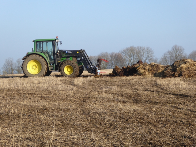
Ovington is surrounded by natural beauty, making it an attractive destination for outdoor enthusiasts. The nearby Northumberland National Park offers stunning landscapes, including rolling hills, woodlands, and expansive moorlands. The park provides numerous opportunities for walking, hiking, and wildlife spotting.

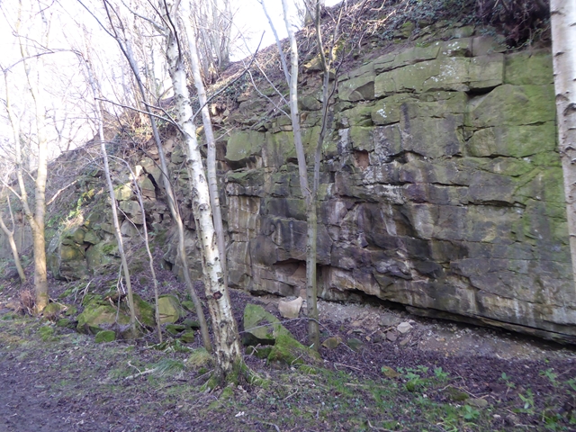
Historically, Ovington has a rich heritage, with evidence of human settlement dating back to Roman times. The area boasts several archaeological sites, including the remains of Roman forts and a medieval motte-and-bailey castle. These historical landmarks attract visitors interested in exploring the region's past.

Overall, Ovington is a tranquil and picturesque civil parish in Northumberland, offering a peaceful lifestyle surrounded by natural beauty and a strong sense of community.

If you have any feedback on the listing, please let us know in the comments section below.

Ovington Images

Images are sourced within 2km of 54.97062/-1.891742 or Grid Reference NZ0764. Thanks to Geograph Open Source API. All images are credited.

Ovingham Bridge Vital refurbishment work began on Ovingham Bridge in March 2014 <a href="https://www.geograph.org.uk/photo/4183039">NZ0863 : Refurbishment of Ovingham Bridge</a> It was re-opened to traffic 18 months later, on 3rd December 2015.

The River Tyne reached unprecedented levels on 5-6 December 2015 caused by Storm Desmond. Flood debris was caught by the bridge scaffolding and due to the high volume and speed of water pushing against it, the scaffolding was displaced downstream, much of it onto the supports of the adjacent footbridge.

The footbridge was closed to pedestrians as it was not designed to carry them and the weight of the scaffold. The road bridge was closed to vehicles for safety reasons until river levels drop and the foundations can be inspected to assess any damage. It is currently open for pedestrians and cyclists only.
Ovingham Bridge
Vital refurbishment work began on Ovingham Bridge in March 2014 NZ0863 : Refurbishment of Ovingham Bridge It was re-opened to traffic 18 months later, on 3rd December 2015. The River Tyne reached unprecedented levels on 5-6 December 2015 caused by Storm Desmond. Flood debris was caught by the bridge scaffolding and due to the high volume and speed of water pushing against it, the scaffolding was displaced downstream, much of it onto the supports of the adjacent footbridge. The footbridge was closed to pedestrians as it was not designed to carry them and the weight of the scaffold. The road bridge was closed to vehicles for safety reasons until river levels drop and the foundations can be inspected to assess any damage. It is currently open for pedestrians and cyclists only.
Steps & footbridge, Whittle Dene Whittle Dene is a wooded stream valley through which runs the Whittle Burn to join the River Tyne at Ovingham. Parts of Whittle Dene (or 'Dean' on old maps) consists of semi-natural, ancient woodland, continuously wooded since at least 1600. The long history has allowed a rich assembly of plants and a varied animal life to develop. Coppicing has been recently renewed and allows more light to penetrate the tree canopy, improving the habitat for wildlife.
The Dene has an industrial past. At the southern end of the wood are the remains of a mill pond, a well, weir and derelict buildings – all that’s left of a water-driven flour-mill. The millpond has since become an overgrown carr, colonised by willow and alder, often with a colourful display of opposite-leaved golden saxifrage.
At the southern end, there are several, privately-owned wooden chalets, summer houses with a woodland and stream-side setting.
The northern part of the wood is managed by the Woodland Trust <span class="nowrap"><a title="http://www.woodlandtrust.org.uk/en/our-woods/Pages/wood-details.aspx?wood=4413" rel="nofollow ugc noopener" href="http://www.woodlandtrust.org.uk/en/our-woods/Pages/wood-details.aspx?wood=4413">Link</a><img style="margin-left:2px;" alt="External link" title="External link - shift click to open in new window" src="https://s1.geograph.org.uk/img/external.png" width="10" height="10"/></span>
Whittle Dean by Graham Harvey: <span class="nowrap"><a title="https://web.archive.org/web/20150310004915/http://www.grahamharvey.org/whittle%20dean.htm" rel="nofollow ugc noopener" href="https://web.archive.org/web/20150310004915/http://www.grahamharvey.org/whittle%20dean.htm">Archive Link</a><img style="margin-left:2px;" alt="External link" title="External link - shift click to open in new window" src="https://s1.geograph.org.uk/img/external.png" width="10" height="10"/></span>
Northumberland HER: <span class="nowrap"><a title="https://archaeologydataservice.ac.uk/archsearch/record?titleId=964219" rel="nofollow ugc noopener" href="https://archaeologydataservice.ac.uk/archsearch/record?titleId=964219">Link</a><img style="margin-left:2px;" alt="External link" title="External link - shift click to open in new window" src="https://s1.geograph.org.uk/img/external.png" width="10" height="10"/></span>
North East Mills: <span class="nowrap"><a title="https://northeastmills.wordpress.com/mill-research/whittle-mill/" rel="nofollow ugc noopener" href="https://northeastmills.wordpress.com/mill-research/whittle-mill/">Link</a><img style="margin-left:2px;" alt="External link" title="External link - shift click to open in new window" src="https://s1.geograph.org.uk/img/external.png" width="10" height="10"/></span>
Steps & footbridge, Whittle Dene
Whittle Dene is a wooded stream valley through which runs the Whittle Burn to join the River Tyne at Ovingham. Parts of Whittle Dene (or 'Dean' on old maps) consists of semi-natural, ancient woodland, continuously wooded since at least 1600. The long history has allowed a rich assembly of plants and a varied animal life to develop. Coppicing has been recently renewed and allows more light to penetrate the tree canopy, improving the habitat for wildlife. The Dene has an industrial past. At the southern end of the wood are the remains of a mill pond, a well, weir and derelict buildings – all that’s left of a water-driven flour-mill. The millpond has since become an overgrown carr, colonised by willow and alder, often with a colourful display of opposite-leaved golden saxifrage. At the southern end, there are several, privately-owned wooden chalets, summer houses with a woodland and stream-side setting. The northern part of the wood is managed by the Woodland Trust LinkExternal link Whittle Dean by Graham Harvey: Archive LinkExternal link Northumberland HER: LinkExternal link North East Mills: LinkExternal link
Path by Whittle Burn Whittle Dene is a wooded stream valley through which runs the Whittle Burn to join the River Tyne at Ovingham. Parts of Whittle Dene (or 'Dean' on old maps) consists of semi-natural, ancient woodland, continuously wooded since at least 1600. The long history has allowed a rich assembly of plants and a varied animal life to develop. Coppicing has been recently renewed and allows more light to penetrate the tree canopy, improving the habitat for wildlife.
The Dene has an industrial past. At the southern end of the wood are the remains of a mill pond, a well, weir and derelict buildings – all that’s left of a water-driven flour-mill. The millpond has since become an overgrown carr, colonised by willow and alder, often with a colourful display of opposite-leaved golden saxifrage.
At the southern end, there are several, privately-owned wooden chalets, summer houses with a woodland and stream-side setting.
The northern part of the wood is managed by the Woodland Trust <span class="nowrap"><a title="http://www.woodlandtrust.org.uk/en/our-woods/Pages/wood-details.aspx?wood=4413" rel="nofollow ugc noopener" href="http://www.woodlandtrust.org.uk/en/our-woods/Pages/wood-details.aspx?wood=4413">Link</a><img style="margin-left:2px;" alt="External link" title="External link - shift click to open in new window" src="https://s1.geograph.org.uk/img/external.png" width="10" height="10"/></span>
Whittle Dean by Graham Harvey: <span class="nowrap"><a title="https://web.archive.org/web/20150310004915/http://www.grahamharvey.org/whittle%20dean.htm" rel="nofollow ugc noopener" href="https://web.archive.org/web/20150310004915/http://www.grahamharvey.org/whittle%20dean.htm">Archive Link</a><img style="margin-left:2px;" alt="External link" title="External link - shift click to open in new window" src="https://s1.geograph.org.uk/img/external.png" width="10" height="10"/></span>
Northumberland HER: <span class="nowrap"><a title="https://archaeologydataservice.ac.uk/archsearch/record?titleId=964219" rel="nofollow ugc noopener" href="https://archaeologydataservice.ac.uk/archsearch/record?titleId=964219">Link</a><img style="margin-left:2px;" alt="External link" title="External link - shift click to open in new window" src="https://s1.geograph.org.uk/img/external.png" width="10" height="10"/></span>
North East Mills: <span class="nowrap"><a title="https://northeastmills.wordpress.com/mill-research/whittle-mill/" rel="nofollow ugc noopener" href="https://northeastmills.wordpress.com/mill-research/whittle-mill/">Link</a><img style="margin-left:2px;" alt="External link" title="External link - shift click to open in new window" src="https://s1.geograph.org.uk/img/external.png" width="10" height="10"/></span>
Path by Whittle Burn
Whittle Dene is a wooded stream valley through which runs the Whittle Burn to join the River Tyne at Ovingham. Parts of Whittle Dene (or 'Dean' on old maps) consists of semi-natural, ancient woodland, continuously wooded since at least 1600. The long history has allowed a rich assembly of plants and a varied animal life to develop. Coppicing has been recently renewed and allows more light to penetrate the tree canopy, improving the habitat for wildlife. The Dene has an industrial past. At the southern end of the wood are the remains of a mill pond, a well, weir and derelict buildings – all that’s left of a water-driven flour-mill. The millpond has since become an overgrown carr, colonised by willow and alder, often with a colourful display of opposite-leaved golden saxifrage. At the southern end, there are several, privately-owned wooden chalets, summer houses with a woodland and stream-side setting. The northern part of the wood is managed by the Woodland Trust LinkExternal link Whittle Dean by Graham Harvey: Archive LinkExternal link Northumberland HER: LinkExternal link North East Mills: LinkExternal link
Prudhoe Station Level crossing and road from Ovingham bridge to the crossing
Ovingham bridge during repair
Prudhoe railway station, Northumberland Opened in 1835 by the Newcastle & Carlisle Railway, later part of the North Eastern Railway. 
View north east towards Wylam and Newcastle, through the typically North Eastern Railway footbridge.
Prudhoe railway station, Northumberland
Opened in 1835 by the Newcastle & Carlisle Railway, later part of the North Eastern Railway. View north east towards Wylam and Newcastle, through the typically North Eastern Railway footbridge.
Long shadows on the path above Whittle Dene Whittle Dene is an exceptionally deep steep-sided and well-wooded valley managed by the Woodland Trust.
Long shadows on the path above Whittle Dene
Whittle Dene is an exceptionally deep steep-sided and well-wooded valley managed by the Woodland Trust.
Culvert on the path above Whittle Dene The culvelrt is simply a large section of iron pipe. Whittle Dene is an exceptionally deep steep-sided and well-wooded valley managed by the Woodland Trust.
Culvert on the path above Whittle Dene
The culvelrt is simply a large section of iron pipe. Whittle Dene is an exceptionally deep steep-sided and well-wooded valley managed by the Woodland Trust.
Path above Whittle Dene Whittle Dene is an exceptionally deep steep-sided and well-wooded valley managed by the Woodland Trust.
Path above Whittle Dene
Whittle Dene is an exceptionally deep steep-sided and well-wooded valley managed by the Woodland Trust.
Rock face above Whittle Dene Whittle Dene is an exceptionally deep steep-sided and well-wooded valley managed by the Woodland Trust.
Rock face above Whittle Dene
Whittle Dene is an exceptionally deep steep-sided and well-wooded valley managed by the Woodland Trust.
Driveway from Whittle Farm joins the A69 The only road connection to Whittle Farm is via the dual carriageway A69. A private bridge allows access to and from the far, eastbound carriageway.
Driveway from Whittle Farm joins the A69
The only road connection to Whittle Farm is via the dual carriageway A69. A private bridge allows access to and from the far, eastbound carriageway.
A trailer full of muck At Whittle Farm.
A trailer full of muck
At Whittle Farm.
Tractor fork lift at Whittle Farm Having filled his trailer, the operator <a href="https://www.geograph.org.uk/photo/5261487">NZ0765 : A trailer full of muck</a> over to the other tractor to shift the load of manure (see <a href="https://www.geograph.org.uk/photo/5261487">NZ0765 : A trailer full of muck</a>).
Tractor fork lift at Whittle Farm
Having filled his trailer, the operator NZ0765 : A trailer full of muck over to the other tractor to shift the load of manure (see NZ0765 : A trailer full of muck).
Whittle Farm Farm on the south side of the A69. Also a mobile phone mast, believed to be Vodafone.
Whittle Farm
Farm on the south side of the A69. Also a mobile phone mast, believed to be Vodafone.
Ovingham Bridge This rickety structure, worthy of Heath Robinson, was constructed over the River Tyne in 1883. A parallel footbridge, no less rickety, was added in 1974. Patently inadequate for modern traffic, nevertheless the bridge was closed in June 2014 for 18 months for a £3 million refurbishment program. Almost immediately after reopening, it was closed by severe flooding for a further 9 months for repairs costing a further 1.4 million. Surely this sticking plaster solution is a case of throwing good money after bad.

The small lozenge-shaped widening in the middle of the bridge is a passing place (sort of).

The level crossing at Prudhoe Station lies just beyond the far end of the bridge.
Ovingham Bridge
This rickety structure, worthy of Heath Robinson, was constructed over the River Tyne in 1883. A parallel footbridge, no less rickety, was added in 1974. Patently inadequate for modern traffic, nevertheless the bridge was closed in June 2014 for 18 months for a £3 million refurbishment program. Almost immediately after reopening, it was closed by severe flooding for a further 9 months for repairs costing a further 1.4 million. Surely this sticking plaster solution is a case of throwing good money after bad. The small lozenge-shaped widening in the middle of the bridge is a passing place (sort of). The level crossing at Prudhoe Station lies just beyond the far end of the bridge.
Ovingham foot bridge This footbridge constructed in 1974 closely parallels the much older road bridge over the Tyne.

The ancient Ovingham parish church can be seen beyond the bridge.
Ovingham foot bridge
This footbridge constructed in 1974 closely parallels the much older road bridge over the Tyne. The ancient Ovingham parish church can be seen beyond the bridge.
Ovingham Bridge The elegant iron trestles support the 19th century Ovingham Bridge over the River Tyne,  a fine example of Victorian engineering perhaps, but totally inadequate to cope with 21st century traffic. The even more spindly legs beyond support the parallel footbridge added in 1974.
Ovingham Bridge
The elegant iron trestles support the 19th century Ovingham Bridge over the River Tyne, a fine example of Victorian engineering perhaps, but totally inadequate to cope with 21st century traffic. The even more spindly legs beyond support the parallel footbridge added in 1974.
The bridges at Ovingham To the left, the road bridge over the River Tyne, built in 1883 and completely inadequate to cope with 21st century traffic; to the right the footbridge which was added in 1974,
The bridges at Ovingham
To the left, the road bridge over the River Tyne, built in 1883 and completely inadequate to cope with 21st century traffic; to the right the footbridge which was added in 1974,
Show me another place!

Ovington is located at Grid Ref: NZ0764 (Lat: 54.97062, Lng: -1.891742)

Unitary Authority: Northumberland

Police Authority: Northumbria

What 3 Words

///undertook.roofer.incur. Near Prudhoe, Northumberland

Nearby Locations

Whittle Dene Ovington

Related Wikis

Ovington, Northumberland

Ovington is a village and civil parish in the south of Northumberland, England. It is located on the north bank of the River Tyne. == History == Very...

Cherryburn

Cherryburn is a cottage in Mickley, Northumberland, England. It was the birthplace of Thomas Bewick, an English wood engraver and ornithologist. The cottage...
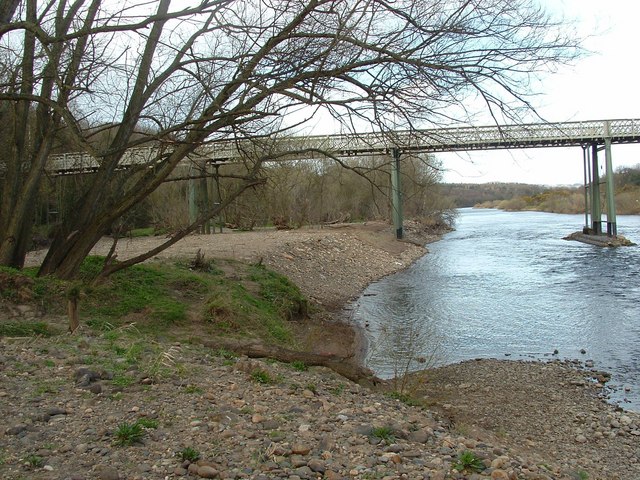
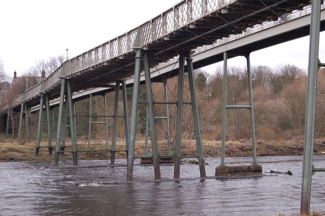
Ovingham Bridge

Ovingham Bridges are a pair of side-by-side vehicle and pedestrian bridges across the River Tyne linking Ovingham and Prudhoe in Northumberland, England...

Ovingham

Ovingham is a civil parish and village in the Tyne Valley of south Northumberland, England. It lies on the River Tyne 10 miles (16 km) east of Hexham...

Nearby Amenities

Located within 500m of 54.97062,-1.891742
Ovington
Place: village
Source: npe
Lat/Long: 54.9688511/-1.8979777
Ovington House
Tourism: guest_house
Website: https://www.ovingtonhouse.co.uk/
Lat/Long: 54.9684549/-1.8946245
Restaurant
Winships
Addr City: Ovington
Addr County: Northumberland
Addr Postcode: NE42 6DH
Addr Street: Main Road
Cuisine: regional
Fhrs Id: 287146
Source: Local knowledge
Lat/Long: 54.9684255/-1.8962843
Pub
Ovington Social Club
Addr City: Ovington
Addr County: Northumberland
Addr Postcode: NE42 6DH
Addr Street: Dene View
Fhrs Id: 287051
Lat/Long: 54.968865/-1.8955168
Telephone
Village Information
Booth: K6
Covered: booth
Man Made: telephone_box
Tourism: information
Lat/Long: 54.9684505/-1.8966418
Post Box
Collection Times: Mo-Fr 17:00; Sa 11:30
Drive Through: no
Operator: Royal Mail
Operator Wikidata: Q638098
Post Box Type: pillar
Ref: NE42 505
Royal Cypher: EIIR
Royal Cypher Wikidata: Q33102113
Lat/Long: 54.9680958/-1.8979124
Direction: SSE
Generator Method: photovoltaic
Generator Output Electricity: yes
Generator Source: solar
Generator Type: solar_photovoltaic_panel
Location: roof
Power: generator
Lat/Long: 54.9693255/-1.8978333
Direction: SSE
Generator Method: photovoltaic
Generator Output Electricity: yes
Generator Source: solar
Generator Type: solar_photovoltaic_panel
Location: roof
Power: generator
Lat/Long: 54.9699013/-1.8987748
Direction: SSE
Generator Method: photovoltaic
Generator Output Electricity: yes
Generator Source: solar
Generator Type: solar_photovoltaic_panel
Location: roof
Power: generator
Lat/Long: 54.9683124/-1.8981686
Direction: SSE
Generator Method: photovoltaic
Generator Output Electricity: yes
Generator Source: solar
Generator Type: solar_photovoltaic_panel
Location: roof
Power: generator
Lat/Long: 54.9694453/-1.897384
Direction: SSE
Generator Method: photovoltaic
Generator Output Electricity: yes
Generator Source: solar
Generator Type: solar_photovoltaic_panel
Location: roof
Power: generator
Lat/Long: 54.9685226/-1.8972821
Direction: WSW
Generator Method: photovoltaic
Generator Output Electricity: yes
Generator Source: solar
Generator Type: solar_photovoltaic_panel
Location: roof
Power: generator
Lat/Long: 54.9675854/-1.8972419
Direction: ENE
Generator Method: photovoltaic
Generator Output Electricity: yes
Generator Source: solar
Generator Type: solar_photovoltaic_panel
Location: roof
Power: generator
Lat/Long: 54.9675961/-1.8971909
Generator Method: photovoltaic
Generator Output Electricity: yes
Generator Source: solar
Generator Type: solar_photovoltaic_panel
Location: roof
Power: generator
Lat/Long: 54.9679256/-1.8967005
Generator Method: photovoltaic
Generator Output Electricity: yes
Generator Source: solar
Generator Type: solar_photovoltaic_panel
Location: roof
Power: generator
Lat/Long: 54.9693626/-1.8987511
Defibrillator
Defibrillator Location: Ovington
Emergency: defibrillator
Indoor: no
Lat/Long: 54.9682606/-1.8973435
Bus Stop
Ovington, Hunters Lodge
Bench: no
Bus: yes
Departures Board: timetable
Naptan AtcoCode: 3100Z066638
Naptan NaptanCode: nldgmgtp
Public Transport: platform
Shelter: no
Lat/Long: 54.968145/-1.8979162
Bus Stop
Ovington, Hunters Lodge
Bus: yes
Departures Board: timetable
Public Transport: platform
Shelter: yes
Lat/Long: 54.968552/-1.8967738
The data included in this document is from www.openstreetmap.org. The data is made available under ODbL.

Have you been to Ovington?

Leave your review of Ovington below (or comments, questions and feedback).