Newton and Haceby

Civil Parish in Lincolnshire North Kesteven

England

Newton and Haceby

Haceby: aerial 2021 (1)
Haceby: aerial 2021 (1) Credit: Chris

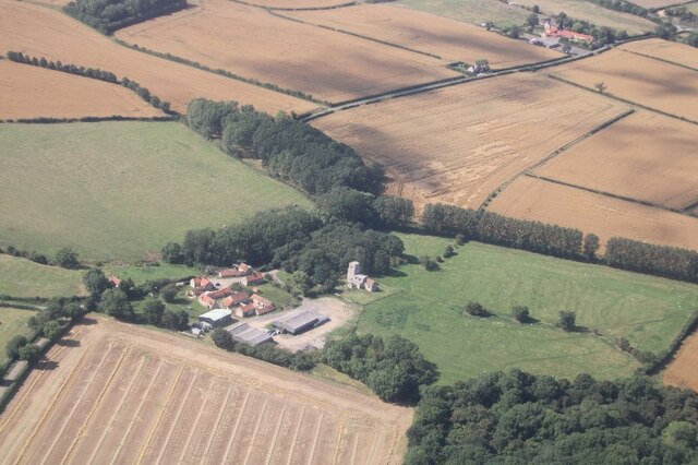
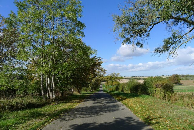
Newton and Haceby is a civil parish located in the county of Lincolnshire, England. Situated approximately 11 miles south of the city of Lincoln, the parish encompasses the two small villages of Newton and Haceby.

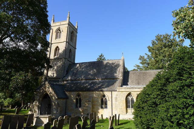
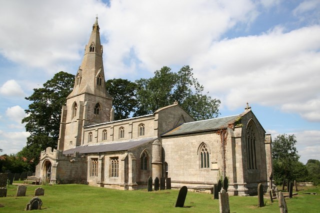
The area is known for its picturesque charm, with both villages boasting a quaint and tranquil atmosphere. Newton, the larger of the two villages, is characterized by its traditional stone cottages and well-manicured gardens. It is home to a small but close-knit community, with a population of around 200 residents. The village features a historic church, St. Botolph's Church, which dates back to the 13th century and is known for its impressive architecture.

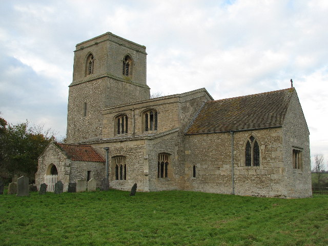
Haceby, on the other hand, is a smaller village with a population of around 50 residents. It is located about 1 mile northeast of Newton and is surrounded by beautiful countryside. The village is notable for its Grade II listed Haceby Hall, a stunning Georgian country house that adds to the area's historical appeal.

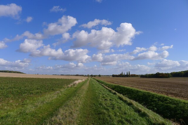
Both Newton and Haceby offer a serene and idyllic lifestyle, with residents enjoying a peaceful rural setting. The surrounding countryside provides ample opportunities for outdoor activities such as walking, cycling, and horse riding. The nearby city of Lincoln offers easy access to amenities, including shops, schools, and healthcare facilities.

Overall, Newton and Haceby in Lincolnshire are charming rural villages that provide a tranquil retreat for residents seeking a slower pace of life within close proximity to larger towns and cities.

If you have any feedback on the listing, please let us know in the comments section below.

Newton and Haceby Images

Images are sourced within 2km of 52.914343/-0.449436 or Grid Reference TF0436. Thanks to Geograph Open Source API. All images are credited.

Haceby: aerial 2021 (1)
Haceby: aerial 2021 (2)
Church of St Andrew, Scott Willoughby "10th century parish church with alterations or additions in the 12th and 17th centuries, repaired 1826, chancel renewed 1826, walls restored 1882" <span class="nowrap"><a title="https://heritage-explorer.lincolnshire.gov.uk/Monument/MLI90870" rel="nofollow ugc noopener" href="https://heritage-explorer.lincolnshire.gov.uk/Monument/MLI90870">Link</a><img style="margin-left:2px;" alt="External link" title="External link - shift click to open in new window" src="https://s1.geograph.org.uk/img/external.png" width="10" height="10"/></span>
"The smallest church still in use in the county of Lincolnshire" <span class="nowrap"><a title="https://www.parishofsouthlafford.org/scott-willoughby-st-andrew-s-church" rel="nofollow ugc noopener" href="https://www.parishofsouthlafford.org/scott-willoughby-st-andrew-s-church">Link</a><img style="margin-left:2px;" alt="External link" title="External link - shift click to open in new window" src="https://s1.geograph.org.uk/img/external.png" width="10" height="10"/></span>
Church of St Andrew, Scott Willoughby
"10th century parish church with alterations or additions in the 12th and 17th centuries, repaired 1826, chancel renewed 1826, walls restored 1882" LinkExternal link "The smallest church still in use in the county of Lincolnshire" LinkExternal link
Crossway, north of Scott Willoughby Willoughby Road from Osbournby (right) bends 90 degrees towards Scott Willoughby (lower left). A restricted byway carries straight on to Dembleby (upper left). A bridleway climbs the slope to Aunsby (upper right).
Crossway, north of Scott Willoughby
Willoughby Road from Osbournby (right) bends 90 degrees towards Scott Willoughby (lower left). A restricted byway carries straight on to Dembleby (upper left). A bridleway climbs the slope to Aunsby (upper right).
Restricted byway from Dembleby towards Osbournby The byway forms part of a line of quiet roads, byways and bridleways forming an east-west cycling route avoiding the dangerous A52
Restricted byway from Dembleby towards Osbournby
The byway forms part of a line of quiet roads, byways and bridleways forming an east-west cycling route avoiding the dangerous A52
Newton Bar, A52 Location of one of the turnpikes (barrier gates) when the A52 was maintained as a toll road <span class="nowrap"><a title="https://www.sabre-roads.org.uk/wiki/index.php?title=Lincolnshire_Turnpikes" rel="nofollow ugc noopener" href="https://www.sabre-roads.org.uk/wiki/index.php?title=Lincolnshire_Turnpikes">Link</a><img style="margin-left:2px;" alt="External link" title="External link - shift click to open in new window" src="https://s1.geograph.org.uk/img/external.png" width="10" height="10"/></span>
Newton Bar, A52
Location of one of the turnpikes (barrier gates) when the A52 was maintained as a toll road LinkExternal link
Road from Newton down to Newton Bar (A52) Running down to one of the shallow valleys formed by tributaries to the South Forty Drain Catchment
Road from Newton down to Newton Bar (A52)
Running down to one of the shallow valleys formed by tributaries to the South Forty Drain Catchment
Village Cross, The Green, Newton Listed Grade II 'buildings': a 19th century cross and, behind, the late 18th century Laundry Cottage <span class="nowrap"><a title="https://historicengland.org.uk/listing/the-list/map-search?clearresults=true?clearresults=True#?search=TF04723626" rel="nofollow ugc noopener" href="https://historicengland.org.uk/listing/the-list/map-search?clearresults=true?clearresults=True#?search=TF04723626">Link</a><img style="margin-left:2px;" alt="External link" title="External link - shift click to open in new window" src="https://s1.geograph.org.uk/img/external.png" width="10" height="10"/></span>
Village Cross, The Green, Newton
Listed Grade II 'buildings': a 19th century cross and, behind, the late 18th century Laundry Cottage LinkExternal link
Church of St Botolph, Newton Listed Grade I. Built 13th to 15th, and restored 19th century <span class="nowrap"><a title="https://historicengland.org.uk/listing/the-list/list-entry/1061795?section=official-list-entry" rel="nofollow ugc noopener" href="https://historicengland.org.uk/listing/the-list/list-entry/1061795?section=official-list-entry">Link</a><img style="margin-left:2px;" alt="External link" title="External link - shift click to open in new window" src="https://s1.geograph.org.uk/img/external.png" width="10" height="10"/></span>
Church of St Botolph, Newton
Listed Grade I. Built 13th to 15th, and restored 19th century LinkExternal link
Restricted byway running due east from Newton Heading towards Horse Close Plantation
Restricted byway running due east from Newton
Heading towards Horse Close Plantation
Saint Botolphs Church, Newton by Folkingham.
Haceby Little Wood
Haceby Little Wood
Haceby Church, Dedicated To The Saints Margaret & Barbara First time I have come across a church dedicated to Saint Barbara. Albeit shared with Saint Margaret.
Haceby Church, Dedicated To The Saints Margaret & Barbara
First time I have come across a church dedicated to Saint Barbara. Albeit shared with Saint Margaret.
Saint Lucia's Church, Dembleby
Interior of Haceby Church St Margaret's Church, sometimes known as St Barbara's, in Haceby has a fine painted decoration on the chancel arch. It shows the arms of Queen Anne which was restored in 1979. It was painted over a Medieval "Doom" and you can still make out angels herding a crowd of sinners onto the path to Hell on the right hand side. See <span class="nowrap"><a title="http://homepages.which.net/~rex/bourne/haceby.htm" rel="nofollow ugc noopener" href="http://homepages.which.net/~rex/bourne/haceby.htm">Link</a><img style="margin-left:2px;" alt="External link" title="External link - shift click to open in new window" src="https://s1.geograph.org.uk/img/external.png" width="10" height="10"/></span> for further information about the village and church although the site is open and the church easy to access now. It is managed by the Churches Conservation Trust and there is an informative leaflet available by the font. <span class="nowrap"><a title="http://www.visitchurches.org.uk/frontpage.asp" rel="nofollow ugc noopener" href="http://www.visitchurches.org.uk/frontpage.asp">Link</a><img style="margin-left:2px;" alt="External link" title="External link - shift click to open in new window" src="https://s1.geograph.org.uk/img/external.png" width="10" height="10"/></span> for info about the CCT.
Interior of Haceby Church
St Margaret's Church, sometimes known as St Barbara's, in Haceby has a fine painted decoration on the chancel arch. It shows the arms of Queen Anne which was restored in 1979. It was painted over a Medieval "Doom" and you can still make out angels herding a crowd of sinners onto the path to Hell on the right hand side. See LinkExternal link for further information about the village and church although the site is open and the church easy to access now. It is managed by the Churches Conservation Trust and there is an informative leaflet available by the font. LinkExternal link for info about the CCT.
Little Haceby Wood, Lincolnshire View towards the wood across St Margaret's church yard through the porch window.
Little Haceby Wood, Lincolnshire
View towards the wood across St Margaret's church yard through the porch window.
Country Road at Haceby, Lincolnshire A small stone and pantile barn on the lane leading out of Haceby towards the A52.
Country Road at Haceby, Lincolnshire
A small stone and pantile barn on the lane leading out of Haceby towards the A52.
Haceby, Lincolnshire See <span class="nowrap"><a title="http://homepages.which.net/~rex/bourne/haceby.htm" rel="nofollow ugc noopener" href="http://homepages.which.net/~rex/bourne/haceby.htm">Link</a><img style="margin-left:2px;" alt="External link" title="External link - shift click to open in new window" src="https://s1.geograph.org.uk/img/external.png" width="10" height="10"/></span> for information but note that several houses have now been renovated and are lived in once more.
Haceby, Lincolnshire
See LinkExternal link for information but note that several houses have now been renovated and are lived in once more.
Show me another place!

Newton and Haceby is located at Grid Ref: TF0436 (Lat: 52.914343, Lng: -0.449436)

Administrative County: Lincolnshire

District: North Kesteven

Police Authority: Lincolnshire

What 3 Words

///starch.magnitude.trombone. Near Billingborough, Lincolnshire

Related Wikis

Newton, Lincolnshire

Newton is a hamlet in the North Kesteven district of Lincolnshire, England. The hamlet is situated approximately 8 miles (13 km) east from the town of...

Newton and Haceby

Newton and Haceby is a civil parish in North Kesteven, Lincolnshire, England. It includes the separate hamlets of Newton and Haceby. The population of...

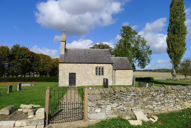
St Barbara's Church, Haceby

St Barbara's Church is a redundant Anglican church in the village of Haceby, Lincolnshire, England. It is recorded in the National Heritage List for England...

Haceby

Haceby is a hamlet in the civil parish of Newton and Haceby in the district of North Kesteven, Lincolnshire, England. It is 8 miles (13 km) east from...

Walcot, Lincolnshire

Walcot is a village and civil parish in the North Kesteven district of Lincolnshire, England. It lies 1 mile (1.6 km) west from the A15, 7 miles (11 km...

Threekingham Bar

Threekingham Bar is the name given to interception of the A52 (Grantham to Boston) and A15 (Peterborough to Lincoln and Hull) roads, 1 mile (1.6 km) to...

Pickworth, Lincolnshire

Pickworth is a village and civil parish in the South Kesteven district of Lincolnshire, England. The population of the civil parish including Braceby and...

Braceby

Braceby is a small English village in the South Kesteven district of Lincolnshire. Its population is included in the civil parish of Pickworth. The village...

Nearby Amenities

Located within 500m of 52.914343,-0.449436
Newton
Place: village
Wikidata: Q11790934
Wikipedia: en:Newton, Lincolnshire
Lat/Long: 52.9135661/-0.4444255
Bus Stop
Red Lion PH
Naptan AtcoCode: 2700LNRL1893
Naptan Bearing: NW
Naptan CommonName: Red Lion PH
Naptan Indicator: adj
Naptan Landmark: Red Lion PH
Naptan NaptanCode: linamwdg
Naptan Street: Main Street
Naptan Verified: no
Source: naptan_import
Lat/Long: 52.912294/-0.4475821
Woodside Farm
Place: farm
Source: Bing
Lat/Long: 52.9126171/-0.4490561
The data included in this document is from www.openstreetmap.org. The data is made available under ODbL.

Have you been to Newton and Haceby?

Leave your review of Newton and Haceby below (or comments, questions and feedback).