Lindsey

Civil Parish in Suffolk Babergh

England

Lindsey

Footpath at Kersey
Footpath at Kersey Credit: Jonathan Thacker

Lindsey is a civil parish located in the county of Suffolk, England. It is situated in the Waveney district and covers an area of approximately 9 square kilometers. The parish is located about 5 miles west of Beccles and is surrounded by picturesque countryside.

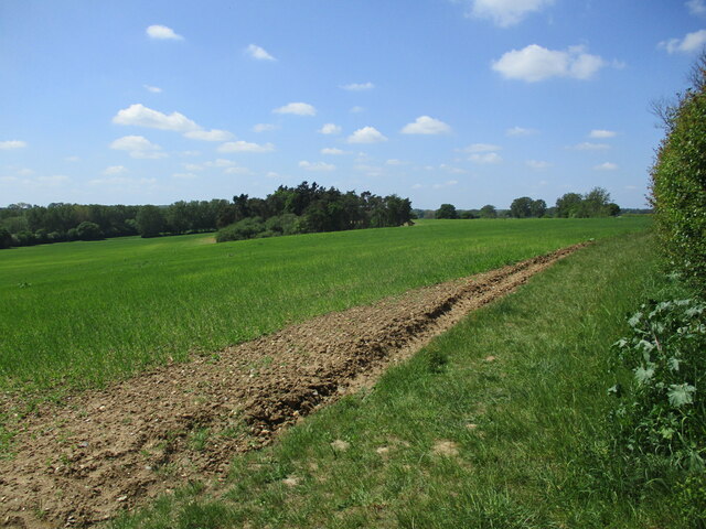
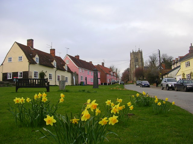
The village of Lindsey itself is small and charming, with a population of around 300 people. It is a predominantly rural area, with lush green fields and rolling hills surrounding the village. The landscape is dotted with traditional English cottages and farmhouses, adding to the area's idyllic charm.

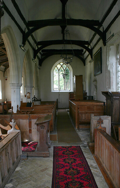
Despite its small size, Lindsey has a strong sense of community. The village is home to a number of local amenities, including a village hall, a primary school, a church, and a pub. These facilities provide a focal point for residents to come together and participate in various community activities and events.

The parish of Lindsey is also known for its agricultural heritage. The fertile soil and favorable climate make it an ideal location for farming, and the area is dotted with farms and agricultural businesses. This agricultural activity not only contributes to the local economy but also adds to the rural character of the parish.

Overall, Lindsey is a peaceful and picturesque civil parish that offers a tranquil escape from the hustle and bustle of urban life. Its close-knit community, beautiful countryside, and agricultural traditions make it a unique and charming destination in Suffolk.

If you have any feedback on the listing, please let us know in the comments section below.

Lindsey Images

Images are sourced within 2km of 52.068861/0.888722 or Grid Reference TL9845. Thanks to Geograph Open Source API. All images are credited.

Footpath at Kersey
Footpath at Kersey
Barley field and plantation, Kersey
Mini-valley near Lindsey One of many small valleys in the area created by the streams that eventually flow into the river Brett. Although watercourse seen here appeared to be dried out today, it is one of several that feed the watersplash at Kersey further downstream.
Mini-valley near Lindsey
One of many small valleys in the area created by the streams that eventually flow into the river Brett. Although watercourse seen here appeared to be dried out today, it is one of several that feed the watersplash at Kersey further downstream.
Houses in Church Road, Lindsey Taken from just south of St Peter's church.
Houses in Church Road, Lindsey
Taken from just south of St Peter's church.
View east from Church Road, Lindsey Shows scenery typical of this part of Suffolk with undulating arable fields dotted with woodlands and incised by small valleys.
View east from Church Road, Lindsey
Shows scenery typical of this part of Suffolk with undulating arable fields dotted with woodlands and incised by small valleys.
St Peter, Lindsey - interior looking west Most of the church dates from the early C14 and remains unspoiled by subsequent modernisation.
St Peter, Lindsey - interior looking west
Most of the church dates from the early C14 and remains unspoiled by subsequent modernisation.
St Peter, Lindsey - interior looking east Most of the church dates from the early C14 and remains unspoiled by subsequent modernisation.
St Peter, Lindsey - interior looking east
Most of the church dates from the early C14 and remains unspoiled by subsequent modernisation.
St Peter, Lindsey - south-eastern elevation Most of the church dates from the early C14 and remains unspoiled by subsequent modernisation. The west tower was removed in 1836 and replaced with a weather-boarded turret.
St Peter, Lindsey - south-eastern elevation
Most of the church dates from the early C14 and remains unspoiled by subsequent modernisation. The west tower was removed in 1836 and replaced with a weather-boarded turret.
St Peter, Lindsey - north-eastern elevation Most of the church dates from the early C14 and remains unspoiled by subsequent modernisation. The west tower was removed in 1836 and replaced with a weather-boarded turret.
St Peter, Lindsey - north-eastern elevation
Most of the church dates from the early C14 and remains unspoiled by subsequent modernisation. The west tower was removed in 1836 and replaced with a weather-boarded turret.
Suffolk countryside west of Kersey
Lindsey Tye: Clay Hill
Chelsworth: Clay Hill
Lindsey Tye: Ploughed field
Semer: 'Threeways'
Semer: 'Threeways'
Semer Gate Farm: Harvested crop
Path in Groton Wood Groton Wood Nature Reserve is an SSSI managed by the Suffolk Wildlife Trust. They say on their website: <span class="nowrap"><a title="https://www.suffolkwildlifetrust.org/grotonwood" rel="nofollow ugc noopener" href="https://www.suffolkwildlifetrust.org/grotonwood">Link</a><img style="margin-left:2px;" alt="External link" title="External link - shift click to open in new window" src="https://s1.geograph.org.uk/img/external.png" width="10" height="10"/></span> :

"Brimstone butterflies feed on sunny spring days and woodcock display at dusk. This ancient woodland is noted for its small-leaved lime coppice, this is an indication that the northern part of the wood has existed since prehistoric times. The other species to note in Groton Woods is its large wild cherry trees, -it is one of only a few ancient woodlands in Suffolk with this species.

Groton Wood is unusual in that is has 22 seasonal ponds. These are good places to spot frog, toad and newt including the protected great-crested newt.

The rides are bursting with bluebell, pignut and early-purple orchid with shadier areas being characterised by violet helleborine, woodruff and herb-paris. 15 species of butterfly have been recorded at Groton Wood including brimstone, speckled wood and purple hairstreak whose caterpillars feed on oak. Summer songsters include black cap, willow warbler and chiffchaff, while other birds such as treecreeper, all three woodpecker species, woodcock and nuthatch are resident here."
Path in Groton Wood
Groton Wood Nature Reserve is an SSSI managed by the Suffolk Wildlife Trust. They say on their website: LinkExternal link : "Brimstone butterflies feed on sunny spring days and woodcock display at dusk. This ancient woodland is noted for its small-leaved lime coppice, this is an indication that the northern part of the wood has existed since prehistoric times. The other species to note in Groton Woods is its large wild cherry trees, -it is one of only a few ancient woodlands in Suffolk with this species. Groton Wood is unusual in that is has 22 seasonal ponds. These are good places to spot frog, toad and newt including the protected great-crested newt. The rides are bursting with bluebell, pignut and early-purple orchid with shadier areas being characterised by violet helleborine, woodruff and herb-paris. 15 species of butterfly have been recorded at Groton Wood including brimstone, speckled wood and purple hairstreak whose caterpillars feed on oak. Summer songsters include black cap, willow warbler and chiffchaff, while other birds such as treecreeper, all three woodpecker species, woodcock and nuthatch are resident here."
Chapel of St James, Lindsey <span class="nowrap"><a title="https://historicengland.org.uk/listing/the-list/list-entry/1351517?section=official-list-entry" rel="nofollow ugc noopener" href="https://historicengland.org.uk/listing/the-list/list-entry/1351517?section=official-list-entry">Link</a><img style="margin-left:2px;" alt="External link" title="External link - shift click to open in new window" src="https://s1.geograph.org.uk/img/external.png" width="10" height="10"/></span>
Chapel of St James, Lindsey
Cottages in Kersey, Suffolk
Show me another place!

Lindsey is located at Grid Ref: TL9845 (Lat: 52.068861, Lng: 0.888722)

Administrative County: Suffolk

District: Babergh

Police Authority: Suffolk

What 3 Words

///showed.brains.tabs. Near Bildeston, Suffolk

Nearby Locations

Lindsey Lindsey Tye

Related Wikis

Lindsey, Suffolk

Lindsey is a small village and a civil parish, located in mid-to-south Suffolk, under the purview of Babergh District Council. == Layout == The parish...

Kersey Priory

Kersey Priory was a priory in Kersey, Suffolk, England. It was founded before 1218 as a hospital dedicated St Mary the Blessed Virgin and St Anthony under...

Groton Wood

Groton Wood is a 20.2-hectare (50-acre) biological Site of Special Scientific Interest north-east of Groton in Suffolk. It is owned and managed by the...

Monks Eleigh

Monks Eleigh is a village and a civil parish in Babergh, Suffolk, United Kingdom, situated on the tributary to the River Brett in a rural area. The parish...

Nearby Amenities

Located within 500m of 52.068861,0.888722
Lindsey
Place: village
Wikidata: Q1826319
Wikipedia: en:Lindsey, Suffolk
Lat/Long: 52.0676811/0.8846821
Bus Stop
Phone Box
Naptan AtcoCode: 390010343
Naptan Bearing: N
Naptan CommonName: Phone Box
Naptan Indicator: o/s
Naptan Landmark: Phone Box
Naptan NaptanCode: sufadwtw
Naptan Street: Church Road
Naptan Verified: no
Source: naptan_import
Lat/Long: 52.0677768/0.8834464
Phone Box
Naptan AtcoCode: 390010344
Naptan Bearing: SW
Naptan BusStopType: CUS
Naptan CommonName: Phone Box
Naptan Indicator: opp
Naptan Landmark: Phone Box
Naptan NaptanCode: sufagada
Naptan Street: Church Road
Naptan Verified: no
Source: naptan_import
Lat/Long: 52.0677567/0.8835326
The data included in this document is from www.openstreetmap.org. The data is made available under ODbL.

Have you been to Lindsey?

Leave your review of Lindsey below (or comments, questions and feedback).