Lilleshall

Civil Parish in Shropshire

England

Lilleshall

Lilleshall Hill farmhouse No longer a farmhouse in the sense of being associated with a working farm, but nonetheless it's a fine 18th century building, which attracted a Grade II listing <span class="nowrap"><a title="https://britishlistedbuildings.co.uk/101208242-lilleshall-hill-farmhouse-lilleshall#.YRPxz4hKjIU" rel="nofollow ugc noopener" href="https://britishlistedbuildings.co.uk/101208242-lilleshall-hill-farmhouse-lilleshall#.YRPxz4hKjIU">Link</a><img style="margin-left:2px;" alt="External link" title="External link - shift click to open in new window" src="https://s1.geograph.org.uk/img/external.png" width="10" height="10"/></span> & <span class="nowrap"><a title="https://historicengland.org.uk/listing/the-list/list-entry/1208242" rel="nofollow ugc noopener" href="https://historicengland.org.uk/listing/the-list/list-entry/1208242">Link</a><img style="margin-left:2px;" alt="External link" title="External link - shift click to open in new window" src="https://s1.geograph.org.uk/img/external.png" width="10" height="10"/></span> in 1983.
Lilleshall Hill farmhouse Credit: Richard Law

Lilleshall is a civil parish located in the county of Shropshire, England. It is situated approximately 5 miles northwest of Newport, a market town and administrative center of the area. The parish covers an area of about 1,000 acres and is home to a population of around 1,500 residents.

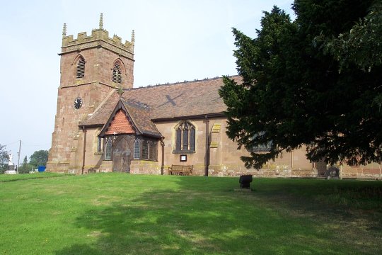
The village of Lilleshall is known for its picturesque setting, surrounded by rolling countryside and scenic landscapes. It has a rich history that dates back to the medieval period and has been mentioned in the Domesday Book of 1086. The village is characterized by its charming old buildings, including the Grade I listed St. Michael and All Angels Church, which dates back to the 12th century. The church is renowned for its beautiful stained glass windows and intricate architectural details.

Lilleshall is also famous for its sports facilities. The Lilleshall National Sports Centre, located on the outskirts of the village, is a renowned training venue for various sports, including football, gymnastics, and archery. The center has hosted numerous national and international events and has been the training ground for many elite athletes.

The village offers a range of amenities to its residents, including a primary school, a village hall, and a post office. There are also a few local shops, pubs, and restaurants, providing essential services and a sense of community.

Overall, Lilleshall is a picturesque and historic village that offers a peaceful and idyllic setting for its residents, with a strong focus on sports and community activities.

If you have any feedback on the listing, please let us know in the comments section below.

Lilleshall Images

Images are sourced within 2km of 52.740908/-2.421656 or Grid Reference SJ7116. Thanks to Geograph Open Source API. All images are credited.

Lilleshall Hill farmhouse No longer a farmhouse in the sense of being associated with a working farm, but nonetheless it's a fine 18th century building, which attracted a Grade II listing <span class="nowrap"><a title="https://britishlistedbuildings.co.uk/101208242-lilleshall-hill-farmhouse-lilleshall#.YRPxz4hKjIU" rel="nofollow ugc noopener" href="https://britishlistedbuildings.co.uk/101208242-lilleshall-hill-farmhouse-lilleshall#.YRPxz4hKjIU">Link</a><img style="margin-left:2px;" alt="External link" title="External link - shift click to open in new window" src="https://s1.geograph.org.uk/img/external.png" width="10" height="10"/></span> & <span class="nowrap"><a title="https://historicengland.org.uk/listing/the-list/list-entry/1208242" rel="nofollow ugc noopener" href="https://historicengland.org.uk/listing/the-list/list-entry/1208242">Link</a><img style="margin-left:2px;" alt="External link" title="External link - shift click to open in new window" src="https://s1.geograph.org.uk/img/external.png" width="10" height="10"/></span> in 1983.
Lilleshall Hill farmhouse
No longer a farmhouse in the sense of being associated with a working farm, but nonetheless it's a fine 18th century building, which attracted a Grade II listing LinkExternal link & LinkExternal link in 1983.
17th century barn in Lilleshall A timber-framed former farm barn and cart-shed, now converted to residential use. It dates primarily from the 17th century or thereabouts, but obviously has seen alterations over the years; it attracted a Grade II listing <span class="nowrap"><a title="https://britishlistedbuildings.co.uk/101038248-barn-immediately-north-east-of-lilleshall-hill-farmhouse-lilleshall#.YRPzQYhKjIU" rel="nofollow ugc noopener" href="https://britishlistedbuildings.co.uk/101038248-barn-immediately-north-east-of-lilleshall-hill-farmhouse-lilleshall#.YRPzQYhKjIU">Link</a><img style="margin-left:2px;" alt="External link" title="External link - shift click to open in new window" src="https://s1.geograph.org.uk/img/external.png" width="10" height="10"/></span> & <span class="nowrap"><a title="https://historicengland.org.uk/listing/the-list/list-entry/1038248" rel="nofollow ugc noopener" href="https://historicengland.org.uk/listing/the-list/list-entry/1038248">Link</a><img style="margin-left:2px;" alt="External link" title="External link - shift click to open in new window" src="https://s1.geograph.org.uk/img/external.png" width="10" height="10"/></span> in 1983.
17th century barn in Lilleshall
A timber-framed former farm barn and cart-shed, now converted to residential use. It dates primarily from the 17th century or thereabouts, but obviously has seen alterations over the years; it attracted a Grade II listing LinkExternal link & LinkExternal link in 1983.
Nos 1 & 3 The Green, Lilleshall A pair of late 17th or early 18th century timber-framed cottages; they were faced in brick in the 19th and which attracted a Grade II listing <span class="nowrap"><a title="https://britishlistedbuildings.co.uk/101208258-1-and-3-the-green-lilleshall#.YRP0kIhKjIU" rel="nofollow ugc noopener" href="https://britishlistedbuildings.co.uk/101208258-1-and-3-the-green-lilleshall#.YRP0kIhKjIU">Link</a><img style="margin-left:2px;" alt="External link" title="External link - shift click to open in new window" src="https://s1.geograph.org.uk/img/external.png" width="10" height="10"/></span> & <span class="nowrap"><a title="https://historicengland.org.uk/listing/the-list/list-entry/1208258" rel="nofollow ugc noopener" href="https://historicengland.org.uk/listing/the-list/list-entry/1208258">Link</a><img style="margin-left:2px;" alt="External link" title="External link - shift click to open in new window" src="https://s1.geograph.org.uk/img/external.png" width="10" height="10"/></span> in 1983.
Nos 1 & 3 The Green, Lilleshall
A pair of late 17th or early 18th century timber-framed cottages; they were faced in brick in the 19th and which attracted a Grade II listing LinkExternal link & LinkExternal link in 1983.
The Old Cottage, Lilleshall Beneath the mainly roughcast on some walls and infill panels lies a 17th century, timber-framed cottage, albeit with a series of more recent alterations and extension. It was Grade II listed <span class="nowrap"><a title="https://britishlistedbuildings.co.uk/101038253-the-old-cottage-lilleshall#.YRQby4hKjIU" rel="nofollow ugc noopener" href="https://britishlistedbuildings.co.uk/101038253-the-old-cottage-lilleshall#.YRQby4hKjIU">Link</a><img style="margin-left:2px;" alt="External link" title="External link - shift click to open in new window" src="https://s1.geograph.org.uk/img/external.png" width="10" height="10"/></span> & <span class="nowrap"><a title="https://historicengland.org.uk/listing/the-list/list-entry/1038253" rel="nofollow ugc noopener" href="https://historicengland.org.uk/listing/the-list/list-entry/1038253">Link</a><img style="margin-left:2px;" alt="External link" title="External link - shift click to open in new window" src="https://s1.geograph.org.uk/img/external.png" width="10" height="10"/></span> in 1983.
The Old Cottage, Lilleshall
Beneath the mainly roughcast on some walls and infill panels lies a 17th century, timber-framed cottage, albeit with a series of more recent alterations and extension. It was Grade II listed LinkExternal link & LinkExternal link in 1983.
Limekiln Bank house, Lilleshall The 19th century brick walls obscure much of what is actually a 17th century timber-framed cottage, although some of that structure is apparently visible in the northern gable end. It was extended and heightened at the same time that the walls were built. The house was Grade II listed <span class="nowrap"><a title="https://britishlistedbuildings.co.uk/101038249-limekiln-bank-lilleshall#.YRQdC4hKjIU" rel="nofollow ugc noopener" href="https://britishlistedbuildings.co.uk/101038249-limekiln-bank-lilleshall#.YRQdC4hKjIU">Link</a><img style="margin-left:2px;" alt="External link" title="External link - shift click to open in new window" src="https://s1.geograph.org.uk/img/external.png" width="10" height="10"/></span> & <span class="nowrap"><a title="https://historicengland.org.uk/listing/the-list/list-entry/1038249" rel="nofollow ugc noopener" href="https://historicengland.org.uk/listing/the-list/list-entry/1038249">Link</a><img style="margin-left:2px;" alt="External link" title="External link - shift click to open in new window" src="https://s1.geograph.org.uk/img/external.png" width="10" height="10"/></span> in 1983.
Limekiln Bank house, Lilleshall
The 19th century brick walls obscure much of what is actually a 17th century timber-framed cottage, although some of that structure is apparently visible in the northern gable end. It was extended and heightened at the same time that the walls were built. The house was Grade II listed LinkExternal link & LinkExternal link in 1983.
Lilleshall Monument Pivot Benchmark The OS Pivot benchmark cut into the upper plinth of the Lilleshall Monument. Next to the benchmark is the OS Triangulation Pillar. The benchmark isn't recorded within the OS Archive, but it is recorded on the historical maps.
Lilleshall Monument Pivot Benchmark
The OS Pivot benchmark cut into the upper plinth of the Lilleshall Monument. Next to the benchmark is the OS Triangulation Pillar. The benchmark isn't recorded within the OS Archive, but it is recorded on the historical maps.
Crossroads, The Humbers A field on the edge of town - how long will it remain a field. Here because of a road closure elsewhere. There is nearly always a road closure.
Crossroads, The Humbers
A field on the edge of town - how long will it remain a field. Here because of a road closure elsewhere. There is nearly always a road closure.
Willmoor Bridge Benchmark The 19th Century Ordnance Survey Benchmark cut into the bridge that carried Willmoor Lane over the Lilleshall tub-boat canal. The Benchmark is no longer recorded within the OS archive but it is present on the historical maps.
Willmoor Bridge Benchmark
The 19th Century Ordnance Survey Benchmark cut into the bridge that carried Willmoor Lane over the Lilleshall tub-boat canal. The Benchmark is no longer recorded within the OS archive but it is present on the historical maps.
Cheswell Drive Railway Bridge Benchmark The Ordnance Survey cut into the northern buttress of the former railway bridge that sits on Cheswell Drive, Telford, Shropshire. It was last verified by the OS in 1961.
Cheswell Drive Railway Bridge Benchmark
The Ordnance Survey cut into the northern buttress of the former railway bridge that sits on Cheswell Drive, Telford, Shropshire. It was last verified by the OS in 1961.
Ordnance Survey Cut Mark This OS cut mark can be found on the large brick roadside building on Muxton Lane. It marks a point 79.093m above mean sea level.
Ordnance Survey Cut Mark
This OS cut mark can be found on the large brick roadside building on Muxton Lane. It marks a point 79.093m above mean sea level.
Ordnance Survey Cut Mark This OS cut mark can be found on No4 South View, Wellington Road. It marks a point 70.899m above mean sea level.
Ordnance Survey Cut Mark
This OS cut mark can be found on No4 South View, Wellington Road. It marks a point 70.899m above mean sea level.
Ordnance Survey Cut Mark This OS cut mark can be found on the wall of the White House Hotel. It marks a point 75.043m above mean sea level.
Ordnance Survey Cut Mark
This OS cut mark can be found on the wall of the White House Hotel. It marks a point 75.043m above mean sea level.
Cornfield viewed from Hincks Brook Just over the footbridge on the north side of Hincks Brook, due north of Hincks Farm, looking towards Osierbed Covert.
Cornfield viewed from Hincks Brook
Just over the footbridge on the north side of Hincks Brook, due north of Hincks Farm, looking towards Osierbed Covert.
Stile and footbridge across Hincks Brook The public right of way goes over the stile and crosses Hincks Brook via a footbridge consisting of two planks of wood. Behind are the fields beyond.
Stile and footbridge across Hincks Brook
The public right of way goes over the stile and crosses Hincks Brook via a footbridge consisting of two planks of wood. Behind are the fields beyond.
St Michael's & All Angels church in Lilleshall, Telford & Wrekin, Shropshire An elevated site overlooking expansive farm land around with the village tucked below it.
St Michael's & All Angels church in Lilleshall, Telford & Wrekin, Shropshire
An elevated site overlooking expansive farm land around with the village tucked below it.
St Michael's & All Angels church in Lilleshall The far right hand end, or eastern section looks old. Could be Saxon.
St Michael's & All Angels church in Lilleshall
The far right hand end, or eastern section looks old. Could be Saxon.
The Memorial Hall in Lilleshall Nice village amenity.
The Memorial Hall in Lilleshall
Nice village amenity.
Approaching the monument above Lilleshall village At this point I don't know what the monument is for or to. Could be a war memorial I ponder, or to those lost in a particular conflict...or to an event, like the death of Queen Victoria, or the turn of a new century. It looks about 100 to 150 years old and seems to shout Victorian. 

Anyway, a nice approach. And I am sure I will find out about it when I get there.
Approaching the monument above Lilleshall village
At this point I don't know what the monument is for or to. Could be a war memorial I ponder, or to those lost in a particular conflict...or to an event, like the death of Queen Victoria, or the turn of a new century. It looks about 100 to 150 years old and seems to shout Victorian. Anyway, a nice approach. And I am sure I will find out about it when I get there.
Show me another place!

Lilleshall is located at Grid Ref: SJ7116 (Lat: 52.740908, Lng: -2.421656)

Unitary Authority: Telford and Wrekin

Police Authority: West Mercia

What 3 Words

///sigh.branched.covertly. Near Edgmond, Shropshire

Nearby Locations

Cheswell Lilleshall

Related Wikis

Cheswell, Shropshire

Cheswell is a hamlet in Shropshire, England on the edge of the Weald Moors. The settlement is overlooked by a rocky, sandstone edge called Cheswell Hill...

Lilleshall Monument

The Lilleshall Monument, also known as the Sutherland Monument, is a 21-metre (70-foot) stone obelisk erected in 1833 on Lilleshall Hill overlooking the...

Lilleshall

Lilleshall is a village and civil parish in the county of Shropshire, England. It lies between the towns of Telford and Newport, on the A518, in the Telford...

Donnington railway station

Donnington railway station was a railway station in Shropshire, England. It was built by the Shropshire Union Railway who opened it in 1849, Passenger...

Nearby Amenities

Located within 500m of 52.740908,-2.421656
Give Way
Direction: backward
Lat/Long: 52.7379666/-2.4162077
The data included in this document is from www.openstreetmap.org. The data is made available under ODbL.

Have you been to Lilleshall?

Leave your review of Lilleshall below (or comments, questions and feedback).