Leeds
Civil Parish in Kent Maidstone
England
Leeds
![Otham ways [2] From Stoneacre Lane the footpath leads, eventually, to Leeds.
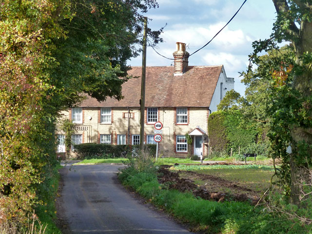
Otham is a small, widely spread village, on the south eastern edge of Maidstone some 2¾ miles from the town centre and 15 miles northwest of Ashford. There are plans to add another 1250 houses to the village which currently has 204 dwellings.](https://s0.geograph.org.uk/geophotos/07/07/76/7077660_c9dbb29c.jpg)
Leeds is a civil parish located in the county of Kent, England. Situated in the picturesque countryside of the North Downs, it covers an area of approximately 7.5 square miles. The parish is named after the River Len, which runs through the village, adding to its charm and beauty.
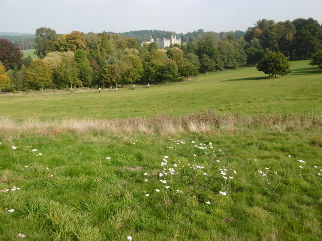
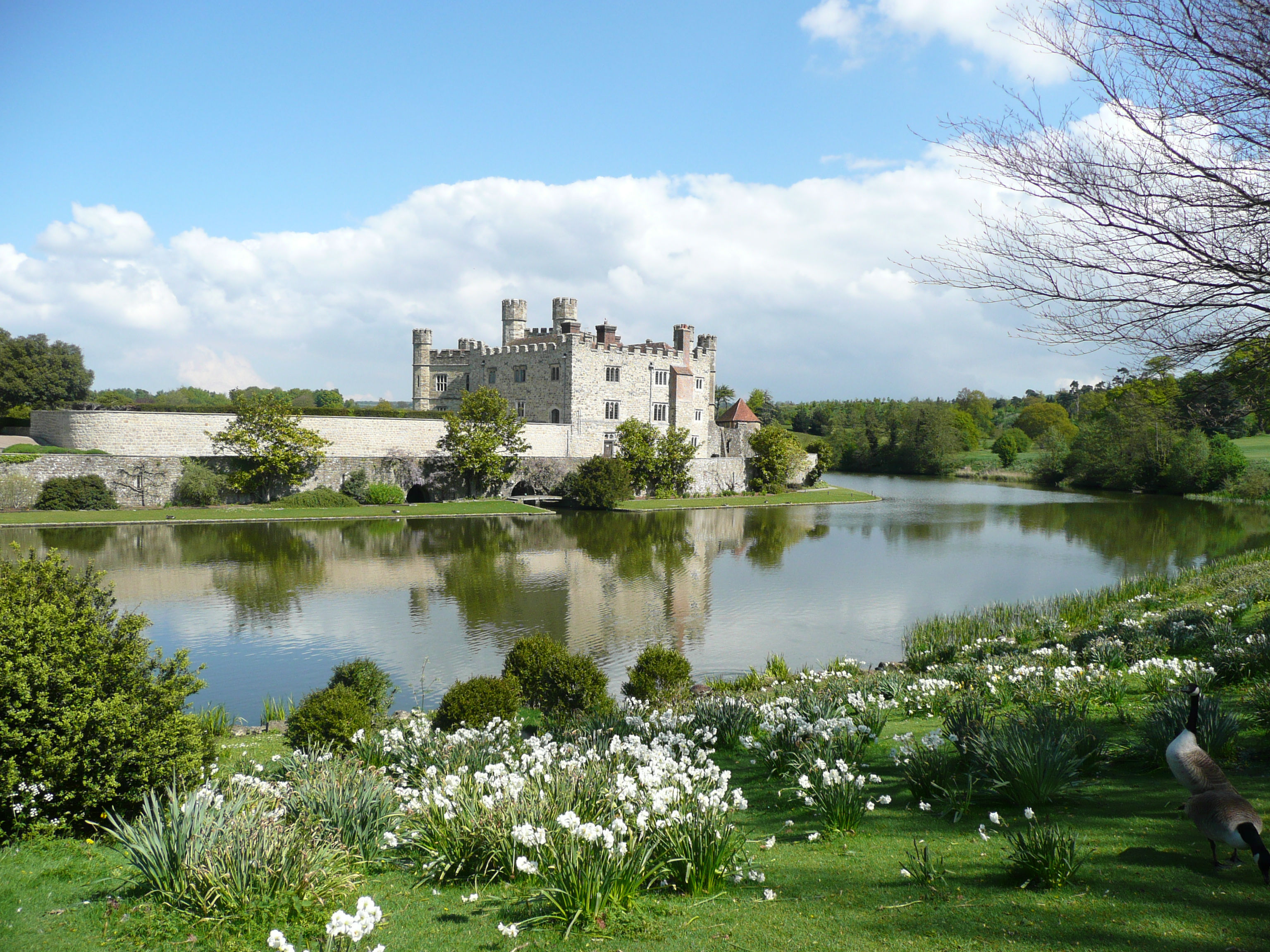
Leeds is a small, rural village with a population of around 1,000 residents. It is well-known for its historic buildings and traditional English architecture, including the Grade I listed Leeds Castle. Dating back to the 12th century, the castle is a major tourist attraction and stands as a testament to Leeds' rich history.
The village itself offers a peaceful and idyllic setting, with tree-lined streets and well-maintained gardens. It has a close-knit community feel and a strong sense of community spirit. Leeds is home to a number of local amenities, including a village hall, a primary school, a post office, and a few independent shops and cafes.
The surrounding countryside provides ample opportunities for outdoor activities, such as hiking, cycling, and horse riding. The area is also dotted with several nature reserves and parks, offering residents and visitors a chance to enjoy the beauty of the natural landscape.
Overall, Leeds, Kent is a charming and picturesque civil parish that offers a peaceful and rural lifestyle. Its rich history, stunning architecture, and beautiful surroundings make it an attractive destination for both tourists and those seeking a tranquil place to call home.
If you have any feedback on the listing, please let us know in the comments section below.
Leeds Images
Images are sourced within 2km of 51.248421/0.605475 or Grid Reference TQ8153. Thanks to Geograph Open Source API. All images are credited.
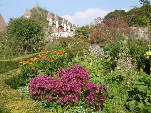
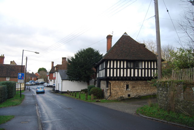
![Stoneacre [1] Stoneacre is a small half-timbered house in Stoneacre Lane, Otham. Built in the 15th century and altered in the 16th century. Purchased in 1920 in a ruinous state by Aymer Vallance who reconstructed it as a Tudor yeoman&#039;s dwelling. In 1928 the property was presented to the National Trust. There is much history and detail at: <span class="nowrap"><a title="https://en.wikipedia.org/wiki/Stoneacre,_Kent" rel="nofollow ugc noopener" href="https://en.wikipedia.org/wiki/Stoneacre,_Kent">Link</a><img style="margin-left:2px;" alt="External link" title="External link - shift click to open in new window" src="https://s1.geograph.org.uk/img/external.png" width="10" height="10"/></span> The house is listed, grade II*, with details at: <span class="nowrap"><a title="https://historicengland.org.uk/listing/the-list/list-entry/1250995" rel="nofollow ugc noopener" href="https://historicengland.org.uk/listing/the-list/list-entry/1250995">Link</a><img style="margin-left:2px;" alt="External link" title="External link - shift click to open in new window" src="https://s1.geograph.org.uk/img/external.png" width="10" height="10"/></span>
Otham is a small, widely spread village, on the southeastern edge of Maidstone, some 2¾ miles from the town centre and 15 miles northwest of Ashford. There are plans to add another 1250 houses to the village which currently has 204 dwellings.](https://s2.geograph.org.uk/geophotos/07/07/76/7077666_ade60e5a.jpg)
![Stoneacre [2] The rear of the house.
Stoneacre is a small half-timbered house in Stoneacre Lane, Otham. Built in the 15th century and altered in the 16th century. Purchased in 1920 in a ruinous state by Aymer Vallance who reconstructed it as a Tudor yeoman&#039;s dwelling. In 1928 the property was presented to the National Trust. There is much history and detail at: <span class="nowrap"><a title="https://en.wikipedia.org/wiki/Stoneacre,_Kent" rel="nofollow ugc noopener" href="https://en.wikipedia.org/wiki/Stoneacre,_Kent">Link</a><img style="margin-left:2px;" alt="External link" title="External link - shift click to open in new window" src="https://s1.geograph.org.uk/img/external.png" width="10" height="10"/></span> The house is listed, grade II*, with details at: <span class="nowrap"><a title="https://historicengland.org.uk/listing/the-list/list-entry/1250995" rel="nofollow ugc noopener" href="https://historicengland.org.uk/listing/the-list/list-entry/1250995">Link</a><img style="margin-left:2px;" alt="External link" title="External link - shift click to open in new window" src="https://s1.geograph.org.uk/img/external.png" width="10" height="10"/></span>
Otham is a small, widely spread village, on the southeastern edge of Maidstone, some 2¾ miles from the town centre and 15 miles northwest of Ashford. There are plans to add another 1250 houses to the village which currently has 204 dwellings.](https://s0.geograph.org.uk/geophotos/07/07/76/7077668_520d7df6.jpg)
![Stoneacre [3] Inside the house.
Stoneacre is a small half-timbered house in Stoneacre Lane, Otham. Built in the 15th century and altered in the 16th century. Purchased in 1920 in a ruinous state by Aymer Vallance who reconstructed it as a Tudor yeoman&#039;s dwelling. In 1928 the property was presented to the National Trust. There is much history and detail at: <span class="nowrap"><a title="https://en.wikipedia.org/wiki/Stoneacre,_Kent" rel="nofollow ugc noopener" href="https://en.wikipedia.org/wiki/Stoneacre,_Kent">Link</a><img style="margin-left:2px;" alt="External link" title="External link - shift click to open in new window" src="https://s1.geograph.org.uk/img/external.png" width="10" height="10"/></span> The house is listed, grade II*, with details at: <span class="nowrap"><a title="https://historicengland.org.uk/listing/the-list/list-entry/1250995" rel="nofollow ugc noopener" href="https://historicengland.org.uk/listing/the-list/list-entry/1250995">Link</a><img style="margin-left:2px;" alt="External link" title="External link - shift click to open in new window" src="https://s1.geograph.org.uk/img/external.png" width="10" height="10"/></span>
Otham is a small, widely spread village, on the southeastern edge of Maidstone, some 2¾ miles from the town centre and 15 miles northwest of Ashford. There are plans to add another 1250 houses to the village which currently has 204 dwellings.](https://s1.geograph.org.uk/geophotos/07/07/76/7077669_4608e9f0.jpg)
![Stoneacre [4] The fine king post roof of the double height hall.
Stoneacre is a small half-timbered house in Stoneacre Lane, Otham. Built in the 15th century and altered in the 16th century. Purchased in 1920 in a ruinous state by Aymer Vallance who reconstructed it as a Tudor yeoman&#039;s dwelling. In 1928 the property was presented to the National Trust. There is much history and detail at: <span class="nowrap"><a title="https://en.wikipedia.org/wiki/Stoneacre,_Kent" rel="nofollow ugc noopener" href="https://en.wikipedia.org/wiki/Stoneacre,_Kent">Link</a><img style="margin-left:2px;" alt="External link" title="External link - shift click to open in new window" src="https://s1.geograph.org.uk/img/external.png" width="10" height="10"/></span> The house is listed, grade II*, with details at: <span class="nowrap"><a title="https://historicengland.org.uk/listing/the-list/list-entry/1250995" rel="nofollow ugc noopener" href="https://historicengland.org.uk/listing/the-list/list-entry/1250995">Link</a><img style="margin-left:2px;" alt="External link" title="External link - shift click to open in new window" src="https://s1.geograph.org.uk/img/external.png" width="10" height="10"/></span>
Otham is a small, widely spread village, on the southeastern edge of Maidstone, some 2¾ miles from the town centre and 15 miles northwest of Ashford. There are plans to add another 1250 houses to the village which currently has 204 dwellings.](https://s3.geograph.org.uk/geophotos/07/07/76/7077671_faf0df8b.jpg)
![Stoneacre [5] Part of the garden.
Stoneacre is a small half-timbered house in Stoneacre Lane, Otham. Built in the 15th century and altered in the 16th century. Purchased in 1920 in a ruinous state by Aymer Vallance who reconstructed it as a Tudor yeoman&#039;s dwelling. In 1928 the property was presented to the National Trust. There is much history and detail at: <span class="nowrap"><a title="https://en.wikipedia.org/wiki/Stoneacre,_Kent" rel="nofollow ugc noopener" href="https://en.wikipedia.org/wiki/Stoneacre,_Kent">Link</a><img style="margin-left:2px;" alt="External link" title="External link - shift click to open in new window" src="https://s1.geograph.org.uk/img/external.png" width="10" height="10"/></span> The house is listed, grade II*, with details at: <span class="nowrap"><a title="https://historicengland.org.uk/listing/the-list/list-entry/1250995" rel="nofollow ugc noopener" href="https://historicengland.org.uk/listing/the-list/list-entry/1250995">Link</a><img style="margin-left:2px;" alt="External link" title="External link - shift click to open in new window" src="https://s1.geograph.org.uk/img/external.png" width="10" height="10"/></span>
Otham is a small, widely spread village, on the southeastern edge of Maidstone, some 2¾ miles from the town centre and 15 miles northwest of Ashford. There are plans to add another 1250 houses to the village which currently has 204 dwellings.](https://s0.geograph.org.uk/geophotos/07/07/76/7077672_1a28408f.jpg)

Leeds is located at Grid Ref: TQ8153 (Lat: 51.248421, Lng: 0.605475)
Administrative County: Kent
District: Maidstone
Police Authority: Kent
What 3 Words
///eyelashes.soulful.roving. Near Harrietsham, Kent
Nearby Locations
Related Wikis
Leeds, Kent
Leeds is a village and civil parish in the Maidstone district of Kent, England. == Location == The village is located five miles (8.0 km) to the east of...

Leeds Priory
Leeds Priory, also known as Leeds Abbey, was a priory in Leeds, Kent, England, that was founded in 1119 and dissolved in 1539. A mansion was later built...

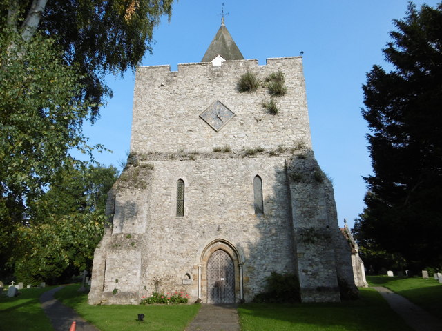
St Nicholas Church, Leeds
St Nicholas is a Church of England parish church in Leeds, Kent first built in the 11th century with additions in the next five centuries. It is a Grade...

Ashbank
Ashbank is a small settlement near Leeds in Kent, England.
Caring, Kent
Caring is a settlement south of Bearsted, near the town of Maidstone in Kent, England. It is located amid several farms on the River Len, a tributary...
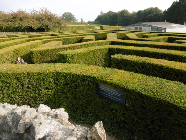
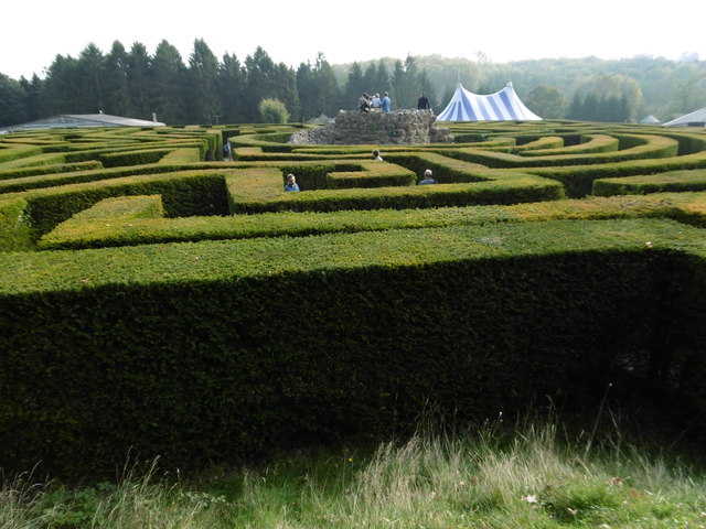
Leeds Castle
Leeds Castle is a castle in Kent, England, 7 miles (11 km) southeast of Maidstone. It is built on islands in a lake formed by the River Len to the east...
Cotuams House
Cotuams Hall is a Georgian hall in Eyhorne Street near Hollingbourne, Kent, England. == Background == Cotuams House was built on the remains of the ancient...

Stoneacre, Kent
Stoneacre is a small National Trust property in Otham, near Maidstone, Kent in southern England. The property is a half-timbered yeoman farmer's house...
Nearby Amenities
Located within 500m of 51.248421,0.605475Have you been to Leeds?
Leave your review of Leeds below (or comments, questions and feedback).