Hilderstone

Civil Parish in Staffordshire Stafford

England

Hilderstone

Mill House Mill House is a grade-2 listed building, also known as "Stone's Throw". The Hilderstone Conservation Area Appraisal describes it thus: "This late 18th century house has an asymmetrical four-bay frontage suggesting an evolution from an earlier building. To the right is the plain elevation of a former outbuilding, which serves as a prominent reminder of the agricultural and industrial origins of the village. Its white painted rendered elevations are a recent replacement for roughcast and give it an air of status".
Mill House Credit: Ian Calderwood

Hilderstone is a civil parish located in the county of Staffordshire, England. It is situated approximately 7 miles southeast of the town of Stafford and covers an area of around 6.5 square miles. The parish is predominantly rural in nature, characterized by open countryside and farmland.

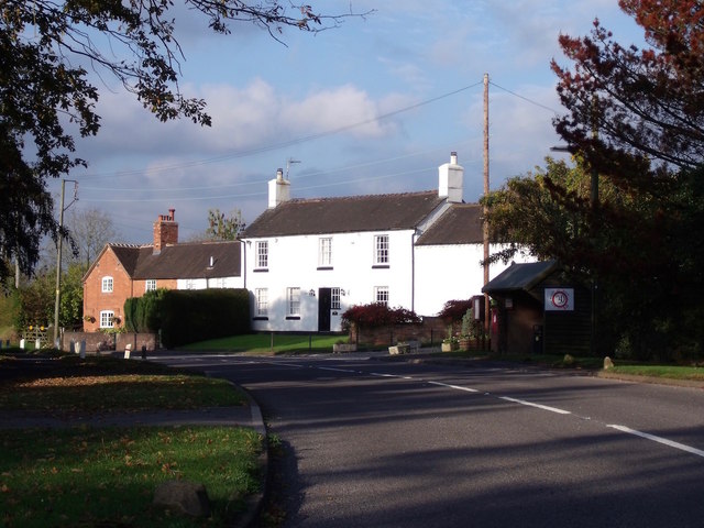
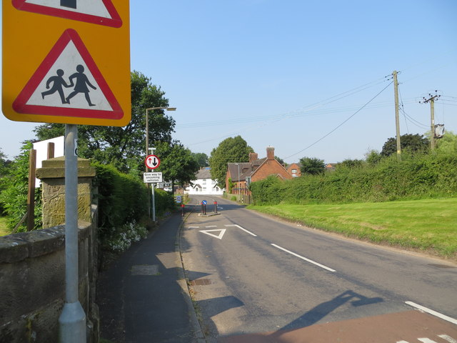
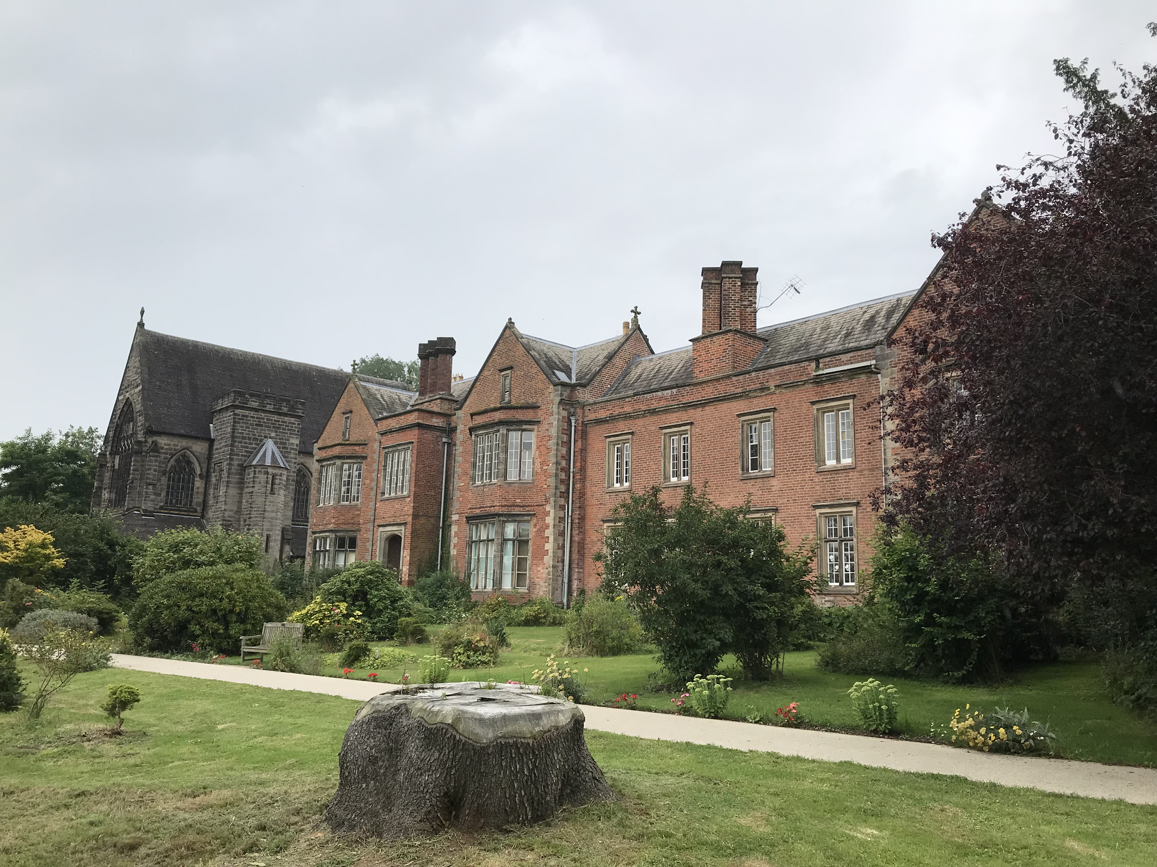
The village of Hilderstone itself is a small, picturesque settlement with a population of around 500 residents. It is known for its charming, traditional cottages and historic buildings, which reflect its long-standing history. The centerpiece of the village is the St. Mary's Church, a Grade I listed building that dates back to the 12th century. The church features stunning architectural details and is a notable landmark within the area.

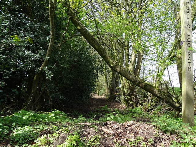
Aside from its architectural heritage, Hilderstone is also known for its natural beauty. The parish is surrounded by rolling hills and offers breathtaking views of the Staffordshire countryside. It is a popular destination for outdoor enthusiasts, offering opportunities for hiking, cycling, and exploring the local flora and fauna.

Despite its rural character, Hilderstone benefits from its proximity to nearby towns and amenities. The village has a primary school, a village hall, and a local pub, providing essential services and a sense of community for its residents. Additionally, the town of Stafford is easily accessible, offering a wider range of facilities including shops, supermarkets, and leisure activities.

Overall, Hilderstone is a picturesque and idyllic civil parish that combines historical charm with a rural setting, making it an attractive place to live for those seeking a peaceful and scenic lifestyle.

If you have any feedback on the listing, please let us know in the comments section below.

Hilderstone Images

Images are sourced within 2km of 52.910369/-2.07393 or Grid Reference SJ9534. Thanks to Geograph Open Source API. All images are credited.

Mill House Mill House is a grade-2 listed building, also known as "Stone's Throw". The Hilderstone Conservation Area Appraisal describes it thus: "This late 18th century house has an asymmetrical four-bay frontage suggesting an evolution from an earlier building. To the right is the plain elevation of a former outbuilding, which serves as a prominent reminder of the agricultural and industrial origins of the village. Its white painted rendered elevations are a recent replacement for roughcast and give it an air of status".
Mill House
Mill House is a grade-2 listed building, also known as "Stone's Throw". The Hilderstone Conservation Area Appraisal describes it thus: "This late 18th century house has an asymmetrical four-bay frontage suggesting an evolution from an earlier building. To the right is the plain elevation of a former outbuilding, which serves as a prominent reminder of the agricultural and industrial origins of the village. Its white painted rendered elevations are a recent replacement for roughcast and give it an air of status".
Development at the old Bird in Hand A new brick skin seems to have been added to what little remains of the old pub. The ultimate intention is to create 6 mews cottages.
Development at the old Bird in Hand
A new brick skin seems to have been added to what little remains of the old pub. The ultimate intention is to create 6 mews cottages.
Old track at Hilderstone This old track appears on the 1856 Ordnance Survey map running somewhat further into the fields than it does now. What remains of it is now part of a public footpath.
Old track at Hilderstone
This old track appears on the 1856 Ordnance Survey map running somewhat further into the fields than it does now. What remains of it is now part of a public footpath.
Ordnance Survey Flush Bracket S9298 This can be found on the wall of Christ Church at Hilderstone.
For more detail see : <span class="nowrap"><a title="http://www.bench-marks.org.uk/bm19212" rel="nofollow ugc noopener" href="http://www.bench-marks.org.uk/bm19212">Link</a><img style="margin-left:2px;" alt="External link" title="External link - shift click to open in new window" src="https://s1.geograph.org.uk/img/external.png" width="10" height="10"/></span>
Ordnance Survey Flush Bracket S9298
This can be found on the wall of Christ Church at Hilderstone. For more detail see : LinkExternal link
Cresswell Road in Hilderstone Looking south-westward from the entrance to Christ Church.
Cresswell Road in Hilderstone
Looking south-westward from the entrance to Christ Church.
Christ Church, Hilderstone <span class="nowrap"><a title="https://en.wikipedia.org/wiki/Hilderstone" rel="nofollow ugc noopener" href="https://en.wikipedia.org/wiki/Hilderstone">Link</a><img style="margin-left:2px;" alt="External link" title="External link - shift click to open in new window" src="https://s1.geograph.org.uk/img/external.png" width="10" height="10"/></span>
Christ Church, Hilderstone
Crossroads south of Hilderstone Looking north, along the B5066, towards the intersection with the B5027.
Crossroads south of Hilderstone
Looking north, along the B5066, towards the intersection with the B5027.
Old Milepost by the B5066, Hilderstone Road, Spot Farm, Stone parish Cast iron post by the B5066, in parish of STONE (STAFFORD District), near Spot Farm, North of Hilderstone, in hedge, on East side of road. Lathe iron casting, erected by the County Council in the 19th/20th century. 

Inscription reads:-
: HILDERSTONE 1 / SANDON 4½ / STAFFORD 9 : : STONE : : LEEK 14½ :
: Chas. Lathe, Tipton. :

Staffordshire HER listed.
HER Number: 51325 <span class="nowrap"><a title="https://www.heritagegateway.org.uk/Gateway/Results_Single.aspx?uid=MST12548&resourceID=1010" rel="nofollow ugc noopener" href="https://www.heritagegateway.org.uk/Gateway/Results_Single.aspx?uid=MST12548&resourceID=1010">Link</a><img style="margin-left:2px;" alt="External link" title="External link - shift click to open in new window" src="https://s1.geograph.org.uk/img/external.png" width="10" height="10"/></span>

Milestone Society National ID: ST_STLK09.
Old Milepost by the B5066, Hilderstone Road, Spot Farm, Stone parish
Cast iron post by the B5066, in parish of STONE (STAFFORD District), near Spot Farm, North of Hilderstone, in hedge, on East side of road. Lathe iron casting, erected by the County Council in the 19th/20th century. Inscription reads:- : HILDERSTONE 1 / SANDON 4½ / STAFFORD 9 : : STONE : : LEEK 14½ : : Chas. Lathe, Tipton. : Staffordshire HER listed. HER Number: 51325 LinkExternal link Milestone Society National ID: ST_STLK09.
Old Milepost by Cresswell Road, Hilderstone parish Cast iron post by the UC road, in parish of HILDERSTONE (STAFFORD District), South of Bird Grove, on grass, on Southeast side of road. Lathe iron casting, erected by the County Council in the 19th/20th century. 

Inscription reads:-
: HILDERSTONE 1 / SANDON 4½ / STAFFORD 9 : : HILDERSTONE : : CHEADLE 7½ :
Maker:-
: Chas. Lathe, Tipton. :

Staffordshire HER.
HER Number: 53358 <span class="nowrap"><a title="https://www.heritagegateway.org.uk/Gateway/Results_Single.aspx?uid=MST17124&resourceID=1010" rel="nofollow ugc noopener" href="https://www.heritagegateway.org.uk/Gateway/Results_Single.aspx?uid=MST17124&resourceID=1010">Link</a><img style="margin-left:2px;" alt="External link" title="External link - shift click to open in new window" src="https://s1.geograph.org.uk/img/external.png" width="10" height="10"/></span>

Milestone Society National ID: ST_STCD09.
Old Milepost by Cresswell Road, Hilderstone parish
Cast iron post by the UC road, in parish of HILDERSTONE (STAFFORD District), South of Bird Grove, on grass, on Southeast side of road. Lathe iron casting, erected by the County Council in the 19th/20th century. Inscription reads:- : HILDERSTONE 1 / SANDON 4½ / STAFFORD 9 : : HILDERSTONE : : CHEADLE 7½ : Maker:- : Chas. Lathe, Tipton. : Staffordshire HER. HER Number: 53358 LinkExternal link Milestone Society National ID: ST_STCD09.
Old Milepost by the B5066, Sandon Road, Hilderstone village Cast iron post by the B5066, in parish of Hilderstone (Stafford District), Hilderstone village, on the verge, on Southeast side of Sandon Road. Lathe iron casting, erected by the County Council in the 19th/20th century. 

Inscription reads:-
: SANDON 3½ / STAFFORD 8 : : HILDERSTONE : : CHEADLE 8½ / LEEK 15½ :
Maker:-
: Chas. Lathe, Tipton. :

Staffordshire HER.
HER Number: 51326 <span class="nowrap"><a title="https://www.heritagegateway.org.uk/Gateway/Results_Single.aspx?uid=MST12549&resourceID=1010" rel="nofollow ugc noopener" href="https://www.heritagegateway.org.uk/Gateway/Results_Single.aspx?uid=MST12549&resourceID=1010">Link</a><img style="margin-left:2px;" alt="External link" title="External link - shift click to open in new window" src="https://s1.geograph.org.uk/img/external.png" width="10" height="10"/></span>

Milestone Society National ID: ST_STLK08
Old Milepost by the B5066, Sandon Road, Hilderstone village
Cast iron post by the B5066, in parish of Hilderstone (Stafford District), Hilderstone village, on the verge, on Southeast side of Sandon Road. Lathe iron casting, erected by the County Council in the 19th/20th century. Inscription reads:- : SANDON 3½ / STAFFORD 8 : : HILDERSTONE : : CHEADLE 8½ / LEEK 15½ : Maker:- : Chas. Lathe, Tipton. : Staffordshire HER. HER Number: 51326 LinkExternal link Milestone Society National ID: ST_STLK08
Old Milepost by the B5066, south of Hilderstone crossroads Cast iron post by the B5066, in parish of Sandon and Burston (Stafford District), Hilderstone crossroads (junction with the B5027), on grass, on East side of road. Lathe iron casting, erected by the County Council in the 19th/20th century. 

Inscription reads:-
: SANDON 2½ / STAFFORD 7 : : SANDON : : HILDERSTONE 1 / CHEADLE 9½ / LEEK 16½ :
Maker:-
: Chas. Lathe, Tipton. :

Staffordshire HER.
HER Number: 51336 <span class="nowrap"><a title="https://www.heritagegateway.org.uk/Gateway/Results_Single.aspx?uid=MST12559&resourceID=1010" rel="nofollow ugc noopener" href="https://www.heritagegateway.org.uk/Gateway/Results_Single.aspx?uid=MST12559&resourceID=1010">Link</a><img style="margin-left:2px;" alt="External link" title="External link - shift click to open in new window" src="https://s1.geograph.org.uk/img/external.png" width="10" height="10"/></span>

Milestone Society National ID: ST_STLK07
Old Milepost by the B5066, south of Hilderstone crossroads
Cast iron post by the B5066, in parish of Sandon and Burston (Stafford District), Hilderstone crossroads (junction with the B5027), on grass, on East side of road. Lathe iron casting, erected by the County Council in the 19th/20th century. Inscription reads:- : SANDON 2½ / STAFFORD 7 : : SANDON : : HILDERSTONE 1 / CHEADLE 9½ / LEEK 16½ : Maker:- : Chas. Lathe, Tipton. : Staffordshire HER. HER Number: 51336 LinkExternal link Milestone Society National ID: ST_STLK07
Roebuck at Hilderstone
The road from Stone Heath, heading north-west From a 222 metre spot height at High Forest Farm.
The road from Stone Heath, heading north-west
From a 222 metre spot height at High Forest Farm.
The road to Stone Heath, heading south-east At a 222 metre spot height near High Forest Farm.
The road to Stone Heath, heading south-east
At a 222 metre spot height near High Forest Farm.
Trees in a hedgerow, Sharpley Heath Just north of High Forest Farm.
Trees in a hedgerow, Sharpley Heath
Just north of High Forest Farm.
Farmland, Sharpley Heath Grass, hedges and trees is the typical mix for farmland in this part of Staffordshire.
Farmland, Sharpley Heath
Grass, hedges and trees is the typical mix for farmland in this part of Staffordshire.
Woodland, Sharpley Heath Mixed woodland was mapped in the same place in the 1880s.
Woodland, Sharpley Heath
Mixed woodland was mapped in the same place in the 1880s.
The road from Sharpley Heath Heading north-west to a junction with Cresswell Road.
The road from Sharpley Heath
Heading north-west to a junction with Cresswell Road.
Show me another place!

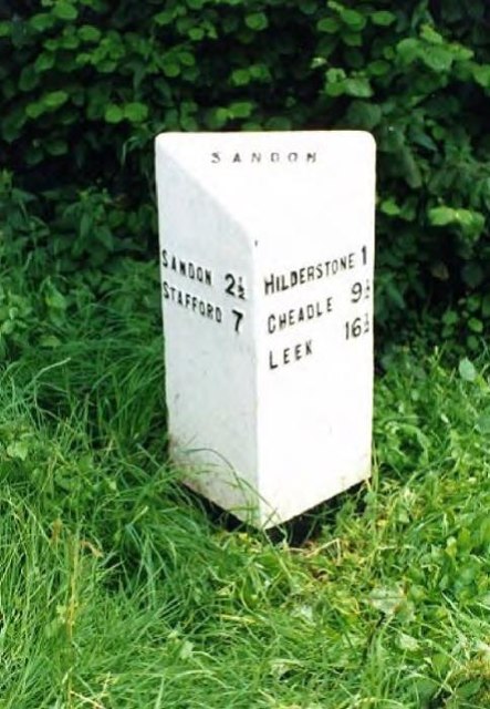
Hilderstone is located at Grid Ref: SJ9534 (Lat: 52.910369, Lng: -2.07393)

Administrative County: Staffordshire

District: Stafford

Police Authority: Staffordshire

What 3 Words

///states.willing.ties. Near Stone, Staffordshire

Related Wikis

Hilderstone

Hilderstone is a village and a civil parish in the English county of Staffordshire. == Location == The village is 8.6 miles (13.8 km) north of the town...

Moddershall

Moddershall is a small village in the borough of Stafford in the county of Staffordshire, England, part of the civil parish of Stone Rural and ecclesiastical...

Stone Rural

Stone Rural is a civil parish in the Stafford district, in the county of Staffordshire, England. The parish includes the settlements of Aston-By-Stone...

Fulford, Staffordshire

Fulford is a village and civil parish about 5 miles (8 km) north east of Stone, in the Stafford district, in the county of Staffordshire, England. The...

Milwich

Milwich is a village and a civil parish in the English county of Staffordshire. == Location == The village is 7.8 miles (12.6 km) north east of the town...

Aston-by-Stone railway station

Aston-by-Stone railway station is a disused railway station in the village of Aston, Staffordshire, England. == History == Opened by the North Staffordshire...

Coton Hill, Staffordshire

Coton Hill is a hamlet in the English county of Staffordshire. Coton Hill is located east of the village of Milwich on the B5027 road between Stone and...

Oulton Abbey

St Mary's Abbey, Oulton is a former Benedictine convent located in the village of Oulton near Stone in Staffordshire, England. The Abbey church is Grade...

Nearby Amenities

Located within 500m of 52.910369,-2.07393
Bus Stop
Old School
Naptan AtcoCode: 3800C727001
Naptan Bearing: NE
Naptan CommonName: Old School
Naptan Indicator: Adj
Naptan Landmark: Old School
Naptan Street: Cresswell Rd
Naptan Verified: no
Source: naptan_import
Lat/Long: 52.9101683/-2.076506
Old School
Naptan AtcoCode: 3800C727002
Naptan Bearing: SW
Naptan BusStopType: CUS
Naptan CommonName: Old School
Naptan Indicator: Opp
Naptan Landmark: Old School
Naptan Street: Cresswell Rd
Naptan Verified: no
Source: naptan_import
Lat/Long: 52.9101144/-2.076372
Hilderstone
Place: village
Wikidata: Q2741112
Lat/Long: 52.9114568/-2.0777905
Barrier: cycle_barrier
Lat/Long: 52.9098524/-2.0801278
Post Box
Post Box Type: lamp
Ref: ST15 230
Royal Cypher: EIIR
Royal Cypher Wikidata: Q33102113
Lat/Long: 52.9084285/-2.0791362
Leisure: playground
Lat/Long: 52.9090668/-2.0798094
Booth: K6
Covered: booth
Disused Amenity: telephone
Listed Status: Grade II
Man Made: telephone_box
Note: red telephone box
Tourism: information
Lat/Long: 52.9097247/-2.0773425
Bench
Lat/Long: 52.9103907/-2.0773604
Waste Basket
Lat/Long: 52.9104346/-2.0774046
Waste Basket
Lat/Long: 52.9119594/-2.0804422
Defibrillator
Defibrillator Location: outside Hilderstone Village Hall
Emergency: defibrillator
Indoor: no
Lat/Long: 52.9094275/-2.0781854
The data included in this document is from www.openstreetmap.org. The data is made available under ODbL.

Have you been to Hilderstone?

Leave your review of Hilderstone below (or comments, questions and feedback).