Brongest

Settlement in Cardiganshire

Wales

Brongest

Sign and gate at entrance to Woollen Mill
Sign and gate at entrance to Woollen Mill Credit: John Firth

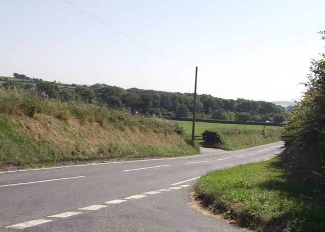
Brongest is a small village located in the county of Cardiganshire, Wales. Situated in the picturesque Teifi Valley, it is surrounded by rolling hills, lush green fields, and dense woodlands. It is positioned approximately 11 miles southeast of the coastal town of Cardigan and 15 miles northeast of the bustling market town of Newcastle Emlyn.

The village itself is quaint and charming, with a population of around 500 residents. Its history can be traced back several centuries, and evidence of its past can still be seen in the form of traditional stone cottages and the ruins of an old mill. Brongest is known for its strong sense of community and friendly atmosphere, with locals often engaging in social activities and events.

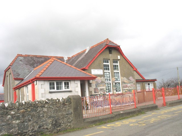
Despite its small size, Brongest offers some amenities to its residents and visitors. These include a village hall, a primary school, and a local pub that serves as a gathering place for the community. The village is also surrounded by beautiful countryside, making it an ideal location for outdoor enthusiasts. Hiking, cycling, and fishing opportunities abound, with the nearby Teifi River providing a tranquil spot for angling.

Overall, Brongest offers a peaceful and idyllic setting, perfect for those seeking a rural retreat away from the hustle and bustle of city life. Its natural beauty and strong community spirit make it an attractive destination for both locals and tourists alike.

If you have any feedback on the listing, please let us know in the comments section below.

Brongest Images

Images are sourced within 2km of 52.080408/-4.447176 or Grid Reference SN3245. Thanks to Geograph Open Source API. All images are credited.

Sign and gate at entrance to Woollen Mill
Road junction at Blaen-Cil-Llech
Ordnance Survey Cut Mark This damaged OS cut mark can be found on the west parapet of the bridge. It marked a point 254.8ft above mean sea level.
Ordnance Survey Cut Mark
This damaged OS cut mark can be found on the west parapet of the bridge. It marked a point 254.8ft above mean sea level.
Ordnance Survey Cut Mark This OS cut mark can be found on the concrete gatepost south side of the road. It marks a point 96.334m above mean sea level.
Ordnance Survey Cut Mark
This OS cut mark can be found on the concrete gatepost south side of the road. It marks a point 96.334m above mean sea level.
Churn Stand There is an Ordnance Survey cut mark on the front of the stand. <a title="https://www.geograph.org.uk/photo/7446206" href="https://www.geograph.org.uk/photo/7446206">Link</a>
Churn Stand
There is an Ordnance Survey cut mark on the front of the stand. Link
Ordnance Survey Cut Mark This OS cut mark can be found on the front of the churn stand. It marks a point 98.167m above mean sea level. <a title="https://www.geograph.org.uk/photo/7446205" href="https://www.geograph.org.uk/photo/7446205">Link</a>
Ordnance Survey Cut Mark
This OS cut mark can be found on the front of the churn stand. It marks a point 98.167m above mean sea level. Link
Churn Stand There is an Ordnance Survey cut mark on the front of the stand. <a title="https://www.geograph.org.uk/photo/7446209" href="https://www.geograph.org.uk/photo/7446209">Link</a>
Churn Stand
There is an Ordnance Survey cut mark on the front of the stand. Link
Ordnance Survey Cut Mark This OS cut mark can be found on the front of the churn stand. It marks a point 98.628m above mean sea level. <a title="https://www.geograph.org.uk/photo/7446207" href="https://www.geograph.org.uk/photo/7446207">Link</a>
Ordnance Survey Cut Mark
This OS cut mark can be found on the front of the churn stand. It marks a point 98.628m above mean sea level. Link
Churn Stand There is an Ordnance Survey cut mark on the front of the stand. <a title="https://www.geograph.org.uk/photo/7446212" href="https://www.geograph.org.uk/photo/7446212">Link</a>
Churn Stand
There is an Ordnance Survey cut mark on the front of the stand. Link
Ordnance Survey Cut Mark This OS cut mark can be found on the churn stand. It marks a point 104.810m above mean sea level. <a title="https://www.geograph.org.uk/photo/7446210" href="https://www.geograph.org.uk/photo/7446210">Link</a>
Ordnance Survey Cut Mark
This OS cut mark can be found on the churn stand. It marks a point 104.810m above mean sea level. Link
Ordnance Survey Cut Mark This OS cut mark can be found on a boulder behind the gate on the NE side of the road. It marks a point 138.088m above mean sea level.
Ordnance Survey Cut Mark
This OS cut mark can be found on a boulder behind the gate on the NE side of the road. It marks a point 138.088m above mean sea level.
Ordnance Survey Cut Mark This OS cut mark can be found on a disturbed boulder at the hedge junction NE side of the road. It marked a point 452.6ft above mean sea level.
Ordnance Survey Cut Mark
This OS cut mark can be found on a disturbed boulder at the hedge junction NE side of the road. It marked a point 452.6ft above mean sea level.
Ordnance Survey Cut Mark This OS cut mark can be found on the SW parapet of the bridge. It marks a point 59.227m above mean sea level.
Ordnance Survey Cut Mark
This OS cut mark can be found on the SW parapet of the bridge. It marks a point 59.227m above mean sea level.
Ordnance Survey Cut Mark This OS cut mark can be found on the wall north side of the road. It marks a point 89.114m above mean sea level.
Ordnance Survey Cut Mark
This OS cut mark can be found on the wall north side of the road. It marks a point 89.114m above mean sea level.
Ordnance Survey Cut Mark This OS cut mark can be found on the stone gatepost west side of the road. It marks a point 114.558m above mean sea level.
Ordnance Survey Cut Mark
This OS cut mark can be found on the stone gatepost west side of the road. It marks a point 114.558m above mean sea level.
Churn Stand There is an Ordnance Survey rivet on the step of the stand. <a title="https://www.geograph.org.uk/photo/7446224" href="https://www.geograph.org.uk/photo/7446224">Link</a>
Churn Stand
There is an Ordnance Survey rivet on the step of the stand. Link
Ordnance Survey Rivet This OS rivet can be found on the step of the churn stand. It marks a point 202.835m above mean sea level. <a title="https://www.geograph.org.uk/photo/7446223" href="https://www.geograph.org.uk/photo/7446223">Link</a>
Ordnance Survey Rivet
This OS rivet can be found on the step of the churn stand. It marks a point 202.835m above mean sea level. Link
River Bank Erosion Here we can see that there is erosion along the bank of the Afon Medini.
River Bank Erosion
Here we can see that there is erosion along the bank of the Afon Medini.
Show me another place!

Brongest is located at Grid Ref: SN3245 (Lat: 52.080408, Lng: -4.447176)

Unitary Authority: Ceredigion

Police Authority: Dyfed Powys

What 3 Words

///radiated.smelter.type. Near Newcastle Emlyn, Ceredigion

Related Wikis

Brongest

Brongest is a small village in the community of Troedyraur, Ceredigion, Wales, which is 68.4 miles (110.1 km) from Cardiff and 188.9 miles (303.9 km)...

Beddgeraint

Beddgeraint is a small village in the community of Penbryn, Ceredigion, Wales, which is 69 miles (111.1 km) from Cardiff and 189.1 miles (304.4 km) from...

Felin-Wnda

Felin-Wnda is a hamlet in the community of Troedyraur, Ceredigion, Wales, which is 69 miles (111.1 km) from Cardiff and 189 miles (304.1 km) from London...

Rhydlewis

Rhydlewis is a small inland village in Ceredigion, Wales. It is situated in an agricultural area with pasture land, woods and low hills. == History... ==

Nearby Amenities

Located within 500m of 52.080408,-4.447176
Troedyraur
Is In: Ceredigion, Wales, UK
Place: hamlet
Source: npe
Wikidata: Q13132036
Wikipedia: en:Troedyraur
Lat/Long: 52.0815189/-4.4433331
Brongest
Place: village
Wikidata: Q16007334
Wikipedia: en:Brongest
Lat/Long: 52.0799183/-4.4492234
Direction: SW
Generator Method: photovoltaic
Generator Output Electricity: yes
Generator Solar Modules: 8
Generator Source: solar
Generator Type: solar_photovoltaic_panel
Location: roof
Power: generator
Lat/Long: 52.0816126/-4.4529793
Direction: SE
Generator Method: photovoltaic
Generator Output Electricity: yes
Generator Solar Modules: 8
Generator Source: solar
Generator Type: solar_photovoltaic_panel
Location: roof
Power: generator
Lat/Long: 52.0816176/-4.4530517
Direction: SSW
Generator Method: photovoltaic
Generator Output Electricity: yes
Generator Solar Modules: 13
Generator Source: solar
Generator Type: solar_photovoltaic_panel
Location: roof
Power: generator
Lat/Long: 52.0795177/-4.4493603
Direction: 165
Generator Method: photovoltaic
Generator Output Electricity: yes
Generator Solar Modules: 17
Generator Source: solar
Generator Type: solar_photovoltaic_panel
Location: roof
Power: generator
Lat/Long: 52.080256/-4.4498478
The data included in this document is from www.openstreetmap.org. The data is made available under ODbL.

Have you been to Brongest?

Leave your review of Brongest below (or comments, questions and feedback).