Bromstone

Settlement in Kent Thanet

England

Bromstone

Below East Cliff, Broadstairs This whole bay and the wave-cut platform are all submerged at high tide.
Below East Cliff, Broadstairs Credit: Trevor Harris

Bromstone is a small village located in the district of Thanet in Kent, England. It is situated approximately 1.5 miles west of Margate, a popular seaside town. The village is surrounded by a mix of farmland and residential areas, providing a peaceful and rural atmosphere.

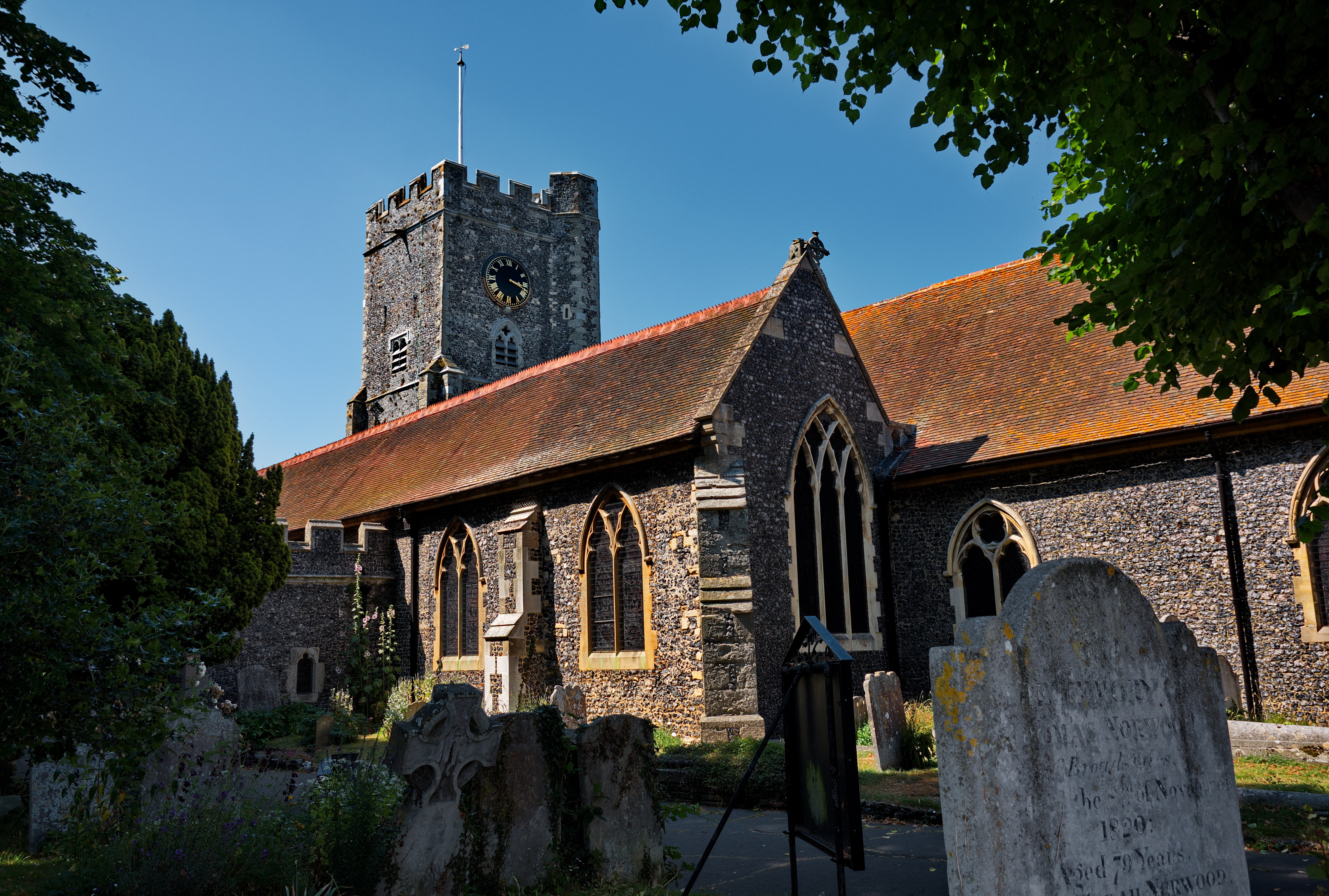
The history of Bromstone can be traced back to the Domesday Book, where it is mentioned as "Brunestone." Over the years, the village has grown, but it has managed to retain its quaint charm and character. The architecture in Bromstone is a mix of traditional cottages and more contemporary houses, adding to the village's unique aesthetic.

Although Bromstone is primarily a residential area, there are a few amenities available to residents and visitors. The village has a local pub, which serves as a hub for socializing and enjoying traditional British pub food. Additionally, there are several small businesses, including a convenience store, allowing residents to conveniently access everyday necessities.

Nature lovers will appreciate the proximity of Bromstone to the beautiful Kent countryside. The village is surrounded by green fields and offers easy access to scenic walking trails. The nearby coastline provides opportunities for coastal walks and enjoying the stunning views of the English Channel.

Overall, Bromstone offers a quiet and picturesque setting, while still being within reach of larger towns and amenities. Its historical significance and natural beauty make it an attractive place to live or visit for those seeking a peaceful and idyllic village experience.

If you have any feedback on the listing, please let us know in the comments section below.

Bromstone Images

Images are sourced within 2km of 51.357081/1.419969 or Grid Reference TR3867. Thanks to Geograph Open Source API. All images are credited.

Below East Cliff, Broadstairs This whole bay and the wave-cut platform are all submerged at high tide.
Below East Cliff, Broadstairs
This whole bay and the wave-cut platform are all submerged at high tide.
Foreshore at Stone Bay The sandy beach transforms into a rock platform at low tide.
Foreshore at Stone Bay
The sandy beach transforms into a rock platform at low tide.
Stone Bay, Broadstairs Looking along the full length from the harbour jetty with Hope Point and North Foreland in the distance. Note the sewage discharge pipe at the beginning of the rocks, hopefully no longer in use!
Stone Bay, Broadstairs
Looking along the full length from the harbour jetty with Hope Point and North Foreland in the distance. Note the sewage discharge pipe at the beginning of the rocks, hopefully no longer in use!
Turnstone on the landing slip, Broadstairs Taking refuge after being chased along the beach by a dog.
Turnstone on the landing slip, Broadstairs
Taking refuge after being chased along the beach by a dog.
Rocks at Low Tide This square just avoids being in the All At Sea category with a small area of weed covered rock getting exposed at low tide. At high tide it's only the beacon at the end of the nearby slipway that isn't under water.
Rocks at Low Tide
This square just avoids being in the All At Sea category with a small area of weed covered rock getting exposed at low tide. At high tide it's only the beacon at the end of the nearby slipway that isn't under water.
White Rocks, Green Weed These strange rounded chalk boulders topped with soft green seaweed emerge at low tide. Some of them definitely resemble dummy heads wearing green wigs.
White Rocks, Green Weed
These strange rounded chalk boulders topped with soft green seaweed emerge at low tide. Some of them definitely resemble dummy heads wearing green wigs.
Beach Cricket at Low Tide An evening game on a rather soggy pitch down by the pier.
Beach Cricket at Low Tide
An evening game on a rather soggy pitch down by the pier.
Rocks at Stone Bay, Broadstairs
Coastal View at Broadstairs View north towards East Cliff.
Coastal View at Broadstairs
View north towards East Cliff.
Breakwater at Broadstairs This beacon warns shipping from coming to close to the land and Broadstairs Pier. This breakwater is only seen at low tide.

Also seen in <a href="https://www.geograph.org.uk/photo/1931281">TR4067 : Walking on the Breakwater</a>
Breakwater at Broadstairs
This beacon warns shipping from coming to close to the land and Broadstairs Pier. This breakwater is only seen at low tide. Also seen in TR4067 : Walking on the Breakwater
Broadstairs Pier As seen from the breakwater.
Broadstairs Pier
As seen from the breakwater.
East Cliff near Broadstairs As seen from the breakwater near Broadstairs Pier.
At lower tides, a small sandy beach can be seen.
East Cliff near Broadstairs
As seen from the breakwater near Broadstairs Pier. At lower tides, a small sandy beach can be seen.
Hard, Broadstairs Harbour There is a very small harbour here, for small boats only, consisting of a short harbour arm protecting a patch of beach that dries out, with this ramp projecting from the outer side of the arm.  This allows small boats to come alongside at lower states of the tide.
Hard, Broadstairs Harbour
There is a very small harbour here, for small boats only, consisting of a short harbour arm protecting a patch of beach that dries out, with this ramp projecting from the outer side of the arm. This allows small boats to come alongside at lower states of the tide.
Slipway from Broadstairs pier
Slipway off Broadstairs Pier
North Cliff, near Broadstairs Apart from part of the cliff in the distance, this entire square is underwater in high tide.  In low tide a series of pools and rocks are revealed.
North Cliff, near Broadstairs
Apart from part of the cliff in the distance, this entire square is underwater in high tide. In low tide a series of pools and rocks are revealed.
Rockpools near Broadstairs Apart from a short jetty, these rocks are the only significant item in this square and they're only visible in low tide.
Rockpools near Broadstairs
Apart from a short jetty, these rocks are the only significant item in this square and they're only visible in low tide.
Broadstairs: Pier slipway This is the slipway that Hywel mentions in <a href="https://www.geograph.org.uk/photo/185267">TR4067 : Rockpools near Broadstairs</a>, and is the only feature above water at high tide.
Broadstairs: Pier slipway
This is the slipway that Hywel mentions in TR4067 : Rockpools near Broadstairs, and is the only feature above water at high tide.
Show me another place!

Bromstone is located at Grid Ref: TR3867 (Lat: 51.357081, Lng: 1.419969)

Administrative County: Kent

District: Thanet

Police Authority: Kent

What 3 Words

///skin.paper.tested. Near St Peters, Kent

Nearby Locations

Bromstone Upton

Related Wikis

The Charles Dickens School

The Charles Dickens School is a co-educational secondary modern school located in Broadstairs in the English county of Kent. The school is named after...

Dane Court Grammar School

Dane Court Grammar School is a coeducational grammar school with academy status in Broadstairs, Kent, UK with approximately 1,249 pupils. == History... ==

Wellesley House School

Wellesley Haddon Dene School is a private day and boarding preparatory school in the coastal town of Broadstairs in the English county of Kent. Founded...

St Peter's Court

St Peter's Court was a preparatory school for boys at Broadstairs in Kent, UK. In 1969, it merged with the nearby Wellesley House School and its site was...

KMFM Thanet

KMFM Thanet is an Independent Local Radio serving the Isle of Thanet and the surrounding areas in Kent, South East England. It is the Thanet region of...

St Peter's, Kent

St Peter's is an area of Broadstairs, a town on the Isle of Thanet in Kent. Historically a village, it was outgrown by the long-dominant settlement of...

Ramsgate Airport

Ramsgate Airport was a civil airfield at Ramsgate, Kent, United Kingdom which opened in July 1935. It was briefly taken over by the Royal Air Force in...

St George's Church of England Foundation School

St George's C of E Foundation School, often abbreviated to St George's, is an all-through school in Broadstairs, Kent, catering for students for 4 to 19...

Nearby Amenities

Located within 500m of 51.357081,1.419969
Crossing
Crossing: unmarked
Crossing Island: yes
Crossing Ref: island
Tactile Paving: yes
Lat/Long: 51.3614093/1.4191754
Barrier: bollard
Foot: yes
Horse: yes
Source: survey
Lat/Long: 51.3533009/1.4229619
Crossing
Check Date Crossing: 2020-11-25
Crossing: uncontrolled
Crossing Island: yes
Crossing Ref: island
Lat/Long: 51.3551598/1.4148389
Crossing
Crossing: uncontrolled
Crossing Island: no
Crossing Ref: zebra
Tactile Paving: yes
Lat/Long: 51.3561262/1.4168433
Crossing
Crossing: unmarked
Crossing Island: yes
Crossing Ref: island
Tactile Paving: yes
Lat/Long: 51.3612804/1.4197416
Noexit: yes
Lat/Long: 51.356955/1.4147956
Traffic Calming: table;choker
Lat/Long: 51.3587969/1.4139238
Noexit: yes
Lat/Long: 51.3587784/1.4147177
Bus Stop
Willow Avenue
Bench: no
Flag: no
Local Ref: NE-bound
Naptan AtcoCode: 2400103297
Naptan Bearing: NE
Naptan BusStopType: MKD
Naptan CommonName: Willow Avenue
Naptan Indicator: NE-bound
Naptan Landmark: Chestnut Drive
Naptan NaptanCode: kntjgtwj
Naptan RevisionNumber: 2
Naptan Status: act
Naptan Street: Willow Avenue
Naptan Verified: no
Public Transport: platform
Ref: kntjgtwj
Shelter: no
Source: naptan_import
Source Date: 2013-11-04
Tactile Paving: no
Lat/Long: 51.3578408/1.4141915
Turning Circle
Lat/Long: 51.3574679/1.4149579
Gadds'
Addr City: Broadstairs
Addr Postcode: CT10 2YD
Addr Street: Hornet Close
Addr Unit: 1
Craft: brewery
Email: info@ramsgatebrewery.co.uk
Fhrs Id: 584489
Operator: The Ramsgate Brewery Ltd
Phone: +44 1843 868453
Source: FHRS Open Data
Source Addr: http://www.ramsgatebrewery.co.uk/contact-us.html
Website: https://www.ramsgatebrewery.co.uk/
Lat/Long: 51.3570599/1.4132579
Hazel Electronics
Addr City: Broadstairs
Addr Housenumber: 12
Addr Postcode: CT10 2YF
Addr Street: Blenheim Close
Phone: +44 1843 866552
Source Addr: http://www.hazelelectronics.co.uk/contact_us.htm
Website: http://www.hazelelectronics.co.uk/
Lat/Long: 51.3566112/1.4133471
P&P Windows Ltd.
Addr City: Broadstairs
Addr Postcode: CT10 2YF
Addr Street: Blenheim Close
Phone: +44 1843 579666
Source Addr Postcode: http://www.pandpwindows.com/
Website: http://www.pandpwindows.com/
Lat/Long: 51.3560468/1.4132421
Top T's (Kent) Limited
Addr City: Broadstairs
Addr Country: GB
Addr Postcode: CT10 2YF
Addr Street: Blenheim Close
Phone: +44 1843 863737
Source Addr Postcode: http://www.topts.co.uk/
Website: http://www.topts.co.uk/
Lat/Long: 51.3564832/1.4137213
Bus Stop
The Ridgeway
Bench: no
Bin: no
Flag: yes
Naptan AtcoCode: 2400100194
Naptan Bearing: E
Naptan CommonName: The Ridgeway
Naptan Indicator: opp
Naptan Landmark: The Ridgeway
Naptan NaptanCode: kntgwdjt
Naptan PlusbusZoneRef: THANET
Naptan Street: Bromstone Road
Naptan Verified: no
Public Transport: platform
Ref: kntgwdjt
Shelter: no
Source: survey;naptan_import
Source Date: 2018-02-12T17:04:00
Tactile Paving: no
Lat/Long: 51.3549458/1.4255466
Barrier: bollard
Bollard: fixed
Lat/Long: 51.3583884/1.4244948
Barrier: bollard
Bollard: fixed
Lat/Long: 51.3582666/1.4250267
Traffic Calming: table
Lat/Long: 51.3577813/1.425024
Bus Stop
The Ridgeway
Bench: no
Bin: no
Flag: yes
Naptan AtcoCode: 2400100192
Naptan Bearing: W
Naptan CommonName: The Ridgeway
Naptan Indicator: adj
Naptan Landmark: The Ridgeway
Naptan NaptanCode: kntgwdwa
Naptan PlusbusZoneRef: THANET
Naptan Street: Bromstone Road
Naptan Verified: no
Public Transport: platform
Ref: kntgwdwa
Shelter: no
Source: naptan_import
Source Date: 2018-02-12T17:03:00
Tactile Paving: no
Lat/Long: 51.3548661/1.4251958
Bus Stop
Wilkes Road
Bench: no
Bin: no
Flag: yes
Lit: yes
Naptan AtcoCode: 2400100196
Naptan Bearing: E
Naptan CommonName: Wilkes Road
Naptan Indicator: adj
Naptan Landmark: Wilkes Road
Naptan NaptanCode: kntgwdwg
Naptan PlusbusZoneRef: THANET
Naptan Street: Bromstone Road
Naptan Verified: no
Public Transport: platform
Ref: kntgwdwg
Shelter: no
Source: naptan_import
Source Date: 2018-02-12T17:08:00
Tactile Paving: no
Lat/Long: 51.355905/1.4213513
Bus Stop
Pysons Road Roundabout
Bench: no
Flag: yes
Naptan AtcoCode: 2400100198
Naptan Bearing: W
Naptan CommonName: Pysons Road Roundabout
Naptan Indicator: W-bound
Naptan Landmark: Pysons Road Roundabout
Naptan NaptanCode: kntgwdjg
Naptan PlusbusZoneRef: THANET
Naptan ShortCommonName: Pysons Road Rbt
Naptan Street: Bromstone Road
Naptan Verified: no
Public Transport: platform
Ref: kntgwdjg
Shelter: no
Short Name: Pysons Road Rbt
Source: naptan_import
Source Date: 2018-02-12T16:25:00
Tactile Paving: no
Lat/Long: 51.3561573/1.4185686
Bus Stop
Fairfield Park
Bench: no
Bin: no
Flag: yes
Naptan AtcoCode: 2400100200
Naptan Bearing: S
Naptan CommonName: Fairfield Park
Naptan Indicator: adj
Naptan Landmark: Nursing Home
Naptan NaptanCode: kntgwdmd
Naptan PlusbusZoneRef: THANET
Naptan Street: Fairfield Road
Naptan Verified: yes
Public Transport: platform
Ref: kntgwdmd
Shelter: no
Source: naptan_import
Source Date: 2018-02-02T12:46:00
Tactile Paving: no
Lat/Long: 51.3599337/1.419238
Bus Stop
Fairfield Park
Bench: no
Bin: no
Flag: yes
Naptan AtcoCode: 2400100202
Naptan Bearing: N
Naptan CommonName: Fairfield Park
Naptan Indicator: opp
Naptan Landmark: Nursing Home
Naptan NaptanCode: kntgwdpa
Naptan PlusbusZoneRef: THANET
Naptan Street: Fairfield Road
Naptan Verified: yes
Public Transport: platform
Ref: kntgwdpa
Shelter: no
Source: naptan_import
Source Date: 2018-02-02T12:47:00
Tactile Paving: no
Lat/Long: 51.3601074/1.4191172
Bus Stop
Collingwood Close
Bench: no
Bin: no
Flag: yes
Lit: yes
Naptan AtcoCode: 2400100204
Naptan Bearing: N
Naptan CommonName: Collingwood Close
Naptan Indicator: opp
Naptan Landmark: Collingwood Close
Naptan NaptanCode: kntgwdmt
Naptan PlusbusZoneRef: THANET
Naptan Street: Fairfield Road
Naptan Verified: yes
Public Transport: platform
Ref: kntgwdmt
Shelter: no
Source: naptan_import
Source Date: 2018-02-02T12:27:00
Tactile Paving: no
Lat/Long: 51.3577982/1.4181306
Bus Stop
Collingwood Close
Bench: no
Bin: no
Lit: yes
Naptan AtcoCode: 2400100206
Naptan Bearing: S
Naptan CommonName: Collingwood Close
Naptan Indicator: adj
Naptan Landmark: Collingwood Close
Naptan NaptanCode: kntgwdpj
Naptan PlusbusZoneRef: THANET
Naptan Street: Fairfield Road
Naptan Verified: yes
Public Transport: platform
Ref: kntgwdpj
Shelter: no
Source: naptan_import
Source Date: 2018-02-02T12:26:00
Tactile Paving: no
Lat/Long: 51.3574721/1.4182069
Bus Stop
Dane Court School
Bench: no
Bin: no
Flag: yes
Lit: yes
Local Ref: adj
Naptan AtcoCode: 2400A047350A
Naptan Bearing: W
Naptan BusStopType: MKD
Naptan CommonName: Dane Court School
Naptan Indicator: adj
Naptan Landmark: Dane Court School
Naptan NaptanCode: kntdwtja
Naptan PlusbusZoneRef: THANET
Naptan RevisionNumber: 4
Naptan Status: act
Naptan Street: Broadstairs Road
Naptan Verified: no
Public Transport: platform
Ref: kntdwtja
Shelter: no
Source: naptan_import
Source Date: 2018-06-13
Tactile Paving: no
Lat/Long: 51.3614446/1.4186322
Bus Stop
Pysons Road Roundabout
Bench: no
Bin: no
Flag: yes
Lit: yes
Naptan AtcoCode: 2400A047750A
Naptan Bearing: SE
Naptan CommonName: Pysons Road Roundabout
Naptan Indicator: SE-bound
Naptan Landmark: Pysons Road Roundabout
Naptan NaptanCode: kntgadgt
Naptan PlusbusZoneRef: THANET
Naptan ShortCommonName: Pysons Road Rbt
Naptan Street: Rumfields Road
Naptan Verified: no
Public Transport: platform
Ref: kntgadgt
Shelter: no
Short Name: Pysons Road Rbt
Source: naptan_import
Source Date: 2018-02-12T16:26:00
Tactile Paving: no
Lat/Long: 51.3568487/1.4170685
Bus Stop
Willow Avenue
Bench: no
Flag: no
Local Ref: SW-bound
Naptan AtcoCode: 2400A047760A
Naptan Bearing: SW
Naptan BusStopType: MKD
Naptan CommonName: Willow Avenue
Naptan Indicator: SW-bound
Naptan Landmark: Rumfields Road
Naptan NaptanCode: kntgadgw
Naptan PlusbusZoneRef: THANET
Naptan RevisionNumber: 5
Naptan Status: act
Naptan Street: Willow Avenue
Naptan Verified: no
Public Transport: platform
Ref: kntgadgw
Shelter: no
Source: naptan_import
Source Date: 2013-11-04
Tactile Paving: no
Lat/Long: 51.3578086/1.4143201
Bus Stop
Wilkes Road
Bench: no
Bin: no
Flag: yes
Naptan AtcoCode: 2400A070510A
Naptan Bearing: NW
Naptan CommonName: Wilkes Road
Naptan Indicator: opp
Naptan Landmark: Wilkes Road
Naptan NaptanCode: kntgdjag
Naptan PlusbusZoneRef: THANET
Naptan Street: Bromstone Road
Naptan Verified: no
Public Transport: platform
Ref: kntgdjag
Shelter: no
Source: naptan_import
Source Date: 2018-02-12T17:10:00
Tactile Paving: no
Lat/Long: 51.3555537/1.421986
Post Box
Check Date: 2022-06-13
Collection Times: Mo-Fr 09:00; Sa 07:00
Operator: Royal Mail
Operator Wikidata: Q638098
Post Box Mounting: metal_post
Post Box Type: lamp
Ref: CT10 104
Royal Cypher: EIIR
Royal Cypher Wikidata: Q33102113
Lat/Long: 51.3590727/1.4189765
Disused Amenity: post_box
Post Box Type: wall
Royal Cypher: VR
Source: survey
Lat/Long: 51.3582269/1.4251042
Bromstone
Place: suburb
Source: OS_OpenData_StreetView
Lat/Long: 51.3569259/1.4195926
Upton
Place: suburb
Source: OS_OpenData_StreetView
Lat/Long: 51.3564067/1.4253642
Traffic Calming: choked_table
Lat/Long: 51.3582894/1.4251896
Bicycle Parking
Access: destination
Bicycle Parking: stands
Capacity: 160
Covered: yes
Cyclestreets Id: 41350
Lat/Long: 51.3612448/1.4179103
Bicycle Parking
Access: destination
Bicycle Parking: wall_loops
Capacity: 64
Covered: yes
Cyclestreets Id: 41361
Note: capacity is an estimate based upon what I can count in a part-visible photo.
Lat/Long: 51.3613885/1.4210957
Bicycle Parking
Access: destination
Bicycle Parking: wall_loops
Capacity: 10
Covered: yes
Cyclestreets Id: 41363
Note: capacity is an estimate based upon what I can count in a part-visible photo.
Lat/Long: 51.3613649/1.4217432
Bicycle Parking
Access: destination
Bicycle Parking: wall_loops
Capacity: 28
Covered: yes
Cyclestreets Id: 41364
Note: capacity is an estimate based upon what I can count in a part-visible photo.
Lat/Long: 51.3613551/1.421862
Bicycle Parking
Access: destination
Covered: yes
Fixme: Verify details.
Note: Guessed that this is cycle parking.
Lat/Long: 51.3613513/1.4219242
Bicycle Parking
Access: destination
Bicycle Parking: stands
Capacity: 10
Covered: no
Cyclestreets Id: 41416
Lat/Long: 51.3601626/1.4186912
Generator Method: photovoltaic
Generator Output Electricity: yes
Generator Source: solar
Generator Type: solar_photovoltaic_panel
Location: roof
Power: generator
Lat/Long: 51.3534436/1.4241967
Generator Method: photovoltaic
Generator Output Electricity: yes
Generator Source: solar
Generator Type: solar_photovoltaic_panel
Location: roof
Power: generator
Lat/Long: 51.3548959/1.424312
Generator Method: photovoltaic
Generator Output Electricity: yes
Generator Source: solar
Generator Type: solar_photovoltaic_panel
Location: roof
Power: generator
Lat/Long: 51.3559997/1.4191702
Generator Method: photovoltaic
Generator Output Electricity: yes
Generator Source: solar
Generator Type: solar_photovoltaic_panel
Location: roof
Power: generator
Lat/Long: 51.3560985/1.4182555
Generator Method: photovoltaic
Generator Output Electricity: yes
Generator Source: solar
Generator Type: solar_photovoltaic_panel
Location: roof
Power: generator
Lat/Long: 51.3563012/1.4175152
Generator Method: photovoltaic
Generator Output Electricity: yes
Generator Source: solar
Generator Type: solar_photovoltaic_panel
Location: roof
Power: generator
Lat/Long: 51.3573012/1.4183146
Generator Method: photovoltaic
Generator Output Electricity: yes
Generator Source: solar
Generator Type: solar_photovoltaic_panel
Location: roof
Power: generator
Lat/Long: 51.3550399/1.4234322
Generator Method: photovoltaic
Generator Output Electricity: yes
Generator Source: solar
Generator Type: solar_photovoltaic_panel
Location: roof
Power: generator
Lat/Long: 51.3556505/1.4186177
Generator Method: photovoltaic
Generator Output Electricity: yes
Generator Source: solar
Generator Type: solar_photovoltaic_panel
Location: roof
Power: generator
Lat/Long: 51.3556748/1.4181966
Generator Method: photovoltaic
Generator Output Electricity: yes
Generator Source: solar
Generator Type: solar_photovoltaic_panel
Location: roof
Power: generator
Lat/Long: 51.3554838/1.4234202
Generator Method: photovoltaic
Generator Output Electricity: yes
Generator Source: solar
Generator Type: solar_photovoltaic_panel
Location: roof
Power: generator
Lat/Long: 51.3580113/1.4198327
Generator Method: photovoltaic
Generator Output Electricity: yes
Generator Source: solar
Generator Type: solar_photovoltaic_panel
Location: roof
Power: generator
Lat/Long: 51.3583564/1.4187679
Generator Method: photovoltaic
Generator Output Electricity: yes
Generator Source: solar
Generator Type: solar_photovoltaic_panel
Location: roof
Power: generator
Lat/Long: 51.3583647/1.4187357
Generator Method: photovoltaic
Generator Output Electricity: yes
Generator Source: solar
Generator Type: solar_photovoltaic_panel
Location: roof
Power: generator
Lat/Long: 51.3574804/1.4183669
Generator Method: photovoltaic
Generator Output Electricity: yes
Generator Source: solar
Generator Type: solar_photovoltaic_panel
Location: roof
Power: generator
Lat/Long: 51.3574913/1.418328
Generator Method: photovoltaic
Generator Output Electricity: yes
Generator Source: solar
Generator Type: solar_photovoltaic_panel
Location: roof
Power: generator
Lat/Long: 51.3578271/1.4179176
Generator Method: photovoltaic
Generator Output Electricity: yes
Generator Source: solar
Generator Type: solar_photovoltaic_panel
Location: roof
Power: generator
Lat/Long: 51.353313/1.4234671
Barrier: kerb
Kerb: lowered
Tactile Paving: yes
Lat/Long: 51.35672/1.4173865
Social Facility
Kent House Nursing Home
Addr City: Broadstairs
Addr Postcode: CT10 2JY
Addr Street: Fairfield Road
Fhrs Id: 555375
Fixme: Confirm location
Social Facility: group_home
Social Facility For: senior
Source: FHRS Open Data
Lat/Long: 51.3598413/1.4187509
Crusties
Addr City: Broadstairs
Addr Postcode: CT10 2YF
Addr Street: Blenheim Close
Addr Unit: 16
Fhrs Id: 637618
Man Made: works
Source: FHRS Open Data
Lat/Long: 51.3562132/1.4135967
Wolseley
Brand: Wolseley
Brand Wikidata: Q8030423
Opening Hours: Mo-Fr 07:30-17:00; Sa 08:00-12:00
Shop: trade
Trade: plumbing
Website: https://www.wolseley.co.uk/branch/broadstairs/
Lat/Long: 51.3571639/1.4131222
City Plumbing
Craft: plumber
Lat/Long: 51.3569877/1.4133735
Bus Stop
Charles Dickens School Grounds
Naptan AtcoCode: 2400102328
Naptan Bearing: N
Naptan CommonName: Charles Dickens School Grounds
Naptan Indicator: o/s
Naptan Landmark: Charles Dickens School
Naptan NaptanCode: kntgtmgw
Naptan ShortCommonName: Charles Dickens Sch
Naptan Street: School Grounds
Naptan Verified: no
Public Transport: platform
Ref: kntgtmgw
Short Name: Charles Dickens Sch
Source: NAPTAN
Source Date: 2018-02-02T12:24:00
Lat/Long: 51.361011/1.4226948
Bus Stop
Bookers
Bench: no
Local Ref: opp
Naptan AtcoCode: 2400108274
Naptan Bearing: SW
Naptan BusStopType: MKD
Naptan CommonName: Bookers
Naptan Indicator: opp
Naptan Landmark: Bookers
Naptan NaptanCode: kntjwpjw
Naptan RevisionNumber: 1
Naptan Status: act
Naptan Street: Pysons Road
Naptan Verified: yes
Public Transport: platform
Ref: kntjwpjw
Shelter: no
Source: naptan_import
Source Date: 2018-02-02
Tactile Paving: no
Lat/Long: 51.3554474/1.4157718
Bus Stop
Bookers
Bench: no
Local Ref: adj
Naptan AtcoCode: 2400108272
Naptan Bearing: NE
Naptan BusStopType: MKD
Naptan CommonName: Bookers
Naptan Indicator: adj
Naptan Landmark: Bookers
Naptan NaptanCode: kntjwpjt
Naptan RevisionNumber: 1
Naptan Status: act
Naptan Street: Pysons Road
Naptan Verified: yes
Public Transport: platform
Ref: kntjwpjt
Shelter: no
Source: naptan_import
Source Date: 2018-02-02
Tactile Paving: no
Lat/Long: 51.3557454/1.4160382
Car Wash
Broadstairs Hand Car Wash
Addr City: Broadstairs
Addr Housename: Broadstairs Hand Car Wash LTD
Addr Housenumber: unit 20
Addr Postcode: CT10 2LE
Addr Street: Patricia Way
Automated: no
Email: broadstairshandcarwash@hotmail.com
Opening Hours: Mo-Sa 08:00-17:30 , Su 10:00-16:00
Payment Cash: yes
Payment Debit Cards: yes
Payment Mastercard: yes
Payment Visa: yes
Phone: +447769390222
Self Service: no
Lat/Long: 51.3550874/1.4140154
The data included in this document is from www.openstreetmap.org. The data is made available under ODbL.

Have you been to Bromstone?

Leave your review of Bromstone below (or comments, questions and feedback).