Harwich

Civil Parish in Essex Tendring

England

Harwich

The Essex Way 167: sea wall To the left is Dovercourt Caravan park, ahead the cranes of Harwich and Felixstowe.
The Essex Way 167: sea wall Credit: Trevor Harris

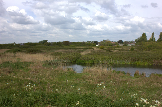
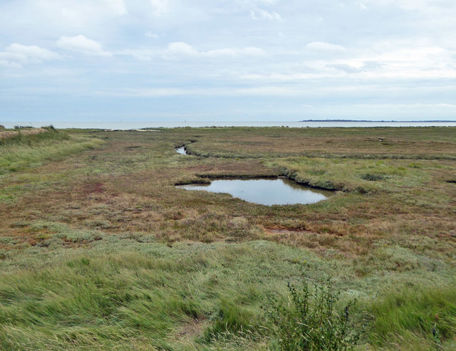
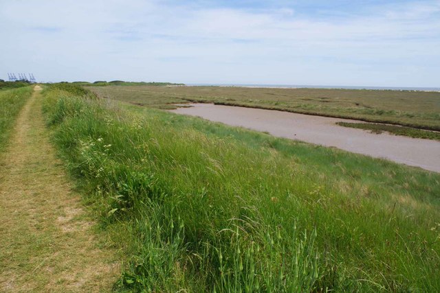
Harwich is a civil parish located in the county of Essex, England. Situated on the eastern coast of the country, it lies on the estuary of the rivers Stour and Orwell. With a population of around 17,000 people, Harwich is a historic town with a rich maritime heritage.

The town has a long history dating back to the 12th century and has been an important port since medieval times. It played a significant role in the development of trade and shipping in the region, particularly during the 17th and 18th centuries when it served as a naval base.

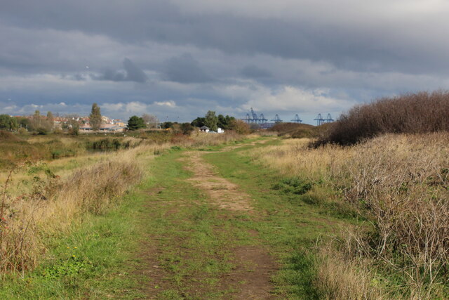
Today, Harwich is still an active port, handling both commercial and passenger traffic. It is connected to the Hook of Holland in the Netherlands by a regular ferry service. The port is also home to a number of shipbuilding and repair yards.

Harwich is known for its charming old town, which features a wealth of historic buildings and landmarks. The Harwich Redoubt, a fortification built in the early 19th century to protect the town from potential invasions, is a popular tourist attraction. Other notable landmarks include the Electric Palace Cinema, one of the oldest purpose-built cinemas in the UK, and the Harwich High Lighthouse.

The town hosts several events and festivals throughout the year, including the Harwich Sea Festival, which celebrates the town's maritime heritage. It also offers a range of recreational activities, such as sailing, fishing, and coastal walks along the estuary.

In summary, Harwich is a picturesque town with a rich history and a thriving maritime industry. It offers visitors a glimpse into its past through its well-preserved buildings and landmarks, while also providing modern amenities and recreational opportunities.

If you have any feedback on the listing, please let us know in the comments section below.

Harwich Images

Images are sourced within 2km of 51.933673/1.264042 or Grid Reference TM2431. Thanks to Geograph Open Source API. All images are credited.

The Essex Way 167: sea wall To the left is Dovercourt Caravan park, ahead the cranes of Harwich and Felixstowe.
The Essex Way 167: sea wall
To the left is Dovercourt Caravan park, ahead the cranes of Harwich and Felixstowe.
Looking to the North Sea at Dovercourt
Dovercourt Caravan Park Despite its name, the site is mainly a park for mobile homes. Taken from the Essex Way footpath.
Dovercourt Caravan Park
Despite its name, the site is mainly a park for mobile homes. Taken from the Essex Way footpath.
Empty beach by the Essex Coast path
Lakes by the Essex Way
Essex Way looking southwards
Saltings, Dovercourt A large bay of saltings, fronted by a sandy upper beach.
Saltings, Dovercourt
A large bay of saltings, fronted by a sandy upper beach.
Essex Way and Hamford Water NNR Sign Looking towards Dovercourt
Essex Way and Hamford Water NNR Sign
Looking towards Dovercourt
Saltmarsh West of Middle Beach Taken from the Essex Way <span class="nowrap"><a title="https://www.ldwa.org.uk/ldp/members/show_path.php?path_name=Essex+Way" rel="nofollow ugc noopener" href="https://www.ldwa.org.uk/ldp/members/show_path.php?path_name=Essex+Way">Link</a><img style="margin-left:2px;" alt="External link" title="External link - shift click to open in new window" src="https://s1.geograph.org.uk/img/external.png" width="10" height="10"/></span>
Saltmarsh West of Middle Beach
Taken from the Essex Way LinkExternal link
Locked-down Dovercourt Caravan Park Looking from the Essex Way across the Borrow Dyke. This should be the beginning of high season but all holiday caravan parks are closed due to Covid-19.
Locked-down Dovercourt Caravan Park
Looking from the Essex Way across the Borrow Dyke. This should be the beginning of high season but all holiday caravan parks are closed due to Covid-19.
Low Tide on the Salt Marsh Near Dovercourt Caravan Park
Low Tide on the Salt Marsh
Near Dovercourt Caravan Park
Essex Way Approaching Dovercourt Footpath 169_43 is part of the Essex Way <span class="nowrap"><a title="https://www.ldwa.org.uk/ldp/members/show_path.php?path_name=Essex+Way" rel="nofollow ugc noopener" href="https://www.ldwa.org.uk/ldp/members/show_path.php?path_name=Essex+Way">Link</a><img style="margin-left:2px;" alt="External link" title="External link - shift click to open in new window" src="https://s1.geograph.org.uk/img/external.png" width="10" height="10"/></span>
Essex Way Approaching Dovercourt
Footpath 169_43 is part of the Essex Way LinkExternal link
Northern End of the Hamford Water National Nature Reserve As seen from the Essex Way
Northern End of the Hamford Water National Nature Reserve
As seen from the Essex Way
Essex Way approaching Dovercourt A small area of heath is encountered before the Essex Way enters the environs of Dovercourt.
Essex Way approaching Dovercourt
A small area of heath is encountered before the Essex Way enters the environs of Dovercourt.
Dovercourt Holiday Park Managed by Park Holidays UK as one of their 31 sites in the south of England <span class="nowrap"><a title="https://www.parkholidays.com/" rel="nofollow ugc noopener" href="https://www.parkholidays.com/">Link</a><img style="margin-left:2px;" alt="External link" title="External link - shift click to open in new window" src="https://s1.geograph.org.uk/img/external.png" width="10" height="10"/></span>
Dovercourt Holiday Park
Managed by Park Holidays UK as one of their 31 sites in the south of England LinkExternal link
Looking towards Middle Beach This narrow strip of sand, on the seaward side of a salt marsh, represents a significant part of Harwich's sandy beaches.
Looking towards Middle Beach
This narrow strip of sand, on the seaward side of a salt marsh, represents a significant part of Harwich's sandy beaches.
Harwich Town railway station, Essex Opened in 1866 by the Great Eastern Railway as the terminus of its line from Manningtree, it replaced an earlier 1854 station which was demolished. 
View north towards the buffers. There had once been a 2nd island platform to the left. The waiting shelter was constructed in 2018 and replaced a short remaining section of station canopy which was removed at the same time. See <a href="https://www.geograph.org.uk/photo/3368379">TM2532 : Harwich Town railway station, Essex, 2012</a> for a view from a similar camera position.
Harwich Town railway station, Essex
Opened in 1866 by the Great Eastern Railway as the terminus of its line from Manningtree, it replaced an earlier 1854 station which was demolished. View north towards the buffers. There had once been a 2nd island platform to the left. The waiting shelter was constructed in 2018 and replaced a short remaining section of station canopy which was removed at the same time. See TM2532 : Harwich Town railway station, Essex, 2012 for a view from a similar camera position.
Track to golf course, Parkeston
Show me another place!

Harwich is located at Grid Ref: TM2431 (Lat: 51.933673, Lng: 1.264042)

Administrative County: Essex

District: Tendring

Police Authority: Essex

What 3 Words

///adopters.loafer.gems. Near Dovercourt, Essex

Nearby Locations

Harwich

Related Wikis

Harwich

Harwich is a town in Essex, England, and one of the Haven ports on the North Sea coast. It is in the Tendring district. Nearby places include Felixstowe...

Dovercourt

Dovercourt is a seaside town and former civil parish, now in the parish of Harwich, in the Tendring district, in the county of Essex, England. It is older...

Harwich and Dovercourt High School

Harwich and Dovercourt High School is a secondary school and sixth form with academy status, located in Harwich in the English county of Essex. It was...

Harwich & Parkeston F.C.

Harwich & Parkeston Football Club is an English football club based in Harwich, Essex. The club are currently members of the Eastern Counties League Division...

Nearby Amenities

Located within 500m of 51.933673,1.264042
Post Box
Post Box Type: pillar
Postal Code: CO12 4HT
Ref: CO12 22
Royal Cypher: EIIR
Royal Cypher Wikidata: Q33102113
Lat/Long: 51.9334313/1.2569598
Mini Roundabout
Direction: clockwise
Lat/Long: 51.9346268/1.2604381
Historic: memorial
Memorial: war_memorial
Lat/Long: 51.9335182/1.2577387
Post Box
Mapillary: 699431728036443
Post Box Mounting: brick_pillar
Post Box Type: wall
Postal Code: CO12 4AJ
Ref: CO12 24
Survey Date: 2022-04-29
Lat/Long: 51.9351198/1.2693463
Post Box
Postal Code: CO12 4EF
Ref: CO12 18
Lat/Long: 51.9311931/1.2641002
Post Box
Postal Code: CO12 4NR
Ref: CO12 79
Lat/Long: 51.9368776/1.2589736
Post Box
Postal Code: CO12 4BH
Ref: CO12 88
Lat/Long: 51.9377135/1.2648055
Post Box
Postal Code: CO12 4EU
Ref: CO12 3
Lat/Long: 51.934684/1.2630617
Bus Stop
The Drive
Bus: yes
Kerb: raised
Naptan AtcoCode: 150029017014
Naptan Bearing: SE
Naptan CommonName: The Drive
Naptan Crossing: Fronk's Road
Naptan Indicator: From
Naptan Landmark: Fronk's Road
Naptan NaptanCode: esxgdmgw
Naptan Street: The Drive
Public Transport: platform
Route Ref: 22a
Source: naptan_import; survey
Lat/Long: 51.9312285/1.2683271
Bus Stop
Harwich School
Bus: yes
Naptan AtcoCode: 150029017015
Naptan Bearing: SE
Naptan CommonName: Harwich School
Naptan Indicator: Opp
Naptan Landmark: Harwich School
Naptan NaptanCode: esxgdmjd
Naptan PlusbusZoneRef: HARWICH
Naptan Street: Hall Lane
Public Transport: platform
Route Ref: 3;103;104
Source: naptan_import; survey
Lat/Long: 51.9307342/1.2617431
Bus Stop
Fronk's Road
Bus: yes
Kerb: raised
Naptan AtcoCode: 150029018008
Naptan Bearing: W
Naptan CommonName: Fronk's Road
Naptan Crossing: The Drive
Naptan Indicator: W-bound
Naptan Landmark: Fronk's Road
Naptan NaptanCode: esxgdmwd
Naptan PlusbusZoneRef: HARWICH
Naptan Street: Fronk's Road
Public Transport: platform
Shelter: yes
Source: naptan_import; survey
Lat/Long: 51.9314214/1.2664813
Bus Stop
Water Tower
Bus: yes
Kerb: raised
Naptan AtcoCode: 150029018009
Naptan Bearing: W
Naptan CommonName: Water Tower
Naptan Indicator: o/s
Naptan Landmark: Water Tower
Naptan NaptanCode: esxgdmwg
Naptan PlusbusZoneRef: HARWICH
Naptan Street: Fronk's Road
Public Transport: platform
Source: naptan_import; survey
Lat/Long: 51.9313941/1.2629224
Bus Stop
Water Tower
Bus: yes
Kerb: raised
Naptan AtcoCode: 150029018010
Naptan Bearing: E
Naptan CommonName: Water Tower
Naptan Indicator: Opp
Naptan Landmark: Water Tower
Naptan NaptanCode: esxgdmwj
Naptan PlusbusZoneRef: HARWICH
Naptan Street: Fronk's Road
Public Transport: platform
Route Ref: 3;4
Source: naptan_import; survey
Lat/Long: 51.9315519/1.2622698
Bus Stop
Deane's Close
Bus: yes
Kerb: raised
Naptan AtcoCode: 150029018011
Naptan Bearing: NW
Naptan CommonName: Deane's Close
Naptan Indicator: Adj
Naptan Landmark: Deane's Close
Naptan NaptanCode: esxgdmwm
Naptan PlusbusZoneRef: HARWICH
Naptan Street: Fronk's Road
Public Transport: platform
Source: naptan_import; survey
Lat/Long: 51.9321681/1.2587555
Bus Stop
War Memorial
Bus: yes
Kerb: raised
Naptan AtcoCode: 150029018012
Naptan Bearing: SE
Naptan CommonName: War Memorial
Naptan Crossing: Main Road
Naptan Indicator: SE-bound
Naptan Landmark: War Memorial
Naptan NaptanCode: esxgdmwp
Naptan PlusbusZoneRef: HARWICH
Naptan Street: Fronk's Road
Public Transport: platform
Source: naptan_import; survey
Lat/Long: 51.9331492/1.2582365
Bus Stop
Scout Hut
Bus: yes
Kerb: raised
Naptan AtcoCode: 150029019007
Naptan Bearing: NW
Naptan CommonName: Scout Hut
Naptan Crossing: Rose Bank
Naptan Indicator: o/s
Naptan Landmark: Scout Hut
Naptan NaptanCode: esxgdmpd
Naptan PlusbusZoneRef: HARWICH
Naptan Street: Parkeston Road
Public Transport: platform
Source: naptan_import
Lat/Long: 51.9356285/1.2595643
Bus Stop
Scout Hut
Bus: yes
Kerb: raised
Naptan AtcoCode: 150029019008
Naptan Bearing: SE
Naptan CommonName: Scout Hut
Naptan Crossing: Rose Bank
Naptan Indicator: Opp
Naptan Landmark: Scout Hut
Naptan NaptanCode: esxgdmpg
Naptan PlusbusZoneRef: HARWICH
Naptan Street: Parkeston Road
Public Transport: platform
Shelter: yes
Source: naptan_import
Lat/Long: 51.9351122/1.2601768
Bus Stop
The Close
Bus: yes
Kerb: raised
Naptan AtcoCode: 150029019011
Naptan Bearing: W
Naptan CommonName: The Close
Naptan Crossing: The Close
Naptan Indicator: Adj
Naptan Landmark: The Close
Naptan NaptanCode: esxgdmpt
Naptan PlusbusZoneRef: HARWICH
Naptan Street: Fryatt Avenue
Public Transport: platform
Source: naptan_import
Lat/Long: 51.9368233/1.2591244
Bus Stop
Harcourt Avenue
Bus: yes
Kerb: raised
Naptan AtcoCode: 150029019012
Naptan Bearing: E
Naptan CommonName: Harcourt Avenue
Naptan Crossing: Harcourt Avenue
Naptan Indicator: Adj
Naptan Landmark: Harcourt Avenue
Naptan NaptanCode: esxgdmpw
Naptan PlusbusZoneRef: HARWICH
Naptan Street: Fryatt Avenue
Public Transport: platform
Source: naptan_import
Lat/Long: 51.9372768/1.2614473
Bus Stop
The Ridgeway
Bus: yes
Kerb: raised
Naptan AtcoCode: 150029019013
Naptan Bearing: S
Naptan CommonName: The Ridgeway
Naptan Indicator: Adj
Naptan Landmark: The Ridgeway
Naptan NaptanCode: esxgdmta
Naptan Street: Douglas Road
Public Transport: platform
Route Ref: 20a
Source: naptan_import
Lat/Long: 51.9362057/1.2675188
Bus Stop
The Close
Bus: yes
Naptan AtcoCode: 150029019Y11
Naptan Bearing: E
Naptan BusStopType: CUS
Naptan CommonName: The Close
Naptan Crossing: The Close
Naptan Indicator: Opp
Naptan Landmark: The Close
Naptan NaptanCode: esxjdjda
Naptan PlusbusZoneRef: HARWICH
Naptan Street: Fryatt Avenue
Naptan Verified: no
Public Transport: platform
Source: naptan_import
Lat/Long: 51.936963/1.2595731
Bus Stop
Harcourt Avenue
Kerb: raised
Naptan AtcoCode: 150029019Y12
Naptan Bearing: W
Naptan BusStopType: CUS
Naptan CommonName: Harcourt Avenue
Naptan Crossing: Harcourt Avenue
Naptan Indicator: Opp
Naptan Landmark: Harcourt Avenue
Naptan NaptanCode: esxjdjdg
Naptan PlusbusZoneRef: HARWICH
Naptan Street: Fryatt Avenue
Public Transport: platform
Source: naptan_import
Lat/Long: 51.9372244/1.2616014
Bus Stop
The Ridgeway
Bus: yes
Kerb: raised
Naptan AtcoCode: 150029019Y13
Naptan Bearing: N
Naptan BusStopType: CUS
Naptan CommonName: The Ridgeway
Naptan Indicator: Opp
Naptan Landmark: The Ridgeway
Naptan NaptanCode: esxgwtgt
Naptan Street: Douglas Road
Public Transport: platform
Route Ref: 20a
Source: naptan_import
Lat/Long: 51.9361576/1.2674217
Bus Stop
Ashley Road
Bus: yes
Kerb: raised
Naptan AtcoCode: 150029020005
Naptan Bearing: E
Naptan CommonName: Ashley Road
Naptan Indicator: Adj
Naptan Landmark: Ashley Road
Naptan NaptanCode: esxgdpdt
Naptan Street: Main Road
Public Transport: platform
Source: naptan_import; survey
Lat/Long: 51.9351667/1.2688395
Bus Stop
Highfield Avenue
Bus: yes
Kerb: raised
Naptan AtcoCode: 150029020006
Naptan Bearing: W
Naptan CommonName: Highfield Avenue
Naptan Indicator: Adj
Naptan Landmark: Highfield Avenue
Naptan NaptanCode: esxgdpdw
Naptan Street: Main Road
Public Transport: platform
Route Ref: 20;22b;102;103;104;105
Shelter: yes
Source: naptan_import; survey
Lat/Long: 51.9349557/1.2669109
Bus Stop
Dovercourt Hospital
Bus: yes
Layby: yes
Naptan AtcoCode: 150029020007
Naptan Bearing: E
Naptan CommonName: Dovercourt Hospital
Naptan Indicator: o/s
Naptan Landmark: Dovercourt Hospital
Naptan NaptanCode: esxgdpga
Naptan PlusbusZoneRef: HARWICH
Naptan Street: Main Road
Public Transport: platform
Route Ref: 20;22a;102;103;104
Source: naptan_import; survey
Timetable Case: yes
Lat/Long: 51.934763/1.2617126
Bus Stop
War Memorial
Bus: yes
Kerb: raised
Naptan AtcoCode: 150029020009
Naptan Bearing: NE
Naptan CommonName: War Memorial
Naptan Crossing: Fronk's Road
Naptan Indicator: NE-bound
Naptan Landmark: War Memorial
Naptan NaptanCode: esxgdpgj
Naptan PlusbusZoneRef: HARWICH
Naptan Street: Main Road
Public Transport: platform
Route Ref: 102;103;104;129
Source: naptan_import; survey
Lat/Long: 51.9341107/1.2590448
Bus Stop
Harwich School
Bus: yes
Flag: no
Kerb: raised
Naptan AtcoCode: 1500AA32
Naptan Bearing: NW
Naptan CommonName: Harwich School
Naptan Indicator: o/s
Naptan Landmark: Harwich School
Naptan NaptanCode: esxgdmjg
Naptan PlusbusZoneRef: HARWICH
Naptan Street: Hall Lane
Note: road markings
Public Transport: platform
Source: naptan_import; survey
Lat/Long: 51.9293445/1.2626939
St. Michael's
Naptan AtcoCode: 1500DT2
Naptan Bearing: W
Naptan BusStopType: CUS
Naptan CommonName: St. Michael's
Naptan Indicator: Adj
Naptan Landmark: St. Michael's
Naptan NaptanCode: esxgmpjw
Naptan Street: Fronk's Road
Naptan Verified: no
Public Transport: platform
Source: naptan_import
Lat/Long: 51.9318537/1.269955
Bus Stop
The Vineway
Bus: yes
Kerb: raised
Naptan AtcoCode: 1500IM1932
Naptan Bearing: E
Naptan CommonName: The Vineway
Naptan Crossing: The Vineway
Naptan Indicator: Towards
Naptan Landmark: The Vineway
Naptan NaptanCode: esxadmtd
Naptan Street: Deepdale Road
Naptan Verified: no
Public Transport: platform
Source: naptan_import
Lat/Long: 51.937222/1.264394
Bus Stop
The Vineway
Bus: yes
Kerb: raised
Naptan AtcoCode: 1500IM1932AA
Naptan Bearing: W
Naptan BusStopType: CUS
Naptan CommonName: The Vineway
Naptan Crossing: The Vineway
Naptan Indicator: From
Naptan Landmark: The Vineway
Naptan NaptanCode: esxgwpgw
Naptan Street: Deepdale Road
Naptan Verified: no
Note: bus bay marked on road
Public Transport: platform
Source: naptan_import
Lat/Long: 51.9371656/1.2644978
Bus Stop
Dovercourt Hospital
Bus: yes
Kerb: raised
Naptan AtcoCode: 1500IM54
Naptan Bearing: W
Naptan CommonName: Dovercourt Hospital
Naptan Indicator: Opp
Naptan Landmark: Dovercourt Hospital
Naptan NaptanCode: esxgdpgd
Naptan PlusbusZoneRef: HARWICH
Naptan Street: Main Road
Public Transport: platform
Shelter: yes
Source: naptan_import; survey
Timetable Case: yes
Lat/Long: 51.9346716/1.2621183
Bus Stop
St. Michael's
Bus: yes
Kerb: raised
Naptan AtcoCode: 1500IM83
Naptan Bearing: E
Naptan CommonName: St. Michael's
Naptan Indicator: Opp
Naptan Landmark: St. Michael's
Naptan NaptanCode: esxgdmwa
Naptan Street: Fronk's Road
Public Transport: platform
Route Ref: 3;4
Shelter: yes
Source: naptan_import; survey
Lat/Long: 51.9317544/1.2684136
Bus Stop
Spring Meadow School
Bus: yes
Naptan AtcoCode: 1500SPRMDSCH
Naptan Bearing: SW
Naptan BusStopType: CUS
Naptan CommonName: Spring Meadow School
Naptan Indicator: o/s
Naptan Landmark: Spring Meadow School
Naptan NaptanCode: esxjdmgj
Naptan PlusbusZoneRef: HARWICH
Naptan Status: ina
Naptan Street: Pound Farm Drive
Naptan Verified: no
Public Transport: platform
Source: naptan_import
Lat/Long: 51.9353299/1.2578103
Crossing
Lat/Long: 51.9347226/1.2626149
Crossing
Crossing: marked
Lat/Long: 51.9335021/1.2567702
Atm
Operator: Co-operative Bank
Lat/Long: 51.9333481/1.257702
Pharmacy
Borno Pharmacy
Addr City: Harwich
Addr Housename: Fryatt Hospital
Addr Housenumber: 419
Addr Postcode: CO12 4ET
Addr Street: Main Road
Dispensing: yes
Healthcare: pharmacy
Lat/Long: 51.933713/1.2603749
Barrier: cycle_barrier
Lat/Long: 51.9334904/1.2699499
Barrier: bollard
Lat/Long: 51.9338979/1.2698082
Barrier: bollard
Lat/Long: 51.934364/1.2703386
Barrier: bollard
Lat/Long: 51.9347268/1.2702136
Barrier: bollard
Lat/Long: 51.9339217/1.2699899
Barrier: bollard
Lat/Long: 51.9339739/1.2703901
Crossing
Lat/Long: 51.9336936/1.2611186
Crossing
Lat/Long: 51.933945/1.2603313
Barrier: bollard
Lat/Long: 51.9333301/1.2687965
Leisure: pitch
Sport: soccer
Lat/Long: 51.9366644/1.2620266
Defibrillator
Defibrillator Location: On outside wall between shops "Reedmans" and "Golden Scissors" on Main Road
Emergency: defibrillator
Indoor: no
Mapillary: 1386456495601648
Ref GB The Circuit: 6CCDC541-2C20-4549-AAF2-AFBD014FD6E8
Survey Date: 2023-11-05
Lat/Long: 51.9335813/1.2567599
Atm
Bank of Ireland
Brand: Bank of Ireland
Brand Wikidata: Q806689
Brand Wikipedia: en:Bank of Ireland
Operator: Bank of Ireland
Operator Wikidata: Q806689
Source: local_knowledge
Lat/Long: 51.9334162/1.2569593
Noexit: yes
Lat/Long: 51.9336488/1.2623405
Entrance: main
Lat/Long: 51.934158/1.2620235
Noexit: yes
Lat/Long: 51.9337713/1.2623253
Crossing
Crossing: uncontrolled
Lat/Long: 51.9341358/1.26152
Bicycle Parking
Bicycle Parking: stands
Capacity: 18
Covered: no
Lat/Long: 51.9340788/1.261855
Noexit: yes
Lat/Long: 51.9336153/1.2623449
Post Office
Upper Dovercourt Post Office
Addr City: Harwich
Addr Housename: WHSmith
Addr Housenumber: 477
Addr Postcode: CO12 4HT
Addr Street: Main Road
Addr Suburb: Dovercourt
Brand: Post Office
Brand Wikidata: Q1783168
Contact Website: https://www.postoffice.co.uk/branch-finder/1381164/upper-dovercourt
Opening Hours: Mo-Fr 08:30-17:30; Sa 09:00-12:30
Ref Pol Id: 2483
Source: pol_branch_list_2018-02
Lat/Long: 51.9333516/1.2569943
Bicycle Parking
Access: private
Bicycle Parking: stands
Capacity: 10
Covered: yes
Lat/Long: 51.9344204/1.2632207
Bicycle Parking
Access: private
Bicycle Parking: stands
Capacity: 10
Covered: yes
Lat/Long: 51.9341261/1.2633092
The data included in this document is from www.openstreetmap.org. The data is made available under ODbL.

Have you been to Harwich?

Leave your review of Harwich below (or comments, questions and feedback).