Hamerton and Steeple Gidding

Civil Parish in Huntingdonshire Huntingdonshire

England

Hamerton and Steeple Gidding

Hamerton, All Saints
Hamerton, All Saints Credit: Dave Kelly

Hamerton and Steeple Gidding is a civil parish located in the county of Huntingdonshire, England. Situated in the east of the county, the parish covers an area of approximately 10 square miles. The villages of Hamerton and Steeple Gidding are the main settlements within the parish.

Hamerton is a small, picturesque village with a population of around 150 residents. It is characterized by its charming thatched cottages and quiet rural atmosphere. The village is surrounded by beautiful countryside, with rolling hills and meadows providing a scenic backdrop.

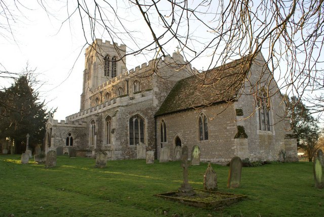
Steeple Gidding, the neighboring village, is equally tranquil and has a population of approximately 120 residents. It takes its name from the church tower that dominates the village's skyline. The church, dedicated to St. Andrew, is a prominent feature and dates back to the 13th century. It boasts stunning stained glass windows and intricate architectural details.

Both villages have a strong sense of community and host various events throughout the year, including fairs, festivals, and community gatherings. There are also several local amenities, including a village hall, a primary school, and a pub.

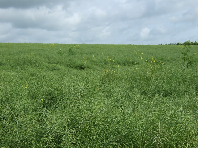
The surrounding countryside offers ample opportunities for outdoor activities, such as walking, cycling, and horse riding. The area is known for its diverse wildlife, including various bird species, making it popular among nature enthusiasts.

Overall, Hamerton and Steeple Gidding provide a peaceful and idyllic setting, perfect for those seeking a rural retreat while still being within easy reach of nearby towns and cities.

If you have any feedback on the listing, please let us know in the comments section below.

Hamerton and Steeple Gidding Images

Images are sourced within 2km of 52.405074/-0.334005 or Grid Reference TL1379. Thanks to Geograph Open Source API. All images are credited.

Hamerton, All Saints
Bridleway to Grange Farm By the field edge the bridleway to Grange Farm
Bridleway to Grange Farm
By the field edge the bridleway to Grange Farm
Minor road junction in Hamerton Roads to Leighton Bromswold, Winwick, Sawpit lane and Great Gidding can be selected from this junction.
Minor road junction in Hamerton
Roads to Leighton Bromswold, Winwick, Sawpit lane and Great Gidding can be selected from this junction.
Minor road junction with a grass centre A classic grass triangle in the middle of a road junction.
Minor road junction with a grass centre
A classic grass triangle in the middle of a road junction.
Footpath off High Street
High Street (Roman Road) heading east
Footpath to Hamerton
Crop field, Salome Farm
Vauxhall floodmobile The obvious "Road Closed" and "Flood" signs and the liquid material covering the road were meant for somebody else to take notice of as this bloke sits on his car door.
Heavy rain, about 25mm in the surrounding area on already saturated farmland brought out the Alconbury Brook to flood state within 4-5 hours. Historically an area prone to flooding and features here <span class="nowrap"><a title="http://www.environment-agency.gov.uk/homeandleisure/floods/34681.aspx?area=052FWFAB1EL&page=1&type=Region&term=Anglian" rel="nofollow ugc noopener" href="http://www.environment-agency.gov.uk/homeandleisure/floods/34681.aspx?area=052FWFAB1EL&page=1&type=Region&term=Anglian">Link</a><img style="margin-left:2px;" alt="External link" title="External link - shift click to open in new window" src="https://s1.geograph.org.uk/img/external.png" width="10" height="10"/></span> quite regularly. No local properties were at risk of flooding.
Vauxhall floodmobile
The obvious "Road Closed" and "Flood" signs and the liquid material covering the road were meant for somebody else to take notice of as this bloke sits on his car door. Heavy rain, about 25mm in the surrounding area on already saturated farmland brought out the Alconbury Brook to flood state within 4-5 hours. Historically an area prone to flooding and features here LinkExternal link quite regularly. No local properties were at risk of flooding.
Hamerton floods A road prone to quick flooding by the Alconbury Brook.
Heavy rain, about 25mm in the surrounding area on already saturated farmland brought out the Alconbury Brook to flood state within 4-5 hours. Historically an area prone to flooding and features here <span class="nowrap"><a title="http://www.environment-agency.gov.uk/homeandleisure/floods/34681.aspx?area=052FWFAB1EL&page=1&type=Region&term=Anglian" rel="nofollow ugc noopener" href="http://www.environment-agency.gov.uk/homeandleisure/floods/34681.aspx?area=052FWFAB1EL&page=1&type=Region&term=Anglian">Link</a><img style="margin-left:2px;" alt="External link" title="External link - shift click to open in new window" src="https://s1.geograph.org.uk/img/external.png" width="10" height="10"/></span> quite regularly.
Hamerton floods
A road prone to quick flooding by the Alconbury Brook. Heavy rain, about 25mm in the surrounding area on already saturated farmland brought out the Alconbury Brook to flood state within 4-5 hours. Historically an area prone to flooding and features here LinkExternal link quite regularly.
Footpath beside Hamerton Grove
Huntingdonshire countryside west of Hamerton
Road from Winwick to Hamerton
Leighton Road, Hamerton The road from Hamerton to Leighton Bromswold
Leighton Road, Hamerton
The road from Hamerton to Leighton Bromswold
Sawpit Lane, Hamerton
Alconbury Brook, Hamerton Taken looking east from School Lane
Alconbury Brook, Hamerton
Taken looking east from School Lane
Alconbury Brook, Hamerton Taken from School Lane looking west.
Alconbury Brook, Hamerton
Taken from School Lane looking west.
Thatched cottage, Hamerton This cottage stands at the junction of Main Street and Gidding Road.
Thatched cottage, Hamerton
This cottage stands at the junction of Main Street and Gidding Road.
Show me another place!

Hamerton and Steeple Gidding is located at Grid Ref: TL1379 (Lat: 52.405074, Lng: -0.334005)

Administrative County: Cambridgeshire

District: Huntingdonshire

Police Authority: Cambridgeshire

What 3 Words

///ducks.modifies.maddening. Near Sawtry, Cambridgeshire

Related Wikis

Hamerton Zoo Park

Hamerton Zoo Park is situated in Hamerton, near Sawtry, Huntingdonshire, England. == Development == Planning permission for change of use from agricultural...

Hamerton

Hamerton is a village in and former civil parish, now in the parish of Hamerton and Steeple Gidding, in Cambridgeshire, England. Hamerton lies approximately...

St Andrew's Church, Steeple Gidding

St Andrew's Church is a redundant Anglican church in the hamlet of Steeple Gidding, about 10 miles (16 km) northwest of Huntingdon, Cambridgeshire, England...

Little Gidding

Little Gidding is a small village and civil parish in Cambridgeshire, England. It lies approximately 9 miles (14 km) northwest of Huntingdon, near Sawtry...

Winwick, Cambridgeshire

Winwick is a village and civil parish in Cambridgeshire, England. Winwick lies approximately 10 miles (16 km) north-west of Huntingdon. It is a crossroads...

Buckworth

Buckworth is a village and civil parish in Cambridgeshire, England. Buckworth lies approximately 7 miles (11 km) northwest of Huntingdon and covers an...

Aversley Wood

Aversley Wood is a 62.3 hectares (154 acres) biological Site of Special Scientific Interest south-west of Sawtry in Cambridgeshire. It is owned and managed...

Great Gidding

Great Gidding is a village and civil parish in the Huntingdonshire district of Cambridgeshire, England.Great Gidding lies approximately 10 miles (16 km...

Nearby Amenities

Located within 500m of 52.405074,-0.334005
Hamerton
Place: village
Lat/Long: 52.4053221/-0.3318714
Bus Stop
Sawpit Lane
Bus: yes
Naptan AtcoCode: 0500HHAME001
Naptan Bearing: W
Naptan BusStopType: CUS
Naptan CommonName: Sawpit Lane
Naptan Indicator: near
Naptan Landmark: Sawpit Lane
Naptan NaptanCode: cmbdpdmw
Naptan ShortCommonName: Sawpit Lane
Naptan Street: Hamerton Road
Naptan Verified: no
Public Transport: platform
Source: naptan_import
Lat/Long: 52.4050152/-0.3314837
Bus Stop
Sawpit Lane
Bus: yes
Naptan AtcoCode: 0500HHAME002
Naptan Bearing: E
Naptan BusStopType: CUS
Naptan CommonName: Sawpit Lane
Naptan Indicator: opp
Naptan Landmark: Sawpit Lane
Naptan NaptanCode: cmbdpdpa
Naptan ShortCommonName: Sawpit Lane
Naptan Street: Hamerton Road
Naptan Verified: no
Public Transport: platform
Source: naptan_import
Lat/Long: 52.4050863/-0.3314222
Post Box
Ref: PE28 121
Lat/Long: 52.4027165/-0.3315017
Power: pole
Lat/Long: 52.4033419/-0.3320633
Power: pole
Lat/Long: 52.4045399/-0.3341981
Power: pole
Lat/Long: 52.4048801/-0.3371593
Power: pole
Lat/Long: 52.4042386/-0.3332435
Power: pole
Lat/Long: 52.4047035/-0.3357645
Power: pole
Lat/Long: 52.4039802/-0.3324549
Power: pole
Lat/Long: 52.4029035/-0.3385164
Power: pole
Lat/Long: 52.4037265/-0.3378993
Power: pole
Lat/Long: 52.4021639/-0.3391386
Power: pole
Lat/Long: 52.4043172/-0.3374152
Power: pole
Lat/Long: 52.4091032/-0.333211
Power: pole
Lat/Long: 52.4062432/-0.3358313
Power: pole
Lat/Long: 52.4084323/-0.3338413
Power: pole
Lat/Long: 52.4077322/-0.3344984
Power: pole
Lat/Long: 52.4069844/-0.3351688
Power: pole
Lat/Long: 52.4055512/-0.3364779
Building: yes
Lat/Long: 52.4039898/-0.3378675
The data included in this document is from www.openstreetmap.org. The data is made available under ODbL.

Have you been to Hamerton and Steeple Gidding?

Leave your review of Hamerton and Steeple Gidding below (or comments, questions and feedback).