Fishtoft

Civil Parish in Lincolnshire Boston

England

Fishtoft

The Ball House, Fishtoft A touch of Brewer's Tudor.
In Fishtoft parish but some distance from the village.
The Ball House, Fishtoft Credit: Jonathan Thacker

Fishtoft is a civil parish located in the county of Lincolnshire, England. Situated just south of the historic town of Boston, it covers an area of approximately 5.6 square kilometers. The parish is bordered by the A52 road to the south and is crossed by the South Forty Foot Drain.

Fishtoft is primarily a residential area, with a mix of housing styles ranging from traditional cottages to more modern developments. The population of the parish stands at around 2,000 residents. The community is diverse, consisting of both families and older individuals, and is known for its friendly and welcoming atmosphere.

The parish is home to a number of amenities, including a primary school, a church, and several shops and businesses. Education is well-served, with Fishtoft Primary School providing education for children aged 3 to 11 years old. The parish also benefits from easy access to the nearby town of Boston, which offers a wider range of services, such as supermarkets, healthcare facilities, and leisure activities.

Fishtoft is surrounded by picturesque countryside, making it an attractive location for those who enjoy outdoor activities. The area is known for its farming heritage, and agriculture continues to play a significant role in the local economy.

Overall, Fishtoft is a peaceful and close-knit community that offers a convenient location for residents, with easy access to both rural and urban amenities.

If you have any feedback on the listing, please let us know in the comments section below.

Fishtoft Images

Images are sourced within 2km of 52.970598/0.017538 or Grid Reference TF3543. Thanks to Geograph Open Source API. All images are credited.
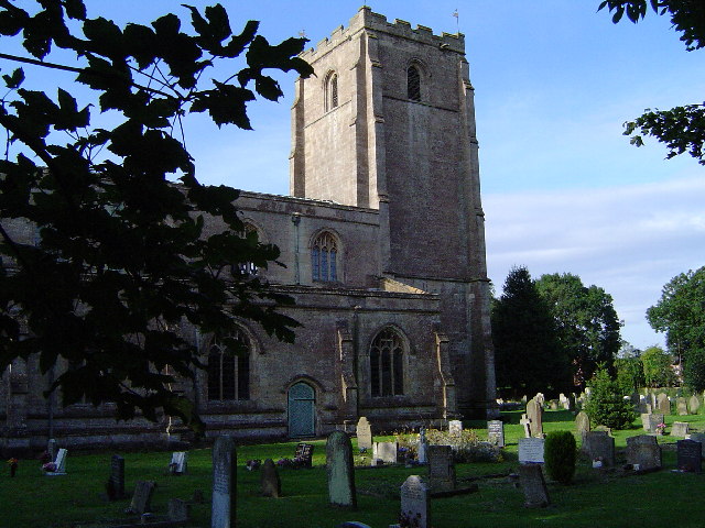
The Ball House, Fishtoft A touch of Brewer's Tudor.
In Fishtoft parish but some distance from the village.
The Ball House, Fishtoft
A touch of Brewer's Tudor. In Fishtoft parish but some distance from the village.
The former route of Wainfleet Road
A glimpse of Rochford Tower Rochford Tower is the remains of a fifteenth century tower house <span class="nowrap"><a title="https://historicengland.org.uk/listing/the-list/list-entry/1062088?section=official-list-entry" rel="nofollow ugc noopener" href="https://historicengland.org.uk/listing/the-list/list-entry/1062088?section=official-list-entry">Link</a><img style="margin-left:2px;" alt="External link" title="External link - shift click to open in new window" src="https://s1.geograph.org.uk/img/external.png" width="10" height="10"/></span>
A glimpse of Rochford Tower
Rochford Tower is the remains of a fifteenth century tower house LinkExternal link
Footpath to Boston Boston Stump almost immediately ahead.
Footpath to Boston
Boston Stump almost immediately ahead.
Pond and St. Nicholas' church, Skirbeck
Uncultivated field and power line
A sea of plastic off Grovefield Lane
Clamp Gate Bridge Crosses the Hobhole Drain.
Clamp Gate Bridge
Crosses the Hobhole Drain.
Footpath alongside The Haven
Church of St. Nicholas, Skirbeck Boston's oldest church <span class="nowrap"><a title="https://historicengland.org.uk/listing/the-list/list-entry/1388859?section=official-list-entry" rel="nofollow ugc noopener" href="https://historicengland.org.uk/listing/the-list/list-entry/1388859?section=official-list-entry">Link</a><img style="margin-left:2px;" alt="External link" title="External link - shift click to open in new window" src="https://s1.geograph.org.uk/img/external.png" width="10" height="10"/></span> of which St. Botolph's (the Stump) was a mere chapel of ease until the fourteenth century.
Church of St. Nicholas, Skirbeck
Boston's oldest church LinkExternal link of which St. Botolph's (the Stump) was a mere chapel of ease until the fourteenth century.
The churchyard and Skirbeck Hall Skirbeck Hall <span class="nowrap"><a title="https://historicengland.org.uk/listing/the-list/list-entry/1388860?section=official-list-entry" rel="nofollow ugc noopener" href="https://historicengland.org.uk/listing/the-list/list-entry/1388860?section=official-list-entry">Link</a><img style="margin-left:2px;" alt="External link" title="External link - shift click to open in new window" src="https://s1.geograph.org.uk/img/external.png" width="10" height="10"/></span> was for many years The Rectory.
The churchyard and Skirbeck Hall
Skirbeck Hall LinkExternal link was for many years The Rectory.
Church of St. Nicholas, Skirbeck, from the west
The Featherworks, Skirbeck Twenty-first century housing round a communal space.
The Featherworks, Skirbeck
Twenty-first century housing round a communal space.
St. Nicholas' church Grade II* listed parish church at Skirbeck with 13th century origins, later additions and restoration by Sir George Gilbert Scott 1869-75
St. Nicholas' church
Grade II* listed parish church at Skirbeck with 13th century origins, later additions and restoration by Sir George Gilbert Scott 1869-75
Pond in front of the Church of St Nicholas I've not been able to discover what the pond is/was for
Pond in front of the Church of St Nicholas
I've not been able to discover what the pond is/was for
Church of St Nicholas, Skirbeck, Boston From <span class="nowrap"><a title="http://www.forwardinfaithlincs.org.uk/stnicholasboston.html" rel="nofollow ugc noopener" href="http://www.forwardinfaithlincs.org.uk/stnicholasboston.html">Link</a><img style="margin-left:2px;" alt="External link" title="External link - shift click to open in new window" src="https://s1.geograph.org.uk/img/external.png" width="10" height="10"/></span> :
Skirbeck Church was established before 1066 and at that time Skirbeck was the main settlement After the Norman Conquest Boston was founded and as a flourishing town eventually engulfed Skirbeck. For over 100 years it [St Nicholas] has been a definite Anglo-Catholic Church and remains steadfast in that faith today.
Church of St Nicholas, Skirbeck, Boston
From LinkExternal link : Skirbeck Church was established before 1066 and at that time Skirbeck was the main settlement After the Norman Conquest Boston was founded and as a flourishing town eventually engulfed Skirbeck. For over 100 years it [St Nicholas] has been a definite Anglo-Catholic Church and remains steadfast in that faith today.
The Vicky Ellen (left) passing the Mary Angus, the Haven, Boston The Mary Angus is a 'hopper dredger'
The Vicky Ellen (left) passing the Mary Angus, the Haven, Boston
The Mary Angus is a 'hopper dredger'
'Tricia B' making her way up The Haven to Boston
Show me another place!

Fishtoft is located at Grid Ref: TF3543 (Lat: 52.970598, Lng: 0.017538)

Administrative County: Lincolnshire

District: Boston

Police Authority: Lincolnshire

What 3 Words

///hang.dusty.rating. Near Fishtoft, Lincolnshire

Nearby Locations

Fishtoft

Related Wikis

Fishtoft

Fishtoft is one of eighteen civil parishes which, together with Boston, form the Borough of Boston in the county of Lincolnshire, England. Local government...

Endeavour FM

Endeavour FM is a local community radio station covering the area of Boston, Lincolnshire in England. Previously the station had been called Endeavour...

Kitwood Boys School

Kitwood Boys School was a secondary modern school for boys in Boston, Lincolnshire, England, which began life in the early 1950s as part of the new Attlee...

Skirbeck

Skirbeck is a suburb and former civil parish in the Borough of Boston in the county of Lincolnshire, England. Skirbeck is a long v-shaped formation wrapped...

River Witham

The River Witham is a river almost entirely in the county of Lincolnshire in the east of England. It rises south of Grantham close to South Witham at SK8818...

Freiston

Freiston is a village and civil parish in Lincolnshire, England. The population of the civil parish (including Freiston Shore) at the 2011 census was 1...

Boston College (England)

Boston College is a predominantly further education college in Boston in Lincolnshire, England. It is a Centre of Vocational Excellence (CoVE) for Early...

Freiston Priory

Freiston Priory was a Benedictine cell of Crowland Abbey founded in 1114, and became a priory soon afterwards. It was Dissolved in 1539 and was located...

Nearby Amenities

Located within 500m of 52.970598,0.017538
Pilgrims Way
Tents: yes
Tourism: camp_site
Lat/Long: 52.9704405/0.0211774
Bus Stop
Letter Box
Naptan AtcoCode: 270000009356
Naptan Bearing: NW
Naptan CommonName: Letter Box
Naptan Indicator: opp
Naptan Landmark: Letter Box
Naptan NaptanCode: linjapmw
Naptan Street: Ward Crescent
Naptan Verified: no
Source: naptan_import
Lat/Long: 52.9744461/0.0142887
Bus Stop
Church Green Road
Naptan AtcoCode: 270000009358
Naptan Bearing: SW
Naptan CommonName: Church Green Road
Naptan Indicator: Southwest bound
Naptan Landmark: Church Green Road
Naptan NaptanCode: linjaptd
Naptan Street: Ward Crescent
Naptan Verified: no
Source: naptan_import
Lat/Long: 52.9750289/0.0165054
Post Box
Ref: PE21 58
Lat/Long: 52.9745179/0.0143404
Power: tower
Lat/Long: 52.9694449/0.0224448
Power: tower
Lat/Long: 52.9719463/0.0242829
Power: tower
Lat/Long: 52.9687352/0.0129316
Power: tower
Lat/Long: 52.9690688/0.0174473
Power: pole
Lat/Long: 52.9696456/0.0107583
Power: pole
Lat/Long: 52.9701229/0.0127737
Power: pole
Lat/Long: 52.9705961/0.0148186
Power: pole
Lat/Long: 52.9710876/0.0169433
Power: pole
Lat/Long: 52.9716048/0.019099
Power: pole
Lat/Long: 52.9721818/0.0201195
Power: pole
Lat/Long: 52.9725305/0.0219722
Power: pole
Lat/Long: 52.9728803/0.0238048
Bladon Estate
Place: neighbourhood
Source: Bing
Lat/Long: 52.9746888/0.0146109
Pear Tree Farm
Place: farm
Source: Bing
Lat/Long: 52.9672861/0.0214033
The Grange
Place: farm
Source: Bing
Lat/Long: 52.9707176/0.0209938
Willow Lodge
Place: isolated_dwelling
Source: Bing
Lat/Long: 52.970243/0.0201116
Generator Method: photovoltaic
Generator Output Electricity: yes
Generator Source: solar
Generator Type: solar_photovoltaic_panel
Location: roof
Power: generator
Lat/Long: 52.974206/0.0146578
Generator Method: photovoltaic
Generator Output Electricity: yes
Generator Source: solar
Generator Type: solar_photovoltaic_panel
Location: roof
Power: generator
Lat/Long: 52.9741285/0.0147329
Generator Method: photovoltaic
Generator Output Electricity: yes
Generator Source: solar
Generator Type: solar_photovoltaic_panel
Location: roof
Power: generator
Lat/Long: 52.9740994/0.0152238
Generator Method: photovoltaic
Generator Output Electricity: yes
Generator Source: solar
Generator Type: solar_photovoltaic_panel
Location: roof
Power: generator
Lat/Long: 52.973946/0.0153445
Generator Method: photovoltaic
Generator Output Electricity: yes
Generator Source: solar
Generator Type: solar_photovoltaic_panel
Location: roof
Power: generator
Lat/Long: 52.9739137/0.0149046
Generator Method: photovoltaic
Generator Output Electricity: yes
Generator Source: solar
Generator Type: solar_photovoltaic_panel
Location: roof
Power: generator
Lat/Long: 52.9737199/0.015095
Generator Method: photovoltaic
Generator Output Electricity: yes
Generator Source: solar
Generator Type: solar_photovoltaic_panel
Location: roof
Power: generator
Lat/Long: 52.9737732/0.0145639
Generator Method: photovoltaic
Generator Output Electricity: yes
Generator Source: solar
Generator Type: solar_photovoltaic_panel
Location: roof
Power: generator
Lat/Long: 52.9735293/0.0147893
Generator Method: photovoltaic
Generator Output Electricity: yes
Generator Source: solar
Generator Type: solar_photovoltaic_panel
Location: roof
Power: generator
Lat/Long: 52.9735438/0.014277
Generator Method: photovoltaic
Generator Output Electricity: yes
Generator Source: solar
Generator Type: solar_photovoltaic_panel
Location: roof
Power: generator
Lat/Long: 52.9737392/0.0141133
Generator Method: photovoltaic
Generator Output Electricity: yes
Generator Source: solar
Generator Type: solar_photovoltaic_panel
Location: roof
Power: generator
Lat/Long: 52.9740348/0.0143199
Generator Method: photovoltaic
Generator Output Electricity: yes
Generator Source: solar
Generator Type: solar_photovoltaic_panel
Location: roof
Power: generator
Lat/Long: 52.9742642/0.0139336
Generator Method: photovoltaic
Generator Output Electricity: yes
Generator Source: solar
Generator Type: solar_photovoltaic_panel
Location: roof
Power: generator
Lat/Long: 52.974206/0.0135179
Generator Method: photovoltaic
Generator Output Electricity: yes
Generator Source: solar
Generator Type: solar_photovoltaic_panel
Location: roof
Power: generator
Lat/Long: 52.9740849/0.0132845
Generator Method: photovoltaic
Generator Output Electricity: yes
Generator Source: solar
Generator Type: solar_photovoltaic_panel
Location: roof
Power: generator
Lat/Long: 52.973988/0.0130217
Generator Method: photovoltaic
Generator Output Electricity: yes
Generator Source: solar
Generator Type: solar_photovoltaic_panel
Location: roof
Power: generator
Lat/Long: 52.9739492/0.0126944
Generator Method: photovoltaic
Generator Output Electricity: yes
Generator Source: solar
Generator Type: solar_photovoltaic_panel
Location: roof
Power: generator
Lat/Long: 52.9749458/0.0166534
Generator Method: photovoltaic
Generator Output Electricity: yes
Generator Source: solar
Generator Type: solar_photovoltaic_panel
Location: roof
Power: generator
Lat/Long: 52.9749482/0.0167298
Generator Method: photovoltaic
Generator Output Electricity: yes
Generator Source: solar
Generator Type: solar_photovoltaic_panel
Location: roof
Power: generator
Lat/Long: 52.9740812/0.0182292
The data included in this document is from www.openstreetmap.org. The data is made available under ODbL.

Have you been to Fishtoft?

Leave your review of Fishtoft below (or comments, questions and feedback).