Brockdish

Settlement in Norfolk South Norfolk

England

Brockdish

Rural road junction Wingfield Road curves round to the right towards Harleston, but cedes majority to  Hoxne Road coming from the left from the Hoxne, Eye and Diss direction.
Rural road junction Credit: Robin Webster

Brockdish is a small village located in the South Norfolk district of Norfolk, England. Situated approximately 3 miles south-east of the market town of Diss, it lies near the border with Suffolk. With a population of around 400 residents, Brockdish is known for its peaceful and picturesque rural setting.

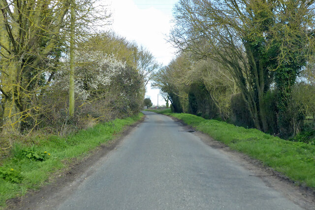
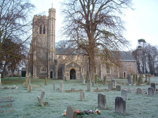
The village is characterized by its charming thatched cottages, historic buildings, and beautiful countryside views. The village center is centered around the village green, which serves as a focal point for community events and gatherings. St. Peter and St. Paul Church, a grade I listed building dating back to the 14th century, stands proudly in the heart of the village.

Brockdish offers a close-knit community atmosphere, with a range of amenities and facilities available to its residents. These include a village hall, a primary school, a post office, and a pub. The village is also home to several small businesses, contributing to the local economy.

Surrounded by rolling farmland and wooded areas, Brockdish offers ample opportunities for outdoor activities such as walking, cycling, and birdwatching. The nearby River Waveney provides opportunities for fishing and boating enthusiasts. The village is also well-positioned for exploring the wider Norfolk countryside and attractions, including the famous Norfolk Broads and the historic market towns of Diss and Harleston.

Overall, Brockdish is a tranquil and picturesque village, offering its residents a peaceful and idyllic rural lifestyle.

If you have any feedback on the listing, please let us know in the comments section below.

Brockdish Images

Images are sourced within 2km of 52.36951/1.248293 or Grid Reference TM2179. Thanks to Geograph Open Source API. All images are credited.

Rural road junction Wingfield Road curves round to the right towards Harleston, but cedes majority to  Hoxne Road coming from the left from the Hoxne, Eye and Diss direction.
Rural road junction
Wingfield Road curves round to the right towards Harleston, but cedes majority to Hoxne Road coming from the left from the Hoxne, Eye and Diss direction.
Converted Mill, Syleham  Old textile mill, converted into dwellings.
Converted Mill, Syleham
Old textile mill, converted into dwellings.
A143 east at turning for The Street to Brockdish
Wingfield Road heading north Towards Needham.
Wingfield Road heading north
Towards Needham.
St.Peter And St.Paul Brockdish The church of St.Peter and St.Paul Brockdish Norfolk on a frosty morning.
<span class="nowrap"><a title="http://www.norfolkchurches.co.uk/brockdish/brockdish.htm" rel="nofollow ugc noopener" href="http://www.norfolkchurches.co.uk/brockdish/brockdish.htm">Link</a><img style="margin-left:2px;" alt="External link" title="External link - shift click to open in new window" src="https://s1.geograph.org.uk/img/external.png" width="10" height="10"/></span>
St.Peter And St.Paul Brockdish
The church of St.Peter and St.Paul Brockdish Norfolk on a frosty morning. LinkExternal link
A view of Grange Farm
'The Old Kings Head' inn The road was the original A.143 that ran through Brockdish village.
'The Old Kings Head' inn
The road was the original A.143 that ran through Brockdish village.
Cottages at Syleham This view is at the end of Wingfield road. The notice board, just to the left of the cottages, stands at the start of a track that leads to Syleham parish church.
Cottages at Syleham
This view is at the end of Wingfield road. The notice board, just to the left of the cottages, stands at the start of a track that leads to Syleham parish church.
Field with crows (rooks) near Syleham Hall
Field near Earsham Street
Hardstanding by the road near Oak Farm
Field Looking towards Syleham Hall
Field
Looking towards Syleham Hall
Footpath heading towards the River Waveney
Barn and garage at Oak farm
Hawthorn Barn, Upper Weybread
Hoxne Road, Syleham
Hoxne Road, Syleham
The Street, Brockdish Much quieter and safer since the village was by-passed.
The Street, Brockdish
Much quieter and safer since the village was by-passed.
The Ford, Brockdish There is an alternative route when the ford is high.
The Ford, Brockdish
There is an alternative route when the ford is high.
Show me another place!

Brockdish is located at Grid Ref: TM2179 (Lat: 52.36951, Lng: 1.248293)

Administrative County: Norfolk

District: South Norfolk

Police Authority: Norfolk

What 3 Words

///magic.ghosts.tinny. Near Harleston, Norfolk

Nearby Locations

Brockdish

Related Wikis

Brockdish

Brockdish is a village and civil parish in the South Norfolk district of Norfolk, England. The village is situated on the River Waveney (south of which...

Thorpe Abbotts

Thorpe Abbotts is a village and (as Thorpe Abbots) a former civil parish, now in the parish of Brockdish, in the South Norfolk district, in the county...

Syleham Windmill

Syleham Windmill was a Grade II listed post mill at Syleham, Suffolk, England which was built in 1730 at Wingfield and moved to Syleham in 1823. It was...

Syleham

Syleham is a small parish, next to the River Waveney in Suffolk, England, about six miles east of Diss. Its church, St Margaret, is one of 38 existing...

Nearby Amenities

Located within 500m of 52.36951,1.248293
Bus Stop
Crabtree Rise, adj
Bench: no
Bin: no
Covered: no
Naptan AtcoCode: 2900B5211
Naptan Bearing: SW
Naptan BusStopType: CUS
Naptan CommonName: Crabtree Rise
Naptan Indicator: adj
Naptan Landmark: Crabtree Rise
Naptan Locality: Brockdish
Naptan NaptanCode: nfoagjtp
Naptan ShortCommonName: Crabtree Rise
Naptan Street: Scole Road
Naptan Verified: yes
Passenger Information Display: no
Physically Present: no
Public Transport: platform
Shelter: no
Source: naptan_import;survey
Tactile Paving: no
Lat/Long: 52.3691014/1.2432998
Bus Stop
Crabtree Rise, opp
Bench: yes
Bin: no
Covered: no
Naptan AtcoCode: 2900B5212
Naptan Bearing: NE
Naptan CommonName: Crabtree Rise
Naptan Indicator: opp
Naptan Landmark: Crabtree Rise
Naptan Locality: Brockdish
Naptan NaptanCode: nfoagjtw
Naptan ShortCommonName: Crabtree Rise
Naptan Street: Scole Road
Naptan Verified: yes
Passenger Information Display: no
Public Transport: platform
Shelter: yes
Source: naptan_import;survey
Tactile Paving: yes
Lat/Long: 52.3690297/1.2434727
Bus Stop
village hall, adj
Bench: yes
Bin: no
Covered: no
Naptan AtcoCode: 2900B525
Naptan Bearing: SW
Naptan BusStopType: CUS
Naptan CommonName: village hall
Naptan Indicator: adj
Naptan Landmark: Grove Road
Naptan Locality: Brockdish
Naptan NaptanCode: nfoagjwg
Naptan ShortCommonName: village hall
Naptan Street: Scole Road
Naptan Verified: yes
Passenger Information Display: no
Physically Present: no
Public Transport: platform
Shelter: no
Source: naptan_import;survey
Tactile Paving: no
Lat/Long: 52.3696412/1.2488215
Bus Stop
village hall, opp
Bench: no
Bin: no
Covered: no
Naptan AtcoCode: 2900B528
Naptan Bearing: NE
Naptan BusStopType: CUS
Naptan CommonName: village hall
Naptan Indicator: opp
Naptan Landmark: Grove Road
Naptan Locality: Brockdish
Naptan NaptanCode: nfoagjwm
Naptan ShortCommonName: village hall
Naptan Street: Scole Road
Naptan Verified: yes
Passenger Information Display: no
Physically Present: no
Public Transport: platform
Shelter: no
Source: naptan_import;survey
Tactile Paving: no
Lat/Long: 52.369742/1.248919
Barrier: stile
Foot: yes
Material: wood
Stile: stepover
Lat/Long: 52.3733453/1.2483429
Bench
Backrest: yes
Material: wood
Seats: 3
Lat/Long: 52.3691839/1.2449902
Ford: yes
Lat/Long: 52.3699562/1.2485683
Traffic Calming: hump
Lat/Long: 52.3690444/1.2508829
Brockdish
Place: village
Lat/Long: 52.3699855/1.247257
Barrier: stile
Foot: yes
Material: wood
Stile: stepover
Lat/Long: 52.37333/1.2483087
Barrier: stile
Foot: yes
Material: wood
Stile: stepover
Lat/Long: 52.3731416/1.247973
Grit Bin
Lat/Long: 52.3691623/1.2438087
Crossing
Crossing: unmarked
Tactile Paving: yes
Lat/Long: 52.3692073/1.2437131
Give Way
Lat/Long: 52.3695372/1.2482867
Give Way
Lat/Long: 52.3700824/1.2486386
Give Way
Lat/Long: 52.3696458/1.2485429
Give Way
Lat/Long: 52.3697291/1.249008
Give Way
Lat/Long: 52.36974/1.2494172
Brockdish
Colour: grey
Inscription: This sign was unveiled on 12 May 1996 by residents Patsy Keeing and Edith Mutimer to mark the opening of this village bypass
Man Made: village_sign
Material: metal
Start Date: 1996-05-12
Lat/Long: 52.369792/1.2485851
Post Box
Collection Times: Mo-Fr 16:45; Sa 11:30
Operator: Royal Mail
Post Box Mounting: pier
Post Box Type: lamp
Ref: IP21 7018
Royal Cypher: EIIR
Royal Cypher Wikidata: Q33102113
Lat/Long: 52.3697396/1.2485663
Bench
Backrest: yes
Colour: brown
Material: wood
Seats: 4
Lat/Long: 52.3697453/1.2486079
Waste Basket
Source: survey
Lat/Long: 52.3691856/1.2449603
Waste Basket
Source: survey
Lat/Long: 52.3692069/1.2435683
Defibrillator
Defibrillator Location: On exterior wall of Brockdish Village Hall
Emergency: defibrillator
Indoor: no
Ref GB The Circuit: 0601C47C-111F-44CC-8545-AD6E00E031C2
Lat/Long: 52.3696128/1.248895
Power: pole
Lat/Long: 52.3668716/1.2542224
Power: pole
Lat/Long: 52.3674784/1.2548125
Power: pole
Lat/Long: 52.368565/1.2550955
Power: pole
Lat/Long: 52.3691848/1.2545953
Barrier: bollard
Foot: yes
Lat/Long: 52.3691765/1.2432991
Waste Basket
Waste: dog_excrement
Lat/Long: 52.3697492/1.2488992
Description: The Angles Way
Hiking: yes
Information: route_marker
Tourism: information
Lat/Long: 52.3694948/1.248238
Hiking: yes
Information: map
Tourism: information
Lat/Long: 52.3697119/1.2487024
Board Type: nature
Information: board
Tourism: information
Lat/Long: 52.3697122/1.2486825
Telephone
Booth: K6
Covered: booth
Listed Status: Grade II
Wikidata: Q26544544
Lat/Long: 52.3696004/1.248751
Waste Basket
Waste: trash
Lat/Long: 52.3697478/1.2485696
Covered: no
Leisure: picnic_table
Lat/Long: 52.3698256/1.2486427
Recycling
Recycling Clothes: yes
Recycling Type: container
Lat/Long: 52.3695353/1.2489961
Barrier: bollard
Foot: yes
Lat/Long: 52.3689579/1.2506212
Waste Basket
Waste: dog_excrement
Lat/Long: 52.3689441/1.2506155
Bench
Backrest: no
Material: wood
Lat/Long: 52.368633/1.2505015
Bench
Backrest: no
Material: wood
Lat/Long: 52.3691672/1.2500187
Covered: no
Leisure: picnic_table
Lat/Long: 52.3683791/1.2519633
Description: Angles Way
Hiking: yes
Information: route_marker
Tourism: information
Lat/Long: 52.3688323/1.2526687
Bench
Backrest: yes
Material: wood
Lat/Long: 52.3696088/1.2488244
Waste Basket
Waste: trash
Lat/Long: 52.3696037/1.2487668
Barrier: cycle_barrier
Foot: yes
Lat/Long: 52.3693652/1.2433128
Waste Basket
Waste: dog_excrement
Lat/Long: 52.3713124/1.2523066
Waterway: weir
Lat/Long: 52.3660302/1.2492194
Power: pole
Lat/Long: 52.3692733/1.2535022
Power: pole
Lat/Long: 52.3692938/1.2498893
Power: pole
Lat/Long: 52.3688065/1.250132
Power: pole
Lat/Long: 52.3688974/1.2512398
Power: pole
Lat/Long: 52.3690465/1.2520961
Power: pole
Lat/Long: 52.3696944/1.2465647
Power: pole
Lat/Long: 52.3701612/1.2455211
Power: pole
Lat/Long: 52.3706436/1.2444427
Power: pole
Lat/Long: 52.3705619/1.2433283
Power: pole
Lat/Long: 52.3704852/1.2422825
Power: pole
Lat/Long: 52.3711455/1.2415355
Board Type: nature
Information: board
Tourism: information
Lat/Long: 52.3693007/1.2497907
The data included in this document is from www.openstreetmap.org. The data is made available under ODbL.

Have you been to Brockdish?

Leave your review of Brockdish below (or comments, questions and feedback).