Eyeworth

Civil Parish in Bedfordshire

England

Eyeworth

Parish church, Dunton, Beds View from Chapel St from the south; dedicated to St Mary Magdalene, the stone building is in the Early English, Decorated and Perpendicular styles, consisting of chancel, nave of four bays, aisles, and an embattled western tower, containing 5 bells (hung in 1887 in commemoration of the jubilee of Queen Victoria), and south porch.
Parish church, Dunton, Beds Credit: Rodney Burton

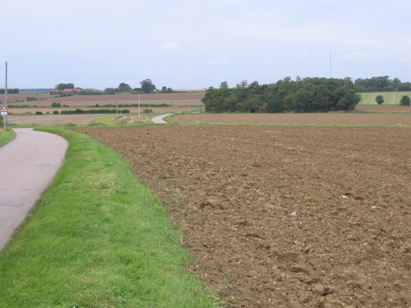
Eyeworth is a civil parish located in the county of Bedfordshire, England. It is situated in the southern part of the county, close to the border with Hertfordshire. The parish covers an area of approximately 4 square miles and is mainly rural in nature. It is surrounded by beautiful countryside, with rolling hills, meadows, and woodlands.

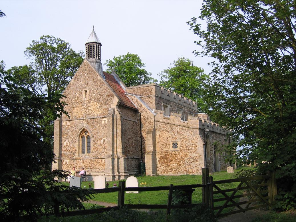
Eyeworth is a small village within the civil parish and is home to a population of around 200 residents. The village has a charming and picturesque setting, with a mix of traditional stone cottages and newer houses. The village church, St. Mary's, is a notable landmark, dating back to the 12th century and featuring a unique octagonal tower.

Despite its small size, Eyeworth has a strong sense of community and offers a range of amenities and activities for its residents. These include a village hall, a primary school, and a local pub. The village hall hosts various events and social gatherings throughout the year, providing a hub for the community to come together.

The surrounding area of Eyeworth is a haven for nature lovers and outdoor enthusiasts. The parish is located near the Chiltern Hills Area of Outstanding Natural Beauty, offering opportunities for walking, hiking, and exploring the local flora and fauna. The nearby Greensand Ridge is also popular for outdoor activities.

Overall, Eyeworth is a charming and tranquil civil parish, offering a peaceful and idyllic lifestyle in the heart of the Bedfordshire countryside.

If you have any feedback on the listing, please let us know in the comments section below.

Eyeworth Images

Images are sourced within 2km of 52.091524/-0.17261 or Grid Reference TL2545. Thanks to Geograph Open Source API. All images are credited.

Parish church, Dunton, Beds View from Chapel St from the south; dedicated to St Mary Magdalene, the stone building is in the Early English, Decorated and Perpendicular styles, consisting of chancel, nave of four bays, aisles, and an embattled western tower, containing 5 bells (hung in 1887 in commemoration of the jubilee of Queen Victoria), and south porch.
Parish church, Dunton, Beds
View from Chapel St from the south; dedicated to St Mary Magdalene, the stone building is in the Early English, Decorated and Perpendicular styles, consisting of chancel, nave of four bays, aisles, and an embattled western tower, containing 5 bells (hung in 1887 in commemoration of the jubilee of Queen Victoria), and south porch.
Village sign, Dunton, Beds
Dangerous bends, Eyeworth, Beds A dangerous double bend on the road between Eyeworth and Wrestlingworth has been the scene of many accidents. The landscape of the chalky boulder clay plateau is fairly open with long gentle slopes.
Dangerous bends, Eyeworth, Beds
A dangerous double bend on the road between Eyeworth and Wrestlingworth has been the scene of many accidents. The landscape of the chalky boulder clay plateau is fairly open with long gentle slopes.
All Saints' Church, Eyeworth, Beds Church in the Early English Style with neatly tended churchyard.
All Saints' Church, Eyeworth, Beds
Church in the Early English Style with neatly tended churchyard.
Dunton Water Works, Beds
Sutton Road, Eyeworth, Beds View NW towards a wide shallow valley on the Chalky Boulder Clay plateau.
Sutton Road, Eyeworth, Beds
View NW towards a wide shallow valley on the Chalky Boulder Clay plateau.
View towards Manor Farm, Wrestlingworth, Beds
Farmland S of Wrestlingworth, Beds View N from the plateau towards the B1042 Tadlow Road and the crossroads.
Farmland S of Wrestlingworth, Beds
View N from the plateau towards the B1042 Tadlow Road and the crossroads.
Hook's Mill, Guilden Morden, Cambs a tower mill of tarred brick with ogee cap missing, built 1865; on the right is Hook's late 18th cent. water mill and engine house with a tall tapering rectangular chimney stack, last used 1935 and Grade II listed.
Hook's Mill, Guilden Morden, Cambs
a tower mill of tarred brick with ogee cap missing, built 1865; on the right is Hook's late 18th cent. water mill and engine house with a tall tapering rectangular chimney stack, last used 1935 and Grade II listed.
Potton Road, Guilden Morden, Cambs view NW towards the bridge over the River Cam or Rhee.
Potton Road, Guilden Morden, Cambs
view NW towards the bridge over the River Cam or Rhee.
Guilden Morden Road, Wrestlingworth, Beds view NW across the Gault clay valley of the Cam towards the Chalky Boulder Clay-capped plateau.
Guilden Morden Road, Wrestlingworth, Beds
view NW across the Gault clay valley of the Cam towards the Chalky Boulder Clay-capped plateau.
Beds-Cambs county boundary, Wrestlingworth one large arable field has resulted from the amalgamation of many small ones, but the unrationalised county boundary still follows the old field boundaries with many angular bends.
Beds-Cambs county boundary, Wrestlingworth
one large arable field has resulted from the amalgamation of many small ones, but the unrationalised county boundary still follows the old field boundaries with many angular bends.
Cottages, Eyeworth, Beds located at the NE end of this small settlement, beside the road to Wrestlingworth.
Cottages, Eyeworth, Beds
located at the NE end of this small settlement, beside the road to Wrestlingworth.
Manor Farm House, Eyeworth, Beds on the High Street.
Manor Farm House, Eyeworth, Beds
on the High Street.
Farmland
Farmland
Cyclists on a road near Eyeworth Lodge Farm
Cyclists and an impatient car driver depart.
Show me another place!

Eyeworth is located at Grid Ref: TL2545 (Lat: 52.091524, Lng: -0.17261)

Unitary Authority: Central Bedfordshire

Police Authority: Bedfordshire

What 3 Words

///stump.overt.drama. Near Sutton, Bedfordshire

Nearby Locations

Eyeworth Eyeworth

Related Wikis

Eyeworth

Eyeworth (also Eyworth) is a small, rural village and civil parish in the Central Bedfordshire district of the county of Bedfordshire, England; about 12...

Dunton, Bedfordshire

Dunton is a village and civil parish in the Central Bedfordshire district of the county of Bedfordshire, England; about 12 miles (19 km) east south-east...

Church of St Peter, Wrestlingworth

Church of St Peter is a Grade I listed church in Wrestlingworth, Bedfordshire, England. It became a listed building on 31 October 1966. == See also... ==

Wrestlingworth

Wrestlingworth is a village and former civil parish, now in the parish of Wrestlingworth and Cockayne Hatley, in the Central Bedfordshire district of the...

Nearby Amenities

Located within 500m of 52.091524,-0.17261
The data included in this document is from www.openstreetmap.org. The data is made available under ODbL.

Have you been to Eyeworth?

Leave your review of Eyeworth below (or comments, questions and feedback).