Ellesmere Urban

Civil Parish in Shropshire

England

Ellesmere Urban

Ellesmere Bowling Club The lower of two greens on the motte of Ellesmere Castle.
Ellesmere Bowling Club Credit: Richard Webb

Ellesmere Urban is a civil parish located in the county of Shropshire, England. It is situated near the border with Wales, approximately 15 miles northwest of the town of Shrewsbury. Ellesmere is a small market town that lies on the banks of the picturesque Ellesmere Canal and the largest of the nine lakes known as The Mere.

The town has a rich history, with evidence of human habitation dating back to the Mesolithic period. Ellesmere played a significant role in the medieval wool trade and was granted a market charter in 1221. The town grew in importance during the Industrial Revolution, with the construction of the Ellesmere Canal in the late 18th century, which facilitated transportation of goods and boosted the local economy.

Today, Ellesmere Urban is a charming and vibrant town, attracting visitors with its natural beauty and historical landmarks. The Mere is a popular destination for boating, fishing, and wildlife watching, offering a tranquil escape for residents and tourists alike. The town center is home to a variety of independent shops, cafes, and traditional pubs, providing a welcoming atmosphere for locals.

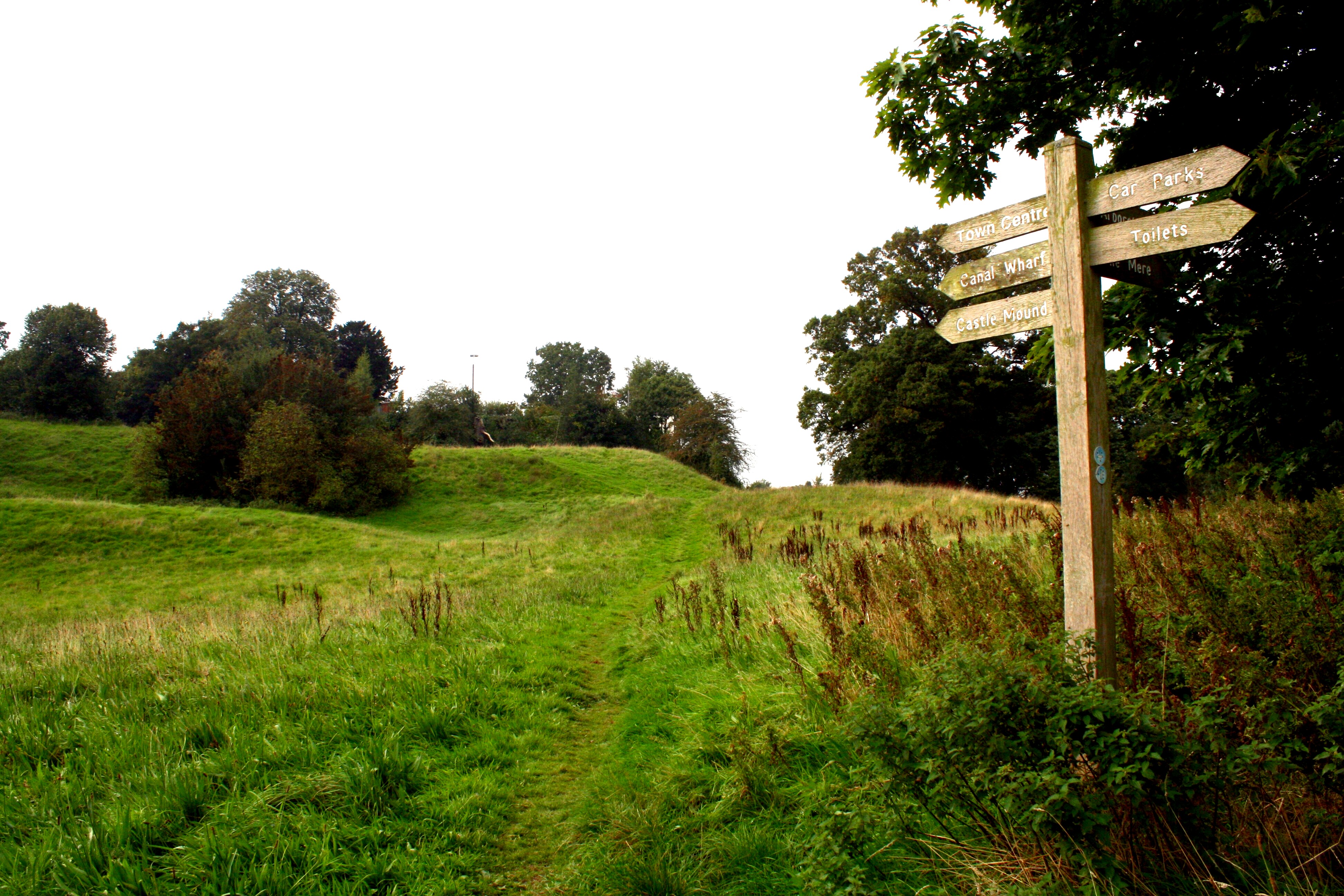
Ellesmere Urban also boasts several notable landmarks, including St. Mary's Church, a Grade I listed building dating back to the 15th century, and the Ellesmere Castle, a motte-and-bailey castle built in the 12th century. The town hosts an annual festival called Ellesmere Carnival, which features a parade, live music, and various entertainment activities.

With its idyllic countryside setting and rich heritage, Ellesmere Urban offers a delightful experience for visitors seeking a taste of traditional English life.

If you have any feedback on the listing, please let us know in the comments section below.

Ellesmere Urban Images

Images are sourced within 2km of 52.912484/-2.894179 or Grid Reference SJ3935. Thanks to Geograph Open Source API. All images are credited.

Ellesmere Bowling Club The lower of two greens on the motte of Ellesmere Castle.
Ellesmere Bowling Club
The lower of two greens on the motte of Ellesmere Castle.
Top of Ellesmere Castle motte The site of Ellesmere Castle, now a bowling green.
Top of Ellesmere Castle motte
The site of Ellesmere Castle, now a bowling green.
Churchyard, Ellesmere
Church Street, Ellesmere
Parkland. Oteley Taken from a road junction with a demolished sign.
Parkland. Oteley
Taken from a road junction with a demolished sign.
Hill top enclosure Parkland with grazing Highland cattle.
Hill top enclosure
Parkland with grazing Highland cattle.
Ordnance Survey Cut Mark This OS cut mark can be found on the stone gatepost east side of the road. It marks a point 92.796m above mean sea level.
Ordnance Survey Cut Mark
This OS cut mark can be found on the stone gatepost east side of the road. It marks a point 92.796m above mean sea level.
Ordnance Survey Rivet This OS rivet can be found on the kerb in front of Ellesmere House. It marks a point 93.384m above mean sea level.
Ordnance Survey Rivet
This OS rivet can be found on the kerb in front of Ellesmere House. It marks a point 93.384m above mean sea level.
A528 east of Ellesmere The Shropshire Way suddenly morphs from the tranquility of canal towpaths onto this busy main road. Fortunately for only a small stretch.
A528 east of Ellesmere
The Shropshire Way suddenly morphs from the tranquility of canal towpaths onto this busy main road. Fortunately for only a small stretch.
Motte and Bailey at Ellesmere Originally build in the late 11th century, this impressive mound still imposes its presence overlooking the Mere.
Motte and Bailey at Ellesmere
Originally build in the late 11th century, this impressive mound still imposes its presence overlooking the Mere.
Spur of Llangollen Canal at Ellesmere Back on the main canal, the left hand fork goes west towards Whitchurch, whilst the right hand heads down to Llanymynech. Both directions mark the Shropshire Way walking trail. A footbridge crosses here, giving a great vantage point to watch the comings and goings of canal boats and pedestrians.
Spur of Llangollen Canal at Ellesmere
Back on the main canal, the left hand fork goes west towards Whitchurch, whilst the right hand heads down to Llanymynech. Both directions mark the Shropshire Way walking trail. A footbridge crosses here, giving a great vantage point to watch the comings and goings of canal boats and pedestrians.
Marina at Ellesmere Looks quiet today, but plenty of boats moored up and some being serviced and repaired.
Marina at Ellesmere
Looks quiet today, but plenty of boats moored up and some being serviced and repaired.
Building development on the fringe of Ellesmere A good number of lodges being built along the side of the Llangollen Canal. They are wooden prefabs, and could be holiday or permanent accommodation. Lovely location so I’m sure they’ll be very popular.
Building development on the fringe of Ellesmere
A good number of lodges being built along the side of the Llangollen Canal. They are wooden prefabs, and could be holiday or permanent accommodation. Lovely location so I’m sure they’ll be very popular.
A495 alongside The Mere
The Mere at Ellesmere View from pleasant footpath between road and lake.
The Mere at Ellesmere
View from pleasant footpath between road and lake.
The Bee "Metropolis" A small enclosure close to the Mere,  dedicated to the welfare of wild bees by providing plentiful wild flowers and opportunities for nest building.
The Bee "Metropolis"
A small enclosure close to the Mere, dedicated to the welfare of wild bees by providing plentiful wild flowers and opportunities for nest building.
Crimps Cottages
Crimps Cottages
Show me another place!

Ellesmere Urban is located at Grid Ref: SJ3935 (Lat: 52.912484, Lng: -2.894179)

Unitary Authority: Shropshire

Police Authority: West Mercia

What 3 Words

///shallower.speaking.science. Near Ellesmere, Shropshire

Nearby Locations

Ellesmere Urban

Related Wikis

Ellesmere, Shropshire

Ellesmere ( ELZ-meer) is a town in the civil parish of Ellesmere Urban, in Shropshire, England, located near the Welsh border and the towns of Oswestry...

Ellesmere railway station

Ellesmere railway station is a disused station in Ellesmere, Shropshire, England. The station was opened on 4 May 1863, closed to passengers on 18 January...

Old Town Hall, Ellesmere

The Old Town Hall is a municipal building in the High Street in Ellesmere, Shropshire, England. The structure, which was the meeting place of Ellesmere...

St Mary's Church, Ellesmere

St Mary's Church stands on a hill in the town of Ellesmere, Shropshire, England. It is an active Anglican parish church in the deanery of Ellesmere, the...

Ellesmere Castle

Ellesmere Castle was in the town of Ellesmere, Shropshire. (grid reference SJ403347).This was a motte and bailey castle which was probably founded by Roger...

Ellesmere Rangers F.C.

Ellesmere Rangers Football Club is a football club based in Ellesmere, Shropshire, England. They are currently members of the Shropshire County League...

Lakelands Academy

Lakelands Academy (formerly The Lakelands School) is a coeducational secondary school located in Ellesmere in the English county of Shropshire.Previously...

Elson Halt railway station

Elson Halt railway station was a station to the northwest of Ellesmere, Shropshire, England. The station was opened in 1937 and finally closed in 1962...

Nearby Amenities

Located within 500m of 52.912484,-2.894179
Ellesmere Crossroads
Bus: yes
Public Transport: stop_position
Lat/Long: 52.9088366/-2.8934859
Turning Circle
Lat/Long: 52.9083262/-2.8960241
Turning Circle
Lat/Long: 52.9097135/-2.8938373
Turning Circle
Turning Circle: knuckle
Lat/Long: 52.9126988/-2.8913165
Turning Circle
Lat/Long: 52.9136107/-2.8893855
Post Box
Collection Times: Mo-Fr 17:30; Sa 10:00
Post Box Type: wall
Ref: SY12 1
Royal Cypher: VR
Royal Cypher Wikidata: Q33102356
Lat/Long: 52.9088415/-2.8934231
Toilets
Lat/Long: 52.9101817/-2.8899585
Post Box
Post Box Type: lamp
Ref: SY12 18
Royal Cypher: EIIR
Royal Cypher Wikidata: Q33102113
Lat/Long: 52.9103951/-2.8915678
Bus Stop
adj Ellesmere Crossroads
Bus: yes
Naptan AtcoCode: 3500B267100
Naptan NaptanCode: shrawdgd
Public Transport: platform
Shelter: yes
Lat/Long: 52.9088596/-2.8936764
Power: pole
Lat/Long: 52.9137416/-2.9000017
Power: pole
Lat/Long: 52.9131011/-2.899645
Power: pole
Lat/Long: 52.9125399/-2.8993338
Power: pole
Lat/Long: 52.9122228/-2.8985453
Power: pole
Lat/Long: 52.9124768/-2.900734
Power: pole
Lat/Long: 52.9122115/-2.8995296
Power: pole
Lat/Long: 52.9114853/-2.8977191
Power: pole
Lat/Long: 52.9113413/-2.8985667
Power: pole
Lat/Long: 52.9114562/-2.9002377
Historic: archaeological_site
Source: NLS-OS-1st_Series
Lat/Long: 52.912285/-2.8897421
Power: pole
Lat/Long: 52.9150742/-2.8891899
Power: pole
Lat/Long: 52.9124928/-2.8953616
Power: pole
Lat/Long: 52.9129004/-2.8944202
Power: pole
Lat/Long: 52.9138514/-2.8921671
Power: pole
Lat/Long: 52.9144482/-2.8907375
Generator Method: photovoltaic
Generator Output Electricity: yes
Generator Source: solar
Generator Type: solar_photovoltaic_panel
Location: roof
Power: generator
Lat/Long: 52.9122115/-2.8906757
Generator Method: photovoltaic
Generator Output Electricity: yes
Generator Source: solar
Generator Type: solar_photovoltaic_panel
Location: roof
Power: generator
Lat/Long: 52.9133179/-2.890445
Generator Method: photovoltaic
Generator Output Electricity: yes
Generator Source: solar
Generator Type: solar_photovoltaic_panel
Location: roof
Power: generator
Lat/Long: 52.9112491/-2.8935215
Generator Method: photovoltaic
Generator Output Electricity: yes
Generator Source: solar
Generator Type: solar_photovoltaic_panel
Location: roof
Power: generator
Lat/Long: 52.9094957/-2.8924567
Generator Method: photovoltaic
Generator Output Electricity: yes
Generator Source: solar
Generator Type: solar_photovoltaic_panel
Location: roof
Power: generator
Lat/Long: 52.9104905/-2.8939775
Generator Method: photovoltaic
Generator Output Electricity: yes
Generator Source: solar
Generator Type: solar_photovoltaic_panel
Location: roof
Power: generator
Lat/Long: 52.9102527/-2.8935242
Man Made: pumping_station
Lat/Long: 52.9159082/-2.8968874
Crossing
Crossing: uncontrolled
Crossing Island: no
Crossing Markings: yes
Tactile Paving: yes
Traffic Calming: choker
Lat/Long: 52.9111024/-2.8946496
Give Way
Direction: forward
Lat/Long: 52.9110271/-2.8946703
Barrier: kerb
Kerb: flush
Tactile Paving: yes
Lat/Long: 52.9090534/-2.8940734
Barrier: kerb
Kerb: flush
Tactile Paving: yes
Lat/Long: 52.9089477/-2.8939747
Crossing
Crossing: unmarked
Crossing Island: no
Crossing Markings: no
Tactile Paving: yes
Lat/Long: 52.9089575/-2.8936842
Barrier: cycle_barrier
Lat/Long: 52.9088887/-2.893823
Barrier: kerb
Kerb: flush
Tactile Paving: yes
Lat/Long: 52.9089469/-2.8937056
Crossing
Crossing: unmarked
Crossing Island: yes
Crossing Markings: no
Tactile Paving: yes
Lat/Long: 52.9089817/-2.8940043
Crossing
Crossing: unmarked
Crossing Island: yes
Crossing Markings: no
Tactile Paving: yes
Lat/Long: 52.9091586/-2.893964
Barrier: kerb
Kerb: flush
Tactile Paving: yes
Lat/Long: 52.9091395/-2.8940341
Crossing
Crossing: unmarked
Crossing Island: no
Crossing Markings: no
Tactile Paving: yes
Lat/Long: 52.9091503/-2.893593
Man Made: tower
Lat/Long: 52.9101342/-2.8942584
Give Way
Direction: forward
Lat/Long: 52.908824/-2.8943303
Restaurant
Meze Restaurant Ellesmere
Addr City: Ellesmere
Addr Country: GB
Addr Housenumber: 31
Addr Postcode: SY12 0AW
Addr Street: Cross Street
Fhrs Authority: Shropshire
Fhrs Id: 1246776
Fhrs Local Authority Id: 19/00582/COMM
Lat/Long: 52.9082683/-2.8930863
The data included in this document is from www.openstreetmap.org. The data is made available under ODbL.

Have you been to Ellesmere Urban?

Leave your review of Ellesmere Urban below (or comments, questions and feedback).