Easington

Civil Parish in Yorkshire Ribble Valley

England

Easington

View of Forest of Bowland from near Stocks Reservoir The view shows the River Hodder just after it flows into the Stocks reservoir. It flows south to join the River Ribble. The hills in the distance are part of the Forest of Bowland
View of Forest of Bowland from near Stocks Reservoir Credit: Rod Grealish

Easington is a civil parish located in the East Riding of Yorkshire, England. Situated on the Holderness coast, it is approximately 10 miles northeast of the city of Hull. The parish covers an area of around 10 square miles and is home to a population of approximately 1,200 residents.

Easington is a rural area known for its picturesque landscapes and natural beauty. It is surrounded by fertile farmland and offers stunning views of the North Sea. The coastal area is protected by a series of sea defenses, which help to prevent erosion and maintain the integrity of the shoreline.

The village of Easington itself is a small and close-knit community. It has a range of amenities and services to cater to the needs of its residents, including a primary school, a village hall, a post office, and a pub. The village also has a rich history, with evidence of human settlement dating back to the Neolithic period.

Easington is located close to several popular tourist attractions, including the Spurn National Nature Reserve. This unique nature reserve is a haven for wildlife, offering opportunities for birdwatching and nature walks. Additionally, the nearby city of Hull provides further amenities, cultural attractions, and shopping opportunities.

Overall, Easington is a peaceful and idyllic parish, ideal for those seeking a rural lifestyle with easy access to both natural beauty and urban conveniences.

If you have any feedback on the listing, please let us know in the comments section below.

Easington Images

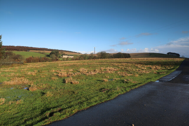
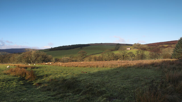
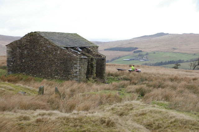
Images are sourced within 2km of 54.012767/-2.41126 or Grid Reference SD7357. Thanks to Geograph Open Source API. All images are credited.

View of Forest of Bowland from near Stocks Reservoir The view shows the River Hodder just after it flows into the Stocks reservoir. It flows south to join the River Ribble. The hills in the distance are part of the Forest of Bowland
View of Forest of Bowland from near Stocks Reservoir
The view shows the River Hodder just after it flows into the Stocks reservoir. It flows south to join the River Ribble. The hills in the distance are part of the Forest of Bowland
River Hodder entering Stocks Reservoir The photo shows the point at which the River Hodder enters the Stocks Reservoir. The reservoir is at a particularly low level. It was opened in 1932 and supplies Blackpool and the Fylde coast. There are a number of waymarked forest walks and cycle routes. Trout fishing is available.
River Hodder entering Stocks Reservoir
The photo shows the point at which the River Hodder enters the Stocks Reservoir. The reservoir is at a particularly low level. It was opened in 1932 and supplies Blackpool and the Fylde coast. There are a number of waymarked forest walks and cycle routes. Trout fishing is available.
Looking over Coat Rakes to Dale House Dale House is just by the road north from Gisburn Forest towards Clapham in the Yorkshire Dales. The track here goes to Halsteads Farm, whilst a rougher track to the right goes to Cocklick End, not a place to mention in social media posts, as an AI is likely to take exception...
Looking over Coat Rakes to Dale House
Dale House is just by the road north from Gisburn Forest towards Clapham in the Yorkshire Dales. The track here goes to Halsteads Farm, whilst a rougher track to the right goes to Cocklick End, not a place to mention in social media posts, as an AI is likely to take exception...
Higher Clough On the west side of the Keasden road, land rises to Green Pike above Higher Clough (the farmhouse in the sun). The moor on the far horizon is CROW Access Land, but most of what is visible in this view has no public access.
Higher Clough
On the west side of the Keasden road, land rises to Green Pike above Higher Clough (the farmhouse in the sun). The moor on the far horizon is CROW Access Land, but most of what is visible in this view has no public access.
Gisburn Forest track A left turn to the north makes this easy-going teack a little harder as it is now gently uphill. Most of the forestry tracks are like this - low gradient and not too challenging for those on mountain bikes so old that suspension was not deemed necessary (at my age I want all the power I can generate to go into actual forward progress, not into compressing shock absorbers).
Gisburn Forest track
A left turn to the north makes this easy-going teack a little harder as it is now gently uphill. Most of the forestry tracks are like this - low gradient and not too challenging for those on mountain bikes so old that suspension was not deemed necessary (at my age I want all the power I can generate to go into actual forward progress, not into compressing shock absorbers).
Looking over Bottoms Beck A gap in the trees to the east of the track allows a view over Bottoms Beck to the clearing morning mists towards Hesbert Hall.
Looking over Bottoms Beck
A gap in the trees to the east of the track allows a view over Bottoms Beck to the clearing morning mists towards Hesbert Hall.
Hesbert Hall The forest track runs alongside a seriously thistle-infested field at Hesbert Hall with the extensive Gisburn Forest surrounding it - a few colouring larches, but mostly evergreen non-native conifers (Sitka spruce, Picea sitchensis, being the majority).
Hesbert Hall
The forest track runs alongside a seriously thistle-infested field at Hesbert Hall with the extensive Gisburn Forest surrounding it - a few colouring larches, but mostly evergreen non-native conifers (Sitka spruce, Picea sitchensis, being the majority).
Tiny stream in Gisburn Forest A public footpath leaves School Lane to head northwest into the forest, but is scarcely visible on the ground. Crossing this stream, it climbs the muddy bank above to meet a recently made decent path, where the public right of way follows it for a short while towards Stocks reservoir before resuming its course into the forest and becoming totally vague once more. The new path also continues northeast, not a right of way but clearly much more frequented than the public footpath itself. Downhill, the new path passes into the open near the shore of the reservoir, and quite close to the car park at the corner of School Lane.
Tiny stream in Gisburn Forest
A public footpath leaves School Lane to head northwest into the forest, but is scarcely visible on the ground. Crossing this stream, it climbs the muddy bank above to meet a recently made decent path, where the public right of way follows it for a short while towards Stocks reservoir before resuming its course into the forest and becoming totally vague once more. The new path also continues northeast, not a right of way but clearly much more frequented than the public footpath itself. Downhill, the new path passes into the open near the shore of the reservoir, and quite close to the car park at the corner of School Lane.
Bird hide above the shore of Stocks Reservoir Tucked away on the edge of the forest, overlooking the shore of Stocks Reservoir, United Utilities have provided this and at least one other wildlife hide. It really is quite well concealed, whilst offering a clear view over many geese at the upstream end of the water (at least today). A barbed wire fence effectively deters one from getting any closer to the water, or, indeed, getting a clearer picture of the hide itself.
Bird hide above the shore of Stocks Reservoir
Tucked away on the edge of the forest, overlooking the shore of Stocks Reservoir, United Utilities have provided this and at least one other wildlife hide. It really is quite well concealed, whilst offering a clear view over many geese at the upstream end of the water (at least today). A barbed wire fence effectively deters one from getting any closer to the water, or, indeed, getting a clearer picture of the hide itself.
Footpath to White Hill House A small car park on a corner of School Lane (room for four cars, maybe five if carefully packed) serves this rather wet and muddy footpath heading into Gisburn Forest. The forest is popular with off-road cyclists, but this trail is one of those explicitly signed with a cycling prohibition which suited me fine - I wanted a nice wide track, thanks, and headed a little further south for my ride.
Footpath to White Hill House
A small car park on a corner of School Lane (room for four cars, maybe five if carefully packed) serves this rather wet and muddy footpath heading into Gisburn Forest. The forest is popular with off-road cyclists, but this trail is one of those explicitly signed with a cycling prohibition which suited me fine - I wanted a nice wide track, thanks, and headed a little further south for my ride.
No School - School Lane No sign of a school in sight!  This just seems to be a pleasant forest drive!
No School - School Lane
No sign of a school in sight! This just seems to be a pleasant forest drive!
Micro Forest Moss atop a stone wall reminded me of a miniature forest!
Micro Forest
Moss atop a stone wall reminded me of a miniature forest!
Down School Lane Looking down School Lane towards the Stocks Reservoir.
Down School Lane
Looking down School Lane towards the Stocks Reservoir.
Path in the Forest of Bowland
Mossy Logs in the Forest of Bowland
Stocks Reservoir from near the Bird Hide
Looking out over Stocks Reservoir, Forest of Bowland Lovely view, great place to go Mountain Biking or Horse Riding on purpose-built trails
Looking out over Stocks Reservoir, Forest of Bowland
Lovely view, great place to go Mountain Biking or Horse Riding on purpose-built trails
Brunton Laithe Taken from the SE side of the Laithe looking N. Catlow Farm can be seen in the distance
Brunton Laithe
Taken from the SE side of the Laithe looking N. Catlow Farm can be seen in the distance
Show me another place!

Easington is located at Grid Ref: SD7357 (Lat: 54.012767, Lng: -2.41126)

Division: West Riding

Administrative County: Lancashire

District: Ribble Valley

Police Authority: Lancashire

What 3 Words

///weedy.mulls.smothered. Near Settle, North Yorkshire

Nearby Locations

Easington

Related Wikis

Easington, Lancashire

Easington () is a civil parish within the Ribble Valley district of Lancashire, England, with a population in 2001 of 52. The Census 2011 population details...

Stocks Reservoir

Stocks Reservoir is a reservoir situated at the head of the Hodder valley in the Forest of Bowland, Lancashire, England (historically in the West Riding...

Tosside

Tosside is a small village on the modern border of North Yorkshire and Lancashire in Northern England. It lies within the Forest of Bowland, and is between...

Gisburn Forest

Gisburn Forest is a civil parish in the Ribble Valley, in Lancashire, England. Mainly lying within the Forest of Bowland Area of Outstanding Natural Beauty...

Have you been to Easington?

Leave your review of Easington below (or comments, questions and feedback).