Defford

Civil Parish in Worcestershire Wychavon

England

Defford

The old main road The old A4104 has now become a parking lot and storage space at this end. Still a right of way, but barely accessible over a large mound of earth.
The old main road Credit: Trevor Rickard

Defford is a civil parish located in Worcestershire, England. Situated approximately 6 miles southeast of the city of Worcester, Defford is a rural village with a population of around 500 residents. The parish covers an area of about 6 square miles and is bordered by the River Avon to the east.

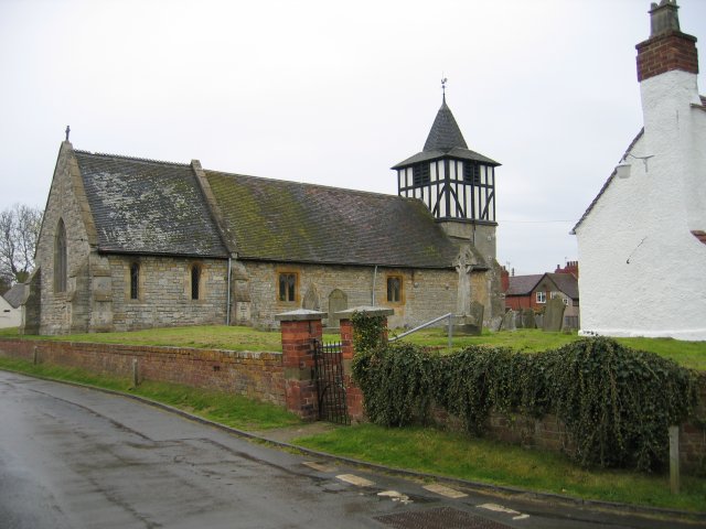
Defford is known for its picturesque countryside, with rolling hills, farmland, and meandering streams. The village itself is characterized by a mix of traditional stone cottages and more modern houses. It has a small but active community, with several local amenities including a village hall, a primary school, and a pub.

One of the notable landmarks in Defford is the Defford Airfield, which was originally established as a Royal Air Force (RAF) base during World War II. Today, the airfield is privately owned and used for private aviation and gliding activities.

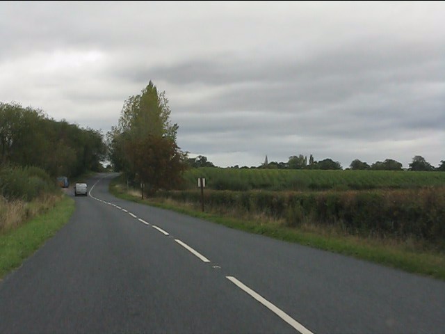
The village is well-connected by road, with the A4104 passing through Defford, providing easy access to nearby towns and cities. The nearby Pershore railway station also offers convenient rail links to Worcester, Birmingham, and other major cities.

Defford is surrounded by beautiful countryside, making it an attractive destination for outdoor enthusiasts. The area offers numerous walking and cycling routes, providing opportunities to explore the stunning Worcestershire landscape. Additionally, the nearby Bredon Hill provides panoramic views and is a popular spot for hiking and picnicking.

Overall, Defford is a charming and tranquil village, offering a peaceful rural lifestyle while still being within easy reach of urban amenities.

If you have any feedback on the listing, please let us know in the comments section below.

Defford Images

Images are sourced within 2km of 52.087395/-2.135321 or Grid Reference SO9043. Thanks to Geograph Open Source API. All images are credited.

The old main road The old A4104 has now become a parking lot and storage space at this end. Still a right of way, but barely accessible over a large mound of earth.
The old main road
The old A4104 has now become a parking lot and storage space at this end. Still a right of way, but barely accessible over a large mound of earth.
Landing strip near Woodmancote This marker denotes the eastern end of the private grass landing strip to the north of the village. Large barns serving as hangars on the left. The Malvern Hills in the distance (the Worcestershire Beacon is just above the wind sock).
See <a href="https://www.geograph.org.uk/photo/2448255">SO9043 : Landing strip near Woodmancote</a> for the reverse view.
Landing strip near Woodmancote
This marker denotes the eastern end of the private grass landing strip to the north of the village. Large barns serving as hangars on the left. The Malvern Hills in the distance (the Worcestershire Beacon is just above the wind sock). See SO9043 : Landing strip near Woodmancote for the reverse view.
Farm track near Defford Heading east with Bredon Hill on the right. The landowner here kindly allows access along several permitted pathways, not just the public rights of ways like this one.
Farm track near Defford
Heading east with Bredon Hill on the right. The landowner here kindly allows access along several permitted pathways, not just the public rights of ways like this one.
Path to woodland near Porter's Ashbed Looking north-west to an isolated wood near the Defford airfield. The landowner kindly allows access to this wood and several other private paths nearby. The public footpath ends at the corner of the wood, but a sign there reads "Visitors are permitted to enjoy this space, so long as dogs are kept under control and no wildlife, timber or flora are disturbed. No horse riding or motor vehicles please". I found the area most relaxing and at this time of year there are bluebells flowering in the wood.
Path to woodland near Porter's Ashbed
Looking north-west to an isolated wood near the Defford airfield. The landowner kindly allows access to this wood and several other private paths nearby. The public footpath ends at the corner of the wood, but a sign there reads "Visitors are permitted to enjoy this space, so long as dogs are kept under control and no wildlife, timber or flora are disturbed. No horse riding or motor vehicles please". I found the area most relaxing and at this time of year there are bluebells flowering in the wood.
Seat at the end of the landing strip At the west end of the light aircraft landing strip is a seat with a view across flat farmland to the Malvern Hills.
Seat at the end of the landing strip
At the west end of the light aircraft landing strip is a seat with a view across flat farmland to the Malvern Hills.
Landing strip near Woodmancote View east from the end of the grass runway. The large barns serving as hangars are beyond the oilseed rape crop on the right. 
See <a href="https://www.geograph.org.uk/photo/2446965">SO9143 : Landing strip near Woodmancote</a> for the other end of the strip.
Landing strip near Woodmancote
View east from the end of the grass runway. The large barns serving as hangars are beyond the oilseed rape crop on the right. See SO9143 : Landing strip near Woodmancote for the other end of the strip.
Track north of Woodmancote Heading north to the landing strip hangars just behind the farmhouse.
Track north of Woodmancote
Heading north to the landing strip hangars just behind the farmhouse.
Eckington Bridge A close-up of this old structure.  Pleasing to the eye, but woefully inadequate for modern traffic.
Eckington Bridge
A close-up of this old structure. Pleasing to the eye, but woefully inadequate for modern traffic.
View north from Eckington Bridge
B4080 north of Eckington Bridge
B4080 at the junction for Birlingham
Lane to Birlingham
Lane to Birlingham
A4104 leaving Defford
Footpath options leave Harewell lane
Houses on Harewell Lane, Besford
Public telephone box, Besford
St. Peter's Lane, Besford
St. Peter's Lane meets Ladywood Road
Show me another place!

Defford is located at Grid Ref: SO9043 (Lat: 52.087395, Lng: -2.135321)

Administrative County: Worcestershire

District: Wychavon

Police Authority: West Mercia

What 3 Words

///washed.obstruct.sway. Near Eckington, Worcestershire

Nearby Locations

Defford

Related Wikis

Defford railway station

Defford railway station was a station in Defford, Worcestershire, England. The station was opened in 1840 and closed in 1965. == References == == Further... ==

Defford

Defford is a small village in the county of Worcestershire, England, located between the towns of Pershore and Upton-upon-Severn. It was once part of...

RAF Defford

Royal Air Force Defford, or more simply RAF Defford, is a former Royal Air Force station located 1.1 miles (1.8 km) northwest of Defford, Worcestershire...

Bow Brook

The Bow Brook is a substantial brook that flows for 28.8 miles (46.3 km) through Worcestershire, England. It is a lower tributary of the River Avon which...

Besford

Besford is a village and civil parish in the Wychavon district of Worcestershire, England. According to the 2001 census it had a population of 147. The...

Eckington Bridge

Eckington Bridge is a stone bridge over the River Avon in Eckington in the English county of Worcestershire. It is a Grade II* listed building and has...

Besford railway station

Besford railway station served the village of Besford, Worcestershire, England, from 1841 to 1846 on the Birmingham and Gloucester Railway. == History... ==

Eckington, Worcestershire

Eckington is a small village near to the southern border of the English county of Worcestershire, according to the 2001 census it had a population of 1...

Nearby Amenities

Located within 500m of 52.087395,-2.135321
Power: pole
Lat/Long: 52.0835774/-2.1335015
Phipps Farm
Power: pole
Transformer: distribution
Voltage Primary: 11000
Lat/Long: 52.0843084/-2.1338247
Woodmancote Court Farm
Operator: National Grid Electricity Distribution
Operator Wikidata: Q7988183
Power: pole
Ref: 760657
Transformer: distribution
Voltage Primary: 11000
Lat/Long: 52.0840974/-2.1400031
The data included in this document is from www.openstreetmap.org. The data is made available under ODbL.

Have you been to Defford?

Leave your review of Defford below (or comments, questions and feedback).