Culmington

Civil Parish in Shropshire

England

Culmington

Greenway Cross
Greenway Cross Credit: Richard Webb

Culmington is a civil parish located in the county of Shropshire, England. Nestled in the picturesque countryside, Culmington is situated in the southeastern part of the county, approximately 5 miles southwest of Ludlow. The parish covers an area of approximately 6.6 square miles and has a population of around 200 residents.

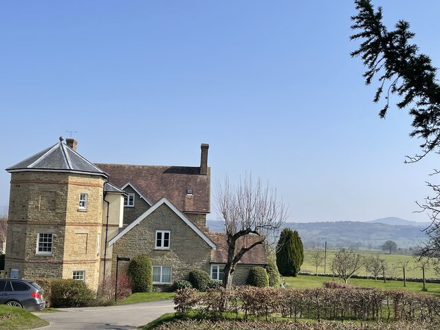
The village of Culmington itself is small and charming, with a traditional English countryside feel. Its historic buildings, including the Grade II listed Culmington Manor, give it a unique character. The parish also boasts a beautiful parish church, St. Mary Magdalene, which dates back to the 12th century and is an architectural gem.

The surrounding landscape of Culmington is predominantly rural, with rolling hills, farmlands, and numerous small woodlands. This makes it an ideal location for outdoor enthusiasts, who can enjoy activities such as walking, cycling, and horse riding in the tranquil countryside.

Culmington is well-connected to other parts of Shropshire, with good road links to nearby towns and villages. The village is also served by regular bus services, providing access to Ludlow and other nearby areas.

Despite its small size, Culmington has a strong sense of community, with various social and recreational activities taking place throughout the year. The parish is home to a number of local businesses, including a village pub, which serves as a central meeting point for residents.

In conclusion, Culmington is a charming and idyllic civil parish in Shropshire, offering a peaceful rural lifestyle and a strong community spirit.

If you have any feedback on the listing, please let us know in the comments section below.

Culmington Images

Images are sourced within 2km of 52.438633/-2.775664 or Grid Reference SO4782. Thanks to Geograph Open Source API. All images are credited.

Greenway Cross
Greenway Cross
Under Norton Camp Whettleton Woods and arable farmland.
Under Norton Camp
Whettleton Woods and arable farmland.
Almost Irish Signpost at Greenway Cross.  The National Cycle Network route is still shown after the network was severely degraded earlier in the year.
Almost Irish
Signpost at Greenway Cross. The National Cycle Network route is still shown after the network was severely degraded earlier in the year.
B4368, near Greenway Cross Craven Arms to Corve Dale road.
B4368, near Greenway Cross
Craven Arms to Corve Dale road.
Winter cereals, Whettleton Above Greenway Cross.
Winter cereals, Whettleton
Above Greenway Cross.
Road through Norton Norton is a common placename, but few of them have grown to any size.
Road through Norton
Norton is a common placename, but few of them have grown to any size.
Field of young rape seed north of Bache Believe it or not a public footpath lies through this field, unmarked by the farmer. In a month this will be inpassable unless the farmer intervenes.
Field of young rape seed north of Bache
Believe it or not a public footpath lies through this field, unmarked by the farmer. In a month this will be inpassable unless the farmer intervenes.
Bache Pool A quiet pool by Bache Farm, sounds of wildlife enjoying the peacefulness
Bache Pool
A quiet pool by Bache Farm, sounds of wildlife enjoying the peacefulness
Footpath leading around Bache Farm Doubling up as a very durable track to the farm
Footpath leading around Bache Farm
Doubling up as a very durable track to the farm
Bache Farm Magnificent farm house and attached buildings in this idyllic setting
Bache Farm
Magnificent farm house and attached buildings in this idyllic setting
Farm buildings at Norton Restored old long barn by the looks of it.
Farm buildings at Norton
Restored old long barn by the looks of it.
Grand old building in Norton Interesting extended buildings, very well manicured and now being used as apartments of some kind. Beautiful setting
Grand old building in Norton
Interesting extended buildings, very well manicured and now being used as apartments of some kind. Beautiful setting
Field of young wheat near Norton Another footpath crossing a planted field. Hopefully the farmer will delineate the footpath before the crop is fully grown.
Field of young wheat near Norton
Another footpath crossing a planted field. Hopefully the farmer will delineate the footpath before the crop is fully grown.
Entering Culmington on the B4365
Entering Culmington at The Green B4365 northbound
Entering Culmington at The Green
B4365 northbound
North bound B4365 in Culmington The lay by on the left is the village bus stop
North bound B4365 in Culmington
The lay by on the left is the village bus stop
B4365 through Seifton Looking north
B4365 through Seifton
Looking north
B4368 west near New House Just west of Pedlar's Rest Junction
B4368 west near New House
Just west of Pedlar's Rest Junction
Show me another place!

Culmington is located at Grid Ref: SO4782 (Lat: 52.438633, Lng: -2.775664)

Unitary Authority: Shropshire

Police Authority: West Mercia

What 3 Words

///scarf.advancing.cups. Near Craven Arms, Shropshire

Related Wikis

Bache, Shropshire

Bache is a hamlet in Shropshire, England. == External links == Media related to Bache, Shropshire at Wikimedia Commons

Culmington

Culmington is a village and civil parish in south Shropshire, England, about 3+1⁄2 miles (5.6 km) east of Craven Arms and 4+1⁄2 miles (7 km) north of Ludlow...

River Corve

The River Corve is a minor river in Shropshire, England. It is a tributary of the River Teme which it joins in the town of Ludlow, and which joins the...

Callow Hill, Shropshire

Callow Hill is a hill near the village of Lower Dinchope between Craven Arms and Ludlow in the English county of Shropshire. Its summit marks the highest...

Have you been to Culmington?

Leave your review of Culmington below (or comments, questions and feedback).