Covington

Civil Parish in Huntingdonshire Huntingdonshire

England

Covington

Brick Yard Cottage in the trees Of note is the narrow concrete vehicle bridge over the large ditch that provides access to the cottage.
Brick Yard Cottage in the trees Credit: Michael Trolove

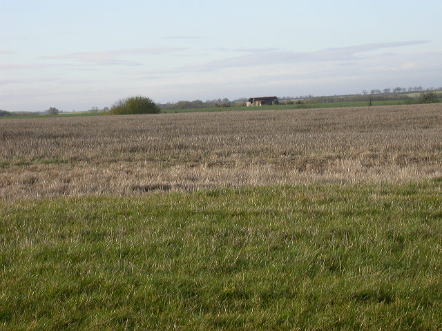
Covington is a civil parish located in the district of Huntingdonshire, Cambridgeshire, England. It is a small village situated approximately 5 miles northwest of the market town of Huntingdon. The village is set in a rural area, surrounded by picturesque countryside and farmland.

With a population of around 200 residents, Covington is a close-knit community known for its peaceful and tranquil atmosphere. The village is primarily residential, consisting of a mix of traditional cottages and more modern houses. The architecture reflects the area's history, with some buildings dating back several centuries.

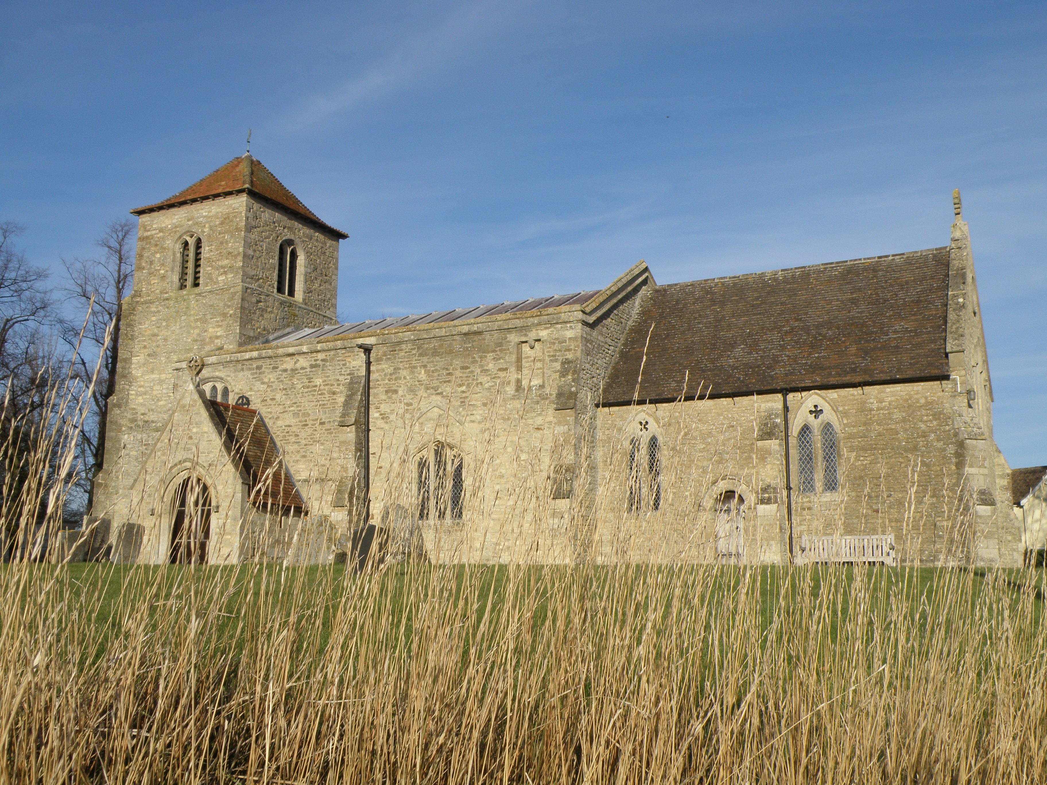
Covington is served by a small church, St. Margaret's, which is a focal point for the community. The church, with its Norman origins, adds to the village's charm and provides a place for worship and community gatherings. The village also has a community hall, where various events and activities take place throughout the year.

Although Covington is a quiet and rural village, it benefits from its proximity to larger towns and cities. Huntingdon, with its range of amenities, is just a short drive away, offering residents easy access to shops, schools, and healthcare facilities.

The surrounding countryside provides opportunities for outdoor activities, such as walking and cycling, with several footpaths and bridleways passing through the area. The River Kym flows nearby, offering fishing and boating opportunities for locals and visitors alike.

In summary, Covington is a charming and peaceful village in Huntingdonshire, offering a close-knit community, beautiful rural surroundings, and convenient access to nearby amenities.

If you have any feedback on the listing, please let us know in the comments section below.

Covington Images

Images are sourced within 2km of 52.329169/-0.448145 or Grid Reference TL0571. Thanks to Geograph Open Source API. All images are credited.

Brick Yard Cottage in the trees Of note is the narrow concrete vehicle bridge over the large ditch that provides access to the cottage.
Brick Yard Cottage in the trees
Of note is the narrow concrete vehicle bridge over the large ditch that provides access to the cottage.
Railway infrastructure remains Brick remains of a path access under the former Thrapston Huntingdon railway.
Railway infrastructure remains
Brick remains of a path access under the former Thrapston Huntingdon railway.
Catworth Lodge Viewed from the Three Shires Way.
Catworth Lodge
Viewed from the Three Shires Way.
Former railway infrastructure Brick remains of a path access under the former Thrapston Huntingdon railway.
Former railway infrastructure
Brick remains of a path access under the former Thrapston Huntingdon railway.
Former railway embankment Embankment of the former Thrapston Huntingdon railway. Closed in 1964.
Former railway embankment
Embankment of the former Thrapston Huntingdon railway. Closed in 1964.
Another end of the line An abrupt stop for the Huntingdon Thrapston railway line. Since it closed in 1964 no matter. The land has been returned to arable farming.
Another end of the line
An abrupt stop for the Huntingdon Thrapston railway line. Since it closed in 1964 no matter. The land has been returned to arable farming.
Footbridge for footpath branching off the Three Shires Way Footpath 43/8a to Catworth.
Footbridge for footpath branching off the Three Shires Way
Footpath 43/8a to Catworth.
Track to Clack Barn Bridleway on top of Mickle Hill heading towards Clack Barns. Incidentally if you have lost a pair of spectacles, these were left on the gate post.
Track to Clack Barn
Bridleway on top of Mickle Hill heading towards Clack Barns. Incidentally if you have lost a pair of spectacles, these were left on the gate post.
Leaf information boards Part of a greater environmental understanding to inform and educate, the farm along this track has information boards to explain farming activities and the interaction with the environment.<span class="nowrap"><a title="http://www.leafuk.org/leaf/home.eb" rel="nofollow ugc noopener" href="http://www.leafuk.org/leaf/home.eb">Link</a><img style="margin-left:2px;" alt="External link" title="External link - shift click to open in new window" src="https://s1.geograph.org.uk/img/external.png" width="10" height="10"/></span>
You may have seen and even used a product specific to this farm, Farringtons Mellow Yellow rape seed oil.
Leaf information boards
Part of a greater environmental understanding to inform and educate, the farm along this track has information boards to explain farming activities and the interaction with the environment.LinkExternal link You may have seen and even used a product specific to this farm, Farringtons Mellow Yellow rape seed oil.
Grass triangle road junction at Covington On the route of the Three Shires Way.
Grass triangle road junction at Covington
On the route of the Three Shires Way.
All Saints' church Covington The church was also dedicated to St. Margaret at some point. The nave is C11. The first recorded priest was Richard De Baiocis who retired in 1293 (see <span class="nowrap"><a title="http://www.covington.org.uk/gallery/trailmappage.pdf" rel="nofollow ugc noopener" href="http://www.covington.org.uk/gallery/trailmappage.pdf">Link</a><img style="margin-left:2px;" alt="External link" title="External link - shift click to open in new window" src="https://s1.geograph.org.uk/img/external.png" width="10" height="10"/></span> )
All Saints' church Covington
The church was also dedicated to St. Margaret at some point. The nave is C11. The first recorded priest was Richard De Baiocis who retired in 1293 (see LinkExternal link )
All Saints' church Covington and manor house The nave of the church dates from the C11. the manor house dates from 1731 but was built on the site of an ancient moated building.
All Saints' church Covington and manor house
The nave of the church dates from the C11. the manor house dates from 1731 but was built on the site of an ancient moated building.
Ordnance Survey Cut Mark This OS cut mark can be found on the NE face of St Margaret's Church. It marks a point 13.610m above mean sea level.
Ordnance Survey Cut Mark
This OS cut mark can be found on the NE face of St Margaret's Church. It marks a point 13.610m above mean sea level.
Three Shires Way Village of Hargrave in the distance.
Three Shires Way
Village of Hargrave in the distance.
Covington church
Covington church
Water Tower From a bridleway leading south-east out of Hargrave.
Water Tower
From a bridleway leading south-east out of Hargrave.
Lost Railway Site of the old Kettering to Huntingdon railway, now rather overgrown as it is not used as a footpath, at least on this stretch.
Lost Railway
Site of the old Kettering to Huntingdon railway, now rather overgrown as it is not used as a footpath, at least on this stretch.
Field of stubble and farm building A view to the west.
Field of stubble and farm building
A view to the west.
Show me another place!

Covington is located at Grid Ref: TL0571 (Lat: 52.329169, Lng: -0.448145)

Administrative County: Cambridgeshire

District: Huntingdonshire

Police Authority: Cambridgeshire

What 3 Words

///processes.teach.speedily. Near Swineshead, Bedfordshire

Nearby Locations

Covington

Related Wikis

Covington, Cambridgeshire

Covington is a village and civil parish in Cambridgeshire, England. Covington lies approximately 10 miles (16 km) west of Huntingdon near to Catworth and...

Hargrave, Northamptonshire

Hargrave is a small village and civil parish situated in rural Northamptonshire, England, approximately 21 miles east of Northampton and adjacent to the...

Lower Dean

Lower Dean is a village located in the Borough of Bedford in Bedfordshire, England. The village forms part of the Dean and Shelton civil parish (where...

Tilbrook

Tilbrook is a village and civil parish in Cambridgeshire, England. Tilbrook lies approximately 10 miles (16 km) west of Huntingdon, near Covington. Tilbrook...

Nearby Amenities

Located within 500m of 52.329169,-0.448145
Telephone
Defibrillator
Booth: K6
Covered: booth
Defibrillator Location: inside red phone box, Keystone Road, Covington
Emergency: defibrillator
Listed Status: Grade II
Man Made: telephone_box
Lat/Long: 52.3251721/-0.4512976
The data included in this document is from www.openstreetmap.org. The data is made available under ODbL.

Have you been to Covington?

Leave your review of Covington below (or comments, questions and feedback).