Alderton

Settlement in Gloucestershire Tewkesbury

England

Alderton

St Mary's Church, Little Washbourne
St Mary's Church, Little Washbourne Credit: AJD

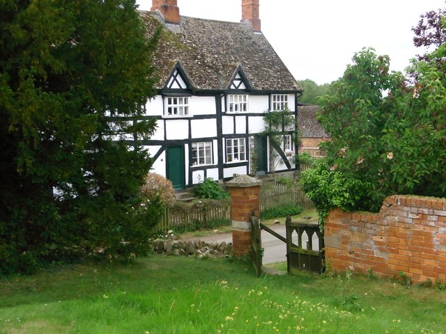
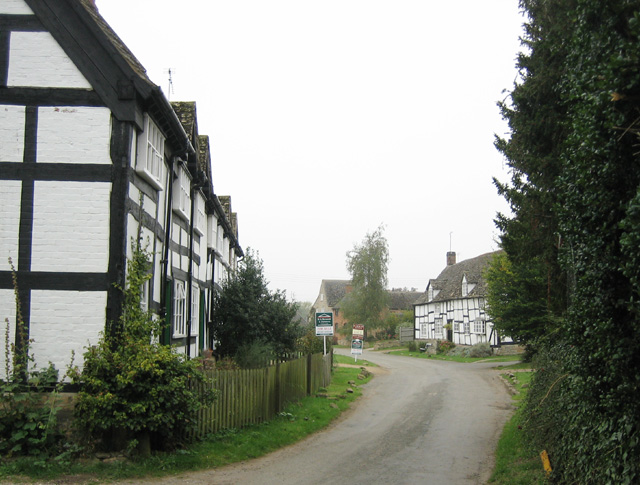
Alderton is a picturesque village located in the county of Gloucestershire, England. Nestled in the heart of the Cotswolds, this charming settlement is situated about 10 miles northwest of the historic town of Cheltenham. With a population of around 1,000 residents, Alderton offers a tranquil and close-knit community atmosphere.

The village is renowned for its quintessentially English architecture, featuring a mix of stone cottages, thatched roofs, and well-maintained gardens. The surrounding countryside is idyllic, with rolling hills and lush green fields, providing a stunning backdrop to this rural haven.

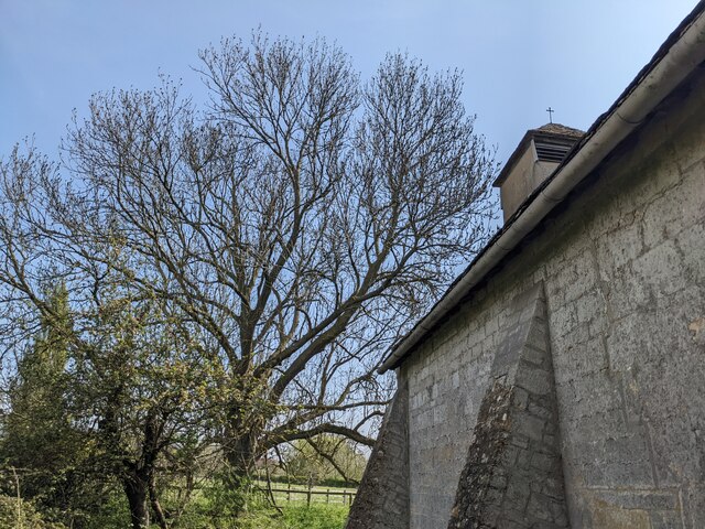
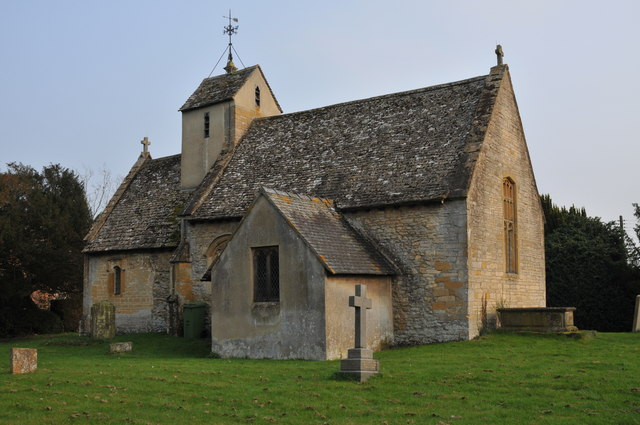
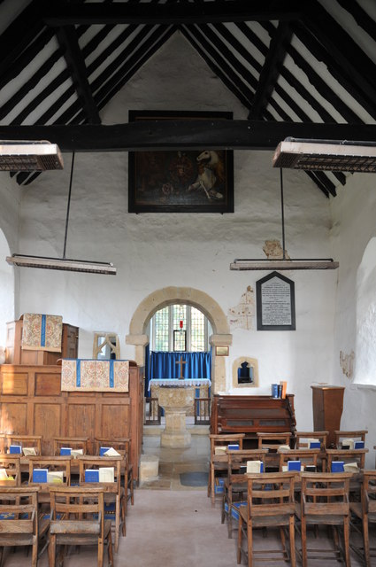
Alderton boasts a rich history, dating back to Saxon times. The village is home to the Grade I listed St. Margaret's Church, a beautiful medieval structure that showcases intricate stonework and stained glass windows. The church is a focal point for religious and community events throughout the year.

In terms of amenities, Alderton offers a range of facilities to cater to its residents' needs. These include a post office, a village shop, a well-regarded primary school, and a friendly local pub, where visitors can enjoy a traditional pub meal or a pint of locally brewed ale.

For outdoor enthusiasts, the village is surrounded by stunning countryside, making it an ideal location for walking, hiking, and cycling. The nearby Cotswold Way and Winchcombe Way offer numerous trails to explore, providing breathtaking views of the surrounding landscape.

In summary, Alderton, Gloucestershire, is a picturesque village steeped in history, offering a tranquil and close-knit community, stunning countryside, and a range of amenities to cater to its residents' needs.

If you have any feedback on the listing, please let us know in the comments section below.

Alderton Images

Images are sourced within 2km of 51.998207/-1.999211 or Grid Reference SP0033. Thanks to Geograph Open Source API. All images are credited.

St Mary's Church, Little Washbourne
Pipeline crossing a brook Pipeline crossing a brook in the village of Alderton.  This subject was the first picture submitted on this webpage for this grid square, see: <a href="https://www.geograph.org.uk/photo/67965">SO9932 : Pipeline near Alderton</a>.
Pipeline crossing a brook
Pipeline crossing a brook in the village of Alderton. This subject was the first picture submitted on this webpage for this grid square, see: SO9932 : Pipeline near Alderton.
Alder Green development Alder Green development site in the village of Alderton.
Alder Green development
Alder Green development site in the village of Alderton.
Winchcombe Way leading north towards Washbourne Hill from Alderton
Trees at St. Mary church (Little Washbourne) The church of St. Mary in Little Washbourne is surrounded by several trees, and this view faces east to the north of the church structure.
Trees at St. Mary church (Little Washbourne)
The church of St. Mary in Little Washbourne is surrounded by several trees, and this view faces east to the north of the church structure.
St. Mary's church (Little Washbourne) The small church of St. Mary is sheltered in a churchyard with trees east of the B4077 road. Founded and built in the twelfth century, this was altered in the eighteenth century, and the building has seen little change since. This was grade II* listed in July 1960, and is in the care of the Churches Conservation Trust.
St. Mary's church (Little Washbourne)
The small church of St. Mary is sheltered in a churchyard with trees east of the B4077 road. Founded and built in the twelfth century, this was altered in the eighteenth century, and the building has seen little change since. This was grade II* listed in July 1960, and is in the care of the Churches Conservation Trust.
St. Mary's church (Little Washbourne) The small church of St. Mary is sheltered in a churchyard with trees east of the B4077 road. Founded and built in the twelfth century, it was altered in the eighteenth century, and the building has seen little change since. It was grade II* listed in July 1960, and is in the care of the Churches Conservation Trust. This was the last place we visited in the Cotswolds on this day, and I felt relieved that this site was peaceful compared to our visits in Broadway and Toddington church (the latter because I think a local keeps an eye on tourists looking at Toddington Manor, covered in scaffolding since 2005). There were daffodils in the churchyard on my visit to Little Washbourne, although they look deceased.
St. Mary's church (Little Washbourne)
The small church of St. Mary is sheltered in a churchyard with trees east of the B4077 road. Founded and built in the twelfth century, it was altered in the eighteenth century, and the building has seen little change since. It was grade II* listed in July 1960, and is in the care of the Churches Conservation Trust. This was the last place we visited in the Cotswolds on this day, and I felt relieved that this site was peaceful compared to our visits in Broadway and Toddington church (the latter because I think a local keeps an eye on tourists looking at Toddington Manor, covered in scaffolding since 2005). There were daffodils in the churchyard on my visit to Little Washbourne, although they look deceased.
Pipeline at Alderton Renewal work appears to have taken place on this pipeline since I photographed it last September <a href="https://www.geograph.org.uk/photo/7292820">SO9932 : Pipeline crossing a brook</a>.
Pipeline at Alderton
Renewal work appears to have taken place on this pipeline since I photographed it last September SO9932 : Pipeline crossing a brook.
House building at Alderton Ubiquitous house building such as this here on the approach to the village of Alderton could be anywhere.
House building at Alderton
Ubiquitous house building such as this here on the approach to the village of Alderton could be anywhere.
House building at Alderton New housing development on the southern edge of the village in Alderton.
House building at Alderton
New housing development on the southern edge of the village in Alderton.
Great Washbourne church Great Washbourne church viewed from the north-west.
Great Washbourne church
Great Washbourne church viewed from the north-west.
Interior, Great Washbourne church The interior of St Mary's church at Great Washbourne
Interior, Great Washbourne church
The interior of St Mary's church at Great Washbourne
Remains of frescos, Great Washbourne church Remains of wall frescos in St Mary's church Great Washbourne.
Remains of frescos, Great Washbourne church
Remains of wall frescos in St Mary's church Great Washbourne.
Remains of frescos, Great Washbourne church Remains of wall frescos in St Mary's church Great Washbourne.
Remains of frescos, Great Washbourne church
Remains of wall frescos in St Mary's church Great Washbourne.
War Memorial, Great Washbourne church The names of three who fell in the Great War: A V Dyer, R Myatt, and A Shakespeare, on a war memorial on the wall of St Mary's church, Great Washbourne.
War Memorial, Great Washbourne church
The names of three who fell in the Great War: A V Dyer, R Myatt, and A Shakespeare, on a war memorial on the wall of St Mary's church, Great Washbourne.
Houses opposite Great Washbourne church
Scrub and fields next to B4077 close to Willowbrook Farm, Alderton
Car park at Hobnails Inn
Show me another place!

Alderton is located at Grid Ref: SP0033 (Lat: 51.998207, Lng: -1.999211)

Administrative County: Gloucestershire

District: Tewkesbury

Police Authority: Gloucestershire

What 3 Words

///limbs.officials.advances. Near Winchcombe, Gloucestershire

Nearby Locations

Alderton

Related Wikis

Alderton, Gloucestershire

Alderton is a village and civil parish in the Tewkesbury district of Gloucestershire, England. The village is about 15 miles (24 km) north of Cheltenham...

Little Washbourne

Little Washbourne is a village and former civil parish, now in the parish of Dumbleton, in the Tewkesbury district, in Gloucestershire, England, 6 miles...

St Mary's Church, Little Washbourne

St Mary's Church, is a historic Anglican church at Little Washbourne in the civil parish of Dumbleton, Gloucestershire, England under the care of the Churches...

Alderton Hill Quarry

Alderton Hill Quarry (grid reference SP006345) is a 0.34-hectare (0.84-acre) geological Site of Special Scientific Interest in Gloucestershire, notified...

Great Washbourne

Great Washbourne is a village and former civil parish, now in the parish of Dumbleton, in the Tewkesbury district, in Gloucestershire, England, 6 miles...

Alstone, Tewkesbury

Alstone is a village and former civil parish, now in the parish of Teddington, in the Tewkesbury district, in the county of Gloucestershire, England, situated...

Dumbleton Hall

Dumbleton Hall is in the village of Dumbleton between the towns of Evesham and Tewkesbury and on the boundary of Worcestershire and Gloucestershire. The...

Gretton Halt railway station

Gretton Halt railway station was a halt opened by the Great Western Railway on the Honeybourne Line from Honeybourne to Cheltenham which served the small...

Nearby Amenities

Located within 500m of 51.998207,-1.999211
Alderton
Place: village
Lat/Long: 51.9977115/-2.0000386
Pub
The Gardeners Arms
Addr Postcode: GL20 8NL
Addr Street: Beckford Road
Fhrs Id: 3663
Url: http://www.gardenersarms.biz/
Wikidata: Q26384035
Lat/Long: 51.9987016/-2.0023658
Cambridge Square
Naptan AtcoCode: 1600GL59
Naptan Bearing: N
Naptan BusStopType: CUS
Naptan CommonName: Cambridge Square
Naptan NaptanCode: glodwmdw
Naptan Street: Cambridge Square
Naptan Verified: no
Source: naptan_import
Lat/Long: 51.9981587/-1.9993445
Bus Stop
Cambridge Square
Bus: yes
Naptan AtcoCode: 1600GL60
Naptan Bearing: SE
Naptan CommonName: Cambridge Square
Naptan NaptanCode: glodwmgd
Naptan Street: Cambridge Square
Naptan Verified: no
Public Transport: platform
Source: naptan_import
Lat/Long: 51.9982216/-1.9991697
Brookside
Naptan AtcoCode: 1600GL63
Naptan Bearing: SE
Naptan BusStopType: CUS
Naptan CommonName: Brookside
Naptan NaptanCode: glodwmpg
Naptan Street: Dibden Lane
Naptan Verified: no
Source: naptan_import
Lat/Long: 51.9981304/-1.9955755
Noexit: yes
Lat/Long: 51.9965467/-1.9978732
Barrier: stile
Foot: yes
Material: wood
Source: survey
Stile: stepover
Lat/Long: 51.9964993/-1.9979342
Barrier: kissing_gate
Lat/Long: 51.9989585/-1.9990332
Barrier: stile
Foot: yes
Source: survey
Lat/Long: 51.9997318/-1.9984471
Post Office
Alderton Village Store
Addr Country: GB
Addr Housenumber: 10
Addr Postcode: GL20 8NW
Addr Street: Blacksmiths Road
Fhrs Id: 3773
Opening Hours Post Office: Mo-Fr 09:00-13:00; Sa 09:00-12:30
Ref Pol Id: 2890
Shop: convenience
Source Addr: FSA Food Hygiene Ratings Database
Lat/Long: 51.9974633/-1.9994308
Post Box
Collection Times: Mo-Fr 16:30; Sa 09:10
Post Box Type: wall
Ref: GL20 40
Royal Cypher: GVIR
Royal Cypher Wikidata: Q33102169
Lat/Long: 51.997395/-1.9993846
Bench
Lat/Long: 51.9981958/-1.9993389
Turning Circle
Lat/Long: 51.9951606/-1.9986204
Saint Margarets Drive
Location Transition: yes
Material: wood
Power: pole
Transformer: distribution
Voltage Primary: 11000
Lat/Long: 51.9951327/-2.0007113
Material: wood
Power: pole
Source: bing
Lat/Long: 51.9945195/-2.0007831
Historic: memorial
Memorial: war_memorial
Lat/Long: 51.9969588/-2.0024058
Access: private
Service: driveway
Lat/Long: 51.9970652/-1.9964597
Defibrillator
Booth: K6
Covered: booth
Defibrillator Location: Inside old red telephone box, Cambridge Square, Aldetron
Disused Amenity: telephone
Emergency: defibrillator
Man Made: telephone_box
Ref: CHT-10-129
Lat/Long: 51.9982133/-1.9993355
Generator Method: photovoltaic
Generator Output Electricity: yes
Generator Source: solar
Generator Type: solar_photovoltaic_panel
Location: roof
Power: generator
Lat/Long: 51.9987175/-1.9980767
Alderton
Material: wood
Power: pole
Transformer: distribution
Voltage Primary: 11000
Lat/Long: 51.9965558/-1.9991684
Material: wood
Power: pole
Lat/Long: 51.9961995/-1.9997947
Material: wood
Power: pole
Lat/Long: 51.9958651/-2.0004525
Waste Basket
Waste: dog_excrement
Lat/Long: 51.9978151/-1.9948138
Entrance: main
Lat/Long: 51.9980318/-1.9973157
Information: board
Tourism: information
Lat/Long: 51.998077/-1.9974136
Waste Basket
Lat/Long: 51.998071/-1.9974223
Bench
Lat/Long: 51.9980595/-1.9974223
Waste Basket
Lat/Long: 51.9981874/-1.9972922
Waste Basket
Waste: dog_excrement
Lat/Long: 51.9982015/-1.9972774
Material: wood
Power: pole
Lat/Long: 51.9954072/-2.004274
Willow Bank Road
Location Transition: yes
Material: wood
Power: pole
Transformer: distribution
Voltage Primary: 11000
Lat/Long: 51.9960307/-2.0038435
Dibden Lane
Power: pole
Transformer: distribution
Voltage Primary: 11000
Lat/Long: 51.9984847/-1.9951424
Power: pole
Lat/Long: 51.9990173/-1.996173
Location Transition: yes
Power: pole
Transformer: distribution
Voltage Primary: 11000
Lat/Long: 51.9990949/-1.9975014
Power: transformer
Transformer: distribution
Voltage Primary: 11000
Lat/Long: 51.9984752/-2.0019753
Material: wood
Power: pole
Lat/Long: 51.9977127/-2.0033654
Material: wood
Power: pole
Lat/Long: 51.9983501/-2.0027874
Material: wood
Power: pole
Lat/Long: 51.9970207/-2.0040064
Material: wood
Power: pole
Lat/Long: 51.9965938/-2.0044027
Power: pole
Lat/Long: 51.9977044/-2.0051229
Location Transition: yes
Power: pole
Lat/Long: 51.9977985/-2.0052516
Information: board
Tourism: information
Lat/Long: 51.9969922/-2.0022469
Bench
Source: survey;gps
Lat/Long: 51.9969951/-2.0023026
The data included in this document is from www.openstreetmap.org. The data is made available under ODbL.

Have you been to Alderton?

Leave your review of Alderton below (or comments, questions and feedback).