Abdon

Settlement in Shropshire

England

Abdon

Grassland beneath the Brown Clee Pasture at Lower Earnstrey.
Grassland beneath the Brown Clee Credit: Richard Webb

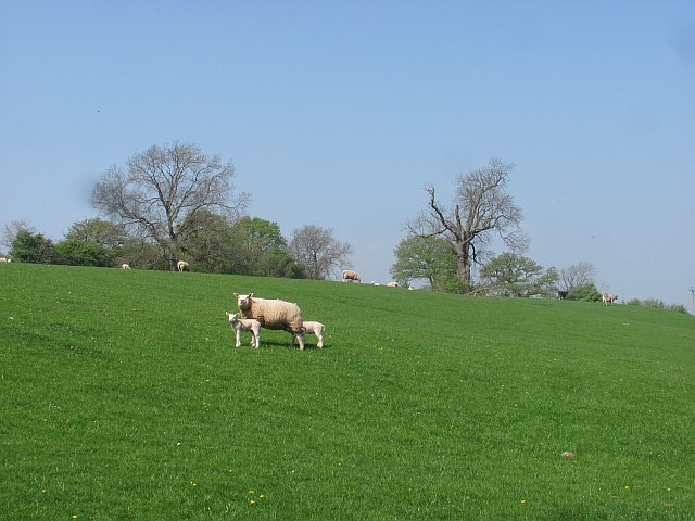
Abdon is a small village located in the county of Shropshire, England. Situated in the heart of the beautiful Shropshire Hills, it is surrounded by picturesque countryside and offers stunning views of the rolling hills and valleys that characterize the area.

The village itself is home to a tight-knit community, with a population of around 200 residents. It boasts a charming and peaceful atmosphere, making it an ideal place for those seeking a quiet and idyllic rural setting. The architecture in Abdon reflects its historical roots, with many traditional cottages and farmhouses still standing.

Despite its small size, Abdon is not lacking in amenities. The village has a local pub, serving as a hub for social gatherings and a place to enjoy a pint or a hearty meal. Additionally, there is a village hall that hosts various community events and activities throughout the year.

For outdoor enthusiasts, Abdon offers ample opportunities for exploring the surrounding countryside. The nearby Shropshire Hills provide a range of walking and hiking trails, allowing residents and visitors to fully immerse themselves in the natural beauty of the area. The village is also within close proximity to other attractions in Shropshire, such as the historic town of Ludlow and the Ironbridge Gorge.

Overall, Abdon is a quaint and peaceful village that offers a tranquil escape from the hustle and bustle of city life. With its stunning natural surroundings and strong sense of community, it is a place that appeals to those seeking a slower pace of life and a connection to nature.

If you have any feedback on the listing, please let us know in the comments section below.

Abdon Images

Images are sourced within 2km of 52.473401/-2.6284813 or Grid Reference SO5786. Thanks to Geograph Open Source API. All images are credited.

Grassland beneath the Brown Clee Pasture at Lower Earnstrey.
Grassland beneath the Brown Clee
Pasture at Lower Earnstrey.
Ash pile Remains of some hedging work. There is a small area of hazel wood here around a brook. The soil is red from the sandstones which underlie the dolerite caps and coal measures of the Clee Hills.
Ash pile
Remains of some hedging work. There is a small area of hazel wood here around a brook. The soil is red from the sandstones which underlie the dolerite caps and coal measures of the Clee Hills.
Lambs under the Brown Clee Grassland near Abdon.
Lambs under the Brown Clee
Grassland near Abdon.
Grown out hedge, Abdon
Site of Abdon Beside the church, this the site of the medieval village. Today Abdon is a scattering of farms without any centre, but once there was a nuclear village here.
Lost villages are a feature of the uplands around the Clee Hills and Bromyard uplands. Nearby are other examples like Bitterley and Holdgate.
Site of Abdon
Beside the church, this the site of the medieval village. Today Abdon is a scattering of farms without any centre, but once there was a nuclear village here. Lost villages are a feature of the uplands around the Clee Hills and Bromyard uplands. Nearby are other examples like Bitterley and Holdgate.
Minor road, Abdon Car parking space outside the church.
Minor road, Abdon
Car parking space outside the church.
Ewe and lambs Grazing for sheep, the usual land use here with a long history.
Ewe and lambs
Grazing for sheep, the usual land use here with a long history.
Clee St Margaret to Abdon road Narrow lane between high hedges.
Clee St Margaret to Abdon road
Narrow lane between high hedges.
Clee St Margaret to Abdon road A narrow lane under Brown Clee Hill.
Clee St Margaret to Abdon road
A narrow lane under Brown Clee Hill.
Primitive Methodist Chapel Built in 1869.
Primitive Methodist Chapel
Built in 1869.
View up to Nordy Bank from the lower slopes of Clee Liberty Common Clee Liberty describes the feeling you get from being here.

Nordy Bank is one of the area's many Iron Age hillforts.
View up to Nordy Bank from the lower slopes of Clee Liberty Common
Clee Liberty describes the feeling you get from being here. Nordy Bank is one of the area's many Iron Age hillforts.
Dog walker on Clee Liberty below Nordy Bank This lady is lucky enough to live up here and daily has the privilege of walking her Rottie on these slopes, despite his recent leg op. She pointed out some of the views and gave me tips on what to look for from Nordy Bank. I always appreciate local expert knowledge, especially when freely given.
Dog walker on Clee Liberty below Nordy Bank
This lady is lucky enough to live up here and daily has the privilege of walking her Rottie on these slopes, despite his recent leg op. She pointed out some of the views and gave me tips on what to look for from Nordy Bank. I always appreciate local expert knowledge, especially when freely given.
View down the slopes of Nordy Bank What a spot. Shropshire at its best.
View down the slopes of Nordy Bank
What a spot. Shropshire at its best.
Part of Nordy Bank hillfort With a distant view to Titterstone Clee Hill.
Part of Nordy Bank hillfort
With a distant view to Titterstone Clee Hill.
On Nordy Bank looking to Brown Clee Sheep graze the interior of the hillfort, which commands great all round views.
On Nordy Bank looking to Brown Clee
Sheep graze the interior of the hillfort, which commands great all round views.
On Nordy Bank The westering sun creates nice effects over the ramparts and the lands beyond.
On Nordy Bank
The westering sun creates nice effects over the ramparts and the lands beyond.
Ramparts on Nordy Bank hillfort Not a multivallate fort but still an impressive site.
Ramparts on Nordy Bank hillfort
Not a multivallate fort but still an impressive site.
Brown Clee Hill The trig point was still here in 2002 and summit is 150 metres north of trig.
Shropshire (1974) administrative county top, Shropshire historic county top and Shropshire current county/UA top.
Name: Brown Clee Hill
Hill number: 2837
Height: 540m / 1772ft
Area: 38A: Shropshire
Class: Ma,5,CoH,CoU, CoA
Grid ref: SO 59375 86705
Summit feature: heathery mound near masts
Drop: 373m
Col: 167m  SO610955
Brown Clee Hill
The trig point was still here in 2002 and summit is 150 metres north of trig. Shropshire (1974) administrative county top, Shropshire historic county top and Shropshire current county/UA top. Name: Brown Clee Hill Hill number: 2837 Height: 540m / 1772ft Area: 38A: Shropshire Class: Ma,5,CoH,CoU, CoA Grid ref: SO 59375 86705 Summit feature: heathery mound near masts Drop: 373m Col: 167m SO610955
Show me another place!

Abdon is located at Grid Ref: SO5786 (Lat: 52.473401, Lng: -2.6284813)

Unitary Authority: Shropshire

Police Authority: West Mercia

What 3 Words

///swept.depths.aimless. Near Cardington, Shropshire

Nearby Locations

Abdon

Related Wikis

Abdon, Shropshire

Abdon is an upland village and former civil parish, now in the parish of Abdon and Heath, in Shropshire, England. In 2011 the parish had a population of...

Heath, Shropshire

Heath is a hamlet and former civil parish, now in the parish of Abdon and Heath, in the Clee Hills area of Shropshire, England. The settlement and wider...

Nordy Bank

Nordy Bank is an Iron Age hill fort on Brown Clee Hill in the Shropshire Hills Area of Outstanding Natural Beauty in South Shropshire, England. == Location... ==
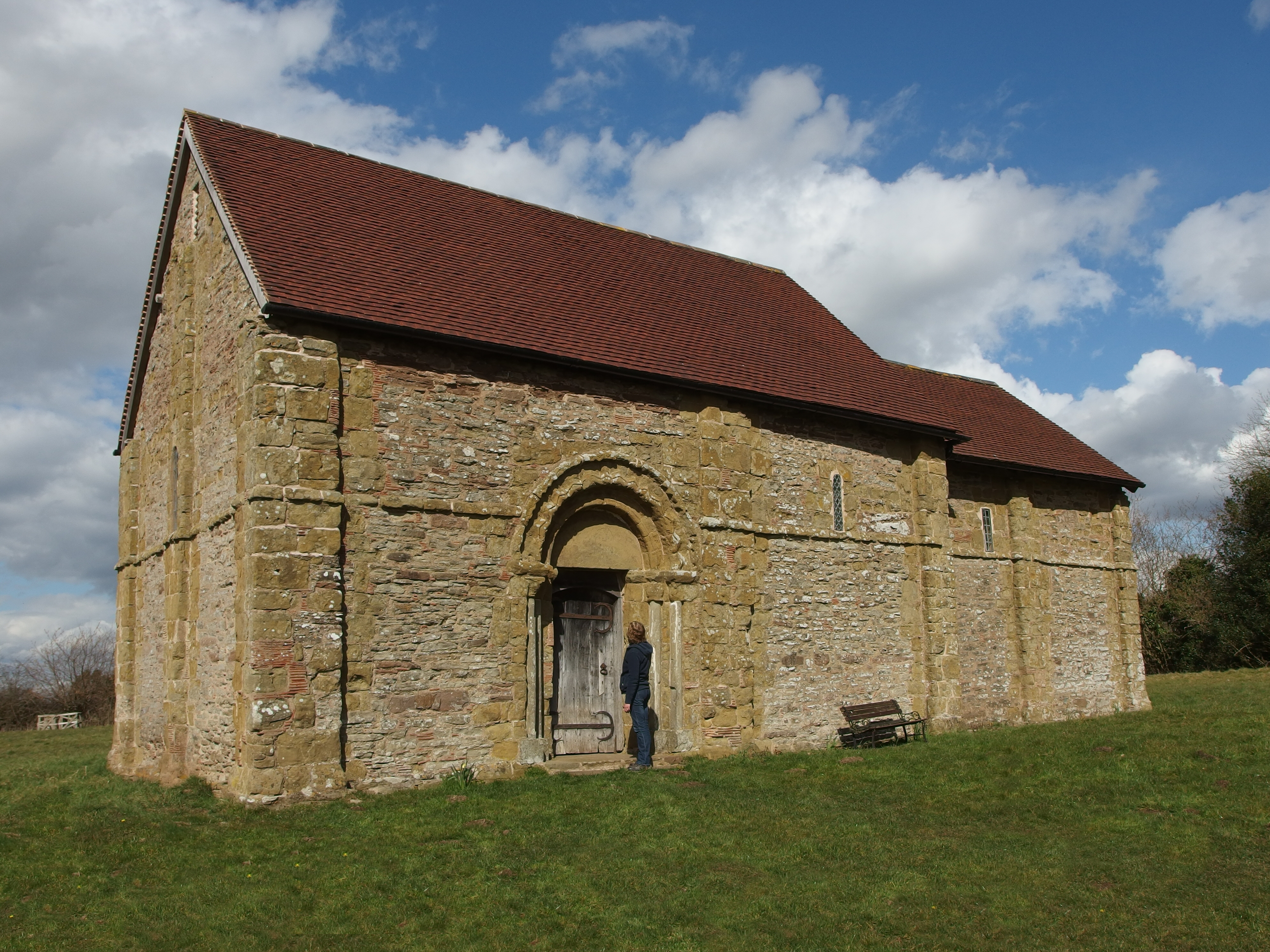
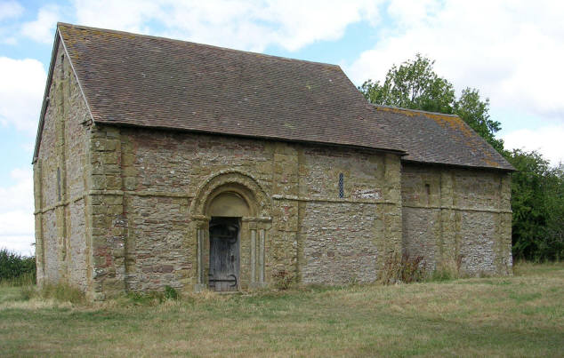
Heath Chapel

Heath Chapel is located in an isolated position in a field in the former civil parish of Heath, Shropshire, England. It is an Anglican chapel in the deanery...

Tugford

Tugford is a village and former civil parish, now in the parish of Abdon and Heath, in the Shropshire district, in the ceremonial county of Shropshire...

Brown Clee Hill

Brown Clee Hill is the highest hill in the rural English county of Shropshire, at 540 metres (1,770 ft) above sea level. It is one of the Clee Hills,...

Clee St. Margaret

Clee St. Margaret is a small village and civil parish in the Clee Hills area of Shropshire, England. It is seven miles north east (about a fifteen-minute...

Bouldon

Bouldon is a hamlet in Shropshire, England. It lies in the civil parish of Diddlebury. The hamlet comprises approximately 14 houses, a number of agricultural...

Nearby Amenities

Located within 500m of 52.473401,-2.6284813
Abdon
Place: village
Wikidata: Q4665129
Lat/Long: 52.4742358/-2.6261191
Post Box
Post Box Type: wall
Ref: SY7 104
Royal Cypher: VR
Royal Cypher Wikidata: Q33102356
Lat/Long: 52.4731666/-2.6244233
Building: yes
Lat/Long: 52.4741967/-2.6242225
Generator Method: photovoltaic
Generator Output Electricity: yes
Generator Source: solar
Generator Type: solar_photovoltaic_panel
Location: roof
Power: generator
Lat/Long: 52.4736596/-2.62658
The data included in this document is from www.openstreetmap.org. The data is made available under ODbL.

Have you been to Abdon?

Leave your review of Abdon below (or comments, questions and feedback).