Buslingthorpe

Civil Parish in Lincolnshire West Lindsey

England

Buslingthorpe

Farm building near Lissington
Farm building near Lissington Credit: David Brown

Buslingthorpe is a small civil parish located in the East Lindsey district of Lincolnshire, England. It is situated approximately 4 miles southwest of the market town of Horncastle. The parish covers an area of about 4.5 square miles and is surrounded by picturesque countryside.

The village of Buslingthorpe itself is a quiet and rural settlement with a population of around 150 residents. It is characterized by its charming traditional cottages and agricultural buildings, many of which date back several centuries. The parish is predominantly agricultural, with farming being the main occupation of its inhabitants.

Despite its small size, Buslingthorpe has a strong sense of community. The village has a local pub, the Buslingthorpe Arms, which is a popular meeting place for residents and visitors alike. The parish also has a village hall, which serves as a venue for various social events and gatherings.

The surrounding countryside offers opportunities for outdoor activities such as walking, cycling, and horse riding. The parish is blessed with beautiful landscapes, including rolling hills, open fields, and woodlands. It is a tranquil and idyllic setting, perfect for those seeking a peaceful retreat from the hustle and bustle of city life.

In summary, Buslingthorpe is a charming and close-knit rural parish in Lincolnshire, known for its picturesque countryside, traditional architecture, and strong community spirit.

If you have any feedback on the listing, please let us know in the comments section below.

Buslingthorpe Images

Images are sourced within 2km of 53.3537/-0.370758 or Grid Reference TF0885. Thanks to Geograph Open Source API. All images are credited.

Farm building near Lissington
Interior, St Michael's church, Buslingthorpe The tiny, grade II* listed St.Michael's church was rebuilt by E.J.Wilson in 1835 on the site of the medieval church, retaining the low medieval tower and 13th century chancel arch. It has a rare treasure in one of the earliest military brasses in England, to Sir Richard de Buslingthorpe c1300.
The village of Buslingthorpe has shrunk to just a few houses around Manor Farm and St.Michael's church, with extensive earthworks marking the site of the village and open field system as a Scheduled Ancient Monument
 It was grade II* listed in November 1966 and declared redundant in 1984
Interior, St Michael's church, Buslingthorpe
The tiny, grade II* listed St.Michael's church was rebuilt by E.J.Wilson in 1835 on the site of the medieval church, retaining the low medieval tower and 13th century chancel arch. It has a rare treasure in one of the earliest military brasses in England, to Sir Richard de Buslingthorpe c1300. The village of Buslingthorpe has shrunk to just a few houses around Manor Farm and St.Michael's church, with extensive earthworks marking the site of the village and open field system as a Scheduled Ancient Monument It was grade II* listed in November 1966 and declared redundant in 1984
St Michael's church, Buslingthorpe Declared redundant in 1984.
St Michael's church, Buslingthorpe
Declared redundant in 1984.
Medieval stained glass, St Michael's church, Buslingthorpe The shield of Deyville from the 14th C.
Probably to Robert Deyville, Rector of Buslingthorpe 1349-1369.

The upper part shows Oak foliage circa 1310-50. The yellow border is similar to one at Wickenby. <a href="https://www.geograph.org.uk/photo/3975234">TF0881 : Medieval Stained Glass Fragments, Wickenby church</a>
Medieval stained glass, St Michael's church, Buslingthorpe
The shield of Deyville from the 14th C. Probably to Robert Deyville, Rector of Buslingthorpe 1349-1369. The upper part shows Oak foliage circa 1310-50. The yellow border is similar to one at Wickenby. TF0881 : Medieval Stained Glass Fragments, Wickenby church
Save the pigs! The arks have been moved to higher ground Mill Lane, Middle Rasen. Leads to Gibbet Lane.
Save the pigs! The arks have been moved to higher ground
Mill Lane, Middle Rasen. Leads to Gibbet Lane.
Is it a BOAT or do you just need one? Byway off Mill Lane South of Middle Rasen. Leads to Gibbet Lane.
Is it a BOAT or do you just need one? Byway off Mill Lane
South of Middle Rasen. Leads to Gibbet Lane.
Is it a BOAT or do you just need one? Byway off Mill Lane South of Middle Rasen.
Is it a BOAT or do you just need one? Byway off Mill Lane
South of Middle Rasen.
Rutted Byway from Mill Lane to Gibbet Lane (A46)
Unnamed drain crossing Mill Lane, Middle Rasen
Buslingthorpe Bridge from Buslingthorpe level crossing
North of the lane to Buslingthorpe Remains of dead tree at far end.
North of the lane to Buslingthorpe
Remains of dead tree at far end.
Molehills by the lane to Lissingley Level Crossing
Paddock by Musgrave Farm
Across an unnamed drain near Buslingthorpe Wood
Diking by the footpath past Buslingthorpe Wood
View towards Lissingley Farm
Spring in Lissingley Lane After a raw start, finally a spring day, and people are out in their droves in the countryside, of foot and every form of transport.
Spring in Lissingley Lane
After a raw start, finally a spring day, and people are out in their droves in the countryside, of foot and every form of transport.
Sunday afternoon sport on the byway off Gibbet Lane After a raw start, finally a spring day, and people are out in their droves in the countryside, of foot and every form of transport.
Sunday afternoon sport on the byway off Gibbet Lane
After a raw start, finally a spring day, and people are out in their droves in the countryside, of foot and every form of transport.
Show me another place!

Buslingthorpe is located at Grid Ref: TF0885 (Lat: 53.3537, Lng: -0.370758)

Administrative County: Lincolnshire

District: West Lindsey

Police Authority: Lincolnshire

What 3 Words

///alerting.homing.blackouts. Near Middle Rasen, Lincolnshire

Related Wikis

Buslingthorpe, Lincolnshire

Buslingthorpe is a hamlet and civil parish in the West Lindsey district of Lincolnshire, England. It is half a mile east of the A46 at Faldingworth and...

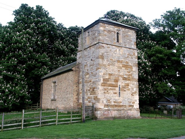
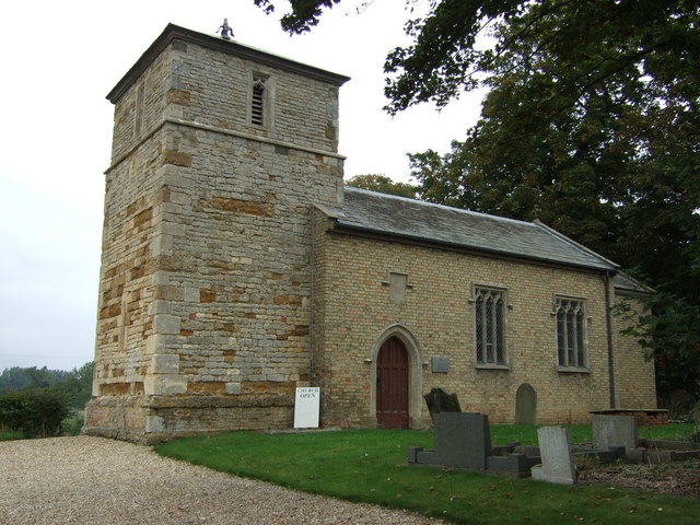
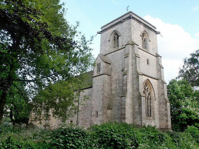
St Michael's Church, Buslingthorpe

St Michael's Church is a redundant Anglican church in the hamlet of Buslingthorpe, Lincolnshire, England. It is recorded in the National Heritage List...

Faldingworth

Faldingworth is a village and civil parish in the West Lindsey district of Lincolnshire, England. It is situated on the A46, and approximately 5 miles...

Friesthorpe

Friesthorpe is a settlement and civil parish in the West Lindsey district of Lincolnshire, England. The population of the civil parish (including Snarford...

Wickenby railway station

Wickenby railway station was a station in Wickenby, Lincolnshire on the line between Lincoln and Grimsby, opened in 1848 and closed in 1965. == References... ==

Linwood, Lincolnshire

Linwood is a small village and civil parish in the West Lindsey district of Lincolnshire, England, on the minor B1202 road about 2 miles (3 km) south from...

Lissington

Lissington is a village and civil parish in the West Lindsey district of Lincolnshire, England. The population of the civil parish at the 2011 census was...

Wickenby

Wickenby is a hamlet and civil parish in the West Lindsey district of Lincolnshire, England. It is situated approximately 5 miles (8.0 km) south-west from...

Nearby Amenities

Located within 500m of 53.3537,-0.370758
Manor Farm
Place: farm
Source: Bing
Lat/Long: 53.3525588/-0.3772839
The data included in this document is from www.openstreetmap.org. The data is made available under ODbL.

Have you been to Buslingthorpe?

Leave your review of Buslingthorpe below (or comments, questions and feedback).