Bramley

Civil Parish in Hampshire Basingstoke and Deane

England

Bramley

Another Grey Gate These industrial looking metal barriers are obviously the gate of choice for the Stratfield Saye Estate.
They are everywhere round here.
Another Grey Gate Credit: Des Blenkinsopp

Bramley is a civil parish located in the county of Hampshire, England. Situated approximately four miles north of the town of Basingstoke, it covers an area of around 12 square kilometers. The parish is primarily a rural area, characterized by its picturesque countryside and charming village setting.

The village of Bramley itself is known for its historic buildings and traditional English architecture. The centerpiece of the village is All Saints Church, a Grade II listed building dating back to the 13th century. The church features a beautiful Norman doorway and a striking 16th-century tower.

Bramley is also home to a number of amenities and facilities to serve its residents. These include a primary school, a village hall, and a community center. The village has a strong sense of community, with various clubs and organizations providing opportunities for residents to come together and engage in social activities.

The surrounding countryside offers plenty of opportunities for outdoor recreation. Bramley is surrounded by rolling hills, woodlands, and fields, making it an ideal location for walking, cycling, and horse riding. The nearby Bramley Golf Club provides additional leisure options for golf enthusiasts.

Transport links in Bramley are convenient, with easy access to the A33 road and the M3 motorway. The village is well-connected by public transport, with regular bus services to Basingstoke and other nearby towns.

Overall, Bramley, Hampshire, offers a peaceful and idyllic setting with a strong sense of community and an abundance of natural beauty.

If you have any feedback on the listing, please let us know in the comments section below.

Bramley Images

Images are sourced within 2km of 51.325376/-1.062723 or Grid Reference SU6558. Thanks to Geograph Open Source API. All images are credited.

Another Grey Gate These industrial looking metal barriers are obviously the gate of choice for the Stratfield Saye Estate.
They are everywhere round here.
Another Grey Gate
These industrial looking metal barriers are obviously the gate of choice for the Stratfield Saye Estate. They are everywhere round here.
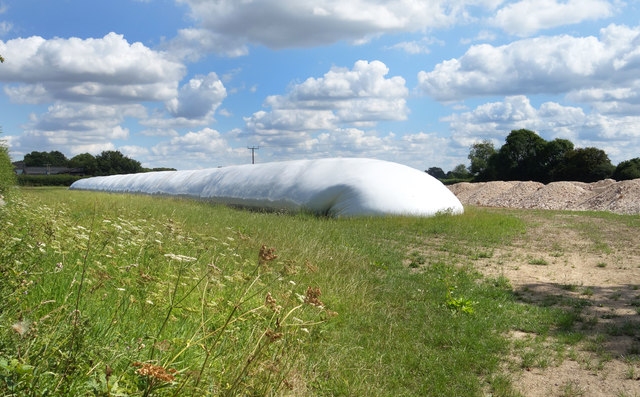
Giant Slug in a Field A great pile of something or other wrapped up in several acres of plastic sheeting.
Meanwhile, the rest of us are supposed to be avoiding carrier bags........
Giant Slug in a Field
A great pile of something or other wrapped up in several acres of plastic sheeting. Meanwhile, the rest of us are supposed to be avoiding carrier bags........
Gate into Withy Copse A small patch of private woodland near Bramley.
Gate into Withy Copse
A small patch of private woodland near Bramley.
Brenda Parker Way near Silchester Not looking very well trodden on this section, the Brenda Parker Way is a 125 km trail between Andover and Aldershot. <span class="nowrap"><a title="https://www.ldwa.org.uk/ldp/members/show_path.php?path_name=Brenda+Parker+Way" rel="nofollow ugc noopener" href="https://www.ldwa.org.uk/ldp/members/show_path.php?path_name=Brenda+Parker+Way">Link</a><img style="margin-left:2px;" alt="External link" title="External link - shift click to open in new window" src="https://s1.geograph.org.uk/img/external.png" width="10" height="10"/></span>
Brenda Parker Way near Silchester
Not looking very well trodden on this section, the Brenda Parker Way is a 125 km trail between Andover and Aldershot. LinkExternal link
Flat countryside south-east of Silchester Taken from the Brenda Parker Way footpath. Several other Geographs have been taken of this part of the gridsquare with each showing a different aspect of land use. The field is bordered to the left by Davnage Copse and Bramley Frith Wood.
Flat countryside south-east of Silchester
Taken from the Brenda Parker Way footpath. Several other Geographs have been taken of this part of the gridsquare with each showing a different aspect of land use. The field is bordered to the left by Davnage Copse and Bramley Frith Wood.
Flat countryside south-east of Silchester Taken from the Brenda Parker Way footpath. Several other Geographs have been taken of this part of the gridsquare with each showing a different aspect of land use. The field is bordered to the right by Davnage Copse and Bramley Frith Wood.
Flat countryside south-east of Silchester
Taken from the Brenda Parker Way footpath. Several other Geographs have been taken of this part of the gridsquare with each showing a different aspect of land use. The field is bordered to the right by Davnage Copse and Bramley Frith Wood.
Confluence of watercourses south of Silchester In the north-western corner of Bramley Frith Wood.
Confluence of watercourses south of Silchester
In the north-western corner of Bramley Frith Wood.
A view Southwest Looking Southwest from the eastern edge of the grid square, showing the open farmland, which dominates this square (Oh, and the Electricity Power lines).
A view Southwest
Looking Southwest from the eastern edge of the grid square, showing the open farmland, which dominates this square (Oh, and the Electricity Power lines).
Looking West Looking West from the eastern edge of the square.
Looking West
Looking West from the eastern edge of the square.
The Road to Bramley Taken from the Road Bridge close to Hollycross Farm, the railway track is straight through this cutting, which takes the train into Bramley station, just round the bend to the left, in the far distance.
The Road to Bramley
Taken from the Road Bridge close to Hollycross Farm, the railway track is straight through this cutting, which takes the train into Bramley station, just round the bend to the left, in the far distance.
Bramley Cutting Taken from the road bridge over the cutting, looking North.
Bramley Cutting
Taken from the road bridge over the cutting, looking North.
The Road to Holly Cross The Road to Holly Cross.
The Road to Holly Cross
The Road to Holly Cross.
Rural Lane Heading towards Minchens Lane and the railway line from Holly Cross
Rural Lane
Heading towards Minchens Lane and the railway line from Holly Cross
Holly Cross Farmhouse
A Leafy Lane Heading towards Minchens Lane from Holly Cross.
A Leafy Lane
Heading towards Minchens Lane from Holly Cross.
Boundary Wall - Barefoot's House
A pair of pylons
A pair of pylons
Hedge and spring crop
Show me another place!

Bramley is located at Grid Ref: SU6558 (Lat: 51.325376, Lng: -1.062723)

Administrative County: Hampshire

District: Basingstoke and Deane

Police Authority: Hampshire

What 3 Words

///humans.bends.spray. Near Bramley, Hampshire

Related Wikis

Bramley Training Area

Bramley Training Area is a British Army training camp, located south of the village of Bramley, Hampshire. Opened during World War I as an ammunition depot...

Bramley, Hampshire

Bramley is a village and parish in Hampshire, England. In the 2001 census it had a population of 3,348. It has a village shop, bakery, estate agency, pub...

Bramley railway station (Hampshire)

Bramley railway station is on the Reading to Basingstoke Line in Bramley, Hampshire, England. It is 46 miles 41 chains (74.9 km) from London Paddington...

St James' Church, Bramley

The Church of St James in Bramley, Hampshire, England was built in the Norman period and has been added to since. It is a Grade I listed building. ��2...

Bramley Green

Bramley Green is a small village in the civil parish of Bramley in the Basingstoke and Deane district of Hampshire, England. It lies approximately 4 miles...

Bullsdown Camp

Bullsdown Camp is the site of a former Iron Age plateau fort in the County of Hampshire. The site is heavily wooded, and close inspection is required to...

Bramley Corner

Bramley Corner is a village in Hampshire, England. == Governance == The village of Bramley Corner is part of the civil parish of Bramley. The village is...

Beaurepaire, Hampshire

Beaurepaire is a country estate at Sherborne St John in the English county of Hampshire. == History == Beaurepaire was owned by the Brocas family from...

Nearby Amenities

Located within 500m of 51.325376,-1.062723
Turning Circle
Lat/Long: 51.3246665/-1.0556182
Recycling
Location: overground
Recycling Type: container
Lat/Long: 51.3284505/-1.0667078
Coopers Court Play Area
Leisure: playground
Wheelchair: yes
Lat/Long: 51.3285649/-1.0612585
Rest Home
Applewood
Lat/Long: 51.3252753/-1.0585022
Barrier: bollard
Bollard: removable
Lat/Long: 51.3267222/-1.0561683
Barrier: bollard
Bollard: removable
Lat/Long: 51.3265849/-1.0558503
Noexit: yes
Lat/Long: 51.3257113/-1.0570313
Addr Housenumber: 20
Addr Street: Beckett Gardens
Lat/Long: 51.3240708/-1.0565326
Addr Housenumber: 6
Addr Street: Beckett Gardens
Lat/Long: 51.3241858/-1.055891
The data included in this document is from www.openstreetmap.org. The data is made available under ODbL.

Have you been to Bramley?

Leave your review of Bramley below (or comments, questions and feedback).