Bisbrooke

Civil Parish in Rutland

England

Bisbrooke

The Uppingham branch Framed in a dismantled bridge on the long closed Uppingham railway branch line, the tiny winding country road climbs up the wolds to the sky ...
The Uppingham branch Credit: Nick Leverton

Bisbrooke is a civil parish located in the county of Rutland, England. It is situated around 5 miles north of the town of Uppingham. The parish covers an area of approximately 2 square miles and is home to a small population of around 100 residents.

The village of Bisbrooke is primarily agricultural, with a number of farms and rural landscapes surrounding it. It is known for its picturesque countryside, offering scenic views and a tranquil atmosphere. The village itself is made up of a cluster of houses, with a small church, St. John the Baptist, serving as a focal point.

Bisbrooke is well-connected to neighboring areas, with good road links to Uppingham and Oakham, the county town of Rutland. The A47 road runs nearby, providing easy access to larger towns and cities such as Leicester and Peterborough. The village also benefits from a local bus service, connecting it to other rural communities in Rutland.

While Bisbrooke is a quiet and rural village, it offers a range of amenities and services for its residents. These include a village hall, which hosts various community events and activities, as well as a local pub, The Lake Isle, known for its traditional atmosphere and hospitality.

Overall, Bisbrooke is a charming and close-knit community that offers a peaceful countryside setting, while still being within reach of larger towns and cities. It is a place where residents can enjoy the beauty of nature, while also benefiting from the convenience of nearby amenities.

If you have any feedback on the listing, please let us know in the comments section below.

Bisbrooke Images

Images are sourced within 2km of 52.588604/-0.691513 or Grid Reference SP8899. Thanks to Geograph Open Source API. All images are credited.

The Uppingham branch Framed in a dismantled bridge on the long closed Uppingham railway branch line, the tiny winding country road climbs up the wolds to the sky ...
The Uppingham branch
Framed in a dismantled bridge on the long closed Uppingham railway branch line, the tiny winding country road climbs up the wolds to the sky ...
Disused Bridge There was probably a ford adjacent to this small bridge in days gone by.
Disused Bridge
There was probably a ford adjacent to this small bridge in days gone by.
Trackbed of the former railway to Uppingham
Dismantled bridge on the former Uppingham branch line Rutland has a mass of old railway tracks as well as several which still operate. The Seaton area is particularly rich in old trackbeds. The Uppingham branch from Seaton Junction to Uppingham was the last to open (in 1894) and the first to close (in 1960). This is where it crossed Seaton Road, just to the north of Seaton.
Dismantled bridge on the former Uppingham branch line
Rutland has a mass of old railway tracks as well as several which still operate. The Seaton area is particularly rich in old trackbeds. The Uppingham branch from Seaton Junction to Uppingham was the last to open (in 1894) and the first to close (in 1960). This is where it crossed Seaton Road, just to the north of Seaton.
Dismantled bridge on the Uppingham branch line Rutland has a mass of old railway tracks as well as several which still operate. The Seaton area is particularly rich in old trackbeds. The Uppingham branch from Seaton Junction to Uppingham was the last to open (in 1894) and the first to close (in 1960). This is where it crossed Seaton Road, just to the north of Seaton
Dismantled bridge on the Uppingham branch line
Rutland has a mass of old railway tracks as well as several which still operate. The Seaton area is particularly rich in old trackbeds. The Uppingham branch from Seaton Junction to Uppingham was the last to open (in 1894) and the first to close (in 1960). This is where it crossed Seaton Road, just to the north of Seaton
Downhill on Seaton Road Heading north towards Glaston.
Downhill on Seaton Road
Heading north towards Glaston.
Fields near Glaston Trig Point
Window Tax maybe? This large house on Norton Street, Uppingham, has several blocked up windows. It looks old enough to have been subject to the tax which was first imposed in 1681 and abolished in 1825.
Window Tax maybe?
This large house on Norton Street, Uppingham, has several blocked up windows. It looks old enough to have been subject to the tax which was first imposed in 1681 and abolished in 1825.
Station Road Industrial Estate, Uppingham Built on the site of the old branch line into Uppingham this industrial estate juts into the countryside along a small valley.
Station Road Industrial Estate, Uppingham
Built on the site of the old branch line into Uppingham this industrial estate juts into the countryside along a small valley.
Road Junction, Uppingham Taken from SP 870 997, this imaginatively planted roundabout is right on the edge of the square. The chevron pattern is typical of Rutland and Lincolnshire. The brick cottages and painted houses are in SP8699.
Road Junction, Uppingham
Taken from SP 870 997, this imaginatively planted roundabout is right on the edge of the square. The chevron pattern is typical of Rutland and Lincolnshire. The brick cottages and painted houses are in SP8699.
Glasshouses on Glaston Road, Uppingham Welland Vale Nurseries, a commercial plant company.
Glasshouses on Glaston Road, Uppingham
Welland Vale Nurseries, a commercial plant company.
A47 near Uppingham The Leicester to Peterborough road is a major feature in this square. Taken from SK 878 003 looking west towards Leicester.
A47 near Uppingham
The Leicester to Peterborough road is a major feature in this square. Taken from SK 878 003 looking west towards Leicester.
Fields near Uppingham Farmland to the south east of Glaston Road
Fields near Uppingham
Farmland to the south east of Glaston Road
Track to Ayston
Track to Ayston
Steep Hill
Steep Hill
Gate, Stile, Track, Footpath This gate is in the corner of the square
Gate, Stile, Track, Footpath
This gate is in the corner of the square
Field of Sheep
Field of Sheep
Crossroads The OS map shows the name Wing Burrows adjacent to this junction
Crossroads
The OS map shows the name Wing Burrows adjacent to this junction
Show me another place!

Bisbrooke is located at Grid Ref: SP8899 (Lat: 52.588604, Lng: -0.691513)

Unitary Authority: Rutland

Police Authority: Leicestershire

What 3 Words

///deduced.radar.newer. Near Uppingham, Rutland

Nearby Locations

Bisbrooke Bisbrooke

Related Wikis

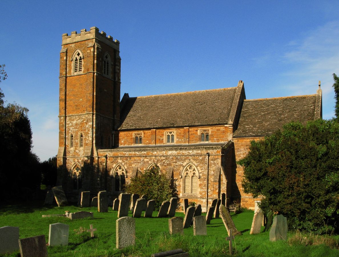
Church of St John the Baptist, Bisbrooke

The Church of St John the Baptist is a Church of England parish church in Bisbrooke, Rutland. A Victorian building, it is Grade II listed. == History... ==

Bisbrooke

Bisbrooke is a village and civil parish in the county of Rutland in the East Midlands of England. The village is situated about 2 miles (3.2 km) east of...

Glaston

Glaston is a village in the county of Rutland in the East Midlands of England. The population of the civil parish remained unchanged between the 2001 and...

St Andrew's Church, Glaston

St Andrew's Church is the Church of England parish church in Glaston, Rutland. It is a Grade II* listed building. == History == The earliest parts of the...

Nearby Amenities

Located within 500m of 52.588604,-0.691513
Bisbrooke
Place: village
Source Name: photograph
Lat/Long: 52.5876117/-0.6942256
Post Box
Post Box Type: wall
Lat/Long: 52.5874712/-0.694464
Defibrillator
Booth: K6
Covered: booth
Defibrillator Location: inside old red phone box, Bisbrooke - at crossroads
Disused Amenity: telephone
Emergency: defibrillator
Man Made: telephone_box
Lat/Long: 52.5875255/-0.6940898
Manor Farm
Place: farm
Source: Bing
Lat/Long: 52.5872413/-0.6912165
Village Farm
Place: farm
Source: Bing
Lat/Long: 52.5868497/-0.6934284
Information: guidepost
Tourism: information
Lat/Long: 52.5875245/-0.694153
The data included in this document is from www.openstreetmap.org. The data is made available under ODbL.

Have you been to Bisbrooke?

Leave your review of Bisbrooke below (or comments, questions and feedback).